
Order Total (1 Item Items):
Shipping Destination:

Britton & Rey (12 results)
Skip to main search results
Product Type
- All Product Types
- Books (6)
- Magazines & Periodicals
- Comics
- Sheet Music
- Art, Prints & Posters (1)
- Photographs
- Maps (2)
-
Manuscripts &
Paper Collectibles (3)
Condition
- All Conditions
- New
- Used
Binding
Collectible Attributes
- First Edition (1)
- Signed (1)
- Dust Jacket
- Seller-Supplied Images (6)
- Not Printed On Demand
Free Shipping
Seller Location
Seller Rating
-
Peque~nas Resistencias
Published by Paginas de Espuma
ISBN 10: 8495642352ISBN 13: 9788495642356
Book
Hardcover. Condition: Good. No Jacket. Former library book; Pages can have notes/highlighting. Spine may show signs of wear. ~ ThriftBooks: Read More, Spend Less 1.01.
-
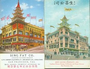
Two Vintage SF Chinatown Post Cards. Sing Fat Co. Leading Chinese Bazaar. Sing Chong Company. Both at the corner of Grant & California in San Francisco's China Town.
Published by San Francisco & Los Angeles, CA: Pacific Novelty Co., Britton & Rey - 1930., 1910
Manuscript / Paper Collectible Signed
Condition: Good. Two 3.5" x 5.5" Post Cards, Very Good with Color Illustration. One mailed, postmarked with MSS signed by Doris (Miller?).Text in English & Chinese.
-

Decorative Invoice for Woodin and Little, San Francisco.
Published by San Francisco, Calif.: Woodin and Little., 1895
Manuscript / Paper Collectible
Condition: Good. Lithograph by Britton and Rey, San Francisco. Windmills, pumps and wine makers.
-
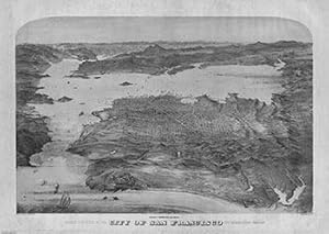
Bird's-eye view of the City of San Francisco and surrounding country
Published by San Francisco, S.A. Waterson for Burger & Evans., 1972
Art / Print / Poster
Condition: Good. Uncolored reproduction of the 1868 original. 58.5 x 89 cm. Colors more muted than in the reproduction.Col. lithographic view looking east over ocean beach to the city, with the East Bay and Sierra; Golden Gate at the lower left. Unnumbered key in lower margin. A separate numbered key was published as "Key to Snow & Roos view ." "This is the first of the 'run' of large bird's-eyes looking to the east".
-
RARE, UNRECORDED SERIES OF SIX COLOR LITHOGRAPHIC PRINTS FROM PHOTOGRAPHS OF NOTABLE LOCALS IN THE SAN FRANCISCO AREA
Published by Britton & Rey, San Francisco, 1900
Book
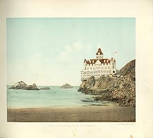
Soft cover. Condition: Very Good. Britton & Rey (illustrator). (Photographs) RARE, UNRECORDED SERIES OF SIX COLOR LITHOGRAPHIC PRINTS FROM PHOTOGRAPHS OF NOTABLE LOCALS IN THE SAN FRANCISCO AREA. San Francisco: Britton & Rey, circa 1900. Oblong 4to - 10" x 11-1/4". String bound, yapp edged, textured tan paper wrappers with spotting and staining to both front and back wrappers. [6] thick card leaves of plates, each leaf measuring 9" x 10-1/2" with a printed image measuring 6-3/4" x 8-1/2". Britton and Rey was the only West Coast printer that engaged in extensive photomechanical work. They called the color lithographs that they produced from photographs, "Photo-Chromes." WorldCat lists only one title containing Britton & Rey Photo-Chromes, i.e., "Welcome, La Fiesta de las Flores, Los Angeles, May 1st, 2nd and 3rd, 1902;" this title is held by only two libraries. The Photo-Chromes in the offered collection are: Cliff House and Seal Rocks San Francisco; light spotting, a short tear to right edge and to lower edge, both of which are confined to the margins. University of California, Berkeley; light spotting to lower margin and a short tear to right edge confined to the margin. Ocean Bluff, Santa Cruz; short tear to right edge confined to the margin. Devils Gulch Falls, Marin Co.; no condition issues. Glimpse of Grounds, Hotel del Monte; no condition issues. San Francisco Bay from Russian Hill; minor spotting, and creasing along left edge. The condition of this bound set of prints is VERY GOOD. No copies located on WorldCat, nor any other reference found to any of these images. RARE.
-
![Seller image for A Prospecting Party [Gold Rush Letter Sheet] for sale by Auger Down Books, ABAA/ILAB](https://pictures.abebooks.com/inventory/md/md31114698261.jpg)
A Prospecting Party [Gold Rush Letter Sheet]
Published by Britton and Rey, 1850
Seller: Auger Down Books, ABAA/ILAB, Marlboro, VT, U.S.A.
Association Member: ABAA ESA ILAB
Seller Rating:

Manuscript / Paper Collectible First Edition
Condition: Very Good. A series of four illustrations telling the story of a mining party that heads out with a pack mule, only to fail to find gold and lose their mule before returning to a new prospect with their clothes in shambles. This is entry 209 in Baird's California's Pictorial Letter Sheets, in which he sets the publication date as being prior to 1855. The series possibly illustrates scenes from a song. A particularly fine example on the classic blue wove paper of the period. Single sheet measuring 8 Ľ x 10 ľ inches on blue wove paper. Small chip to corner not affecting image, some older tape repairs verso at margins, else fine, very good plus overall and quite attractive.
-
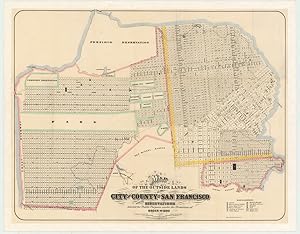
Map of the Outside Lands of the City and County of San Francisco Showing Reservations Selected for Public Purposes, under the Provisions of Order No. 800
Published by San Francisco, 1868
Seller: Neatline Antique Maps, Tiburon, CA, U.S.A.
Seller Rating:

Map
No Binding. Condition: Very Good. Mapping the Outside Lands a foundational map for the history of San Francisco.// This map is a critical document for San Francisco s history and urban development. It was created just after the lands outside the 1851 Charter line were turned over to the city of San Francisco following years of legal disputes. Today we think of the Outside Lands as the part of the city west of the dividing line at Divisadero St. (hence the name); namely, what is now the Richmond and Sunset, Golden Gate Park, and smaller adjacent neighborhoods. But it is interesting to note an area on the southeast of the map comprising part of Potrero Hill that is also designated as outside. From 1852 to 1866, the west side was the focus of two intense legal battles fought in parallel: a fight over whether the land belonged to the U.S. government or the City of San Francisco and a struggle over individual ownership of land plots at the private level. The critical point of these battles was that this land was ceded as part of the conclusion of the Mexican-American War by Mexico, not to California (which wasn t yet a state), but to the U.S. federal government. The Outside Lands Act of 1866 ruled in favor of the city, confirming that this land was part of San Francisco. This ruling set the stage for Order no. 800, mentioned in the title of our map, in which the board of supervisors decided the legal implications of the Outside Lands Act. The map identifies the following members of the Committee each with a street named after them: Chas. H. Stanyan, A.J. Shrader, Beverly Cole, Chas. Clayton, and Monroe Ashbury. The mapmakers located Golden Gate Park and Buena Vista Park but labeled them only Park. Two unlabeled lines, one dotted and one solid, run irregularly through the Sunset District; the former represents a line of sand drift, and the latter traces the Spring Valley Flume from San Mateo County.
-
5-sheet set showing San Francisco s post-1906 earthquake water supply [SF s first fireboat!]
Published by Britton & Rey, San Francisco, 1908
Seller: Neatline Antique Maps, Tiburon, CA, U.S.A.
Seller Rating:
Map
No Binding. Condition: Very Good. Four technical maps focussing on urban infrastructure and water supply and one engineering blueprint for a new fireboat, together reflecting San Francisco s coordinated response to the devastation of the 1906 earthquake. With an interesting provenance. Details This gorgeous set of five technical sheets was issued as supporting material for a detailed engineering report that proposed a comprehensive fire combatting infrastructure for the city of San Francisco. The report and associated maps, titled Reports on an Auxiliary Water Supply System for Fire Protection for San Francisco, California, were compiled by city engineer Marsden Manson following the catastrophic devastation of the 1906 earthquake. While the 173-page technical report has not survived in this case, the five pristinely preserved sheets embody its drive and spirit and represent some of the grand ideas being entertained in the rebuilding of San Francisco. The report provided the city council with a complete technical analysis of San Francisco s standing capacity and a comprehensive proposal for elaborating and extending it considerably. This report was published in 1908, only two years after the catastrophe, demonstrating the resilience and drive of San Franciscans. The goal, of course, was to make San Francisco less susceptible to the type of extensive urban conflagration that followed in the wake of the earthquake. The five map sheets were lithographed by the Britton & Rey company and consist of four thematic maps and the engineering blueprints for a fireboat for the San Francisco Fire Brigade. In unison, the set not only speaks to the impressive organizational capacity of post-earthquake San Francisco and highlights the crucial role played by technology and engineering in the recovery. Thus, while these sheets were conceived within the strict framework of safeguarding the city against fires, they have since become emblematic of America s great engineering legacy. The four maps included in this set are essentially identical in scale, street template, dimensions, etc. What distinguishes them from one another is their thematic overlay, which illustrates specific points in the overall plan that the report constitutes. Neatline is famous for its detailed and in-depth descriptions. To receive the full description for this listing free of charge, please contact us using the 'ask the seller' function below.
-
Single sheet (13 2/8 x 18 6/8 inches). A FINE lithographed view of Shasta, with original hand-colour in full. This fine view of Shasta in California is from "Kuchel & Dresel's California Views" which included "all the important cities and mining towns, with a few of Oregon and Washington, issued during 1855, 1856, 1857, and 1858. They were sometimes published by a local merchant, often the bookseller [as here]. Many of them were framed by a border of views of important buildings, ranches, and mines in and about the town portrayed." (Peters page 142). Kuchel was born in Zweibrucken in 1820, and when he arrived in America work initially for P.S. Duval in Philadelphia. He began collaborating with Dresel in 1853. Kuchel and Dresel capture this bird's-eye view of Shasta, in Shasta County, California only a few years after it was created as one of the original counties of California in 1850. In 1852 parts of the county's territory were given to Siskiyou County, and later to Tehama County in 1856. Named after Mount Shasta which in turn is from the English equivalent for the name of an Indian tribe that once lived in the area. Peters, "California on Stone", pages 143 and 145; see Streeter 2787. Catalogued by Kate Hunter.
-
Yreka, Siskiyou County, California. 1857
Published by [San Francisco]: A. Roman & Brother. 1856., 1856
Single sheet (18 2/8 x 24 inches, full margins, showing the plate-mark). A FINE lithographed view of Yreka with original hand-colour in full and heightened with gum arabic. This iconic view of the gold-mining town of Yreka in California is from "Kuchel & Dresel's California Views" which included "all the important cities and mining towns, with a few of Oregon and Washington, issued during 1855, 1856, 1857, and 1858. They were sometimes published by a local merchant, often the bookseller [as here]. Many of them were framed by a border of views of important buildings, ranches, and mines in and about the town portrayed." (Peters page 142). Kuchel was born in Zweibrucken in 1820, and when he arrived in America work initially for P.S. Duval in Philadelphia. He began collaborating with Dresel in 1853. Kuchel and Dresel capture a birds-eye view of this bustling Gold Rush town just a few years after the first discovery of gold and its founding. As such it is a remarkable and important historical record of the times. Initially named "Thompson's Dry Diggings" "Gold was discovered here in March 1851 by Abraham Thompson, member of a party which was enroute from Oregon to Scott Bar. Following a heavy rainstorm, particles of gold in the roots of grass pulled up by pack animals caused Thompson to wash three pans of gravel. The results convinced the party that the area was rich enough to work. In the party were Dr. F. G. Hearn, Judge Silas J. Day and a Mr. Bell, Thompson's partner. All staked claims on these flats thirty feet square, and it was named "Thompson's Dry Diggings". Within six weeks 2,000 prospectors rushed here to mine, but the need of water caused the settlement to move to the creek. And it became known as Shasta Butte City. This name being confused with Shasta, in Shasta County. Was changed to "I-E-K-A," The Indian word for Mt. Shasta. "Now Yreka" in 1852" (Plaque at site of Thompson's discovery of gold). Peters, "California on Stone", pages 143 and 146; see Streeter 2787. Catalogued by Kate Hunter.
-
Weaverville, 1856. Trinity County, California
Published by [San Francisco: ?Fagg & Feast, 1856]., 1856
Single sheet (17 4/8 x 25 inches, full margins, showing the plate-mark). A FINE lithographed view of Weaverville (a bit browned). This fine view of Weaverville in California is from "Kuchel & Dresel's California Views" which included "all the important cities and mining towns, with a few of Oregon and Washington, issued during 1855, 1856, 1857, and 1858. They were sometimes published by a local merchant, often the bookseller [as here]. Many of them were framed by a border of views of important buildings, ranches, and mines in and about the town portrayed." (Peters page 142). Kuchel was born in Zweibrucken in 1820, and when he arrived in America work initially for P.S. Duval in Philadelphia. He began collaborating with Dresel in 1853. Kuchel and Dresel capture this early large-scale bird's-eye view of the Gold Rush town of Weaverville, and it is the earliest recorded in Reps, "Views and Viewmakers of Urban America" (443). Weaverville was only founded in 1850 during the Gold Rush, and attracted a large proportion of Chinese miners. "Weaverville owes its origin to the rush into northwestern California, which the discoveries of Pearson B. Reading started. By the summer of 1851 it was a thriving mining center, inhabited largely by Missourians, and had a reputation of being the roughest camp in California. And for years afterwards this reputation held. William H. Brewer was in Weaverville in September, 1862. He.comments on the high cost of freights, and says further: 'Sluices run through the town. There are multitudes of Chinese. There are twenty-eight saloons and liquor holes in the place and fighting and gambling are favorite pastimes.' Today Weaverville, Trinity's county seat since its organization, is a quiet and prosperous town with extensive interests in gold mining" Watson "California in the Fifties" (40). Peters, "California on Stone", pages 143 and 146; see Streeter 2787. Catalogued by Kate Hunter.
-
Yreka, Siskayou Cy. A view from the Humbug Trail with Shasta Bute in the Distance
Published by San Francisco: G. Barthrop, 1853., 1853
Single sheet (9 4/8 x 12 inches, full margins). Lithographed view of Yreka. Fine lithographed view of the of the gold-mining town of Yreka in California. "The firm of Britton & Rey was undoubtedly the largest producer of lithographs in California. The two men were the Currier & Ives of the West, resembling that famous combination not only in the volume of the production but in their personal relationship as well. Joseph Britton was a Yorkshire Englishman, born in 1825. At ten years of age he came to America and lived in New York until he was twenty-four. As a young man he apparently worked there as a lithographer. In 1849 the lure of the California Gold Rush struck him and he joined the George Gordon party, the first gold seekers to make the journey by way of Lake Nicaragua. He went directly to the gold fields and prospected until he became discouraged by his lack of success and returned to San Francisco. There, in 1852, he formed a partnership with . J.J. Rey. Jacques Joseph Rey was born in Bouxviller, Alsace, in 1820. As a young man he studied art and lithography. About 1850 he went by way of Panama to California, where, contrary to the custom of those days, he did not seek a fortune in the mines" (Peters page 62-63). Initially named "Thompson's Dry Diggings" "Gold was discovered here in March 1851 by Abraham Thompson, member of a party which was enroute from Oregon to Scott Bar. Following a heavy rainstorm, particles of gold in the roots of grass pulled up by pack animals caused Thompson to wash three pans of gravel. The results convinced the party that the area was rich enough to work. In the party were Dr. F. G. Hearn, Judge Silas J. Day and a Mr. Bell, Thompson's partner. All staked claims on these flats thirty feet square, and it was named "Thompson's Dry Diggings". Within six weeks 2,000 prospectors rushed here to mine, but the need of water caused the settlement to move to the creek. And it became known as Shasta Butte City. This name being confused with Shasta, in Shasta County. Was changed to "I-E-K-A," The Indian word for Mt. Shasta. "Now Yreka" in 1852" (Plaque at site of Thompson's discovery of gold). Peters "California on Stone" pages 62-63, 86. Catalogued by Kate Hunter.

![Seller image for 5-sheet set showing San Francisco s post-1906 earthquake water supply [SF s first fireboat!] for sale by Neatline Antique Maps](https://pictures.abebooks.com/inventory/md/md31297556734.jpg)