Order Total (1 Item Items):
Shipping Destination:

Ensign & Thayer (19 results)
Skip to main search results
Product Type
- All Product Types
- Books (19)
- Magazines & Periodicals
- Comics
- Sheet Music
- Art, Prints & Posters
- Photographs
- Maps
-
Manuscripts &
Paper Collectibles
Condition
- All Conditions
- New
- Used
Binding
- All Bindings
- Hardcover (6)
- Softcover
Collectible Attributes
- First Edition (1)
- Signed
- Dust Jacket (1)
- Seller-Supplied Images (14)
- Not Printed On Demand
Free Shipping
Seller Location
Seller Rating
-
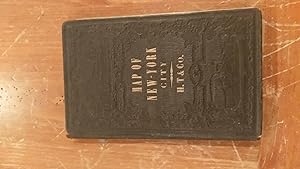
Ensign & Thayer Pocket Map, Nyc Environs: Map Of The City Of New York, With The Adjacent Cities Of Brooklyn & Jersey City,.
Published by Ensign & Thayer Publishers, New York, 1853
Hardcover. Condition: Very Good -. Bound In Brown Cloth With Gold Titles. Complete With The Hand Colored Map Tipped In At The Rear Of The Book. The Map Titled" Map Of The City Of New York, With The Adjacent Cities Of Brooklyn & Jersey City, 1853" Has A Few Splits At The Folds But Remains Bright. The Book Has A Loose Rear Hinge And Foxing. Book.
-
Map of the United States from the Latest Authorities
Published by New York, New York, 1848
Seller: High Ridge Books, Inc. - ABAA, South Deerfield, MA, U.S.A.
Association Member: ABAA ESA ILAB SNEAB
Seller Rating:

Generally fair condition, minor water stain at right. Needs restoration. Original top rod, lacks bottom stick, linen backed. Severe age toning. Colors oxidized. Shows only the eastern portion of the United States, with an inset of Oregon Territory at the top and a large map of Texas at the bottom right. There is also a small inset map of the southern half of Florida. Drawn & Engraved by William S. Barnard. A very attractive map, fully colored by county, with a decorative border showing the states and territories with their sizes and populations. In spite of its current unaestetic appearance, this is a quite rare map with its large inset map of Texas.
-

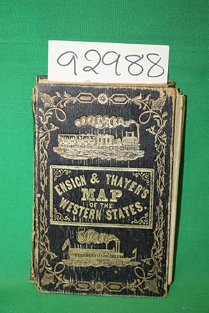
ENSIGN & THAYER'S TRAVELLER'S GUIDE THROUGH THE STATES OF OHIO, MICHIGAN, INDIANA, ILLINOIS, MISSOURI, IOWA, AND WISCONSIN; WITH RAILROAD, CANAL, STAGE, AND STEAMBOAT ROUTES; ACCOMPANIED WITH A NEW MAP OF THE ABOVE STATES.
Published by New York, 1850
Book First Edition
Hardcover. Condition: Very Good. No Jacket. 1st Edition. 16mo, heavily, pictorially stamped red roan, little edge rubbed, few small soil spots, containing text block (detached) of 32pp. + final publisher's ad leaf and the folding map, approx. 21.5" x 27.25," vignettes at each corner, within ornate typographical bordering - an odd floral conceit - the coloring in green, red & yellow, generally clean and bright, but with the usual tiny, occasional breaks at folds. HOWES/HARTLEY E-165. A Good+ to Very Good copy.
-
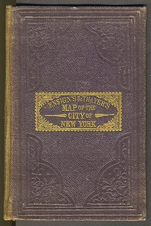
Map of the City of New York, with the Adjacent Cities of Brooklyn and Jersey City, and the Village of Williamsburg: With Street Directory of The City of New York
Published by Ensigns & Thayer, New York, 1849
Seller: Antipodean Books, Maps & Prints, ABAA, Garrison, NY, U.S.A.
Association Member: ABAA ANZAAB ESA ILAB
Seller Rating:

Boards over folding map. Condition: Very good condition. Map of New York City and surroundings. The main map includes most of Governor's Island and all of Lower Manhattan from the Battery to 32nd Street, as well as parts of the City of Brooklyn on the opposite shore of the East River from the Navy Yard to Sackett Street, and the shoreline of Williamsburg. There are small inset maps top left of Jersey City, New Jersey, as well as the "Northern Part of New York Island" (a simplified map of the part of Manhattan not included in the main map, then a largely rural and undeveloped area). 5 3/4 x 3 1/2", maroon embossed cloth covers, 28pp, map 20 1/4 x 16 3/4". Cover sunned at spine, rubbed at edges, internally clean and bright.
-
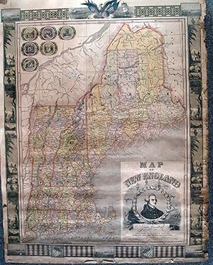
Map of New England
Published by New York, New York, 1847
Seller: High Ridge Books, Inc. - ABAA, South Deerfield, MA, U.S.A.
Association Member: ABAA ESA ILAB SNEAB
Seller Rating:
Colored map of New England states. With fine unusual vignette border.Shows old and new Railroads.
-

Presidents of the United States
Published by Buffalo, Buffalo, 1848
Seller: High Ridge Books, Inc. - ABAA, South Deerfield, MA, U.S.A.
Association Member: ABAA ESA ILAB SNEAB
Seller Rating:
Garish decorative broadside with portraits of the first twelve presidents, including the just-elected Taylor. At the center is a small copy of Trumbull's depiction of the signing of the Declaration. Other patriotic decorative elements added. Linen-backed, with original rods. Small tear with loss at top left margin. Generally very good condtion, moderately worn.
-
Map of Canada East and West.
Published by Ensign & Thayer, Buffalo, New York, 1850
Seller: Jeffrey H. Marks, Rare Books, ABAA, Rochester, NY, U.S.A.
Seller Rating:
Outline color; colored decorative boards. 21-1/2 x 26-1/2 inches, folded into gilt-decorated and gilt-lettered red leather portfolio as issued. A few tiny reinforcements at fold intersections; map otherwise fine. There a few small losses to the spine of the portfolio and light rubbing at edges.
-
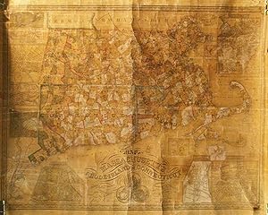
Map of Massachusetts, Rhode-Island & Connecticut Compiled from the Latest Authorities
Published by New York, New York, 1851
Seller: High Ridge Books, Inc. - ABAA, South Deerfield, MA, U.S.A.
Association Member: ABAA ESA ILAB SNEAB
Seller Rating:
Wall map of lower New England, apparently never affixed to rods. Full color by town, some of the colors have oxidized to a whitish shade. Age-toned, light creasing, otherwise very good condition. 14 inset maps, including Boston, New York, Norwich, Fall River, New Haven, Salem, Lowell, Providence, Hartford, Woonsocket and Pawtucket. Also has inset maps of the factories around Warwick & Coventry Rhode Island, North Adams, Mass., and Canton, Mass.
-
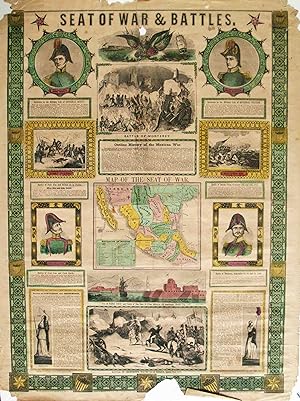
Seat of War & Battles
Published by New York, New York, 1847
Seller: High Ridge Books, Inc. - ABAA, South Deerfield, MA, U.S.A.
Association Member: ABAA ESA ILAB SNEAB
Seller Rating:
Patriotic broadside issued during the Mexican War, with a small map of the seat of war, portraits of Generals Scott and Taylor of the U.S., Santa Anna and General Ampudia of the Mexican Army. 4 battle views. Damaged at bottom border near center, with a small wedge out. The damage does not extend beyond the border. Mild damage at top corners, tear repaired near center with no loss.
-
Ensign & Thayer's Travellers' Guide Through the States of Ohio, Michigan, Indiana, Illinois, Missouri, Iowa, and Wisconsin; with Railroad, Canal, Stage, and Steamboat Routes; accompanied with a New Map of the Above States.
Published by Ensign, Thayer, & Co., New York, 1851
Seller: Jeffrey H. Marks, Rare Books, ABAA, Rochester, NY, U.S.A.
Seller Rating:
33 [2, ads] pp. The folding colored "Map of the Western States" by J. M. Atwood measures approx. 211/2 x 27-1/4 inches, with engraved vignettes at the corners and an elaborate floral border. 12mo, publisher's gilt leather. Very attractive. There are a few tiny losses to the spine of the folder and light rubbing to its edges.
-
Travellers' Guide Through the States of Ohio, Michigan,Indiana,Illinois,Missouri, Iowa,and Wisconsin WITH MAP
Published by ENSIGN AND THAYER, NEW YORK, 1851
HARD BACK BLACK. Condition: GOOD. Folded into 3 1/2 x 5 within a Gold gilt tooled leather hardback covers. Bright Gilt floral borders, steam engines w/ 2 open cars also St. Louis. Side paddle steamship with Billowing smoke stack and a flag on stern and bow. Spine is torn. Foxed pages. General wear. 21.5" X 26.5" Fold out map is torn. DATE PUBLISHED: 1851 EDITION: 32+.
-
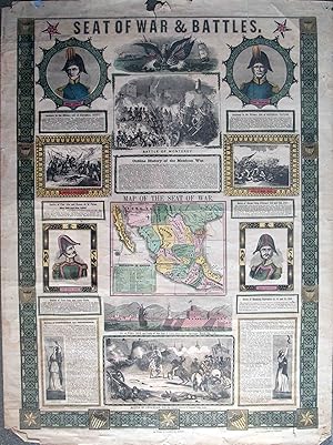
Seat of War & Battles
Published by New York, New York, 1847
Seller: High Ridge Books, Inc. - ABAA, South Deerfield, MA, U.S.A.
Association Member: ABAA ESA ILAB SNEAB
Seller Rating:
Patriotic broadside issued during the Mexican War, with a small map of the seat of war, portraits of Generals Scott and Taylor of the U.S., Santa Anna and General Ampudia of the Mexican Army. 4 battle views. Excellent condition, with one small tear in the top margin, not affecting the printed part of the broadside.
-
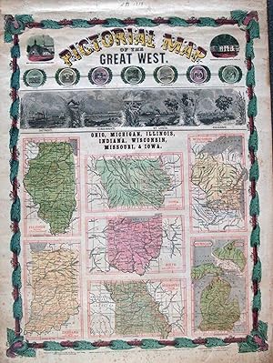
Pictorial Map of the Great West. Ohio, Michigan, Illinois, Indiana, Wisconsin, Missouri, Iowa
Published by New York, New York, 1848
Seller: High Ridge Books, Inc. - ABAA, South Deerfield, MA, U.S.A.
Association Member: ABAA ESA ILAB SNEAB
Seller Rating:
A spectacular broadside in the flamboyant style of many others published during and shortly after the Mexican War, such as the series of Ornamental Maps of the United States. Fine condition, one short tear at bottom left mended. This piece is interesting typographically as the names of the states on the individual maps as well as the borders of those maps have been printed in red. The remainder of the map has been printed in black and hand colored. This sheet has a decorative border, ornamental title, small individual maps of the seven states listed in the title, and uncolored views of Detroit, Cincinnati, St. Louis, and Chicago. There are also small views at the top of the Old Statehouse in Chilicothe, Ohio and William Henry Harrison's residence in North Bend, Ohio. This is the first time we have ever seen this most striking piece which is among the earliest to elevate Chicago to a prominent place among Midwestern cities.
-
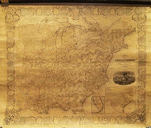
Map of the United States with its Territories [WALL MAP]
Published by Ensign and Thayer, New York, 1851
Seller: Yesterday's Gallery, ABAA, East Woodstock, CT, U.S.A.
Seller Rating:
Original wall map, 35 by 32 inches. Professionally restored, Very Good.
-
Map of the United States with its Territories [WALL MAP]
Published by Ensign and Thayer, New York, 1851
Original wall map, 35 by 32 inches. Professionally restored, Very Good.
-
Map of the United States from the Latest Authorities
Published by New York, New York, 1847
Seller: High Ridge Books, Inc. - ABAA, South Deerfield, MA, U.S.A.
Association Member: ABAA ESA ILAB SNEAB
Seller Rating:
Modern linen backing, varnish removed. Full color by county, some age toning. Decorative border with information on each state. Small inset map of Oregon, large inset at bottom right of Texas. Shows the United States to eastern Texas. A classic Manifest Destiny-era map, with a wonderful cartouche showing an eagle sitting on top of a globe with a properous country unfolding behind it. The map of Texas measures 20x23 cm.
-
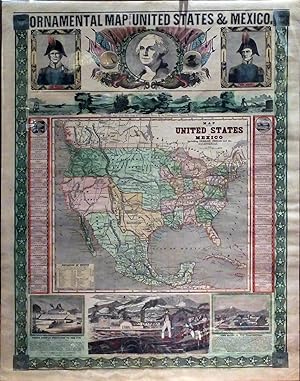
Ornamental Map of the United States & Mexico. Hand-colored lithographic Map.
Published by Ensigns [sic] and Thayer, New York, 1848
Seller: Jeffrey H. Marks, Rare Books, ABAA, Rochester, NY, U.S.A.
Seller Rating:
Printed ornamental borders; portraits of George Washington and Generals Taylor and Scott at top, with patriotic views at the lower edge; Table of Distances in Mexico at the lower left corner; and border panels listing statistics of the States and Territories. 29 x 21 inches A few small and unobtrusive losses in the area of the portraits with old reinforcements on verso; some shallow marginal chipping. Generally bright and very attractive. This map was issued several times from 1846-51 reflecting border changes resulting from the Mexican-American War.
-
ENSIGN & THAYER. Ornamental Map of the United States & Mexico. New York: Ensign & Thayer, 1848. Lithograph map, with full original hand color, sheet dimensions: 31 x 23 inches (excellent condition, edges reinforced, slight chipping on top right edge). Created at a time of incredible expansion for the nation, this map boldly proclaims in no uncertain terms that America is poised to emerge as a dominant global force. 1848 was a pivotal year that saw the U.S. on the cusp of victory in the Mexican American War, which ended with Mexico being forced to cede almost half of her territory at the Treaty of Guadalupe Hidalgo on the 4th of July of that year. Texas had become a state in 1845, and California, as well as the area to the north which would become Oregon and Washington State were being recognized as U.S. Territories. This sudden addition of land was the first major expansion of the country since the Louisiana Purchase and began the great migration to the west and southwest that continues to this day. Portraits of Generals Zachary Taylor and Winfield Scott-two heroes of the war with Mexico-flank a central image of a mythic-looking and approving George Washington framed in flags and sunbeams. At the base of the sheet, two scenes depict an ancient Mexican culture that has just be defeated by the upstart American conquerors. The "Panoramic View from New York to the Pacific Ocean by the Contemplated Oregon Railroad", located between the map and the top register, is a highly stylized cross-section of the newly transcontinental America. This pictorial expression of 'Manifest Destiny' anticipates the construction of a transnational railway more than twenty years before such an ambition was realized. In "An American Exhibiting to the Sovereigns of Europe the Progress of his country" a healthy Walt Whitman-looking figure in fashionable and casual dress stands on the battlement of a fort bristling with cannon, confidently gesturing to a vista depicting scenes that embody the virtues of America's natural resources and the ingenuity of her people. The European dignitaries are outfitted in stuffy formal garb and look sallow, old, paunched, and intimidated. The landscape features a crowded river filled with steam and sailing ships, rich farmlands dotting lush fields, and bold cloud-piercing mountains surmounted only by an ultra-modern balloon rising in the sky. This juxtaposition was meant to highlight the difference between the Old world and the New, with America as the leaders of the future-a message that the readers of that time must have heard loud and clear. This patriotic tableau, richly ornamented, was the ultimate statement that the popular notion of 'Manifest Destiny' was being fulfilled in the west. In the map of the United States and Mexico, which makes up the centerpiece of the tableau, the United States is shown to extend from sea to sea. Her new possessions include the vast new territory of 'New California', occupying all of the modern states of California, Nevada, Utah, and most of Arizona. New Mexico runs down the length of the upper Rio Grande, while an enlarged Texas (which became a U.S. state in 1845), prominently occupies the center of the map. Also featured is the Oregon Territory, in the Pacific Northwest, which officially became part of the U.S. in 1846, while the vast 'Missouri Territory' and the 'Indian Territory' (the latter still reserved for Native Americans) occupy most the Great Plains. References: Wheat, 'California Gold Fields', no.38; Wheat 'Mapping the Transmississippi West', no. 557. Location note: Texas drawer.
-
Pictorial Map of the Great West (Illinois/Indiana/Iowa/Ohio/Missouri/Wisconsin/Michigan)
Published by Ensign & Thayer, New York/Buffalo, 1818
Seller: Arader Galleries of Philadelphia, PA, Philadelphia, PA, U.S.A.
Seller Rating:
Book
N/A. Condition: Very Good. Dust Jacket Condition: N/A. Engraving with original hand-color. Sheet size: 31 x 23". Frame size: 40 1/4 x 32 1/4". Inventory#: p2012pfat.

![Seller image for Map of the United States with its Territories [WALL MAP] for sale by Yesterday's Gallery, ABAA](https://pictures.abebooks.com/inventory/md/md30242993922.jpg)
![Seller image for Map of the United States with its Territories [WALL MAP] for sale by Babylon Revisited Rare Books](https://pictures.abebooks.com/inventory/md/md31810082693.jpg)