Order Total (1 Item Items):
Shipping Destination:

Johann Baptiste Homann (44 results)
Skip to main search results
Product Type
- All Product Types
- Books (31)
- Magazines & Periodicals
- Comics
- Sheet Music
- Art, Prints & Posters (5)
- Photographs
- Maps (8)
-
Manuscripts &
Paper Collectibles
Condition
- All Conditions
- New
- Used
Binding
Collectible Attributes
- First Edition (2)
- Signed
- Dust Jacket (1)
- Seller-Supplied Images (29)
- Not Printed On Demand
Free Shipping
Seller Location
Seller Rating
-

General Map of Great Britain & Ireland with part of Holland, Flanders & France agreeable to History. Reproduction
Published by Heirs of Mr Homann this Sackville Press, London, 1111
Paperback. Condition: Very Good. this a reproduction circa 1980. Book.
-
General Map of Great Britain & Ireland with part of Holland, Flanders & France agreeable to History. Reproduction
Published by Heirs of Mr Homann this Sackville Press, London, 1111
Paperback. Condition: Very Good. this a reproduction circa 1980. Book.
-
General Map of Great Britain & Ireland with part of Holland, Flanders & France agreeable to History. Reproduction
Published by Heirs of Mr Homann this Sackville Press, London, 1111
Paperback. Condition: Very Good. this a reproduction circa 1980. Book.
-
General Map of Great Britain & Ireland with part of Holland, Flanders & France agreeable to History. Reproduction
Published by Heirs of Mr Homann this Sackville Press, London, 1111
Paperback. Condition: Very Good. this a reproduction circa 1980. Book.
-
General Map of Great Britain & Ireland with part of Holland, Flanders & France agreeable to History. Reproduction
Published by Heirs of Mr Homann this Sackville Press, London, 1111
Paperback. Condition: Very Good. this a reproduction circa 1980. Book.
-
General Map of Great Britain & Ireland with part of Holland, Flanders & France agreeable to History. Reproduction
Published by Heirs of Mr Homann this Sackville Press, London, 1111
Paperback. Condition: Very Good. this a reproduction circa 1980. Book.
-
General Map of Great Britain & Ireland with part of Holland, Flanders & France agreeable to History. Reproduction
Published by Heirs of Mr Homann this Sackville Press, London, 1111
Paperback. Condition: Very Good. this a reproduction circa 1980. Book.
-
General Map of Great Britain & Ireland with part of Holland, Flanders & France agreeable to History. Reproduction
Published by Heirs of Mr Homann this Sackville Press, London, 1111
Paperback. Condition: Very Good. this a reproduction circa 1980. Book.
-
![Seller image for [Portfolio]: Antique Maps of the World in Color for sale by Between the Covers-Rare Books, Inc. ABAA](https://pictures.abebooks.com/inventory/md/md31614799540.jpg)
[Portfolio]: Antique Maps of the World in Color
Published by Sterling Publishing House, Co., Inc, New York, 1960
Seller: Between the Covers-Rare Books, Inc. ABAA, Gloucester City, NJ, U.S.A.
Association Member: ABAA ESA ILAB IOBA
Seller Rating:

First Edition
Unbound. Condition: Very Good. Portfolio. Color facsimiles of 36 historical maps. Each map measures approximately 12" x 9", printed on 17" x 11�" paper with descriptive text in the left margin. Housed with a title page sheet and unprinted top sheet in a four-fold chemise. Unprinted topsheet sunned at the edges, first two leaves with some very light toning and a couple of tiny corner creases; the maps are otherwise bright and fine. The chemise is good only with toning, wear, and soil, and a 1" creased tear on the cover panel. A nice production, and the chemise has done its job, keeping the maps bright and fresh.
-
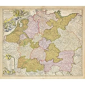
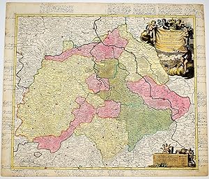
Imperium Romano Germanicum in suos Circulos Eleotratus et Status
Published by Nuremberg, 1720
Seller: Bruce Marshall Rare Books, Cheltenham, United Kingdom
Seller Rating:
Map
No Binding. Condition: Very Good. Copper engraved map, hand colourd, large decorative cartouches including portrait, coats of arms, central vertical fold repaired without loss, overall slight toning, Nuremberg, c.1720. A decorative map of Germany during the Roman Empire. Extends from Paris to Warsaw and Denmark to Italy, showing the many cities established by the Romans. Johann Baptiste Homann (1664-1724) was the most prominent and prolific map publisher of the 18th century. After studying in a Jesuit school with the intent of becoming a Dominican Priest, before converting to Protestantism in 1687. Following his conversion he moved to Nuremberg and worked as a notary until 1702 where he founded the famous Homann Heirs publishing company. In the next 5 years he would publish hundreds of maps and develop a distinctive style recognised by heavy engraving, elaborate allegorical cartouche work and vibrant hand colouring. Due to the lower cost of printing in Germany, Homann was able to undercut the French and Dutch publishers, establishing himself as an important entity in the European map market. In 1715, Johann was named Imperial Geographer to the Holy Roman Empire by Charles VI and made a member of the Prussian Academy of Sciences. This appointment gave him access to the most up to date cartographic information, and most importantly his reputation and contacts gained him imperial printing privileges which protected his publications. Johann is best known for this Grosser Atlas ueber die ganze Welt, or the Grand Atlas of the World, published in 1716. Provenance: H.A.J. Staples of Her Majesty s Service.
-
Condition: -. Altkolorierter Kupferstich. 54 x 61 cm. R�nder leicht gebr�unt. Guter Zustand.
-
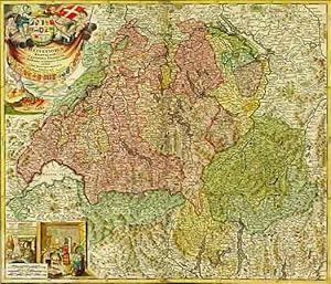
Potentissimae Helvetiorum Reipublicae cantones tredecim cum Foederatis et Subjectis Provinciis exhibiti (ca. 1:580'000).
Published by Nurnberg, Bapt. Homann, (a Ioh. Baptista Homanno Noribergae), 1732,, 1732
Seller: Harteveld Rare Books Ltd., Fribourg, Switzerland
Association Member: ILAB VEBUKU
Seller Rating:

47x56 cm, Carte grav�e colori�e / Kupferstich-Karte, Koloriert, kleinere fehlstelle Ecken oben links und rechts in der Mitte und rechts am Rand, 1 Blatt 48 x 57 cm, Karte auf Lwd aufgezogen, leicht fleckig. Please notify before visiting to see a book. Prices are excl. VAT/TVA (only Switzerland) & postage. Ryhiner 6086; Graf BSL IIa/36; Sandler 134; Blumer S. 85, Nr. 196. Ursprungswerk Atlas novus. v. Gabriel Walser (1769).
-
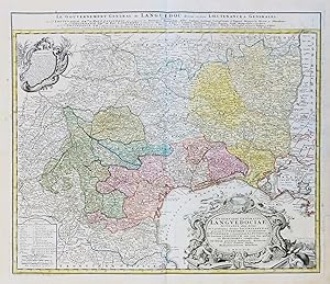
Gubernatio Generalis Languedociae Occitania olim dictae. / Le Gouvernement General de Languedoc" - Languedoc-Roussillon Toulouse Montpellier Narbonne Perpignan carte Homann
Published by N�rnberg, Homann Erben, 1742
Seller: Antiquariat Steffen V�lkel GmbH, Seubersdorf, Germany
Seller Rating:
Map
pr�chtige altkolorierte Original Kupferstich-Karte vonHomann von ca. 1740 Blattmasse ca.55 x63 cm gut erhalten Original! - Kein Nachdruck! - Keine Kopie! Sprache: Franz�sisch.
-
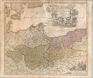
Tabula Marchionatus Brandeburgici et Ducatus Pomeraniae The vital core of the Kingdom of Prussia in the mid-18th century.
Published by c. 1750, 1750
Condition: Very Good. The Margraviate of Brandenburg and adjacent Duchy of Pomerania were rival territories since the 12th century. The conflict often escalated to open war between the two, either as independent fiefs or as vassals subject to a king or emperor. At the time this map was published, both regions were part of the Kingdom of Prussia. Much of the territory of Pomerania (red) was acquired from Sweden during a series of successful wars earlier in the century. The image shows a detailed overview of the complex political situation. Original color highlights the extent of each territory, with neighboring duchies and kingdoms also outlined and named. Geographic features like mountain ranges and forests are depicted pictorially. A fascinating variety of place names are labeled, including fortified cities, ecclesiastical towns, monasteries, hunting lodges, and more. Two decorative cartouches are also present. One, lower right, shows a putti with measuring devices over two distance scales. The second, more elaborate, cartouche can be seen in the upper right. It's framed by several puttis holding aloft a banner containing the title, as well as the Royal Coat of Arms of the Holy Roman Empire and Prussia. Sheet Width (in) 23.6 Sheet Height (in) 19.7 Condition Description "The sheet shows moderate to heavy discoloration throughout the image and around the outer margins. Several stains and spots visible in the upper half of the sheet and 2 tears, about 3" each, have been repaired on the verso with archival tape. Original hand color. Not in good condition, but better than fair.".
-
REGNI BOHEMIAE DUCATUS SILESIAE, Marchionatus Moraviae et Lusatiae Tabula Generalis?
Published by Nuremberg, 1710, 1710
Seller: Libreria Anticuaria Farr�, Barcelona, BARCE, Spain
Seller Rating:
. 47 x 56,5 cm. Mapa calcogr�fico coloreado a mano. Alemania.
-
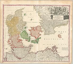
Regni Daniae The kingdom of Denmark after the Great Northern War.
Published by c. 1730, 1730
Condition: Very Good. This beautiful copperplate engraved map was published in Nuremberg by Johann Baptiste Homann around 1730. It shows the Kingdom of Denmark situated between the North and Baltic Seas. About a decade earlier, the end of the Great Northern War saw Denmark relinquish territorial claims on the European continent and Swedish coast, reducing the nation to its depicted size. Original color, applied by hand, distinguishes the various duchies and islands that comprise the kingdom. Pictorial elements identify geographic features like mountains and forests and a variety of toponyms label an interesting mix of places throughout the image. It was a largely agricultural community, as reflected by the decorative title cartouche in the upper right. A variety of draft animals and livestock are overseen by two crudely dressed men wielding clubs. These are the woodwose, or wild men, that play a prominent role in Scandinavian mythology and can still be found on the Royal Danish Coat of Arms today. Sheet Width (in) 23.75 Sheet Height (in) 21 Condition Description Moderate toning and spotting visible in the margins, along with some wear to the outer edges of the sheet. The image is clean and shows a nice impression with original hand color.
-
Ducatus Meklenburgici Tabula Generalis continens Duc. Vandaliae et Meklenburg Comitatum et Episcopatum Swerinensem Rostochiense et Stargardiense Dominium. -
Published by N�rnberg: Joh. Bap. Homann [um ]., 1720
Art / Print / Poster
Kupferstich 49 x 57 cm, Blattgr��e 54,5 x 62,5 cm. Der altkolorierte Kupferstich von Johann Baptist Homann ohne Privileg zeigt das Herzogtum Mecklenburg mit den angrenzenden Gebieten. Am oberen Bildrand die Titelkartusche mit dem Wappen und sechs Putten in kraftvollem Altkolorit. - Johann Baptist Homann, 1663-1724, Kupferstecher und Verleger in N�rnberg. - Das Papier leicht gebr�unt, mittig gefaltet, daneben zwei Quetschfalten.
-
Circulus Saxoniae Superioris in quo Ducatus & Electoratus Saxoniae. Iohanne Baptista Homanno.
Published by Norimbergae : Iohann Baptist Homann, (hacia 1695)
Seller: BALAGU� LLIBRER�A ANTIQU�RIA, Santa Coloma de Farners, GIRON, Spain
Seller Rating:
Map
Sin Encuadernar. Condition: Bueno. Primera edici�n. Iluminado a mano de �poca. Size: 63 x 54 Cm.
-
Ducatus Brunsuicensis in Ejusdem Tres Principatus Calenbergicu Scilicet & Grubenhagense et in Guelpherbitanum. Episcopatus Hildesiensis, Principatus Halberstadiensis.
Published by Nuremberg, 1724
Seller: BALAGU� LLIBRER�A ANTIQU�RIA, Santa Coloma de Farners, GIRON, Spain
Seller Rating:
Map
Sin Encuadernar. Condition: Bueno. Con anotaciones manuscritas de �poca en los m�rgenes. Coloreado a mano de �poca. Size: 62,5 x 54 Cm.
-
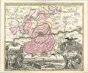
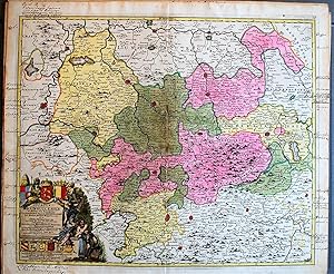
Abbildung der Keys Freyen-Reichs-Wahl-und-Handelstatt Frankfurt Am Mayn Mit Ihrem Gebiet Beautiful Homann map of the imperial free city of Frankfurt.
Published by c. 1717, 1717
Condition: Very Good. The city of Frankfurt (formerly known as Frankfurt am Main to distinguish it from other cities of the same name) was one of the most important urban centers in the entire Holy Roman Empire. It was the site of imperial coronations, hosted one of the largest markets in the world, and suffered tremendously during the Black Death. This map, published by Johann Baptiste Homann around 1717, captures the essence of the city near the beginning of the Enlightenment Period. The primary image shows an outline of Frankfurt and Saxenhausen on the opposite bank of the River Main. Geographic features and locations of interest in the immediate vicinity are depicted pictorially and individually labeled. The fortifications are prominently shown and can be seen in further detail in the elaborate cartouche immediately below. On either side are allegorical representations of civilization, economic prosperity, and Germanic identity. Further scenes showing the market day and imperial coronation highlight two other events for which the city is known. Sheet Width (in) 25.3 Sheet Height (in) 20.6 Condition Description Heavy soiling and discoloration visible at the top of the sheet, along the vertical centerfold. Minor paper loss has occurred as a result. Otherwise the map is in good condition - a thick, bold impression issued on a clean, watermarked sheet. Old hand color.
-
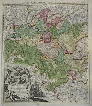
Circuli Franconiae Pars Occidentalis, exhibens fimul integrum fer� Electoratum Moguntinum Tractus Totius Moeni Fluminis. -
Published by N�rnberg: Homann, um., 1720
Art / Print / Poster
Altkolorierter Kupferstich, 55 x 48 cm (hoch) Bildgr��e, 59,5 x 51,5 cm Blattgr��e. Die Karte in altem Fl�chenkolorit zeigt mittig Darmstadt, im Norden Marburg und im S�den Stuttgart. In der linken unteren Ecke eine gro�e Kartusche mit dem Titel, zwei Portraits und lebhafter fig�rlicher Staffage. �ber der Karte zwei Zeilen Text: Unterer und Mindere Theil des gantzen Hochl�blichen Fr�nckischen Craisses, mit welchem zugleich das Ertz-Stift und Chur F�rstentum Maintz sampt denen noch �brige Fr�nck. Staaten als da seind die Grafsch. Wertheim, Rheineck und Erpach nebst den angrentzenden Nideren Chur Pfaltz am Rhein in dieser Tafel angezeigt werden.- Johann Baptiste Homann 1663 - 1724, Kupferstecher und Verleger in N�rnberg. - Einige wenige kleine Einrisse, zum Teil hinterklebt. Leuchtendes Altkolorit und kraftvoller Druck, ein sch�nes Blatt.
-
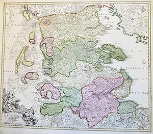
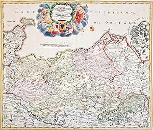
Ducatus Slesvicensis in omnes ejusdem Generalies et Particulares Praefecturas exacte divisi. -
Published by N�rnberg: Homann [um ]., 1720
Art / Print / Poster
Altkolorierter Kupferstich 48,5 x 56,5 cm, Blattgr��e 53,5 x 61,5 cm. Das Herzogtum Schleswig in seiner ganzen Ausdehnung von Hadersleben im Norden bis zum Eiderlauf im S�den. In der linken unteren Ecke die Titelkartusche mit Figurenschmuck. Die �mter des Herzogtums fl�chig in leuchtende Altkolorit, die weiteren L�ndereien grenzkoloriert. Einige Ortsnamen von alter Hand unterstrichen. - Johann Baptiste Homann 1664-1724, Kartograph und Verleger in N�rnberg. - Das Blatt von guter Erhaltung, die Farben leuchtend, der Druck klar und kraftvoll.
-
Circulus Saxoniae Inferioris in Omnes Suos Status et Principatus Accurate Divisus.
Published by Norimberg� [N�rnberg] , 1702 - 1715
Seller: BALAGU� LLIBRER�A ANTIQU�RIA, Santa Coloma de Farners, GIRON, Spain
Seller Rating:
Map
Sin Encuadernar. Condition: Papel Algo Cansado. Con anotaciones manuscritas de �poca en los m�rgenes. Coloreado a mano de �poca. Size: 61 x 54 Cm.
-
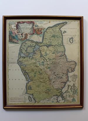
Tabula Generalis Iutiae.
Kobberstukket kort over Jylland (N�rrejylland nord for Konge�en). N�rnberg c. 1720. Lysm�l: 57 x 49,5 cm. Med pladerande. Smuk samtidig h�ndkolorering. Med stor allegorisk titelkartouche. Indrammet i elegant nyere ramme af r�dbrune tr�lister med guldkant.(Grafik/Prints). (Landkort/Maps). * Dekorativt kort over Jylland fra Konge�en til Skagen med L�s� og Sams� samt det nordvestlige hj�rne af Fyn. Kartouchen oplyser, at N�rrejylland omfatter Aalborg, Viborg, Ribe og Aarhus Stift.
-
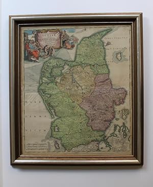
Tabula Generalis Iutiae.
Kobberstukket kort over Jylland (N�rrejylland nord for Konge�en). N�rnberg c. 1720. Lysm�l: 57 x 49,5 cm. Med pladerande. Smuk samtidig h�ndkolorering. Med stor allegorisk titelkartouche. Indrammet i elegant nyere ramme af fors�lvede tr�lister.(Grafik/Prints). (Landkort/Maps). * Dekorativt kort over Jylland fra Konge�en til Skagen med L�s� og Sams� samt det nordvestlige hj�rne af Fyn. Kartouchen oplyser, at N�rrejylland omfatter Aalborg, Viborg, Ribe og Aarhus Stift.
-
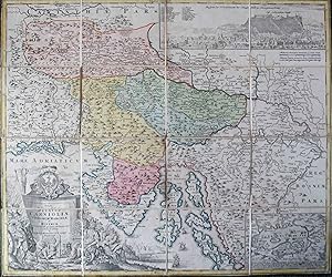
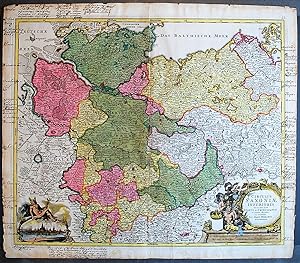
Tabula Ducatus Carnioliae Vindorum Marchiae et Histriae
Published by Nuremberg c. 1750, Nuremberg, 1750
Seller: High Ridge Books, Inc. - ABAA, South Deerfield, MA, U.S.A.
Association Member: ABAA ESA ILAB SNEAB
Seller Rating:
Folding map, dissected and backed with linen with contemporary slipcase. This map, after L. B. Valvasor, shows current-day Slovenia. Inset view of Ljubljana, map of Lake Cerknica. Uncolored decorative cartouche. The slipcase, a feature not often seen in 18th century maps such as this, is in very good condition with some rubbing at edges.
-
Norimbergae, I. Bapt. Homanno, s.a. (hacia 1740), mapa de 46'5 x 57 cm., en colores.
-
![Seller image for [MAP OF DENMARK] Regni Daniae in quo sunt Ducatus Holsatia et Slesvicum Insul� Danic� Provinci� Iutia Scania Blekingia nova Tabula a edita � Io. Baptista Homanno Noribergae, et aucta Secundum Geographiam vovisimam, Iohann H�b for sale by Antiquariaat Arine van der Steur / ILAB](https://pictures.abebooks.com/inventory/md/md21804600558.jpg)
[MAP OF DENMARK] Regni Daniae in quo sunt Ducatus Holsatia et Slesvicum Insul� Danic� Provinci� Iutia Scania Blekingia nova Tabula a edita � Io. Baptista Homanno Noribergae, et aucta Secundum Geographiam vovisimam, Iohann H�b
Seller: Antiquariaat Arine van der Steur / ILAB, Den Haag, Netherlands
Seller Rating:
Nuremberg, H�bner, 1710. One sheet. Ink on paper. Copper engraving. Hand coloured. One fold. Faded stain in the right and left margin, margins frayed and reinforced. 523x631 mm. Map of Denmark and part of Gemany and Sweden. Edition with the name Iohann H�bneri on the title and 'Cum Privilegio' just below the title.
-
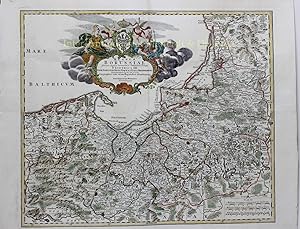
FINE MAP OF POLAND AND KALININGRAD "Regnum Borussiae Gloriosis auspicys Serenissimi et Potentissimi Princip Friderich III
Seller: Inter-Antiquariaat Mefferdt & De Jonge, Amsterdam, Netherlands
Seller Rating:
Art / Print / Poster
FINE MAP OF POLAND AND KALININGRAD "Regnum Borussiae Gloriosis auspicys Serenissimi et Potentissimi Princip Friderich III." Copper engraving published around 1710 by Johann Baptist Homann in Nuremberg. Coloured by a later hand. Size: 48,3 x 57,2 cm Beautiful map of the Baltic coast consisting of northern Poland (former Prussia), K�nigsberg (nowadays Kaliningrad), and parts of Lithuania. It includes the major cities of Danzig (Gda'sk), Elbing (Elblag), Mari�nburg (Malbork), Heilsberg (Lidzbark Warmi'ski), and Culm (Che'mno). Mountains and forests are rendered in profile following Homann s typical stylistic conventions. An elaborate decorative cartouche bearing numerous allegorical elements fills the Baltic Sea at the top center. The cartouche celebrates the K�nigsberg assentation of Frederick III of Brandenburg, who crowned himself King of Prussia on January 18, 1701. While Frederick, now the Frederick I of Prussia, had an uneventful reign, his grandson, Frederick the Great would eventually consolidate this region into Brandenburg-Prussia. This area was returned to a reconstituted Poland by the Treaty of Versailles following World War II. Price: Euro 475,-.
-
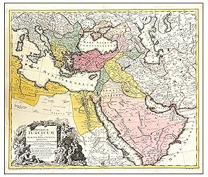
IMPERIUM TURCICUM IN EUROPA, ASIA ET AFRICA REGIONES
Published by N�remberg,Nuremberg, 1737
Seller: LIBRERIA ANTICUARIA MARGARITA DE DIOS, MADRID, Spain
Association Member: LANCE
Seller Rating:
Condition: Bien. Materia: Mapa antiguo del siglo XVIII. Imperio otomano. Publicaci�n: N�remberg, 1737 Descripci�n: Magn�fico mapa del Imperio Otomano, que se extiende desde el Golfo P�rsico y el Mar Rojo hasta el mar Mediterr�neo y Caspio Excelente detalle y atractiva cartela. Dimensiones: 540 x 620 mm. T�cnica:Grabado calcogr�fico. Coloreado a mano con acuarela en la �poca. Conservaci�n:Buen estado. Impreso en papel fuerte y de gran calidad. RES1.