Order Total (1 Item Items):
Shipping Destination:

Johannes Van Keulen (116 results)
Skip to main search results
Product Type
- All Product Types
- Books (52)
- Magazines & Periodicals
- Comics
- Sheet Music
- Art, Prints & Posters (21)
- Photographs
- Maps (43)
-
Manuscripts &
Paper Collectibles
Condition
Binding
Collectible Attributes
- First Edition (4)
- Signed
- Dust Jacket
- Seller-Supplied Images (94)
- Not Printed On Demand (115)
Free Shipping
Seller Location
Seller Rating
-
![Seller image for Verhandeling der zee-horenkens en zee-gewassen in en omtrent Amboina en de nabygelegen eilanden, [LeatherBound] for sale by True World of Books](https://pictures.abebooks.com/inventory/md/md31533062685.jpg)
LeatherBound. Condition: New. LeatherBound edition. Condition: New. Reprinted from 1754 edition. Leather Binding on Spine and Corners with Golden leaf printing on spine. Bound in genuine leather with Satin ribbon page markers and Spine with raised gilt bands. A perfect gift for your loved ones. NO changes have been made to the original text. This is NOT a retyped or an ocr'd reprint. Illustrations, Index, if any, are included in black and white. Each page is checked manually before printing. As this print on demand book is reprinted from a very old book, there could be some missing or flawed pages, but we always try to make the book as complete as possible. Fold-outs, if any, are not part of the book. If the original book was published in multiple volumes then this reprint is of only one volume, not the whole set. Sewing binding for longer life, where the book block is actually sewn (smythe sewn/section sewn) with thread before binding which results in a more durable type of binding. Pages: 124 Language: Dutch.
-

Linee di costa: La cote d'Espagne de Malgue jusques ? Modril.
Published by Francia,, 1735
Seller: libreria antiquaria perini Sas di Perini, Verona, VR, Italy
Seller Rating:

Art / Print / Poster
Silografia di mm 90x240. Buon esemplare, con bruniture, tracce di umidit? e margini frastagliati.
-
Linee di costa: aussi de Barbarie jusques ? l'Isle de Tabarque, les cotes entre le Cap St. Martin & le Cap Creos.
Published by Amsterdam,, 1700
Seller: libreria antiquaria perini Sas di Perini, Verona, VR, Italy
Seller Rating:
Art / Print / Poster
Silografia intervalla a testo per uno specchio di stampa complessivo di mm 185x240. Ben conservato, con bruniture e tracce di umidit?.
-

De grootie nieuwe vermeerderde Zee-Atlas ofte Water-Werelt: vertoonende in sigh alle de Zee-Kusten des Aardtryks. Reprint der Ausgabe Amsterdam 1685. Ein Meilenstein der See-Kartographie. Mit einem Vorwort von Imre Josef Demhardt und einer �bersetzung der niederl�ndischen Einleitung von Sigrid Barthel. Karten und Originaltexte sind auf etwa 88% verkleinert. Faksimiletext niederl�ndisch, Einleitung deutsch. Der Nachdruck macht ein Prachtwerk der niederl�ndischen Seekarten des ausgehenden 17. Jahrhunderts zug�nglich, das auch ein beredtes Zeugnis seiner Zeit darstellt. Die wirtschaftliche und kulturelle Dynamik der niederl�ndischen Provinzen Spaniens lie�en deren b�rgerlich-protestantischen Freiheitskampf erfolgreich enden und in das "goldene Zeitalter" der republikanischen Generalstaaten einm�nden. Bis ins 18. Jahrhundert waren deren handeis- und kunstsinnige B�rger f�hrend im Seehandel und damit auch in der Kartenkunst, mit Amsterdam als dem bedeutendsten Zentrum der nautischen Kartographie. Auf 555 Exemplare limitierte Lederausgabe. 104 Seiten mit 88 farbigen Faksimiletafeln, Gro�format 50 x 29 cm, Leder in Schuber (Wissenschaftliche Buchgesellschaft 2008) leichte Lagerspuren, Schuber besch�digt 2725 g. Sprache: de, nl.
-
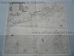
No Binding. Condition: Very Good. The New Sea Map of the First Part of the Channell betwext England et France. Engraved map with original hand colouring; an elaborate strapwork cartouche with the map title in Dutch, French, English, Spanish & Italian; a compass rose and numerous rhumb lines. It is unusually oriented to the West. The map in fact covers the Channel from the Pas de Calais almost as far as Bayeux in Western Normandy and on the English side from Dover almost as far as Selsey Bill. On the English coast towns shown from Dover Westward include Hythe, Rye, Hastings, Brighton, Shoreham and Middleton and many more. On the French side the towns marked include Calais, Montreuil, St Valery, Dieppe, Le Havre, the Seine (as far as Rouen), Caen and Port-en-Bessin. This particular chart of the eastern Channel appears to be very uncommon and currently Internet searches have found only one copy for sale at 495! The map is printed on three conjoined sheets of heavy paper and is in a strong and excellent state. The margins are very wide. 515 x 620 mm. 52 x 62 cm.
-
Linee di costa: Isles d'Yvique, Majorque & Minorque, les cotes entre le Cap St. Martin & le Cap Creos.
Published by Amsterdam,, 1700
Seller: libreria antiquaria perini Sas di Perini, Verona, VR, Italy
Seller Rating:
Art / Print / Poster
Silografia intervalla a testo per uno specchio di stampa complessivo di mm 380x240. Raffigura le coste delle Baleari e della Catalogna. Ben conservato, con bruniture e tracce di umidit?.
-
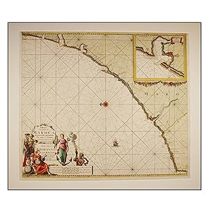
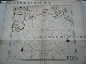
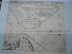
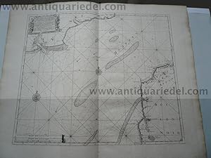
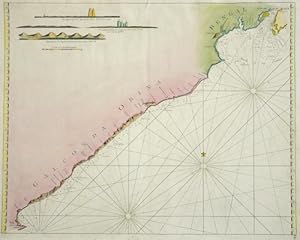
Paskaart Van de Kust van Maroca Beginnende van Larache tot aan C. Cantin Met syn Diepte en Droogte dus ver Naaukerig Opgestelt en Verbetert.
Published by Amsterdam:, 1681
Seller: Robert Frew Ltd. ABA ILAB, London, United Kingdom
Association Member: ABA ILAB PBFA
Seller Rating:
Map
50.5 x 58 cm. Uncoloured. Double page chart of the central coastline of Morocco orientated with north to the left edge. Inset plan of the bay at Sale and Rabat. Chart with rhumb lines, compass roses and an illustration of a ship to the sea. Some spots scattered across image. Some light offsetting, lightly browned overall. Small section reinforced on verso at centrefold.
-
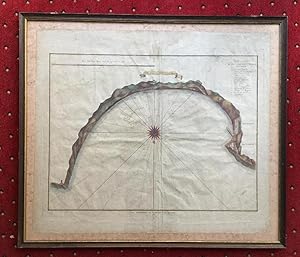
De Baay van Tanger. Te Amsterdam by G. Hulst van Keulen. Zeigt Bucht mit Windrose, nautische Angaben, oben links Legende a-n.
Published by Amsterdam, Gerard Hulst van Keulen., 1781
Art / Print / Poster
Kupferstich altkoloriert. 45 x 59 cm (Plattengr��e), unter Glas gerahmt, im oberen Bug schwacher Feuchtigkeitsrand, schlichte dekorative Karte, Johannes van Keulen - 1678-1704 t�tig in Amsterdam als Kartenverleger, publizierte 'De Groote nieuwe Zee-Atlas' erstmals 1680, dieser wurde in den folgenden Auflagen (ab 1687) auf 5 B�nde erweitert.--- In 1678, Johannes registered with the Amsterdam Booksellers Guild as a "bookseller and Cross-staff maker" By this time, most of the Amsterdam chart makers and instrument makers, like Blaeu, Janssonius, Hondius, Goos, and Doncker, had either closed down or were at the end of their fame. As a result, Johannes van Keulen had the opportunity to obtain copperplates, privileges, and stocks of many of his former competitors. Besides manuals and cross-staffs, Johannes produced his famed 'ZeeAtlas' (Sea Atlas, 5 volumes), and 'ZeeFakkel' (Sea pilotbook, 5 volumes).- Gerard Hulst van Keulen, (1733-1801) was the great-grandchild of the founder Johannes.- Sprache: Niederl�ndisch. * * * * --- due to EPR-Restrictions NO SHIPPING to Bulgaria, Danmark, Greece, Luxembourg, Poland, Romania, Sweden, Slovakia and Spain --- * * * *.
-
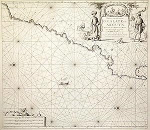
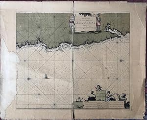
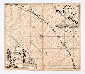
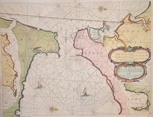
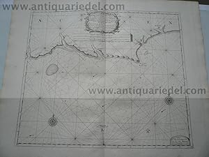
Paskaart van de Kuste van Gualate en Arguyn. Beginnende van C. Bajador to C. Blanco Seer Nau-keurigh op-gestelt.
Published by Amsterdam:, 1681
Seller: Robert Frew Ltd. ABA ILAB, London, United Kingdom
Association Member: ABA ILAB PBFA
Seller Rating:
Map
50.1 x 56.9 cm. Uncoloured. Double page chart showing the coastline of what is now Western Sahara orientated with north to the left edge. Ornate title cartouche to upper right corner featuring two costumed figures in Arab dress, in the background a horseman and a camel. The cartouche also bears a vignette illustration of hunting scene. The chart with rhumb lines, compass roses and an illustration of a dhow to the sea. Neat repair at lower edge of centrefold. Two small brown marks to lower left corner, otherwise in very good condition.
-
Hardcover. Condition: very good. White Sea/Kola, map anno 1715, J. van Keulen Coppermap, edited by J. van Keulen, anno 1715, "Paskaart van de Mont van de WITTE ZEE.", size of the leaf: 53x60 cm., minor cracs on margins, little brownish.
-
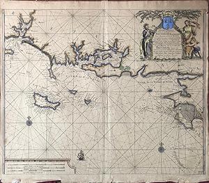
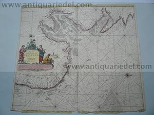
Nieuewe Pascaart Van de Zeekusten Van Bretangne Beginnende Van t' Incoomen Van de Rivier de Loire tot dan t' Eylandt de Groa door Vooght Geometra. (Also titled in French:) Carte Marine de la Costes de Bretangne depuis la Commancement de la Rivierre de Loire Jus'quia Isle de Groa Pr Vooght Geometra.
Published by Amsterdam: Van Keulen, [c.1728]., 1728
Seller: William Matthews/The Haunted Bookshop, Sidney, BC, Canada
Seller Rating:

A copper engraved map on laid paper, large colour cartouche at top right containing a coat-of-arms, with text in Dutch and French. Map is hand-coloured. Also a small sailing ship and two compass roses. Imprint in cartouche: "t' Amsterdam by Johannes van Ceulen, Boekverkooper Aand Nieuwenbrugh Met Privilegie Voor 15 Iaar" and in French: "d'Amsterdam Chez Iean Van Ceulen Vendeur des Cartes Marines Vis a' Vis du Pont Neuf". Small number "22&1/2" printed in lower right corner. Plate size is 60cm x 49cm, on a sheet measuring 62cm x 54cm. Verso blank. An attractive map with a handsomely coloured cartouche. From Van Keulen's "De Nieuwe Groote Ligtende Zee-Fakkel." [1728 - many editions]. The cartouche attributes the map to Claes Jansz Vooght; the art in the cartouche may be by Jan Luyken, as he illustrated Van Keulen's Atlas. A map of the coast of France, Brittany and the coast near the mouth of the Loire River.
-
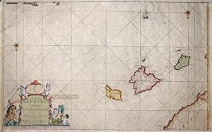
Paskaart, voor een Gedeelte der Kust van, Barbaria, van C. Ivi, tot Bona. En de Kust van, Catalonia.Eylanden, Yvica, Majorca, en Minorca
Published by Artist: Keulen Johannes van ( - 1715 ) Amsterdam; issued in: Amsterdam; Keulen Johannes van ( 1654 - 1715 ) Amsterdam; Johannes van Keulen (1654 - 1715) was a 17th-century Dutch cartographer He published the influential nautical atlas the Zee-Atlas and the pilot guide Zee-Fakkel In 1678 Johannes van Keulen established himself in Amsterdam and in 1680 he obtained a patent from the States of Holland and West Friesland allowing him to print and publish maritime atlases and shipping guides These were books of maps and descriptions of itineraries used by helmsmen for safe navigation The patent was a kind of protection against illegal copying of produced books and charts This was especially important for the atlases which were made with extensive, 1654
Seller: Antique Sommer& Sapunaru KG, M�nchen, Germany
Seller Rating:
Technic: Copper print; colorit: colored; condition: Upper and lower margin cutted, missing part!; size (in cm): 36 x 58; Part of the map from van Keulen of the coast of Catalonia, Majorca, Minorca, Ibiza and part of the Barbary coast. History: The indigenous population of the Balearic Islands probably immigrated from the Iberian Peninsula or today's southern France. In ancient times, the islands were called Balearides or Gymnesiae, which meant the islands of Mallorca (Balearis major) and Menorca (Balearis minor). At first they were dependent on the Phoenicians. Mallorca and Ibiza were conquered in 1229 and 1235 respectively by Jacob I of Aragon (Catalan Jaume I), Menorca by his descendant Alfonso III. The Balearic Islands, like Catalonia, now belonged to the Aragon Crown. At times, together with parts of Catalonia, they formed an independent state, the Kingdom of Mallorca, ruled by a branch of the Aragonese royal family. In 1708 Ma� was conquered by the British. The Peace of Utrecht (1713), which ended the War of Spanish Succession, gave Menorca to the British Empire. This had to return the island to Spain in the Treaty of Versailles (1783), but remained British until 1802. The Spanish province of the Balearic Islands was founded in 1833.
-
De Nieuve Groote Ligtende Zee-Fakkel.
Published by 1969-1970, 1969
Seller: Berkelouw Rare Books, Berrima, NSW, Australia
Association Member: ANZAAB ILAB
Seller Rating:
Amsterdam 1716-1753. Reprinted, New York: Da Capo Press & Amsterdam: Theatrum Orbis Terrarum, (1969-1970). 6 parts in 3 vols. Elephant folio. Orig. cloth. Gilt. Spines uniformly gilt with raised bands and morocco titling-labels (slightly rubbed). With illusts., fold. map & charts some of which are coloured. Peel marks on end-papers. Complete and as new, albeit ex-library with stamps on edge of text-block. Lim. ed. of 500 numbered sets.
-
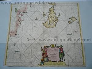
Scotland/Westcoast, anno 1712, J. van Keulen map, coloured
Published by Keulen Johannes van 1654-1715, 1712
Map
Kein Einband. Condition: Befriedigend. Copperengraving, edited by J. van Keulen "Pascaert vande westkust van SCHOTLANT, als mede een gedeelte van de Lewys Eylanden, van S. Patricius.", coloured, size: 505x564 mm., some minor cracs on margins, Amsterdam, anno 1712.
-
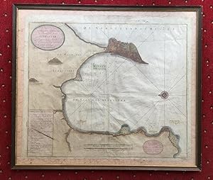
Nieuwe en seer nette Caart van de Baay en Stadt GIBRALTAR. Geteckent door den Wel Ed. Hr. H. Leynslager Cap. in't Edel Moogende Collegie ter Admiraliteyt alhier. -- Niederl�ndische Seekarte der Bucht von Gibraltar - westorientiert - mit Windrose, nautischen Linien, Sandb�nken mit Tiefenangaben. 2 Kartuschen sowie Legende A-L und Meilenzeiger deutsch und franz�sisch. Gibraltar, die K�stenlinie sowie einige markante Punkte mehrfarbig koloriert.
Published by Amsterdam, Johannes van Keulen, []., 1695
Art / Print / Poster
Kupferstich altkoloriert. 54 x 63 cm (Blattgr��e), unter Glas gerahmt, leichte Mittelfalte etwas knittrig, kleinere Randl�suren, Rahmen etwas bestossen, Verlagskartusche: 'Tot Amsterdam by Joannes van Keulen Beekverkooper aan de Nieuwebrug inde Gekroonde Lootsman'.-- Johannes van Keulen - 1678-1704 t�tig Kartenverleger in Amsterdam, publizierte 'De Groote nieuwe Zee-Atlas' erstmals 1680 und wurde in den folgenden Auflagen auf 5 B�nde (von 1687 ab) erweitert.-- In 1678, Johannes registered with the Amsterdam Booksellers Guild as a "bookseller and Cross-staff maker" By this time, most of the Amsterdam chart makers and instrument makers, like Blaeu, Janssonius, Hondius, Goos, and Doncker, had either closed down or were at the end of their fame. As a result, Johannes van Keulen had the opportunity to obtain copperplates, privileges, and stocks of many of his former competitors. Besides manuals and cross-staffs, Johannes produced his famed 'ZeeAtlas' (Sea Atlas, 5 volumes), and 'ZeeFakkel' (Sea pilotbook, 5 volumes).- Sprache: Niederl�ndisch. * * * * --- due to EPR-Restrictions NO SHIPPING to Bulgaria, Danmark, Greece, Luxembourg, Poland, Romania, Sweden, Slovakia and Spain --- * * * *.
-
PASKAART VAN DE KUST VAN MAROCA BEGINNENDE VAN LARACHE TOT AAN C. CANTIN MET SYN DIEPTE EN DROOGTE DUS VER NAAUKERIG OPGESTELT EN VERBETERT
Published by Amsterdam, 1690
Seller: LIBRERIA ANTICUARIA MARGARITA DE DIOS, MADRID, Spain
Association Member: LANCE
Seller Rating:
Condition: Bien. Materia: Carta nautica del siglo XVII. Marruecos. Larache. Publicaci�n: Amsterdam, Van Keulen, c.1690. Descripci�n: Carta n�utica de la costa central de Marruecos con un plano insertado en el margen superior izquierdo de la bah�a de Rabat, un barco surcando los mares, Rosa de los vientos y gran cartela con titulo y longitudes. Medidas: 585x 510 mm. (in) 610 x 540 mm. (ex.) T�cnica:Grabado calcogr�fico. Precioso coloreado de �poca. Conservaci�n: Buen estado, reforzado en la trasera con papel. RBS1.
-
Linee di costa: isole Baleari, Spagna.
Published by Francia,, 1735
Seller: libreria antiquaria perini Sas di Perini, Verona, VR, Italy
Seller Rating:
Art / Print / Poster
Incisione in rame, 410x540. Raffigura le coste di Maiorca, Ibiza, Formentera e Catalogna. Ben conservato, carta ingiallita.
-
Pas-Kaart, Van de Zee-Kusten, van, Brazilia, Tusschen, Punto de Lucena en Cabo S. Augustino. Door Vooght, Geometra.
Published by Amsterdam: Van Keulen, [c.1728]., 1728
Seller: William Matthews/The Haunted Bookshop, Sidney, BC, Canada
Seller Rating:
A copper engraved map on laid paper, large colour cartouches at top and bottom, map hand-coloured. Also a small sailing ship and two compass roses (North is indicated to the right of the map). Imprint in lower cartouche: 't Amsterdam, By, Iohannis Van Keulen, Boek en Zee-Kaart verkooper, aan de Niewe-brugh. Small number "13" printed in lower right corner. Plate size is 60cm x 51cm, on a sheet measuring 75cm x 61cm. Verso blank. Old stain to left side extending slightly into plate, yellow remains of old tape repairs to fold on verso, splitting along fold, tears to margins, otherwise generally very good. An attractive map with handsomely coloured cartouches. From Van Keulen's "De Nieuwe Groote Ligtende Zee-Fakkel." [1728 - many editions]. The map is by Claes Jansz Vooght; cartouche art may be by Jan Luyken, who illustrated Van Keulen's Atlas. A map of the East coast of Brazil. The upper cartouche depicts natives with weapons: a sword & shield and a bow; the lower cartouche depicts a mermaid, a sea god, and mermen, one of whom holds a Jacob's staff.
-
De nieuwe groote ligtende zee-fakkel: Amsterdam 1716-1753 (2 volumes)
Published by Amsterdam : Theatrum Orbis Terrarum, 1969
Book
Condition: Good. 2 (of 3) uniform gilt lettered brown leatherette volumes, (foldanle) maps in b/w, large folio. Limited edition of 500 numbered copies, however, this is an unnumbered copy.; Edges covers lsightly worn.
-
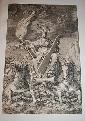
De Nieuwe Groote Lichtende Zee-Fakkel.FRONTISPIECE. Sea Goddess with Sea Torch. From First Edition.
Published by Johannes van Keulen, 1681-1684., Amsterdam:, 1681
From first edition. Very rare. Fantastic frontispiece. Trimmed just outside of border. Mounted on larger plain leaf. Privilege text is on verso. Suitable for framing, or perhaps mating with another copy. Dramatic frontispiece from Part IV of Keulen?s Zee-Fakkel, or ?Sea Torch? Illustrates a sea-goddess representing navigation and trade, with an armillary sphere as a head piece, in a shell chariot pulled by two sea-horses. She holds a rudder and a torch signifying the guidance by the atlas of the charts. Artist is Jan Luyken. Johannes van Keulen (1654-1715), Dutch bookseller and cartographer, publisher of the influential nautical works Zee-Atlas and the pilot guide Zee-Fakkel. The Zee-Fakkel was published in 5 volumes between 1681 and 1684, with over 130 new charts/maps by Claes Jansz Vooght and illustrations by Jan Luyken. The work made Keulen famous. Complete copies of the Zee-Fakkel, when on the market, fetch high six figures, monetarily. Citations: Keulen Cartography: 195-204. Amsterdam Museum: A51379.
-
De Groote nieuwe vermeerderede Zee-Atlas ofte Water-Waereld. Frontispiece only. Very rare. Single leaf.
Published by [Gerard van Keulen,] [1708]., [Amsterdam:], 1708
Original frontispiece to the van Kuelen masterpiece sea-atlas De Groote Nieuwe Vermeerderede Zee-Atlas ofte Water-Waereld. Vertoonende in zig alle de Zee-kusten des Aardryks. [Amsterdam, 1708]. Leaf has been adhered at corners to another sheet. Trimmed at border line with some minor edge wear and soiling. Beautiful illustration and most suitable for framing. We find only one copy in reference, which was sold at Christie?s UK for over $200,000.00 at auction in May, 2022. The frontispiece is a match at all points, though trimmed and uncolored [the Christie?s copy full and in color]. ?The most complete sea-atlas by the Van Keulens, composed of nearly all the charts published up to the date 1709? [-Koeman].?The firm of van Keulen, active continuously from 1678 to 1885, was the largest private hydrographic chart-publishing agency in the world. Three generations of the family were active during the period when Amsterdam was at its height as a mercantile and shipping power. As a by-product of this, Amsterdam became the leading European centre of marine cartography, densely populated with the best chart-makers and publishers. Pre-eminent among these firms were the van Keulens who produced ?the largest and finest marine atlases in Holland? (Koeman). ?Johannes van Keulen (1654-1711) was the founder of the firm, enrolling in the booksellers? guild in Amsterdam in 1678. In 1680 he published the first part of his Zee-Atlas, by which the reputation of the firm was established. Although the family business was closely tied to maritime publications, Johannes himself was not a chart-maker, but simply an interested publisher. He was fortunate that, from the outset, he employed the skilled surveyor Claes Janszoon Vooght, who actually prepared the charts and also wrote the text. Over the years the Zee-Atlas was expanded to five parts, and it continued in print, in one form or another, until 1734. More ambitious, and with a far longer and more complicated history, was his pilot book, the Zee-Fakkel, which was first published in 1681-82, and continued in print to about 1800. The family also published books on every aspect of geography, navigation and nautical matters. Johannes?s son Gerard (c. 1678-1727) gradually succeeded him from about 1704. In contrast to his father, Gerard was a talented engraver, mathematician, and chart-maker, whose abilities were recognised when he was appointed Hydrographer to the Dutch East India Company in 1714. Under his guidance, the Zee-Atlas and Zee-Fakkel were greatly revised and improved, and many new charts introduced. After Gerard?s relatively early death in 1727, he was succeeded by his widow and later by his son Johannes II who is known in particular for publishing the sixth volume of the Zee-Fakkel ? this volume contained the previously secret cartography of the East India Archipelago.? [Christie?s lot 8, May 24, 2022].
-
Mer du Nord Europe. England, Hull, anno 1715, Van Keulen map-scarce
Published by Keulen Johannes van 1654-1715, 1715
Map
Kein Einband. Condition: Befriedigend. East-England/anno 1715, map, van Keulen Coppermap, edited by J. van Keulen, anno 1715, "Pas-caert Vande Zee-custen van ENGELAND.", old colours, some cracs on margins, more on below margin, size of the leaf: 52x59 cm.
-
Kein Einband. Condition: Befriedigend. Nordfriesland/J�tland, anno 1715, Van Keulen, Karte "Paskaart vande West Kust van Jutland Van Busem tot aent Jutsche Riff." Seekarte ver�ffentlicht bei Van Keulen, anno 1715, mit der Westk�ste von Schleswig-Holstein und D�nemark mit den Nordfriesischen Inseln. Blattma�: 53x60 cm., guter Erhaltungszustand.
-
Jutland/North Frisian Islands, anno 1715, Van Keulen, map
Published by Keulen Johannes van 1654-1715, 1715
Hardcover. Condition: very good. "Paskaart vande West Kust van Jutland Van Busem tot aent Jutsche Riff." Seekarte ver�ffentlicht bei Van Keulen, anno 1715, mit der Westk�ste von Schleswig-Holstein und D�nemark mit den Nordfriesischen Inseln. Blattma�: 53x60 cm., guter Erhaltungszustand.
-
Hardcover. Condition: very good. Channel/Dover/Calais, anno 1715 J.van Keulen map Channel/Dover/Calais, anno 1715 J.van Keulen map Coppermap, edited by J. van Keulen, anno 1715, printed on thick paper, good image, wide margins, size of the leaf: 62x74 cm.
-
Cust van Hispangien"
Published by Artist: Keulen Johannes van ( - 1715 ) Amsterdam; issued in: Amsterdam; Keulen Johannes van ( 1654 - 1715 ) Amsterdam; Johannes van Keulen (1654 - 1715) was a 17th-century Dutch cartographer He published the influential nautical atlas the Zee-Atlas and the pilot guide Zee-Fakkel In 1678 Johannes van Keulen established himself in Amsterdam and in 1680 he obtained a patent from the States of Holland and West Friesland allowing him to print and publish maritime atlases and shipping guides These were books of maps and descriptions of itineraries used by helmsmen for safe navigation The patent was a kind of protection against illegal copying of produced books and charts This was especially important for the atlases which were made with extensive, 1654
Seller: Antique Sommer& Sapunaru KG, M�nchen, Germany
Seller Rating:
Map
Technic: Copper print; colorit: colored; condition: Very good; size (in cm): 39 x 52; chart of the Strait of Gibraltar. History: Numerous paleoanthropological finds, for example from the Arago cave near Perpignan, prove that Homo erectus already lived in the Mediterranean. In the period of several hundred thousand years, the polar ice caps repeatedly expanded, glaciers covered the high mountains during the ice ages. The sea level was therefore temporarily up to 150 meters below today's level. The Strait of Gibraltar temporarily closed. The Stone Age replaced the Stone Age in different regions. Copper spreads first, then bronze. Spain, rich in metals, began around 2300 BC. The Bronze Age (El Argar culture). Numerous fortified settlements were created. The first states emerged with the Pharaoh dynasties around 3000 BC. BC in Egypt. Almost simultaneously, the first city-states were formed on the Levant and Aegean coasts. The great empires of the early days of Assyria, Babylonia and the Hittites - temporarily expanded into the Mediterranean area. Since the archaic period, i.e. from 800 BC BC, ancient Greece also emerged as a trading power and increasingly created competition for the Phoenicians. The Greeks settled as far as the Rh�ne (Massilia) and the Crimea and set up offices and factories as far as Egypt. Tuscany was the settlement area of the Etruscans, who also controlled the rich iron deposits of Elba. This culture developed from the local Villanova culture, later under strong Greek and Syrian ("oriental") influence. In Rome, the founding of Rome began with the slow but steady rise of the Romans, which began around 500 BC. BC finally emancipated from the Etruscans and founded the republic. The south of the Apennine Peninsula was characterized by the Greek colonies ("Magna Graecia"). At the same time, the Persian empire extended to Egypt and the Bosphorus, subjugating the Phoenicians and the Egyptians. The period of great Persian expansion coincided with the blossoming of Greece, which was able to ward off the Persian invasions in several battles. While the Greeks colonized large parts of the northern Mediterranean coast, the Phoenicians - after (Tire) had lost their independence - built Carthage in North Africa as a new power base and also established commercial branches in Spain (Cadiz), Morocco, Corsica and Sardinia. Sicily was contested between the great powers at that time because of its rich resources and location. In late antiquity, the slow Christianization of the Roman state began, which should have far-reaching consequences, such as the rejection of paganism. The late Middle Ages were characterized by a sustained upswing in the Italian area. Especially the Republic of Venice. The most important naval powers of the early modern period continued to be Venice and Genoa, which dominated trade with the Arab world and thus to Southeast Asia. They also had numerous colonies in the eastern Mediterranean. The War of the Spanish Succession brought about a reorganization of the western and central Mediterranean region in 1713. The French expansion was initially stopped, Spain was reduced to the mainland and the Balearic Islands and the Italian area was redistributed among the rulers. The winner was above all the Habsburg-Austrian line, which also won southern Italy, Sicily, Sardinia and Milan. However, this situation did not last long: the Spanish-Bourbon royal family soon regained control of the Italian territory. Most of the Maghreb were now ruled by Berber tribes, which were beyond the control of the Ottoman Empire but neglected the economy. Morocco and Algeria were marginalized economically, which invited the Spaniards to invasions. The Ceuta and Melilla bases are still under Spanish control.
-
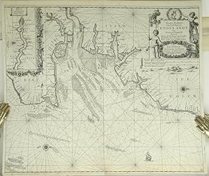
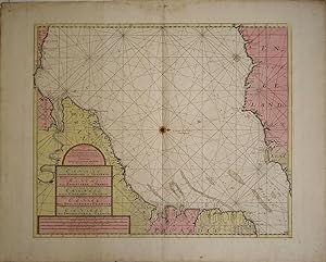
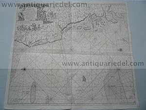
Paskaert Van d'Oost Kust van Engelandt van Dover tot Dunwich Als mede de Toems off de Rivier van Londen Met alle hunne Diepte en Drooghte op het Nieuws Over sien en van veel fouten verbetert.
Published by Amsterdam:, 1681
Seller: Robert Frew Ltd. ABA ILAB, London, United Kingdom
Association Member: ABA ILAB PBFA
Seller Rating:
Map
50.2 x 58.3 cm. Uncoloured. Double page chart of the coastline of south east England orientated with north to the right edge, showing the area from Folkestone through to Southwold. Inset chart of the Thames from the Estuary through to London. The chart with rhumb lines, compass roses, sea depths and an illustration of a ship to the sea. Lower margin narrow though intact, a small section of lower edge restored. Some very light offsetting, otherwise in good condition.
-
Galconda Orixa Bengal
Published by Artist: Keulen Johannes van ( - 1715 ) Amsterdam; issued in: Amsterdam; Keulen Johannes van ( 1654 - 1715 ) Amsterdam; Johannes van Keulen (1654 - 1715) was a 17th-century Dutch cartographer He published the influential nautical atlas the Zee-Atlas and the pilot guide Zee-Fakkel In 1678 Johannes van Keulen established himself in Amsterdam and in 1680 he obtained a patent from the States of Holland and West Friesland allowing him to print and publish maritime atlases and shipping guides These were books of maps and descriptions of itineraries used by helmsmen for safe navigation The patent was a kind of protection against illegal copying of produced books and charts This was especially important for the atlases which were made with extensive, 1654
Seller: Antique Sommer& Sapunaru KG, M�nchen, Germany
Seller Rating:
Technic: Copper print; colorit: original colored; condition: Tear on upper margin perfectly restored; size (in cm): 44,5 x 56; Map depicts the south eastern coast of India with the source of the river Ganges. History: The Coromandel Coast is the southeastern coast region of the Indian Subcontinent, between the Eastern Ghats and the Bay of Bengal of the Indian Ocean. The coastline runs between False Divi Point in the north to Kanyakumari in the south. Its definition can also include the northwestern coast of the island of Sri Lanka. By late 1530 the Coromandel Coast was home to three Portuguese settlements at Nagapattinam, S�o Tom� de Meliapore, and Pulicat. Later, in the 17th and 18th centuries, the Coromandel Coast was the scene of rivalries among European powers for control of the India trade. The British established themselves at Fort St George (Madras) and Masulipatnam, the Dutch at Pulicat, Sadras and Covelong, the French at Pondicherry, Karaikal and Nizampatnam, the Danish in Dansborg at Tharangambadi. Eventually the British won out, although France retained the tiny enclaves of Pondich�ry and Karaikal until 1954. Chinese lacquer goods, including boxes, screens, and chests, became known as "Coromandel" goods in the eighteenth century, because many Chinese exports were consolidated at the Coromandel ports.
-
Hardcover. Condition: very good. Coppermap, edited by J. van Keulen, approx. anno 1715, published in Amsterdam, printed on thick paper, no cracs, very good condition. Size of the leaf: 61x74 cm.
-
Cornwall, map anno 1715, van Keulen
Published by Keulen Johannes van 1654-1715, 1715
Art / Print / Poster
Hardcover. Condition: Gut. Cornwall, map anno 1715, van Keulen Coppermap, edited anno 1715, by van Keulen, size of the leaf: 61x74 cm., some restorations on margins, little brownish.