Order Total (1 Item Items):
Shipping Destination:

Matthias Seutter (111 results)
Skip to main search results
Product Type
- All Product Types
- Books (102)
- Magazines & Periodicals
- Comics
- Sheet Music
- Art, Prints & Posters (5)
- Photographs
- Maps (4)
-
Manuscripts &
Paper Collectibles
Condition
- All Conditions
- New
- Used
Binding
Collectible Attributes
- First Edition (2)
- Signed
- Dust Jacket (1)
- Seller-Supplied Images (107)
- Not Printed On Demand
Seller Location
Seller Rating
-
![Seller image for Maiestas Austriaca sive Circulo Archiducato Austriae cum ceteris Augustissimae huic Domui per Germaniam continuo ferme tractu devotis Haereditariis Terris ob oculos posit. [�sterreich anno 1750]. Landkarten- Faksimile in alter Farbkolorierung. for sale by Galerie Antiquariat Schlegl](https://pictures.abebooks.com/inventory/md/md19510946842.jpg)
Maiestas Austriaca sive Circulo Archiducato Austriae cum ceteris Augustissimae huic Domui per Germaniam continuo ferme tractu devotis Haereditariis Terris ob oculos posit. [�sterreich anno 1750]. Landkarten- Faksimile in alter Farbkolorierung.
Published by Erschienen in Fellbach bei Novo Print ohne Jahre Angabe [1980]., 1980
Map
Sch�ner Faksimile- Nachdruck einer Kupferstich-Karte von Seutter aus Augsburg, um 1750, in alter Kolorierung, links oben Kartusche mit L�nderwappen. Zustand: Guter, kr�ftiger Abdruck, leichte Br�unung, sonst sauber und tadellos erhalten. Sprache: Deutsch Gewicht in Gramm: 1050 Blatt- Gr��e 44 bis 50 cm; Gesamt- Gr��e 60 x 66,8 cm, unter chamois Schr�gschnitt- Passepartout und in sch�tzender Folie eingeschwei�t. Nachdruck mit freundlicher Genehmigung der W�rttembergischen Landesbibliothek.
-
![Seller image for [Portfolio]: Antique Maps of the World in Color for sale by Between the Covers-Rare Books, Inc. ABAA](https://pictures.abebooks.com/inventory/md/md31614799540.jpg)
[Portfolio]: Antique Maps of the World in Color
Published by Sterling Publishing House, Co., Inc, New York, 1960
Seller: Between the Covers-Rare Books, Inc. ABAA, Gloucester City, NJ, U.S.A.
Association Member: ABAA ESA ILAB IOBA
Seller Rating:

First Edition
Unbound. Condition: Very Good. Portfolio. Color facsimiles of 36 historical maps. Each map measures approximately 12" x 9", printed on 17" x 11�" paper with descriptive text in the left margin. Housed with a title page sheet and unprinted top sheet in a four-fold chemise. Unprinted topsheet sunned at the edges, first two leaves with some very light toning and a couple of tiny corner creases; the maps are otherwise bright and fine. The chemise is good only with toning, wear, and soil, and a 1" creased tear on the cover panel. A nice production, and the chemise has done its job, keeping the maps bright and fresh.
-

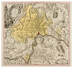
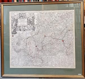
Mappa Geographica, continens Archiepiscopatum et Electoratum Coloniensem Cum Conterminis Ducatibus Iuliacensi Et Montensi nec non Comitatu Mursano. Kupferstich-Karte mit Fl�chenkolorit. Oben rechts Titelkartusche (nicht koloriert) mit 4 Wappen, unten links mit Meilenanzeiger.
Published by (Augsburg), 1750
Book
Hardcover. 50 x 58 cm. (ca. 1750). gerollt, oben in den �u�ersten Ecken mit jeweils einem ca. 2 cm gro�en Fleck, sonst nur minimal stockfleckig.
-
Ditionis pagi Scaphusiani qui confoederatae Helvetiorum reipublicae pars est descriptio geographica nova studio adornata
Published by SEE IMAGES, SEE IMAGES, 1750
Map
Soft cover. Condition: Near Fine. FULL COLOUR SWISS MAP - CIRCA 1750 : regional map centred on Schaffhausen, engraving with original hand-colouring, sheet 530 x 640 mm [ includes margins ]; (20 7/8 x 25 1/4 in), central vertical fold, minor spotting, unframed, [circa 1750]. Fresh Map.
-
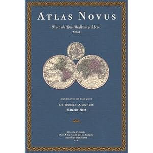
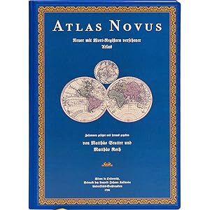
Atlas Novus Indicibus Instructus oder Neuer mit Wort-Registern versehener Atlas Bestehend in 50 Seutterisch-Geographischen Haupt- und Special-Tabellen
Published by Fines Mundi GmbH Saarbr�cken, 2021
Book
Condition: Wie neu. Faksimile-Reprint der Ausgabe Wien 1736. XIV Seiten 2 farbige Titelbl�tter 53 doppelblattgro�e Karten tadellos neuwertig / Als wor�ber erstlich ein sehr nutzlich-compendioser General- nachgehends aber �ber eine jede insonderheit ein solch-bequemer Special-Index gedrucket worden Da� mittelst desselben ein jedwederes, in der darzu geh�rigen Mappa gestochenes Ort, und Wort ohne besondere M�he alsogleich gefunden werden kan. Zusammen gesetzt, und zu bequemen Gebrauch deren Liebhabern der Geographischen Wissenschaft mit allergn�digster Kayserl. specialen Freyheit in offenen Druck heraus gegeben von Matthaeo Roth, Kayserl. Hof-Kriegs-Agenten 20 % verkleinerte Ausgabe Sprache: Deutsch Gewicht in Gramm: 2900 44,3 x 30,5 cm, gebundene Ausgabe.
-
Maiestas Austriaca sive CircArchi Ducat. Austriae per Matth. Seutter S.C.M. Georgr. AUh. Vind. Cum Privil. S. R. Imp., ca. 1744
Published by Angezo un Verlag bey Tobias Conrad Lotter, Geogr. in Augsburg, 1744
Book
altkolorierte Kupferstichkarte Erzherzogtum �sterreich um 1744, ca. 26 x 21,2 cm Papier vergilbt und fleckig, an der rechten Kanten randwelligund eine kleine Abrissstelle (kein Textverlust, jedoch von der umrandenden Skalierung fehlt ein kleines St�ck), linksseitig ein kleines Einstichsloch, schief beschnitten. Matth�us Seutter (auch: Matthias Seutter) (* 1685 in Augsburg; 1757) ist der Gr�nder der Druckerei und des Verlages Seutter. Er wurde als Sohn eines Goldschmieds geboren. 1697 begann er eine Lehre bei Johann Baptist Homann in N�rnberg. In seine Heimatstadt Augsburg zur�ckgekehrt, arbeitete er zun�chst im Verlag von Jeremias Wolff (1663-1724) und gr�ndete um 1710 ein eigenes Unternehmen mit Druckerei und Verlag. (sourc.Wik) Altersfreigabe FSK ab 0 Jahre Sprache: Deutsch Einzelkartekarte aus dem Atlas Minor von Seutter.
-
-XIV Seiten-2 farbige Titelbl�tter-53 doppelblattgro�e Karten --- Matthias Seutter und Matthias Roth:Atlas Novussive tabulae geographicae totius orbis faciem, partes, imperia, regna et provincias exhibentes, exactissima cura iuxta recentissimas observation aeri incisae et venum expositaea Matthaeo Seutter, sac. Caes. Majest Geogr. Augustae Vindelicorum�Atlas Novus Indicibus Instructus, oderNeuer mit Wort-Registern versehener AtlasBestehend in 50 Seutterisch-Geographischen Haupt- und Special-TabellenAls wor�ber erstlich ein sehr nutzlich-compendioser General- nachgehends aber �ber eine jede insonderheit ein solch-bequemer Special-Index gedrucket wordenDa� mittelst desselben ein jedwederes, in der darzu geh�rigen Mappa gestochenes Ort, und Wort ohne besondere M�he alsogleich gefunden werden kan.Zusammen gesetzt, und zu bequemen Gebrauch deren Liebhabern der Geographischen Wissenschaft mit allergn�digster Kayserl. specialen Freyheit in offenen Druck heraus gegeben von Matthaeo Roth, Kayserl. Hof-Kriegs-Agenten20 % verkleinerte Ausgabe�Verlagsfrischer, bibliophil ausgestatteter Faksimile-Reprint:Gedruckt auf einem sch�nen alterungsbest�ndigen und s�urefreien Werkdruckpapier, das den Originaleindruck am besten wiedergibt.Gebunden als robuste Bibliotheksversion in Ganzleinen mit R�ckenpr�gung.Bibliophil ausgestattet mit rundem R�cken und Leseb�ndchen.Ein dem Stil der Zeit entsprechender Umschlag wurde auf dem Vorderdeckel aufgezogen. --- 44,3 x 30,5 cm.
-
Kein Einband. Condition: Gut. Kolorierte Kupferstichkarte. Ca. 50 x 58,5 cm (Plattenrand). Mit Passepartout unter Glas in moderner Goldleiste gerahmt. 70,5 x 78 cm. - Nicht ausgerahmt, daher mit m�glichen Randl�suren. Versand nur ohne Rahmen. Karte.
-

-XIV Seiten-2 farbige Titelbl�tter-53 doppelblattgro�e Karten --- Matthias Seutter und Matthias Roth:Atlas Novussive tabulae geographicae totius orbis faciem, partes, imperia, regna et provincias exhibentes, exactissima cura iuxta recentissimas observation aeri incisae et venum expositaea Matthaeo Seutter, sac. Caes. Majest Geogr. Augustae Vindelicorum�Atlas Novus Indicibus Instructus, oderNeuer mit Wort-Registern versehener AtlasBestehend in 50 Seutterisch-Geographischen Haupt- und Special-TabellenAls wor�ber erstlich ein sehr nutzlich-compendioser General- nachgehends aber �ber eine jede insonderheit ein solch-bequemer Special-Index gedrucket wordenDa� mittelst desselben ein jedwederes, in der darzu geh�rigen Mappa gestochenes Ort, und Wort ohne besondere M�he alsogleich gefunden werden kan.Zusammen gesetzt, und zu bequemen Gebrauch deren Liebhabern der Geographischen Wissenschaft mit allergn�digster Kayserl. specialen Freyheit in offenen Druck heraus gegeben von Matthaeo Roth, Kayserl. Hof-Kriegs-Agenten20 % verkleinerte Ausgabe�Verlagsfrischer, bibliophil ausgestatteter Faksimile-Reprint:Gedruckt auf einem sch�nen alterungsbest�ndigen und s�urefreien Werkdruckpapier, das den Originaleindruck am besten wiedergibt.Hier vorliegend die auf 300 Exemplare limitierte Luxusedition in Halbleder mit unechten B�nden.Der �berzug wurde aus einem historischen Kleisterpapier hergestellt.Auf dem vorderen Umschlag ist eine dekorative Vignette aufgebracht.Diese Ausgabe wird nur auf Bestellung hergestellt, die Lieferzeit betr�gt etwa 3 Wochen. --- 44,3 x 30,5 cm.
-
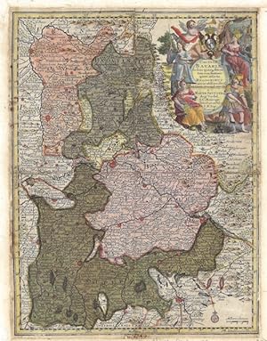
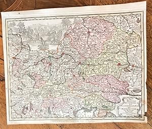
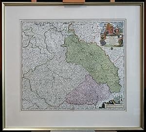
Circulus Bavariae
Published by Artist: Seutter Matthias ( - 1757 ) Augsburg; issued in: Augsburg; Seutter Matthias ( 1678 - 1757 ) Augsburg; Matthias Seutter (1678- 1757) Augsburg was the son of a goldsmith in Augsburg In 1697 Seutter began his studies in Nuremberg and subsequently worked in the publishing house of Jeremias Wolff in Augsburg In 1710 he established his own publishing house and print shop The Seutter publishing house produced a great number of maps atlases and globes However very few original maps were printed there as Augsburg at that time had no university and no connection to the fields of mathematics or the natural sciences Seutter therefore copied the work of other cartographers making his own engravings based on their models Over 500 maps were produc, 1678
Seller: Antique Sommer& Sapunaru KG, M�nchen, Germany
Seller Rating:

Technic: Copper print; colorit: original colored; condition: Mounted; size (in cm): 26 x 19,5 cm; Map shows Bavaria with a beautiful cartouche. History: The existence of a Bavarian tribal duchy has been documented since 555, which became part of the Frankish domain under the Merovingians. From 1180 to 1918 Bavaria was ruled by the Wittelsbachers as a territorial duchy. Bavaria experienced a period of numerous divisions into individual duchies from 1255 to 1503. Shortly before the first reunification, Ludwig IV. In 1328 became the first Wittelsbacher to become emperor, which meant a new high point in power for Bavaria. At the same time, however, the prince-archbishopric of Salzburg finally separated from the mother country Bavaria. In 1429, after the Straubing-Holland line became extinct, the Duchy of Bavaria-Straubing was divided between the Munich, Ingolstadt and Landshut lines. In 1447, Bavaria-Ingolstadt fell to Bavaria-Landshut, which in turn was won by Bavaria-Munich in the War of Succession in Landshut in 1503. The division of the country came to an end through the Primogenitur Act of Duke Albrecht IV of 1506. Bavaria took a leading position in the Counter-Reformation and emerged from the Thirty Years' War with territorial gains and the rise to the Electorate. In 1620, the troops of the Catholic League, under the leadership of the Bavarian general Tilly, defeated the Protestants in the Battle of the White Mountains near Prague. Then Tilly had the Palatinate occupied. As a thank you, Maximilian I received the electoral title in 1623 and the Upper Palatinate he occupied as war compensation in 1628. After the war, Elector Ferdinand Maria devoted himself to the reconstruction of the devastated country and pursued a cautious neutrality policy. During the War of the Spanish and Austrian Succession and in the course of Maximilian II. Emanuel's great power policy and later his son Karl Albrecht, Austria was twice temporarily occupied by absolutist Bavaria. In 1705 the Bavarian people rose against the imperial occupation. Only the battle of Aidenbach on January 8, 1706 ended with the complete defeat of the popular uprising. After Karl Albrecht's coronation, large parts of the electorate were occupied again until 1744. Karl Albrecht's son Maximilian III. Joseph finally ended the great power policy of his predecessors in 1745 and devoted himself to internal reforms. After the extinction of the old Bavarian line of the Wittelsbacher, the double electorate of Kurpfalz-Bavaria was created in 1777 under the reign of the Elector Karl Theodor from the Palatinate line of the Wittelsbacher. At the time of Napoleon, Bavaria was initially on the side of France and was able to record large territorial gains through secularization and mediatization. Salzburg, Tyrol, Vorarlberg and the Innviertel region, which was lost in 1779, fell temporarily to Bavaria. In the Peace of Pressburg, which was concluded on December 26, 1805 between France and the German Emperor Franz II, Bavaria, allied with Napoleon, was proclaimed a kingdom. King Max I. Joseph's Minister Maximilian Graf von Montgelas is considered the creator of the modern Bavarian state. In 1806 Napoleon Bonaparte elevated Bavaria to a kingdom. At the Vienna Congress in 1814, Bavaria was able to retain a large part of the area's profits as a victorious power, including what was now northern Bavaria, parts of Swabia and the Palatinate. In 1918 the Wittelsbach monarchy collapsed in the November Revolution. King Ludwig I, who had ruled since 1825, developed the Bavarian capital Munich into an art and university city. After the occupation by American troops, Bavaria became part of the newly founded Federal Republic in 1949.
-
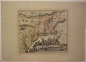
Recens edita totius Novi Belgii in America Septentrionali siti delineatio cura et sumtibus Matthaei Seutteri. Sac. Caes. Maj. Geographi August. Vind.
Published by Ediz. P.V., (o.J.).
Seller: Biblion Antiquariat, Z�rich, ZH, Switzerland
Association Member: GIAQ ILAB VEBUKU
Seller Rating:
21,5x25 cm. Kolorierte Karte. Unter Passepartout. Reprint der 4. Ausgabe von Seutters Karte, basierend auf Janssons Karte von 1651, Die "Restitutio View" mit einer neuen Ansicht von New York "Neu Jorck sive Neu Amsterdam" ersetzt und den zwei Textzeilen "Sac. Caes. .", Boston noch unkorrigiert mit Briston angegeben. Unten rechts "Ediz. P.V. - Die Karte ist verziert mit wilden Tieren und einer Szene mit Ureinwohnern, die dem Englischen K�nig George II Tribute entgegenbringen. - (Kleiner Einriss im rechten Rand ausserhalb der Platte).
-
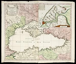
Nova Mappa Maris Nigri et Freti Constantinopolitani.
Published by Augsburg., 1741
Seller: EOS Buchantiquariat Benz, Z�rich, Switzerland
Association Member: ILAB VEBUKU
Seller Rating:
Art / Print / Poster
Altkolorierter Kupferstich. Blattgr�sse: 49.4 x 57.8 cm Zeigt das Schwarze Meer mit der Krim und Bosporus. Mit Ausschnitt vom Borporus mit Istanbul / Konstantinopel. Dekorative Karte von Matth�us Seutter, deutscher Verleger, Kartograph und Kupferstecher aus Augsburg. - Die in der Mitte gefaltete Karte mit Gebrauchsspuren und kleinen Einrissen an den R�ndern. + Wichtig: F�r unsere Kunden in der EU erfolgt der Versand alle 14 Tage verzollt ab Deutschland / Postbank-Konto in Deutschland vorhanden +.
-

XVII. Provinciae Belgii sive Germaniae inferioris prise. temporip Circ. Burgundico.
Published by Artist: Seutter Matthias ( - 1757 ) Augsburg; issued in: Augsburg; Seutter Matthias ( 1678 - 1757 ) Augsburg; Matthias Seutter (1678- 1757) Augsburg was the son of a goldsmith in Augsburg In 1697 Seutter began his studies in Nuremberg and subsequently worked in the publishing house of Jeremias Wolff in Augsburg In 1710 he established his own publishing house and print shop The Seutter publishing house produced a great number of maps atlases and globes However very few original maps were printed there as Augsburg at that time had no university and no connection to the fields of mathematics or the natural sciences Seutter therefore copied the work of other cartographers making his own engravings based on their models Over 500 maps were produc, 1678
Seller: Antique Sommer& Sapunaru KG, M�nchen, Germany
Seller Rating:
Technic: Copper print; colorit: original colored; condition: Very good; size (in cm): 20 x 25,5; Map shows total Benelus with two beautiful cartouches with coat of armsHistory: The area, which later includes the Benelux area, is called de Lage Landen in Dutch, Low Countries in English, consisting of Belgium, the Netherlands (Nederland) and Luxembourg. In the 19th century, three countries were united under the crown of the Dutch king from 1815 to 1830, until Belgium became independent. The forerunners of the Benelux Treaty were the economic union concluded between Luxembourg and Belgium on July 25, 1921.
-
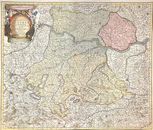
Stiria Ducatus juxta recentissimas observationes et accuratissimas mappas commoda.
Published by Augsburg [ca. 1740]., 1740
Kolor. Kupferkarte. 49 x 56 cm. (Plattengr.). Kupferkarte mit zwei fig�rl. kolorierten Kartuschen. Zeigt das gesamte Gebiet der Steiermark mit Teilen Westungarns und Kroatiens. Gewicht in Gramm: 1000.
-
Borussiae regnum cum adjacentisbus Regionibus mappa Geographica.
Published by Artist: Seutter Matthias ( - 1757 ) Augsburg; issued in: Augsburg; Seutter Matthias ( 1678 - 1757 ) Augsburg; Matthias Seutter (1678- 1757) Augsburg was the son of a goldsmith in Augsburg In 1697 Seutter began his studies in Nuremberg and subsequently worked in the publishing house of Jeremias Wolff in Augsburg In 1710 he established his own publishing house and print shop The Seutter publishing house produced a great number of maps atlases and globes However very few original maps were printed there as Augsburg at that time had no university and no connection to the fields of mathematics or the natural sciences Seutter therefore copied the work of other cartographers making his own engravings based on their models Over 500 maps were produc, 1678
Seller: Antique Sommer& Sapunaru KG, M�nchen, Germany
Seller Rating:
Technic: Copper print; colorit: original colored; condition: Very good; size (in cm): 19 x 25,5; Map shows total Prussia, ob inset map Neufchatel.
-
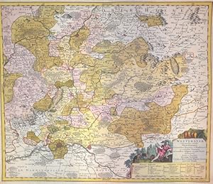
Wetteravia com omnibus inclusis Principatibus, Comitatibus, Dominiis et Praefecturis,
Published by Artist: Seutter Matthias ( - 1757 ) Augsburg; issued in: Augsburg; Seutter Matthias ( 1678 - 1757 ) Augsburg; Matthias Seutter (1678- 1757) Augsburg was the son of a goldsmith in Augsburg In 1697 Seutter began his studies in Nuremberg and subsequently worked in the publishing house of Jeremias Wolff in Augsburg In 1710 he established his own publishing house and print shop The Seutter publishing house produced a great number of maps atlases and globes However very few original maps were printed there as Augsburg at that time had no university and no connection to the fields of mathematics or the natural sciences Seutter therefore copied the work of other cartographers making his own engravings based on their models Over 500 maps were produc, 1678
Seller: Antique Sommer& Sapunaru KG, M�nchen, Germany
Seller Rating:
Technic: Copper print; colorit: original colored; condition: Perfect condition; size (in cm): 49 x 58; Map depicts Wetterai in Hassia with Frabkfurt, Friedberg and Gissen. History: In the 12th century, Hessen was passed to Thuringia. In the War of the Thuringian Succession (1247?1264), Hessen gained independence and became a Landgraviate within the Holy Roman Empire. It shortly rose to primary importance under Landgrave Philip the Magnanimous, who was one of the leaders of German Protestantism. After Philip's death in 1567, the territory was divided among his four sons from his first marriage into four lines: Hesse-Kassel (or Hesse-Cassel), Hesse-Darmstadt, Hessen-Rheinfels, and the also previously existing Hesse-Marburg. As the latter two lines died out quite soon (1583 and 1605), Hesse-Kassel and Hesse-Darmstadt were the two core states within the Hessian lands. Several collateral lines split off during the centuries, such as in 1622, when Hessen-Homburg split off from Hesse-Darmstadt. In the late 16th century, Kassel adopted Calvinism, while Darmstadt remained Lutheran and subsequently the two lines often found themselves on different sides of a conflict, most notably in the disputes over Hessen-Marburg and in the Thirty Years' War, when Darmstadt fought on the side of the Emperor, while Kassel sided with Sweden and France. War of Hessen: The Landgrave Frederick II (1720?1785) ruled as a benevolent despot, from 1760 to 1785. He combined Enlightenment ideas with Christian values, cameralist plans for central control of the economy, and a militaristic approach toward diplomacy.He funded the depleted treasury of the poor nation by loaning 19,000 soldiers in complete military formations to Great Britainto fight in North America during the American Revolutionary War, 1776?1783. These soldiers, commonly known as Hessians, fought under the British flag. The British used the Hessians in several conflicts, including in the Irish Rebellion of 1798. For further revenue, the soldiers were loaned to other places as well. Most were conscripted, with their pay going to the Landgrave.
-
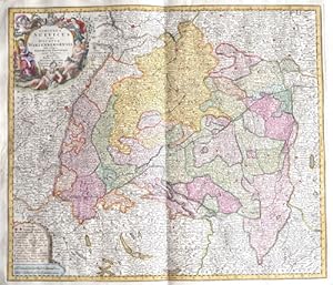
Circulus Suevicus in quo ducatus Wirtenbergensis
Published by Artist: Seutter Matthias ( - 1757 ) Augsburg; issued in: Augsburg; Seutter Matthias ( 1678 - 1757 ) Augsburg; Matthias Seutter (1678- 1757) Augsburg was the son of a goldsmith in Augsburg In 1697 Seutter began his studies in Nuremberg and subsequently worked in the publishing house of Jeremias Wolff in Augsburg In 1710 he established his own publishing house and print shop The Seutter publishing house produced a great number of maps atlases and globes However very few original maps were printed there as Augsburg at that time had no university and no connection to the fields of mathematics or the natural sciences Seutter therefore copied the work of other cartographers making his own engravings based on their models Over 500 maps were produc, 1678
Seller: Antique Sommer& Sapunaru KG, M�nchen, Germany
Seller Rating:
Technic: Copper print; colorit: original colored; condition: Very good; size (in cm): 50 x 58 cm; Splendid map showing the whole of Swabia with the towns of Augsburg, Ulm, Memmingen, Kempten, N�rdlingen, Lindau on Lake Constance, etc.; Baden-W�rttemberg with Constance, T�bingen, Stuttgart, Heidelberg, Pforzheim, Freiburg im Breisgau, etc. and two cartouches. History: Swabia also Suabia or Svebia, is a cultural, historic and linguistic region in southwestern Germany. The name is ultimately derived from the medieval Duchy of Swabia, one of the German stem duchies, representing the territory of Alemannia, whose inhabitants interchangeably were called Alemanni or Suebi. A new Swabian League (Schw�bischer Bund) was formed in 1488, opposing the expansionist Bavarian dukes from the House of Wittelsbach and the revolutionary threat from the south in the form of the Swiss. The territory of Swabia as understood today emerges in the early modern period. It corresponds to the Swabian Circle established in 1512. The Old Swiss Confederacy was de facto independent from Swabia from 1499 as a result of the Swabian War, while the Margraviate of Baden had been detached from Swabia since the twelfth century. Fearing the power of the greater princes, the cities and smaller secular rulers of Swabia joined to form the Swabian League in the fifteenth century. The League was quite successful, notably expelling the Duke of W�rttemberg in 1519 and putting in his place a Habsburg governor, but the league broke up a few years later over religious differences inspired by the Reformation, and the Duke of W�rttemberg was soon restored. The region was quite divided by the Reformation. While secular princes such as the Duke of W�rttemberg and the Margrave of Baden-Durlach, as well as most of the Free Cities, became Protestant, the ecclesiastical territories (including the bishoprics of Augsburg, Konstanz and the numerous Imperial abbeys) remained Catholic, as did the territories belonging to the Habsburgs (Further Austria), the Sigmaringen branch of the House of Hohenzollern, and the Margrave of Baden-Baden.
-
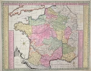
Les Routes exactes des Postes du Royaume de France.
Published by Artist: Seutter Matthias ( - 1757 ) Augsburg; issued in: Augsburg; Seutter Matthias ( 1678 - 1757 ) Augsburg; Matthias Seutter (1678- 1757) Augsburg was the son of a goldsmith in Augsburg In 1697 Seutter began his studies in Nuremberg and subsequently worked in the publishing house of Jeremias Wolff in Augsburg In 1710 he established his own publishing house and print shop The Seutter publishing house produced a great number of maps atlases and globes However very few original maps were printed there as Augsburg at that time had no university and no connection to the fields of mathematics or the natural sciences Seutter therefore copied the work of other cartographers making his own engravings based on their models Over 500 maps were produc, 1678
Seller: Antique Sommer& Sapunaru KG, M�nchen, Germany
Seller Rating:
Technic: Copper print; colorit: original colored; condition: Stain right corner; size (in cm): 45,5 x 58,5 cm; Map shows the whole of France with a coat of arms cartouche and a city index. History: It is estimated that today's France was settled about 48,000 years ago. Important rock paintings from the Paleolithic period have been preserved in the Lascaux cave From 600 BC Chr. Phoenician and Greek traders founded bases on the Mediterranean coast, while Celts settled from the northwest the country that was later called by the Romans as Gaul. The French Middle Ages were marked by the rise of kingship in the constant struggle against the independence of the nobility and the secular violence of the monasteries and religious orders. Starting from today's �le-de-France, the Capetinians enforced the idea of a unitary state, which was underpinned by participation in various crusades. The Normans invaded Normandy repeatedly, hence its name; in 1066 they conquered England. A long series of armed conflicts with England began under Louis VII after Ludwig's divorced wife Eleonore von Poitou and Aquitaine married Heinrich Plantagenet in 1152 and thus about half of France's territory fell to England. Philip II August, together with the Hohenstaufen family, largely displaced England from France until 1299; the English king Henry III Ludwig IX. recognize as suzerain. From 1226 France became an inheritance monarchy; in 1250 Ludwig IX was one of the most powerful rulers in the West. In the 17th and 18th centuries, France held European leadership and supremacy. The political and cultural charisma was significant: The court of Louis XIV became the model for absolutist states throughout Europe and the French Revolution with the declaration of human and civil rights, together with occupations by Napoleon Bonaparte, started in many countries the time and again Setbacks interrupted development towards democracy.
-
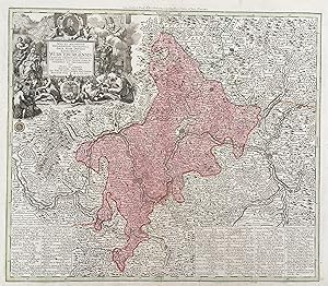
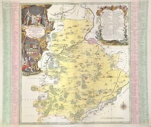
Archiducatus Austriae Inferioris
Published by Artist: Seutter Matthias ( - 1757 ) Augsburg; issued in: Augsburg; Seutter Matthias ( 1678 - 1757 ) Augsburg; Matthias Seutter (1678- 1757) Augsburg was the son of a goldsmith in Augsburg In 1697 Seutter began his studies in Nuremberg and subsequently worked in the publishing house of Jeremias Wolff in Augsburg In 1710 he established his own publishing house and print shop The Seutter publishing house produced a great number of maps atlases and globes However very few original maps were printed there as Augsburg at that time had no university and no connection to the fields of mathematics or the natural sciences Seutter therefore copied the work of other cartographers making his own engravings based on their models Over 500 maps were produc, 1678
Seller: Antique Sommer& Sapunaru KG, M�nchen, Germany
Seller Rating:
Technic: Copper print; colorit: original colored; condition: Perfect condition; size (in cm): 48,5 x 57,5 cm; Map shows the whole of Lower Austria with a magnificent cartouche and a coat of arms. History: The name Austria is first handed down in its Old High German form Ostarrichi from the year 996. The Latin form Austria was also used. In 1156 Austria became an independent duchy in the Holy Roman Empire. After the Babenbergs died out in 1246, the House of Habsburg prevailed in the struggle for rule in Austria. The area designated as Austria later included the entire Habsburg Monarchy and later the Austrian Empire, which was constituted in 1804, and the Austrian half of the Austro-Hungarian Dual Monarchy established in 1867. The present republic came into being in 1918.
-
Nova Mappa Archiducatus Austriae Superioris
Published by Artist: Seutter Matthias ( - 1757 ) Augsburg; issued in: Augsburg; Seutter Matthias ( 1678 - 1757 ) Augsburg; Matthias Seutter (1678- 1757) Augsburg was the son of a goldsmith in Augsburg In 1697 Seutter began his studies in Nuremberg and subsequently worked in the publishing house of Jeremias Wolff in Augsburg In 1710 he established his own publishing house and print shop The Seutter publishing house produced a great number of maps atlases and globes However very few original maps were printed there as Augsburg at that time had no university and no connection to the fields of mathematics or the natural sciences Seutter therefore copied the work of other cartographers making his own engravings based on their models Over 500 maps were produc, 1678
Seller: Antique Sommer& Sapunaru KG, M�nchen, Germany
Seller Rating:
Technic: Copper print; colorit: original colored; condition: Lower left and right corner perfectly replaced; size (in cm): 48,5 x 57,5 cm; Map shows the whole of Upper Austria with magnificent title cartouche. History: In the Middle Ages, a large part of Upper Austria belonged to the Duchy of Styria for a long time. King Ottokar P_emysl of Bohemia separated the Traungau, which belonged to Styria, from it in 1254 in the Peace of Ofen and in 1261 in the Peace of Vienna and shaped the land into the Principality ob der Enns. In 1264 the name supra anasum ('Ob(erhalb) der Enns') was first mentioned in a document, and Konrad von Summerau is referred to in a document as a provincial judge of the province of Upper Austria, although at that time the designation Austria superior ('Upper Austria') still applied to Tyrol and Vorder�sterreich. After 1490, the area gained a certain degree of independence in the Holy Roman Empire as the partial principality of Austria ob der Enns, and the estates held their own provincial assemblies in Linz. In the Habsburg division of 1564, Upper Austria, together with Lower Austria and the Bohemian lands, fell to the Roman-German Emperor Maximilian II. In 1779, in the Peace of Teschen, the Innviertel, previously part of the Duchy of Bavaria, became part of Upper Austria. During the Napoleonic Wars, Upper Austria was occupied several times by French troops. The provincial capital Linz also administered the province of Salzburg from 1816 to 1854.
-
Motiv: 55 x 48 cm; Blatt: 62,5 x 55 cm gedruckt auf dickerem Papier R�nder etwas knittrig, eine kleine hinterlegte Stelle im Mittelbug, schwacher Wasserfleck oben mittig, wurde zuerst gefaltet, dann gerollt gelagert. Insgesamt guter zeitgem��er Zustand Sprache: Deutsch 2001 gr.
-
-
-
Ad Ducat. Wurtenbergicum ad Terr. Ulm
Published by Artist: Seutter Matthias ( - 1757 ) Augsburg; issued in: Augsburg; Seutter Matthias ( 1678 - 1757 ) Augsburg; Matthias Seutter (1678- 1757) Augsburg was the son of a goldsmith in Augsburg In 1697 Seutter began his studies in Nuremberg and subsequently worked in the publishing house of Jeremias Wolff in Augsburg In 1710 he established his own publishing house and print shop The Seutter publishing house produced a great number of maps atlases and globes However very few original maps were printed there as Augsburg at that time had no university and no connection to the fields of mathematics or the natural sciences Seutter therefore copied the work of other cartographers making his own engravings based on their models Over 500 maps were produc, 1678
Seller: Antique Sommer& Sapunaru KG, M�nchen, Germany
Seller Rating:
Technic: Copper print; colorit: original colored; condition: Upper and lower margin perfectly replaced; size (in cm): 54 x 54; Map depicts the southern part of baden Wurtemberg with Hohentwies, Ueberliongen and the north part of the Lac de Constanz. Also ist shows the city of tlingen, Biberach, etc. and Ulm. History: Baden-Wuertemberg is a state in southwest Germany, east of the Rhine, which forms the border with France. It is is formed from the historical territories of Baden, Prussian Hohenzollern, and W�rttemberg, and also parts of Swabia. Baden W�rtemberg was only founded in 1952 by the merger of the states of W�rttemberg-Baden, Baden and W�rttemberg-Hohenzollern. Today the most populous city of Baden-W�rttemberg is the state capital Stuttgart, followed by Karlsruhe and Mannheim. Other major cities are Freiburg im Breisgau, Heidelberg, Ulm, Heilbronn, Pforzheim and Reutlingen. The early modern period was marked by the Reformation and the expansion efforts of the emerging states of Austria, Prussia, France and Sweden. Conflicts such as the Peasant War, the Thirty Years' War and the Palatinate War of Succession resulted from these. One of the focal points of the fighting, with corresponding consequences for the population and the economy, was in what is today Baden-W�rttemberg, which remained extremely fragmented territorially. At the beginning of the 19th century, around 300 states still had territorial rights in what is now Baden-W�rttemberg, but their number was reduced to four after the dissolution of the Old Empire. The Kingdom of W�rttemberg and the Grand Duchy of Baden were among the winners of the coalition wars. The two principalities of Hohenzollern-Sigmaringen and Hohenzollern-Hechingen survived mediatization due to their special relationship with Napol�on. In 1849, the Baden Revolution was put down by Prussian intervention forces, the Baden army was dissolved and rebuilt under Prussian leadership. In 1850 the two Hohenzollern states became the Prussian province of Hohenzollernsche Lande. With the new formation of the tribal duchies, the southern areas of what is now the state of Baden-W�rttemberg belonged to the Duchy of Swabia until the end of the High Middle Ages, the northern areas were located with the Duchy of Franconia.
-
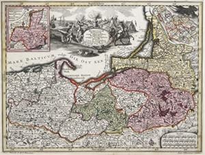
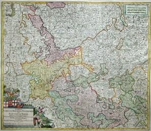
Archiepiscopatus et Electoratus Moguntinus
Published by Artist: Seutter Matthias ( - 1757 ) Augsburg; issued in: Augsburg; Seutter Matthias ( 1678 - 1757 ) Augsburg; Matthias Seutter (1678- 1757) Augsburg was the son of a goldsmith in Augsburg In 1697 Seutter began his studies in Nuremberg and subsequently worked in the publishing house of Jeremias Wolff in Augsburg In 1710 he established his own publishing house and print shop The Seutter publishing house produced a great number of maps atlases and globes However very few original maps were printed there as Augsburg at that time had no university and no connection to the fields of mathematics or the natural sciences Seutter therefore copied the work of other cartographers making his own engravings based on their models Over 500 maps were produc, 1678
Seller: Antique Sommer& Sapunaru KG, M�nchen, Germany
Seller Rating:
Technic: Copper print; colorit: original colored; condition: Right and left margin perfectly replaced, centerfold on lower part restored; size (in cm): 49 x 57cm; Map shows Hesse and its surrounding states with a splendid title cartouche and a mileage indicator cartouche. History: In the 12th century, Hessen was passed to Thuringia. In the War of the Thuringian Succession (1247?1264), Hessen gained independence and became a Landgraviate within the Holy Roman Empire. It shortly rose to primary importance under Landgrave Philip the Magnanimous, who was one of the leaders of German Protestantism. After Philip's death in 1567, the territory was divided among his four sons from his first marriage into four lines: Hesse-Kassel (or Hesse-Cassel), Hesse-Darmstadt, Hessen-Rheinfels, and the also previously existing Hesse-Marburg. As the latter two lines died out quite soon (1583 and 1605), Hesse-Kassel and Hesse-Darmstadt were the two core states within the Hessian lands. Several collateral lines split off during the centuries, such as in 1622, when Hessen-Homburg split off from Hesse-Darmstadt. In the late 16th century, Kassel adopted Calvinism, while Darmstadt remained Lutheran and subsequently the two lines often found themselves on different sides of a conflict, most notably in the disputes over Hessen-Marburg and in the Thirty Years' War, when Darmstadt fought on the side of the Emperor, while Kassel sided with Sweden and France. War of Hessen: The Landgrave Frederick II (1720?1785) ruled as a benevolent despot, from 1760 to 1785. He combined Enlightenment ideas with Christian values, cameralist plans for central control of the economy, and a militaristic approach toward diplomacy.He funded the depleted treasury of the poor nation by loaning 19,000 soldiers in complete military formations to Great Britainto fight in North America during the American Revolutionary War, 1776?1783. These soldiers, commonly known as Hessians, fought under the British flag. The British used the Hessians in several conflicts, including in the Irish Rebellion of 1798. For further revenue, the soldiers were loaned to other places as well. Most were conscripted, with their pay going to the Landgrave.
-
Praefecturae Leucopetranae.
Published by Artist: Seutter Matthias ( - 1757 ) Augsburg; issued in: Augsburg; Seutter Matthias ( 1678 - 1757 ) Augsburg; Matthias Seutter (1678- 1757) Augsburg was the son of a goldsmith in Augsburg In 1697 Seutter began his studies in Nuremberg and subsequently worked in the publishing house of Jeremias Wolff in Augsburg In 1710 he established his own publishing house and print shop The Seutter publishing house produced a great number of maps atlases and globes However very few original maps were printed there as Augsburg at that time had no university and no connection to the fields of mathematics or the natural sciences Seutter therefore copied the work of other cartographers making his own engravings based on their models Over 500 maps were produc, 1678
Seller: Antique Sommer& Sapunaru KG, M�nchen, Germany
Seller Rating:
Technic: Copper print; colorit: original colored; condition: Perfect condition; size (in cm): 48,5 x 58,5; Map depicts the Burgenland area in Sachsen Anhalt with the city of Weissenfels, Teuchern, Zeitz, elsdorf, Schk�len (Saale-Holzlandkreis, Th�ringen)? two decorative carouches with coat of arms on the right and left side.
-
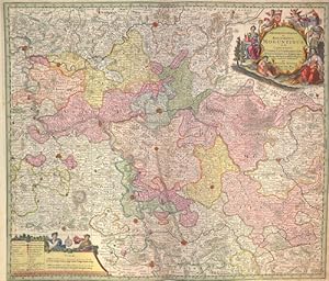
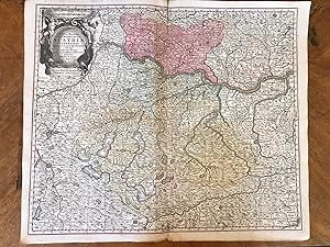
Synopsis Circuli Rhenani Inferioris Cive Electorum Rheni, exhibens Archi-Episcopatum Morguntinum Coloniensem, Trevirensem et Palatinatum Rheni .
Published by Artist: Seutter Matthias ( - 1757 ) Augsburg; issued in: Augsburg; Seutter Matthias ( 1678 - 1757 ) Augsburg; Matthias Seutter (1678- 1757) Augsburg was the son of a goldsmith in Augsburg In 1697 Seutter began his studies in Nuremberg and subsequently worked in the publishing house of Jeremias Wolff in Augsburg In 1710 he established his own publishing house and print shop The Seutter publishing house produced a great number of maps atlases and globes However very few original maps were printed there as Augsburg at that time had no university and no connection to the fields of mathematics or the natural sciences Seutter therefore copied the work of other cartographers making his own engravings based on their models Over 500 maps were produc, 1678
Seller: Antique Sommer& Sapunaru KG, M�nchen, Germany
Seller Rating:
Technic: Copper print; colorit: original colored; condition: Some folds perfectly set down,upper and lower margin replaced; size (in cm): 49 x 57; Map shows the River Rhine with D�sseldorf, Cologne. Bonn, Mainz, Worms, Mannheim, SpeyerHistory: The headwaters of the Rhine lie predominantly in the Swiss canton of Graub�nden; its estuary arms reach the North Sea in the Netherlands, where it is the most water-rich tributary. The Rhine bears its name without distinguishing additions only from the confluence of the Vorderrhein and Hinterrhein at Tamins-Reichenau. Traditionally, Lake Toma near the Oberalp Pass near Sedrun in the Gotthard region is considered the source of the Vorderrhein and the Rhine as a whole. The Hinterrhein rises in the high valley Rheinwald below the Rheinwaldhorn. At Tamins-Reichenau the Vorderrhein and Hinterrhein join to form the Alpenrhein.Hochrhein: The Hochrhein begins at Stein am Rhein at the western end of the Untersee. In contrast to the Alpine Rhine and the Upper Rhine, it flows mainly to the west, dropping from 395 m to 252 m. The Rhine is the first major river in the world. In the center of Basel, the first large city on the course of the stream, lies the "Rhine bend"; here the High Rhine ends. Upper Rhine: At Mainz, the Rhine leaves the Upper Rhine Graben and flows through the Mainz Basin. The section of the Upper Rhine from Mainz down through the Rheingau and Rheinhessen is also known as the Inselrhein. The Upper Rhine Valley was already an important cultural landscape in Europe in ancient times and the Middle Ages. Today, the Upper Rhine is the location of numerous important industrial and service companies with the centers in Basel, Strasbourg and Mannheim-Ludwigshafen. Middle Rhine: The Mainz Basin ends at Bingen. The largest tributaries of the Middle Rhine are the Lahn and Moselle, which flow in from the right and left at Koblenz. Almost the entire length of the Middle Rhine runs through the state of Rhineland-Palatinate. The valley area between R�desheim and Koblenz is part of the UNESCO World Heritage Upper Middle Rhine Valley. At Sankt Goarshausen, the Rhine encloses the famous Loreley Rock with a sharp river bend, where it reaches a depth of 25 meters. With its high-ranking architectural monuments, vine-covered slopes, towns crowded together on narrow banks and hilltop castles strung on rocky outcrops, the Middle Rhine Valley is considered the epitome of Rhine Romanticism. Lower Rhine: Near Bonn, north of the Siebengebirge, the Rhine changes from the low mountain region to the North German lowlands and becomes the Lower Rhine at the mouth of the Sieg. The Lower Rhine lies entirely in North Rhine-Westphalia. Its banks are mostly heavily populated and industrialized, especially in the agglomerations of Cologne, D�sseldorf and the Ruhr area. Delta Rhine: At the Dutch-German state border, the Rhine-Meuse delta, the most important natural unit of the Netherlands, begins with the Rhine division, and thus the Delta Rhine.
-
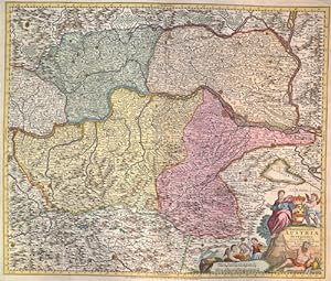
ca. 60 x 52 cm ca.1744, kolorierte Kupferstich-Karte, 60x 52 cm, in der Mitte gefaltet, Bug verst�rkt, Ecken/Kanten etwas bestossem, leicht randl�diert, vergilbt, etwas fleckig und wellig, sch�ne Koloration, f�r das Alter mittel bis gut Sprache: Deutsch Das Muhlviertel, das Haussviertel, Das Schwartzviertel, Das Traunviertel, Teile von Oberbayern, Stift Passau, Unter�sterreich, Steyer Marck, Erzstift Salzburg, miminal auch K�nigreich B�hmen.
-
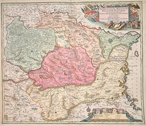
Transylvaniae, Moldaviae, Walachiae, Bulgariae.
Published by Artist: Seutter Matthias ( - 1757 ) Augsburg; issued in: Augsburg; Seutter Matthias ( 1678 - 1757 ) Augsburg; Matthias Seutter (1678- 1757) Augsburg was the son of a goldsmith in Augsburg In 1697 Seutter began his studies in Nuremberg and subsequently worked in the publishing house of Jeremias Wolff in Augsburg In 1710 he established his own publishing house and print shop The Seutter publishing house produced a great number of maps atlases and globes However very few original maps were printed there as Augsburg at that time had no university and no connection to the fields of mathematics or the natural sciences Seutter therefore copied the work of other cartographers making his own engravings based on their models Over 500 maps were produc, 1678
Seller: Antique Sommer& Sapunaru KG, M�nchen, Germany
Seller Rating:
Technic: Copper print; colorit: colored; condition: Margins mounted; size (in cm): 49 x 58; Map shows Transilvanien, Moldavien, Walachia and Bulgarien.
-
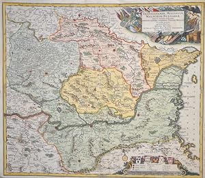
Transylvaniae, Moldaviae, Walachiae, Bulgariae.
Published by Artist: Seutter Matthias ( - 1757 ) Augsburg; issued in: Augsburg; Seutter Matthias ( 1678 - 1757 ) Augsburg; Matthias Seutter (1678- 1757) Augsburg was the son of a goldsmith in Augsburg In 1697 Seutter began his studies in Nuremberg and subsequently worked in the publishing house of Jeremias Wolff in Augsburg In 1710 he established his own publishing house and print shop The Seutter publishing house produced a great number of maps atlases and globes However very few original maps were printed there as Augsburg at that time had no university and no connection to the fields of mathematics or the natural sciences Seutter therefore copied the work of other cartographers making his own engravings based on their models Over 500 maps were produc, 1678
Seller: Antique Sommer& Sapunaru KG, M�nchen, Germany
Seller Rating:
Technic: Copper print; colorit: original colored; condition: Upper margin missing part perfectly restored and retouched; size (in cm): 49,5 x 57; Map shows Transilvanien, Moldavien, Walachia and Bulgaria. With two decorative cartouches and detailed representation of rivers, forests and cities. History: In the historical sense, Eastern Europe refers to Ukraine, the European part of Russia, Belarus and the Republic of Moldova. Occasionally, the Caucasian countries of Georgia, Armenia and, conditionally, Azerbaijan are also seen as part of Eastern Europe. By Christian Giordano and other scholars, one of the six historical regions of Europe is called "Eastern Europe." The Eastern European countries are historically and culturally largely influenced by the Orthodox Church (Islamic Azerbaijan excepted) and were - in contrast to the Ottoman-dominated Balkans - under the rule of the Russian Empire. Like the Balkan countries, the countries of Eastern Europe were for a long time backward agricultural states (cf.: Intermediate Europe) and had no or only a limited share in the social developments of the Renaissance, Reformation and Enlightenment of the Western world.