Order Total (1 Item Items):
Shipping Destination:

Nicholas Sanson (47 results)
Skip to main search results
Product Type
- All Product Types
- Books (30)
- Magazines & Periodicals
- Comics
- Sheet Music
- Art, Prints & Posters (1)
- Photographs
- Maps (15)
-
Manuscripts &
Paper Collectibles (1)
Condition
- All Conditions
- New
- Used
Binding
- All Bindings
- Hardcover (8)
- Softcover
Collectible Attributes
- First Edition (3)
- Signed
- Dust Jacket (1)
- Seller-Supplied Images (25)
- Not Printed On Demand
Free Shipping
Seller Location
Seller Rating
-
Map of Afrique ou Librie Ulterieure ou sont La Saara ou Desert, Le Pays des Negres La Guinee &c.
Published by Paris: Nicholas Sanson., 1656
Art / Print / Poster
Condition: Good. Hand colored engraving. 18.5 x 29.7 cm. (plate). Very Good, folded in center.
-

No Binding. Condition: Very Good. No Jacket. Attractive hand coloured map of Anatolia (Turkey), by Nicholas Sanson, from 1692. From Introductio ad Geographiam novam et veterem. Regionis Tabulae, item Chartae LXV Sansonis. Ex Officina Francisci Halma, Utrecht, 1692. Page size 23.5 x 18 cm approx, single fold Tape to the corners, tape reside to the right hand edge, otherwise only light wear and marks, colours bright. Good margins. Very Good overall. Free standard airmail worldwide. This does not include tracking, which is available at additional cost.
-
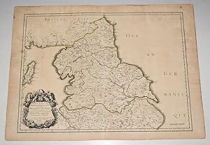
'Ancien Royaume de Northumberland, aujourdhuy Provinces de Nort. Engraved map of northern England, focusing on Northumberland.
Published by PARIS Chez l?Auteur 1654., 1654
Seller: PROCTOR / THE ANTIQUE MAP & BOOKSHOP, DORCHESTER, United Kingdom
Association Member: PBFA
Seller Rating:

Map
Title cartouche to lower left corner. Blank on verso. In good condition. Some light tanning on edges, with a few faint foxing marks. A few hole top of centre fold on map. Small neatly repair tear lower margin, and small hole top margin. With original outline hand colouring. Engraved Size 17.5 x 23 inches Nicolas Sanson (1600-1667) sometimes called Nicolas Sanson d'Abbeville or Sanson d'Abbeville, was the most important French cartographer of the 17th century. Tooley called Sanson "the founder of the French school of cartography." He began making maps in the late 1620s, and in the 1630s he was working with Melchior Tavernier. Later, Sanson worked in concert with the print publisher Pierre Mariette, with whom he published his great atlas: Cartes g�n�rales de toutes les parties du monde (1658). After Sanson's death in 1667, his son Guillaume carried on the business in partnership with Alexis Hubert Jaillot. Guillaume established himself as a very important French mapmaker in his own right.
-
Original Engraved Map Anciens Royaumes De Kent, D'Essex, et De Sussex ou sont Aujourdhuy les Comt�s Kent, D'Essex, Middlessex, Et Hartford De Sussex, Et Surrey. Avecq le Pas De Calais, et Partie des Costes du Pays Bas, de Picardie, et Normandie. Sanson's Double page map of the south east England shown with the adjacent coastline of France and Belgium.
Published by PARIS Chez l?Auteur 1654., 1654
Seller: PROCTOR / THE ANTIQUE MAP & BOOKSHOP, DORCHESTER, United Kingdom
Association Member: PBFA
Seller Rating:
Map
Title cartouche to lower right corner. Blank on verso. In good condition. Some light tanning on edges, with a few faint foxing marks. A few small nicks lower margin edge. With original outline hand colouring. Engraved Size 17.5 x 23 inches Nicolas Sanson (1600-1667) sometimes called Nicolas Sanson d'Abbeville or Sanson d'Abbeville, was the most important French cartographer of the 17th century. Tooley called Sanson "the founder of the French school of cartography." He began making maps in the late 1620s, and in the 1630s he was working with Melchior Tavernier. Later, Sanson worked in concert with the print publisher Pierre Mariette, with whom he published his great atlas: Cartes g�n�rales de toutes les parties du monde (1658). After Sanson's death in 1667, his son Guillaume carried on the business in partnership with Alexis Hubert Jaillot. Guillaume established himself as a very important French mapmaker in his own right.
-
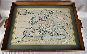
Europa vetus ex Connatibus Geographicis Nicolai Sanson
Published by Amsterdam: Johannes Covens and Cornelis Mortier, [ca. 1740], 1740
2 sheets joined (sheet size 21 x 24 7/8 inches; 15 3/8 x 23 3.5/8 inches to the neat line) full margins showing the plate mark. A fine engraved detailed map of Europe, the title within an elaborate and elegant cartouche upper left; original hand color in part (a little toned at the edges) An exceptional map of Europe by Covens and Mortier in a splendid condition. This map was originally made by Nicholas Sanson d Abbeville (1600-1667), the founder of the French School of Geography, a school that was unprecedented in its attention to precision and scientific detail and discarded much of the decorative embellishments of previous maps as irrelevant. Johannes Covens (1697-1774) and Cornelis Mortier (1699-1783) were the founders of the biggest cartographic publishing company of the eighteenth century.
-
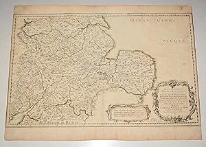
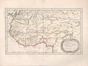
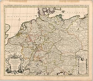
La Germanie en quatre grands peuples [This title has been overlaid onto the original title of the map: "Germania Antiqua"]
Publication Date: 1651
Map
Condition: Good. 'La Germanie en quatre grands peuples' by Nicholas SANSON 1651 old antique map. Antique copperplate map with original outline colouring; "Par N. Sanson Geog. Ord du Roy. A Paris chez M. Tavernier Graveur & imprimeur du Roy pour les Cartes Geographiques & autres tailles doulces. Et a present chez Mariette, rue St Jacques � l'Esperance avec privilege du Roy". Nicolas Sanson (1600 1667) was a French cartographer, sometimes called the 'father of French cartography'. (1651). 41.5 x 55.5cm, 16.25 x 22 inches; this is a folding map. Condition: Good. There is nothing printed on the reverse side, which is plain. The map depicts Greater Germany - The Holy Roman Empire - in the middle of the seventeenth century. The map covers central Europe, including present day Netherlands, Germany, Slovenia, Austria, Switzerland, the Czech Republic and northern Italy to the Adriatic Sea and much of Belgium, Hungary, Poland, Slovakia and Croatia.
-
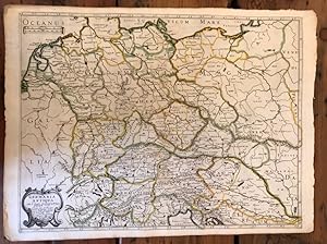
L'Allemagne par ses Estats, Principaut�s &. [This title has been overlaid onto the original title of the map: "Carte Generale de l'Empire d'Allemagne et Pays Circonvoisins."]
Publication Date: 1645
Map
Condition: Good. 'L'Allemagne par ses Estats, Principaut�s &.' by Nicholas SANSON 1645 old map. Antique copperplate map with original outline colouring; "Par N. Sanson Geog. Ord du Roy. A Paris par M. Tavernier Idrographe et Graveur ordinaire du Roy pour les Cartes Geographiques. Et a present chez Mariette, rue St Jacques � l'Esperance avec privilege du Roy pour 20 ans 1645". Nicolas Sanson (1600 1667) was a French cartographer, sometimes called the 'father of French cartography'. (1645). 41.5 x 57.0cm, 16.25 x 22.5 inches; this is a folding map. Condition: Good. There is nothing printed on the reverse side, which is plain. The map depicts Greater Germany - The Holy Roman Empire - in the middle of the seventeenth century. The map covers central Europe, including present day Netherlands, Germany, Slovenia, Austria, Switzerland, the Czech Republic and northern Italy to the Adriatic Sea and much of Belgium, Hungary, Poland, Slovakia and Croatia.
-
L'Allemagne par cercles [This title has been overlaid onto the original title of the map: "Carte Generale de l'Empire d'Allemagne et Pays Circonvoisins."]
Publication Date: 1645
Map
Condition: Good. 'L'Allemagne par cercles' by Nicholas SANSON. Central Europe 1645 old map. Antique copperplate map with original outline colouring; "Par N. Sanson Geog. Ord du Roy. A Paris par M. Tavernier Idrographe et Graveur ordinaire du Roy pour les Cartes Geographiques. Et a present chez Mariette, rue St Jacques � l'Esperance avec privilege du Roy pour 20 ans 1645". Nicolas Sanson (1600 1667) was a French cartographer, sometimes called the 'father of French cartography'. (1645). 41.5 x 57.0cm, 16.25 x 22.5 inches; this is a folding map. Condition: Good. There is nothing printed on the reverse side, which is plain. The map depicts Greater Germany - The Holy Roman Empire - in the middle of the seventeenth century. The map covers central Europe, including present day Netherlands, Germany, Slovenia, Austria, Switzerland, the Czech Republic and northern Italy to the Adriatic Sea and much of Belgium, Hungary, Poland, Slovakia and Croatia.
-
La Germanie en moyens peuples [This title has been overlaid onto the original title of the map: "Germania Antiqua"]
Publication Date: 1651
Map
Condition: Good. 'La Germanie en moyens peuples' by Nicholas SANSON. Central Europe 1651 map. Antique copperplate map with original outline colouring; "Par N. Sanson Geog. Ord du Roy. A Paris chez M. Tavernier Graveur & imprimeur du Roy pour les Cartes Geographiques & autres tailles doulces. Et a present chez Mariette, rue St Jacques � l'Esperance avec privilege du Roy". Nicolas Sanson (1600 1667) was a French cartographer, sometimes called the 'father of French cartography'. (1651). 41.5 x 55.5cm, 16.25 x 21.75 inches; this is a folding map. Condition: Good. There is nothing printed on the reverse side, which is plain. The map depicts Greater Germany - The Holy Roman Empire - in the middle of the seventeenth century. The map covers central Europe, including present day Netherlands, Germany, Slovenia, Austria, Switzerland, the Czech Republic and northern Italy to the Adriatic Sea and much of Belgium, Hungary, Poland, Slovakia and Croatia.
-
L'Allemagne en General divis�e en trois principales parties [This title has been overlaid onto the original title of the map: "Carte Generale de l'Empire d'Allemagne et Pays Circonvoisins."]
Publication Date: 1645
Map
Condition: Good. 'L'Allemagne en General divis�e en trois principales parties'. N SANSON 1645 map. Antique copperplate map with original outline colouring; "Par N. Sanson Geog. Ord du Roy. A Paris par M. Tavernier Idrographe et Graveur ordinaire du Roy pour les Cartes Geographiques. Et a present chez Mariette, rue St Jacques � l'Esperance avec privilege du Roy pour 20 ans 1645". Nicolas Sanson (1600 1667) was a French cartographer, sometimes called the 'father of French cartography'. (1645). 42.0 x 56.5cm, 16.5 x 22.25 inches; this is a folding map. Condition: Good. There is nothing printed on the reverse side, which is plain. The map depicts Greater Germany - The Holy Roman Empire - in the middle of the seventeenth century. The map covers central Europe, including present day Netherlands, Germany, Slovenia, Austria, Switzerland, the Czech Republic and northern Italy to the Adriatic Sea and much of Belgium, Hungary, Poland, Slovakia and Croatia.
-
L'Allemagne par archeves. Ch�s et Evesch�s [This title has been overlaid onto the original title of the map: "Carte Generale de l'Empire d'Allemagne et Pays Circonvoisins."]
Publication Date: 1645
Map
Condition: Good. 'L'Allemagne par archeves. Ch�s et Evesch�s' by Nicholas SANSON 1645 old map. Antique copperplate map with original outline colouring; "Par N. Sanson Geog. Ord du Roy. A Paris par M. Tavernier Idrographe et Graveur ordinaire du Roy pour les Cartes Geographiques. Et a present chez Mariette, rue St Jacques � l'Esperance avec privilege du Roy pour 20 ans 1645". Nicolas Sanson (1600 1667) was a French cartographer, sometimes called the 'father of French cartography'. (1645). 41.5 x 57.0cm, 16.5 x 22.5 inches; this is a folding map. Condition: Good. There is nothing printed on the reverse side, which is plain. The map depicts Greater Germany - The Holy Roman Empire - in the middle of the seventeenth century. The map covers central Europe, including present day Netherlands, Germany, Slovenia, Austria, Switzerland, the Czech Republic and northern Italy to the Adriatic Sea and much of Belgium, Hungary, Poland, Slovakia and Croatia.
-
Anciens Royaumes de Mercie et East Angles, ou sont les Comtes, ou Shiries de Chester, Darby, Nottingham, Lincolne, Rutland, Leicester, Stafford, Shrop-Sh, Hereford, Worcester, Warwick, Northampton, Huntington, Bedford, Buskingham, Oxford et Glocester en Mercie, Cambridge, Norfolk et Suffolk en East Angles". Decorative map of central England from Norwich (in the East) to Cardiff (in the West).
Published by PARIS Chez l?Auteur 1654., 1654
Seller: PROCTOR / THE ANTIQUE MAP & BOOKSHOP, DORCHESTER, United Kingdom
Association Member: PBFA
Seller Rating:
Title cartouche to lower right corner. Blank on verso. In good condition. Some light tanning on edges, with a few faint foxing marks. With original outline hand colouring. Engraved Size 17.5 x 23 inches Nicolas Sanson (1600-1667) sometimes called Nicolas Sanson d'Abbeville or Sanson d'Abbeville, was the most important French cartographer of the 17th century. Tooley called Sanson "the founder of the French school of cartography." He began making maps in the late 1620s, and in the 1630s he was working with Melchior Tavernier. Later, Sanson worked in concert with the print publisher Pierre Mariette, with whom he published his great atlas: Cartes g�n�rales de toutes les parties du monde (1658). After Sanson's death in 1667, his son Guillaume carried on the business in partnership with Alexis Hubert Jaillot. Guillaume established himself as a very important French mapmaker in his own right.
-
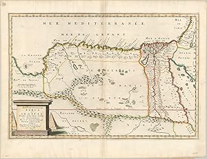
Royaume et Desert de Barca et L'Egypte Attractive mid-17th century map of Egypt issued by the 'founder of French cartography.'
Publication Date: 1655
Seller: Curtis Wright Maps, Berwyn, IL, U.S.A.
Seller Rating:

Condition: Fine. This lovely copperplate engraved map of Ottoman Egypt was published in Paris by Nicholas Sanson in 1655. The Nile and its expansive delta is depicted in some detail, with cities and towns of various sizes dotting either bank. Hills and scattered forests are depicted pictorially, with the Atlas mountains prominently featured in the west. Portions of Arabia, the Red Sea, and the Holy Land are also included within the image. A decorative cartouche in the lower right includes the date, cartographer, and title within an architectural base (plinth) and includes two pyramids in the background. These iconic Egyptian landmarks are also noted with small symbols on the map, near Giza. Sheet Width (in) 22 Sheet Height (in) 16.8 Condition Description Minor discoloration and wear along centerfold and issue on somewhat thin paper. Otherwise in excellent condition, with attractive hand color.
-
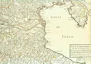
Basse Lombardie o� sont les Estats de Venise en Italie Mantove Parme Mod�ne Trente (17th Century Map).
Published by [Paris]: 17th Century European Publisher, [1648]., 1648
Manuscript / Paper Collectible
Condition: Good. 22 x 16 inches. Very Good. 17th Century hand colored map of Lower Lombardy. Some toning, and two one-inch tears at bottom edge. Text in French. Scarce.Nicholas Sanson (1600-1667) is considered the father of French cartography in its golden age from the mid-seventeenth century to the mid-eighteenth. Over the course of his career he produced over 300 maps. His success can be chalked up to his geographic and research skills, but also to his partnership with Pierre Mariette. Previously, Sanson had worked primarily with the publisher Melchior Tavernier. Mariette purchased Tavernier's business in 1644. Sanson worked with Mariette until 1657, when the latter died. Mariette's son, also Pierre, helped to publish the Cartes g�n�rales de toutes les parties du monde.
-
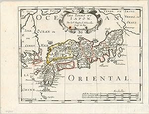
Les Isles du Japon The first edition of a pirated map of Japan.
Publication Date: 1683
Seller: Curtis Wright Maps, Berwyn, IL, U.S.A.
Seller Rating:
Condition: Fine. "This interesting map of Japan was originally issued in 1652 by Nicholas Sanson, Royal Geographer to the King of France. This is a later example engraved by Antoine de Winter and published in Utrecht by Francois Halma in 1683 as part of a pirated edition of L'Europe en plusieurs cartes. According to Daniel Crouch; "Francois Halma (1653-1722) set up his printing business in Utrecht in 1674, where he issued a number of pirated maps and atlases. In this instance, since Sanson was dead, Halma may have felt that there no harm and much profit to be gained from re-printing his work. The engraver, Antoine de Winter (c1652-1700) achieved some notoriety for plagiarizing Petter Gedda's charts of the Baltic Sea, selling them on to Loots and Doncker, for inclusion in their atlases, who were subsequently sued, and ordered to surrender the plates and pay a fine of 300 florins." The image is based on Dutch and Jesuit sources and shows the island chain oriented east-west between the 'Isle de Corey' (Korea) and the 'Terre de Iesso' (Hokkaido). Numerous smaller surrounding islands are also labeled and topography is depicted pictorially. A fascinating depiction of the archipelago that also reflects the economic realities of contemporary cartographic production that continue to this day." Sheet Width (in) 11 Sheet Height (in) 8.7 Condition Description Creased along originally issued fold lines and one small spot visible in the title cartouche. One small tear, confined to the margin in the lower right, has been repaired on the verso with archival tape.
-
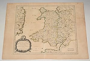
Principaut� de Galles: ou sont les Comt�s, ou Shiries de Anglesey I. Carnarvan, Denbigh, Flint, Merioneth, et Montgomery en Nort-Walles. MAP of WALES
Published by PARIS Chez l?Auteur 1658, 1658
Seller: PROCTOR / THE ANTIQUE MAP & BOOKSHOP, DORCHESTER, United Kingdom
Association Member: PBFA
Seller Rating:
Title cartouche to lower left corner. Blank on verso. In good condition. Some light tanning on edges, with a few faint foxing marks. With original outline hand colouring. Engraved Size 17.5 x 23 inches Nicolas Sanson (1600-1667) sometimes called Nicolas Sanson d'Abbeville or Sanson d'Abbeville, was the most important French cartographer of the 17th century. Tooley called Sanson "the founder of the French school of cartography." He began making maps in the late 1620s, and in the 1630s he was working with Melchior Tavernier. Later, Sanson worked in concert with the print publisher Pierre Mariette, with whom he published his great atlas: Cartes g�n�rales de toutes les parties du monde (1658). After Sanson's death in 1667, his son Guillaume carried on the business in partnership with Alexis Hubert Jaillot. Guillaume established himself as a very important French mapmaker in his own right.
-
L'Europe divisee suivant l'etendue de ses principaux Etats, subdivises en leurs principales Provinces
Published by Paris: 1738, 1738
2 sheets joined (sheet size 21 6/8 x 30 inches; 18 x 27 7/8 inches to the neat line), full margins showing the plate mark. A fine engraved detailed map of Europe, the title within a nicely ornamented Louis-XV-style cartouche upper right, scale within a small sober cartouche, the left part of the map is a kind of manual which gives some information on the scientific information the map provides in political geography, natural geography and astronomic geography; with original hand color in outline (spot on the upper middle margin, vertical fold marks, a little toned at the edges). A fine and very interesting political, natural and astronomical map of Europe. Gilles Robert de Vaugondy (1688-1766), also known as Le Sieur or Monsieur Robert, and his son, Didier Robert de Vaugondy (c.1723-1786), were leading mapmakers in France during the 18th century. In 1757, they published The 'Atlas Universel' in which they integrated older sources with more modern maps. This dialogue between old and new is also suitable for this map, as it is originally made by Nicholas Sanson (1600-1667), who was the founder of the French school of cartography.
-
L'Allemagne An uncommon map covering much of the Holy Roman Empire during the early 18th century.
Published by c. 1730, 1730
Seller: Curtis Wright Maps, Berwyn, IL, U.S.A.
Seller Rating:
Condition: Fine. "Though described in the title cartouche as L'Allemagne, French for Germany, this map long predates the modern German state as we know it today. A second dedicatory title, translated here from its original Latin, provides further context - "A new description of the German Empire and divided into all its electoral circles for the use of the most serene Duke of Burgundy". At the time of publication, Germany was fractured between numerous smaller states, kingdoms, and duchies that comprised the larger Holy Roman Empire. Other entities included within the image are the Kingdoms of Poland, France, and Prussia, the Dutch United Provinces, the Swiss Confederation, and the Republic of Venice. Outline color attempts to make sense of the complicated territorial situation, with numerous enclaves, contested borders, and independent cities all adding to the confusion. The myriad of interests is reflected in the numerous distance scales in the lower right, which also contains a key identifying the symbols for an Archdiocese, Bishopric, Chateau, and University. A second cartouche in the opposite corner is surrounded by decorative embellishments, allegorical figures, weapons of war, and garland held aloft by the Imperial Eagle. The map was published with imperial privilege in Amsterdam by Johannes Covens and Pierre Mortier and dedicated to Louis, Duke of Burgundy. The image is based on earlier cartography by Guillaume D'Lisle and Nicholas Sanson using sources such as Tycho-Brah�, Kepler, Snellius, and other members of the Royal Academy of Sciences (according to the cartouche). Source." Sheet Width (in) 25.25 Sheet Height (in) 22 Condition Description Scattered light spotting in the lower right that just enters the neat line and two stains in the top margin from linen tape applied to the verso for framing purposes. Otherwise in very good condition, with attractive outline color and a bold impression on thick, woven paper.
-
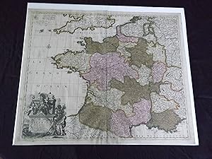
Le Royaume De France divise en Toutes fes Provinces� �
Published by c1700., Amsterdam:, 1700
Seller: Nicholas D. Riccio Rare Books, ABAA, Florham Park, NJ, U.S.A.
Seller Rating:
Copper engraved map, double page, (24" x 20"), hand colored, and large uncolored title cartouches. Some minor soiling, a little wear along centerfold, with old verso repair, normal aging; very good. Samson (1600-1667) is often referred to as the father of French cartography. Louis XIII was impressed with his work and appointed him "Geographe Ordinaire du Roi". During his career Sanson would produce about 300 maps, and his major atlas "Cartes Generales de Toutes les Parties du Monde" would represent an important part of his body of work. While two of his sons continued publication of his maps after his death, Pieter Schenk (1655-1718), an important publisher and engraver in his own right, published this map. The map is attractively colored and gives a detailed view of the provinces of France. The map is also decorated with a large title cartouche. Bagrow p. 185. map hist website.
-
Europa Vetus ex Conatih. Geographicis N. Sanson Abbavillaei. Christianiss. Galhiar. Regis Geographi (Original, Colored Map, Framed Under Glass)
Published by Petrum Mariette: Lutetiae Parisiorum, 1650
Map First Edition
Maps. Condition: Very Good. First Edition. [Ancient Europe : The Roman Empire] Fine hand-colored, double-page engraved map of Roman provinces of Europe. Mounted in wood frame, with wooden side handles. Dimensions of mounted image: 40 x 56 cm. (53 x 69.5 cm in frame). Latin province names, cities, seas. This is an oversized or heavy book, which requires additional postage for international delivery outside the US.
-
Iudaea seu Terra Sancta qu� Hebraraeorum sive Israelitarum in suas duodecim Tribus divisa Regnis Iuda et Israel. Gulielmi Sanson.Hubertus Iallot.
Amsterdam, Huguetan & Mortier, 1691. 56x85 cm. Large engraved map of Terra Sancta with original colours in outline. With two large engraved cartouches. Small repairs to lower part of centerfold. This is Jaillot's large version of Sanson's map of Palaestine, divided into tribes.
-
Germania Antiqua 1641
Published by A Paris chez M. Tavernier Graveur & imprimeur du Roy pour le Cartes Geographiques & autre tailles doulces. Et a prefent chez P(ierre) Marriette, rue S. Jacques a l'Esperance avec Privilege du Roy, 1641
Map
Landkarte. Grenzkolorierte (alt) Kupferstichkarte, Blatt ca. 57,8 x 43,1cm, Kupferabdruck ca. 52,6 x 40,2 cm sch�ne Karte von Alt-Germanien (Belgien, Niederlande, Deutschland, �sterreich, Schweiz, Teile von Norditalien und Osteuropa) - interssante grobe Aufsplittung der keltischen und germanischen St�mme, wie sie Julius Caesar im "Gallischen Krieg" beschrieben hat. Altkolorierung der Grenzen, sch�n auch der Donauverlauf vom Ursprung bis einen Teil durch das heutige Ungarn (Aquincum) und Kroatien (Teutoburgium und Cornacum). Zustand: Randrissg, Blatt vergilbt und etwas stockfleckig, berieben, auf der R�ckseite befinden sich Kleberreste (die Karte war in einem unattraktiven Passepartout festgeklebt - bis auf die Kleberreste konnten wir alles entfernen), mittig gefaltet (normal f�r eine Karte, da sie fr�her in einem Atlas war). Kartusche in Franz�sisch, Karte in Latein; Gesamtzustand eher mittel bis gut f�r das Alter: P.S. Gilles Robert de Vaugondy war ein sp�terer Nachfolger in der �bernahme von Nicolas Sanson's Geographischen Werkes. Altersfreigabe FSK ab 0 Jahre la Aut N. Sanson Christiani�. Gall Regis Geographo 1641.
-
L'Europe divisee suivant l'estendue de les principaux Estats subdivises en leurs principales Provinces
Published by Paris: H. Jaillot, 1684, 1684
2 sheets joined (sheet size 25 x 36 4/8 inches ; 21 5/8 x 35 inches to the neat line), full margins showing the plate mark. A fine engraved detailed map of Europe, the title as a running headline and within an extremely elaborate allegorical rococo cartouche, showing the arms of Le Grand Dauphin, Louis de France (1661-1711), detailed scale within a decorative cartouche lower right, with original hand color in outline (light fold marks, a little toned at the edges). A fine and attractive map from a later issue of Jaillot's 'Atlas Nouveau'. The Frenchman Alexis-Hubert Jaillot (1632-1712) was the most important atlas compiler and publisher of the last quarter of the seventeenth century. The great fire of 1672 which destroyed the Blaeu empire, was his opportunity to take over this part of the market. He and Nicolas Sanson (1600-1667), the founder of the French School of Geography, had a working relationship which ended by the end of the 1670s, this led to Jaillot developing his own series of atlases. Due to his tremendous importance and efforts, Jaillot was given the title of Geographe du Roy by Louis XIV The 'Atlas Nouveau' was the result of the intense collaboration between Jaillot and the Sanson family. Shirley T-Jai - 1a.
-
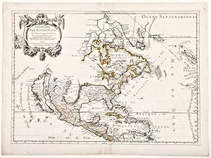
Orbis Vetus, et Orbis Veteris Utraque Continens, Terrarum Tractus Arcticus, et Antarcticus
Published by Paris, 1657
Seller: Alexandre Antique Prints, Maps & Books, Toronto, ON, Canada
Seller Rating:

Map
Condition: Very Good. A handsome 17th century map of the known world, typifying Sanson's scientific style of cartography. Embodying the most up to date information of the period, Sanson's map depicts California as an island, with Antarctica and Australia still largely unknown. A land bridge connects Asia to North America, and touches Japan. A very accurate map for the period. Nicolas Sanson (1600?1667) was a French cartographer, termed by some the creator of French geography, in which he's been called the "father of French cartography." , Size : 380x537 (mm), 14.96x21.14 (Inches), Original Hand Coloring, 0.
-
Single sheet engraved map with full margins, original hand-color in outline (17 x 22 � inches sheet; 26 � x 32 inches framed) A fantastic uncolored map depicting one of the earliest views of the World. This map was created by one of the single most important French cartographers of the 17th century, Nicholas Sanson D'Abbeville. This innovative approach to mapmaking redefined commercial cartography over the next 50 years and signal the beginning end of the Dutch domination over trade. Sanson's noteworthy double hemisphere map of the world featuring his first depiction of the Island of California, using a model for the shape, which would be known as the first Sanson model. The map also provides a good look at the Great Lakes of North America, a region for which Sanson's regional maps would become the most advanced depiction of the cartography of the region for the next 30 years. It is one of the first maps to distinguish the Great Lakes with Lac Superior first named here. Lake Michigan, here called Lac des puans (lake of evil smells), is also introduced here. All five of the Great Lakes were not named until Sanson's 1656 map of New France. Neither Tasmania or New Zealand is shown. A faint outline of Terra Magellanica appears in the south reflecting the uncertainty of the time. Australia is only partially shown, and is labeled Beach after Marco Polo, with place names on the south and west coasts reflecting the Dutch discoveries as they pursued the East Indian spice trade. The map is typical of Sanson's "scientific" style of cartography with no decorative elements. The map depicts a curious northwest Coast of America, separated from California by an unnamed strait a curious omission for someone as meticulous as Sanson. This NorthWest Coast would disappear from his subsequent maps. It was published in conjunction with Pierre Mariette (father and son), who published many of Sanson's work after 1645. For more information on this map, or a warm welcome to see other maps and books of our collection at 72nd Street NYC, please contact Natalie Zadrozna.
-
Single sheet (18 x 23 4/8 inches; 16 x 22 4/8 inches to the neat line). Double-page engraved map of Asia with original hand-colour in outline (a little browned, central vertical crease). A fine and very decorative map by Nicholas Sanson. The Frenchman Nicholas Sanson d'Abbeville (1600-1667) was the founder of the French School of Geography, a school that was unprecedented in its attention to precision and scientific detail and discarded much of the decorative embellishments of previous maps as irrelevant. From Sanson's time in the second half of the seventeenth century until the latter part of the eighteenth century, French geographical conceptions were more influential than those put forward by any other nation. This map gives a nice impression of Spain during its golden age.
-
Les Deux Pole Arctique ou Septentrionale, et Antarctique ou Meidionale [ ]
Published by Paris: 1657., 1657
Single sheet, full margins, original hand-color in outline (17 x 22 � inches sheet; 26 � x 32 inches framed) An attractive double hemisphere map by "the Father of Cartogrpahy", Nicholas Sanson D'Abbeville. This map is based on the polar projections so as to include the northern and southern thirds of the world. The North Pole is found connected to Greenland and Spitzbergen but there is little other detailed coastline in the polar area. Europe, Russia and Canada are delineated. The South Pole is based on the great unknown Southland of Magellan. The most southern tip of South America is shown, and a large land mass ("Terra Incognita") which encompasses the whole of the hemisphere, but nothing else, showing the limited extent of knowledge of these extreme latitudes. Extraordinarily enough, though, the southern projection, which shows little more than the outline of a vast landmass 'Australe et Incogneue', roughly corresponding to Antarctica as we know it today, long before any of it was discovered. Maps by Sanson in original colour are rare, here with a colored outline. Nicolas Sanson (1600-1667) French cartographer who established the first great cartographic dynasty in France. He was tutor to Louis XIV. Sanson published over 300 maps and was a founder of the French school of mapmakers, at a time when the leadership in European cartography passed from the Low Countries to France. For more information on this map, or a warm welcome to see other maps and books of our collection at 72nd Street NYC, please contact Natalie Zadrozna.
-
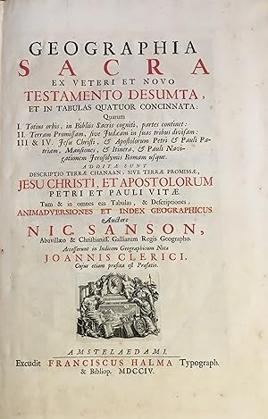
Geographia Sacra ex Veteri et Novo Testamento Desumta .quarum I. Totius orbis, in Bibliis Sacris Cogniti. II. Terram promissam, sive Judaeam .III & IV. Jesu Christi.FOUR PARTS IN ONE VOLUME.
Published by Excudit Franciscus Halma Typograph, Amsterdam, 1704
Book
Hardcover. Condition: Good. 15 pp., Preface, [11 Animadversiones, (notes)] / Index Gepgraphicus et Explicatio Regionum, & Locorum Omnium: 111 pp., / Joannis Clerici Notae in Indicem Geographicum Nic Samsonis: 16 pp., / Judea & Jesu Christi Salvatoris Nostri Vita: 51 pp., [1], engraved title page, foxed outside the illustration border, 4 double-page engraved maps, of which 3 are engraved by F. Halma, the maps are the Francois Halma reissues of Sanson's maps from 1683, contemporary calf, rubbed, marked and soiled, title label on raised & gilt decorated spine, title in black and red ink, title vignette, spine extremities lightly cracked, some pages slightly browned, bookplate of John Marques of Tueeddale Earle of Gifford Viscount Walden, Lord of Hay and Yester &c. verso front cover. Nicolas Sanson 1600-1667.?Born in Abbeville, a town in the Picardy region of France, in 1600, Sanson was the most noted French cartographer in modern history. Mapmaker to Louis XIV, King of France, Sanson endowed his maps with the most recent geographical information as well as the finest and sharpest engraving of the period. His "Cartes Generales de Toutes les Parties du Monde" was the most important single product of French commercial cartography of the seventeenth century. Sanson sparked a renaissance in geographical endeavor in his native country, which had not been a major player on the international cartographic stage since the great Oronce Fin� in the sixteenth century. With this atlas, Sanson laid the foundations of French domination in map production, initiating the so-called "French school of cartography," a school that was unprecedented in its attention to precision and scientific detail and discarded much of the decorative embellishments of previous maps as irrelevant. From Sanson's time in the second half of the seventeenth century until the latter part of the eighteenth century, French geographical conceptions were more influential than those put forward by any other nation. With this landmark atlas, Sanson all but single-handedly caused the center of cartographic innovation to shift from Holland to France.? [Pastoureau Sanson-VD; Shirley T. SAN-2b. Catalogued by Kate Hunter]. Bibliographic references: Rohricht 1129; Laor 692; Tobler 212; Furst III 244. #31734.
-
Amerique Septentrionale
Published by Chez Pierre Mariette, Paris, 1690
Seller: Donald A. Heald Rare Books (ABAA), New York, NY, U.S.A.
Seller Rating:
Map
Copper-engraved map, period hand colouring in outline. Among the most important French maps of North America of the second half of the 17th century, produced by the country's most esteemed family of cartographers. This very influential map was the official successor to Nicolas Sanson's 1650 map of North America. When Nicolas Sanson, regarded as the father of the renaissance of cartography under Louis XIV, died in July, 1667, he left his flourishing business under the charge of his eldest son Guillaume. The younger Sanson continued his father's partnership with the Mariette family, who were prominent Parisian printers. Guillame was determined to publish a new, updated edition of his father's Cartes Generales de toutes parties du Monde, the first French general atlas, originally published in 1657. The map of North America that appeared in the atlas, although masterful, was now considered to be geographically outdated. The present map, which appeared in the second edition of the atlas, featured updated toponymy, and is geographically based on Nicolas Sanson's wall map of 1666 (of which only two copies survive). While California is shown to be an island, in line with popular perception, unlike the map from 1650, it no longer attempts to build a geographical mythology in the place of the Pacific Northwest, which was then totally unknown. Appropriately the magnificent baroque title cartouche, which features swags and ribbons held aloft by putti, has been placed to fill this enigmatic space. Cartographically the map appears to be based on Sanson's maps of "Le Canada, ou Nouvelle France" and "Le Nouveau Mexique, et La Floride." Lake Erie is shown in a recognizable form and the entire Great Lakes network is shown in greater detail than his father's map, although the western lakes are still open-ended. On the East coast, Long Island is shown and the shape of the Outer Banks is improved. Several Indian tribes are identified in New Mexico where the R. del Norte (Rio Grande) mistakenly flows from an interior lake and empties into the Mar Vermeio ou Mer Rouge (Gulf of California). Iceland now appears in the Atlantic, as well as a bit of Britain. The map proved to be highly successful, and was sourced on numerous occasions by other mapmakers. The present copy is an example of Burden's second state of the map, with the date changed to 1690 in the cartouche and with additional place names and other changes: ".with minor alterations Terre de Jesso and Conibas inserted but without a coastline. Detroit d'Anian placed immediately above California and a few changes in spelling . New Albion is inserted in the north of the island, and New York replaces [New] Amsterdam" (Tooley). Burden, The Mapping of North America 404 (second state); McCorkle, New England in Early Printed Maps 669.4; cf. McLaughlin, California as an Island, 45; cf. Wagner, Cartography of the Northwest Coast of America, 399; Tooley, "California as an Island," 9 in Tooley,The Mapping of America.
-

Amerique Septentrionale
Published by Chez Pierre Mariette, Paris, 1669
Seller: Donald A. Heald Rare Books (ABAA), New York, NY, U.S.A.
Seller Rating:
Map
Copper-engraved map, period hand colouring in outline. The most important French map of North America of its generation, produced by the country's most esteemed family of cartographers. This very influential map was the official successor to Nicolas Sanson's 1650 map of North America. When Nicolas Sanson, regarded as the father of the renaissance of cartography under Louis XIV, died in July, 1667, he left his flourishing business in the care of his eldest son Guillaume. The younger Sanson continued his father's partnership with the Mariette family, who were prominent Parisian printers. Guillame was determined to publish a new, updated edition of his father's Cartes Generales de toutes parties du Monde, the first French general atlas, originally published in 1657. The map of North America that appeared in the atlas, although masterful, was now considered to be geographically outdated. The present map, which appeared in the second edition of the atlas, featured updated toponymy, and is geographically based on Nicolas Sanson's wall map of 1666 (of which only two copies survive). While California is shown to be an island, in line with popular perception, unlike the map from 1650, it no longer attempts to build a geographical mythology in the place of the Pacific Northwest, which was then totally unknown. Appropriately the magnificent baroque title cartouche, which features swags and ribbons held aloft by putti, has been placed to fill this enigmatic space. Cartographically the map appears to be based on Sanson's maps of "Le Canada, ou Nouvelle France" and "Le Nouveau Mexique, et La Floride." Lake Erie is shown in a recognizable form and the entire Great Lakes network is shown in greater detail than his father's map, although the western lakes are still open-ended. On the East coast, Long Island is shown and the shape of the Outer Banks is improved. Several Indian tribes are identified in New Mexico where the R. del Norte (Rio Grande) mistakenly flows from an interior lake and empties into the Mar Vermeio ou Mer Rouge (Gulf of California). Iceland now appears in the Atlantic, as well as a bit of Britain. The map proved to be highly successful, and was sourced on numerous occasions by other mapmakers. The present copy is an example of Burden's first state of the map; a second state would be issued in 1690. Burden, The Mapping of North America I, 404; (first state) McCorkle, New England in Early Printed Maps, 669.4; McLaughlin, California as an Island, 45; Wagner, Cartography of the Northwest Coast of America, 399; Tooley, "California as an Island," 8 in Tooley,The Mapping of America.


![Seller image for La Germanie en quatre grands peuples [This title has been overlaid onto the original title of the map: "Germania Antiqua"] for sale by Antiqua Print Gallery](https://pictures.abebooks.com/inventory/md/md31102247566.jpg)
![Seller image for L'Allemagne par ses Estats, Principaut�s &. [This title has been overlaid onto the original title of the map: "Carte Generale de l'Empire d'Allemagne et Pays Circonvoisins."] for sale by Antiqua Print Gallery](https://pictures.abebooks.com/inventory/md/md31102250068.jpg)
![Seller image for L'Allemagne par cercles [This title has been overlaid onto the original title of the map: "Carte Generale de l'Empire d'Allemagne et Pays Circonvoisins."] for sale by Antiqua Print Gallery](https://pictures.abebooks.com/inventory/md/md31102252921.jpg)
![Seller image for La Germanie en moyens peuples [This title has been overlaid onto the original title of the map: "Germania Antiqua"] for sale by Antiqua Print Gallery](https://pictures.abebooks.com/inventory/md/md31102253909.jpg)
![Seller image for L'Allemagne en General divis�e en trois principales parties [This title has been overlaid onto the original title of the map: "Carte Generale de l'Empire d'Allemagne et Pays Circonvoisins."] for sale by Antiqua Print Gallery](https://pictures.abebooks.com/inventory/md/md31102253910.jpg)
![Seller image for L'Allemagne par archeves. Ch�s et Evesch�s [This title has been overlaid onto the original title of the map: "Carte Generale de l'Empire d'Allemagne et Pays Circonvoisins."] for sale by Antiqua Print Gallery](https://pictures.abebooks.com/inventory/md/md31102253911.jpg)