Order Total (1 Item Items):
Shipping Destination:

Robert Morden (470 results)
Skip to main search results
Product Type
- All Product Types
- Books (190)
- Magazines & Periodicals
- Comics
- Sheet Music
- Art, Prints & Posters (1)
- Photographs
- Maps (279)
-
Manuscripts &
Paper Collectibles
Condition
Binding
Collectible Attributes
- First Edition (43)
- Signed (3)
- Dust Jacket (1)
- Seller-Supplied Images (405)
- Not Printed On Demand (445)
Free Shipping
Seller Location
Seller Rating
-

Trendsetters : The World's Leading Experts Reveal Top Trends to Help You Achieve Health, Wealth and Success
Published by Celebrity Press, 2011
ISBN 10: 0983340463ISBN 13: 9780983340461
Book
Condition: Good. Used book that is in clean, average condition without any missing pages.
-
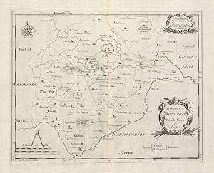
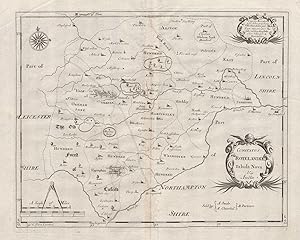
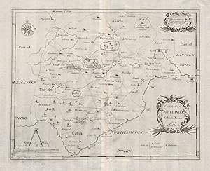
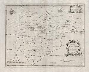
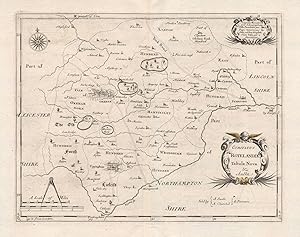
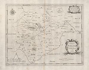
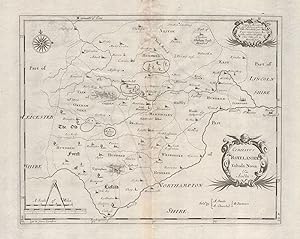
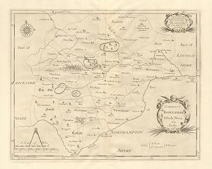
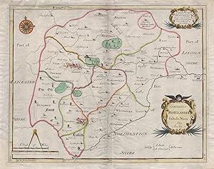
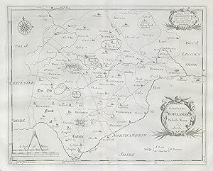
Condition: Good. Rutland. 'COMITATUS ROTELANDIAE' by ROBERT MORDEN. Oakham & Uppingham c1753 map. Double page folio copperplate engraved map; Robert Morden; "Sold by A Swale A Churchil & Partners". (c1753). 29.0 x 37.5cm, 11.5 x 14.75 inches; this is a folding map. Condition: Good. The map has been trimmed close to the borders of the map. Very tight margins. There is nothing printed on the reverse side, which is plain.
-
Condition: Good. Rutland county map 'COMITATUS ROTELANDIAE' by ROBERT MORDEN. Uppingham 1695. Double page folio copperplate engraved map; Robert Morden; "Sold by A Swale A Churchil & Partners". (1695). 32.5 x 40.0cm, 12.75 x 15.75 inches; this is a folding map. Condition: Good. There is nothing printed on the reverse side, which is plain.
-
Condition: Good. Rutland. 'COMITATUS ROTELANDIAE' by ROBERT MORDEN. Camden's Britannia c1695 map. Double page folio copperplate engraved map; Robert Morden; "Sold by A Swale A Churchil & Partners". (c1695). 31.5 x 39.5cm, 12.5 x 15.5 inches; this is a folding map. Condition: Good. There is nothing printed on the reverse side, which is plain.
-
Condition: Good. Rutland. 'COMITATUS ROTELANDIAE' by ROBERT MORDEN. Oakham Uppingham 1695 map. Double page folio copperplate engraved map; Robert Morden; "Sold by A Swale A Churchil & Partners". (1695). 32.0 x 39.5cm, 12.75 x 15.5 inches; this is a folding map. Condition: Good. Small hole along centrefold, c2mm diameter. There is nothing printed on the reverse side, which is plain.
-
Condition: Good. Rutland county map 'COMITATUS ROTELANDIAE' by R. MORDEN. Camden's Britannia 1695. Double page folio copperplate engraved map; Robert Morden; "Sold by A Swale A Churchil & Partners". (1695). 32.5 x 40.5cm, 12.75 x 15.75 inches; this is a folding map. Condition: Good. There is nothing printed on the reverse side, which is plain.
-
Condition: Good. Rutland. 'COMITATUS ROTELANDIAE' by ROBERT MORDEN. Uppingham & Oakham 1753 map. Double page folio copperplate engraved map, with a small amount of discreet hand colour; Robert Morden; "Sold by A Swale A Churchil & Partners". (1753). 32.5 x 41.0cm, 12.75 x 16 inches; this is a folding map. Condition: Good. Minor offsetting -text and/or images from the facing page have left an impression on the print. There is nothing printed on the reverse side, which is plain.
-
Condition: Good. Antique Rutland county map 'COMITATUS ROTELANDIAE' by ROBERT MORDEN 1695. Double page folio copperplate engraved map; Robert Morden; "Sold by A Swale A Churchil & Partners". (1695). 32.5 x 41.0cm, 12.75 x 16.25 inches; this is a folding map. Condition: Good. There is nothing printed on the reverse side, which is plain.
-
Condition: Good. Rutland. 'COMITATUS ROTELANDIAE' by ROBERT MORDEN. Uppingham & Oakham 1695 map. Double page folio copperplate engraved map; Robert Morden; "Sold by A Swale A Churchil & Partners". (1695). 32.5 x 41.0cm, 12.75 x 16 inches; this is a folding map. Condition: Good. Minor offsetting -text and/or images from the facing page have left an impression on the print. There is nothing printed on the reverse side, which is plain.
-

PAP. Condition: New. New Book. Shipped from UK. Established seller since 2000.
More buying choices from other sellers on AbeBooks
New offers from US$ 23.56
-
Condition: Good. Rutland. 'COMITATUS ROTELANDIAE' by ROBERT MORDEN. Oakham & Uppingham 1772 map. Double page folio copperplate engraved map; Robert Morden; "Sold by A Swale A Churchil & Partners". (From Gibson's English version of Camden's Britannia, original published in 1695; This map from the scarce fourth edition, published 1772.). 32.5 x 40.5cm, 12.75 x 16 inches; this is a folding map. Condition: Good. The image shown may have been taken from a different example of this map than that which is offered for sale. The map you will receive is in good condition but there may be minor variations in the condition from that shown in the image. There is nothing printed on the reverse side, which is plain.
-
Condition: Good. Rutland. 'COMITATUS ROTELANDIAE'. MORDEN. Oakham & Uppingham. Coloured 1695 map. Double page folio copperplate engraved map with original hand colouring; Robert Morden; "Sold by A Swale A Churchil & Partners". (1695). 30.5 x 39.0cm, 12 x 15.25 inches; this is a folding map. Condition: Good. Old crease across bottom left hand corner. Small repaired tear in top margin not extending up to or inside the printed area. There is nothing printed on the reverse side, which is plain.
-
Condition: Good. Rutland. 'COMITATUS ROTELANDIAE' by ROBERT MORDEN. Uppingham & Oakham 1722 map. Double page folio copperplate engraved map; Robert Morden; "Sold by A Swale A Churchil & Partners". (From Gibson's English version of Camden's Britannia, originally published in 1695; This print from the second 1722 edition). 32.5 x 40.5cm, 12.75 x 16 inches; this is a folding map. Condition: Good. There is nothing printed on the reverse side, which is plain.
-
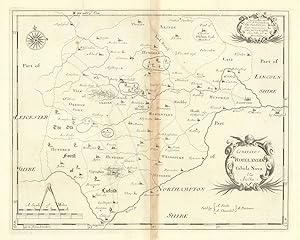
Condition: Fair. Rutland. 'COMITATUS ROTELANDIAE' by ROBERT MORDEN. Uppingham & Oakham 1695 map. Double page folio copperplate engraved map; Robert Morden; "Sold by A Swale A Churchil & Partners". (1695). 32.5 x 40.5cm, 12.75 x 16 inches; this is a folding map. Condition: Fair: Repaired wormholes straddling top border. Light toning along centrefold. There is nothing printed on the reverse side, which is plain.
-
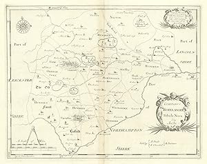
Condition: Good. Rutland. 'COMITATUS ROTELANDIAE' by ROBERT MORDEN. Uppingham & Oakham 1722 map. Double page folio copperplate engraved map; Robert Morden; "Sold by A Swale A Churchil & Partners". (From Gibson's English version of Camden's Britannia, originally published in 1695; This print from the second 1722 edition). 32.5 x 40.5cm, 12.75 x 16 inches; this is a folding map. Condition: Good. The image shown may have been taken from a different example of this map than that which is offered for sale. The map you will receive is in good condition but there may be minor variations in the condition from that shown in the image. There is nothing printed on the reverse side, which is plain.
-
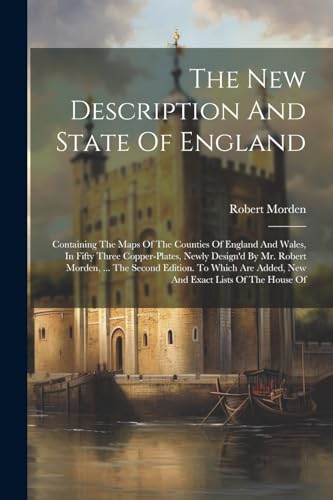
The The New Description And State Of England
Published by Legare Street Press, 2023
ISBN 10: 1022601512ISBN 13: 9781022601512
Book Print on Demand
PAP. Condition: New. New Book. Shipped from UK. THIS BOOK IS PRINTED ON DEMAND. Established seller since 2000.
More buying choices from other sellers on AbeBooks
New offers from US$ 28.98
-
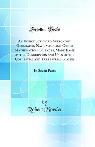
Geography Rectified, or a Description of the World, in All Its Kingdoms,
Published by Forgotten Books, 2018
ISBN 10: 1333827350ISBN 13: 9781333827359
Book Print on Demand
Paperback. Condition: New. Print on Demand. Excerpt from Geography Rectified, or a Description of the World, in All Its Kingdoms, Provinces, Countries, Islands, Cities, Towns, Seas, Rivers, Bayes, Capes, Ports, Their Ancient and Present Names, Inhabitants, Situations, Histories, Customs, Governments, Etc. About the Publisher, Forgotten Books publishes hundreds of thousands of rare and classic books. This book is a reproduction of an important historical work. Forgotten Books uses state-of-the-art technology to digitally reconstruct the work, preserving the original format whilst repairing imperfections present in the aged copy. In rare cases, an imperfection in the original, such as a blemish or missing page, may be replicated in our edition. We do, however, repair the vast majority of imperfections successfully; any imperfections that remain are intentionally left to preserve the state of such historical works. This text has been digitally restored from a historical edition. Some errors may persist, however we consider it worth publishing due to the work's historical value. The digital edition of all books may be viewed on our website before purchase. print-on-demand item.
More buying choices from other sellers on AbeBooks
New offers from US$ 24.27
-
PAP. Condition: New. New Book. Shipped from UK. THIS BOOK IS PRINTED ON DEMAND. Established seller since 2000.
More buying choices from other sellers on AbeBooks
New offers from US$ 31.32
Used offers from US$ 36.70
Also find Softcover
-
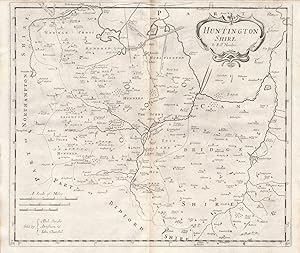
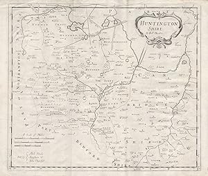
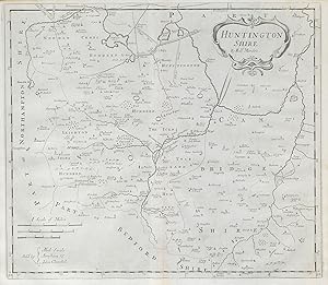
Condition: Good. Huntingdonshire.'HUNTINGTON SHIRE' by ROBERT MORDEN.Camden's Britannia 1722 map. Double page folio copperplate engraved map; Robert Morden; "Sold by Abel Swale Awnsham & Iohn Churchil [John Churchill]". (1722). 37.5 x 44.5cm, 14.75 x 17.5 inches; this is a folding map. Condition: Good. Minor offsetting -text and/or images from the facing page have left an impression on the print. There is nothing printed on the reverse side, which is plain.
-
HRD. Condition: New. New Book. Shipped from UK. Established seller since 2000.
More buying choices from other sellers on AbeBooks
New offers from US$ 32.70
-
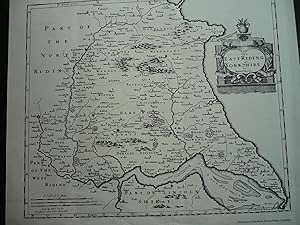
Map: The East Riding of York Shire 1695.
Published by Holderness Publications, Burton Pidsea. N.d. (Ca. 1980s)., 1980
Map
No Binding. Condition: Very Good. Limited Edition. Reproduction in VG condition, large folio, one page. This map is reproduced from Gibson's Edition of Camden's Britannia, 1695. size is 16.5"x14", and the overall size of the sheet is 18.5"x16". Great for framing.
-

Map: The North Riding of York Shire 1695.
Published by Holderness Publications, Burton Pidsea. N.d. (Ca. 1980s)., 1980
Map
No Binding. Condition: Fine. Limited Edition. Reproduction of Morden's map of 1695 in Fine condition, one page, large folio. Size is 16.5"x14" and the overall size is 19"x15". Ideal for framing.
-
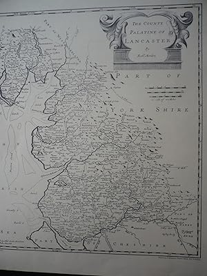
Map: The County Palatine of Lancaster 1695.
Published by Holderness Publications, Burton Pidsea. N.d. (Ca. 1980s)., 1980
Map
No Binding. Condition: Fine. Limited Edition. Reproduction of Morden's map of 1695 in Fine condition, one page, large folio. Size is 14"x16.25", overall size of the sheet is 15"x19". Ideal for framing.
-
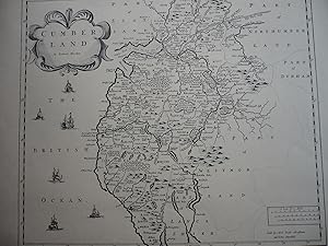
Map: Cumberland 1695.
Published by Holderness Publications, Burton Pidsea. N.d. (Ca. 1980s)., 1980
Map
No Binding. Condition: Fine. Limited Edition. Reproduction of Morden's map of 1695 in Fine condition, one page, large folio. Size is 16.5"x14", overall size of the sheet is 19"x15". Ideal for framing.
-

Map: Northumberland 1695.
Published by Holderness Publications, Burton Pidsea. N.d. (Ca. 1980s)., 1980
Map
No Binding. Condition: Fine. Limited Edition. Reproduction of Morden's 1695 map in VG+ condition, one page, large folio. Size is 14"x16.5", overall size of the sheet is 15"x19". Ideal for framing.
-
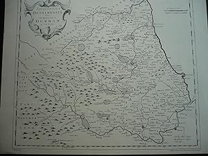
Map: Episcopaius Dunelmensis Vulgo The Bishoprick of Durham 1695.
Published by Holderness Publications, Burton Pidsea. N.d. (Ca. 1980s)., 1980
Map
No Binding. Condition: Fine. Limited Edition. Reproduction of Morden's map of 1695 in Fine condition, one page, large folio. Size is 16.5"14.5", overall size of the sheet is 19"x15". Ideal for framing.
-
Condition: Good. Huntingdonshire & NW Cambridgeshire.'HUNTINGTON SHIRE' by ROBERT MORDEN 1722 map. Double page folio copperplate engraved map; Robert Morden; "Sold by Abel Swale Awnsham & Iohn Churchil [John Churchill]". (1722). 38.0 x 45.0cm, 15 x 17.75 inches; this is a folding map. Condition: Good. Damp stain in top margin not extending upto or inside the printed area. There is nothing printed on the reverse side, which is plain.
-
Condition: Good. 'HUNTINGTON SHIRE' Huntingdonshire by ROBERT MORDEN. Camden's Britannia 1722 map. Double page folio copperplate engraved map; Robert Morden; "Sold by Abel Swale Awnsham & Iohn Churchil [John Churchill]". (From Gibson's English version of Camden's Britannia, originally published in 1695; This print from the second 1722 edition). 39.0 x 43.0cm, 15.25 x 17 inches; this is a folding map. Condition: Good. There is nothing printed on the reverse side, which is plain.
-
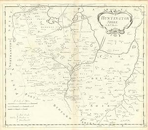
Condition: Good. 'HUNTINGTON SHIRE' Huntingdonshire by ROBERT MORDEN. Camden's Britannia 1722 map. Double page folio copperplate engraved map; Robert Morden; "Sold by Abel Swale Awnsham & Iohn Churchil [John Churchill]". (From Gibson's English version of Camden's Britannia, originally published in 1695; This print from the second 1722 edition). 39.0 x 43.0cm, 15.25 x 17 inches; this is a folding map. Condition: Good. The image shown may have been taken from a different example of this map than that which is offered for sale. The map you will receive is in good condition but there may be minor variations in the condition from that shown in the image. There is nothing printed on the reverse side, which is plain.
-

Condition: Fair. 'HUNTINGTON SHIRE' Huntingdonshire by ROBERT MORDEN. Camden's Britannia 1695 map. Double page folio copperplate engraved map; Robert Morden; "Sold by Abel Swale Awnsham & Iohn Churchil [John Churchill]". (1695). 39.0 x 43.0cm, 15.25 x 17 inches; this is a folding map. Condition: Fair: Two small repaired wormholes straddling top border of map. Light toning along centrefold. There is nothing printed on the reverse side, which is plain.