Order Total (1 Item Items):
Shipping Destination:

William Faden 1749 1836 (26 results)
Skip to main search results
Product Type
- All Product Types
- Books (24)
- Magazines & Periodicals
- Comics
- Sheet Music
- Art, Prints & Posters
- Photographs
- Maps (2)
-
Manuscripts &
Paper Collectibles
Condition
Binding
Collectible Attributes
Free Shipping
Seller Location
Seller Rating
-

Atlas Minimus Universalis, or, A Geographical Abridgement Ancient and Modern of the Several Parts of the Earth: in Fifty-five Maps Composed Principall (Paperback or Softback)
Published by Legare Street Press 9/9/2021, 2021
ISBN 10: 1014675782ISBN 13: 9781014675781
Book
Paperback or Softback. Condition: New. Atlas Minimus Universalis, or, A Geographical Abridgement Ancient and Modern of the Several Parts of the Earth: in Fifty-five Maps Composed Principall 0.39. Book.
More buying choices from other sellers on AbeBooks
New offers from US$ 20.58
-

A map of the Northern Part of France, with the Adjacent Netherlands, and the Course of the Rhine from Upper Alsace to Dusseldorf; to facilitate the Knowledge of the Operations carried on by The Austrian Armies against the French Conventional Troops. Gro�e Landkarte von Nordfrankreich und den Niederlanden mit dem Rheinlauf vom Elsass bis D�sseldorf 1795
Published by London: W Faden, 1795
Seller: historicArt Antiquariat & Kunsthandlung, Wiesbaden-Breckenheim, Germany
Seller Rating:

Map First Edition Signed
1. sehr gro�e Landkarte auf r�ckseitig unbedrucktem B�ttenkarton, sehr detailreiche Landkarte, von alter Hand pr�zise grenzkoloriert, mit franz�sischem, deutschen und britischem Meilenzeiger unter der Legende oben rechts, bildliche Darstellung ca. 54 x 78 cm, Blattgr��e ca. 58 x 77 cm, gegl�ttete Mittelfalz, ansonsten sauber und gut erhalten, sehr seltene Karte unmittelbar nach der franz�sischen Revolution, gestochen und ver�ffentlicht kurioserweise, um den �sterreichischen Truppen gegen die franz�sischen Truppen (Revolutionsarmeen) zu helfen - gro�er und/oder schwerer Artikel mit zus�tzlichen Kosten f�r Versand und Versicherung - heavy and/or oversized item with additional costs for shipping and insurance - please ask us before you order this article 2100 gr.
-
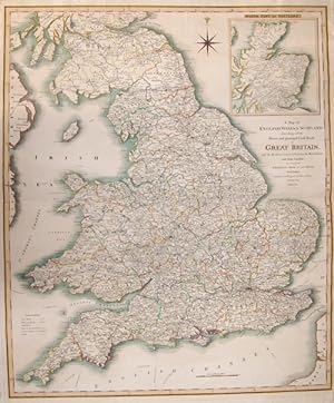
A Map of England, Wales + Scotland, describing all the Direct and principal Cross Roads in Great Britain, with the Distances measured between the.
Published by Artist: Faden William ( - 1836 ) London ; issued in: Wales ; dated: 1801; - William Faden (1749 ? 1836) was an English cartographer and a publisher of maps He was the royal geographer to King George III He replaced Thomas Jeffreys in that roleThe title of -geographer to the king- was given to various people in the 18th century including John Senex Herman Moll Emmanuel Bowen and Thomas Jeffreys All of these men including William Faden were engravers and publishers not scholars or academics Their part was to publish and supply maps to the crown and parliament William Faden printed the North American Atlas in 1777 and "it became the most important atlas chronicling the Revolution's battles" There were 29 maps in the atlas and they included det, 1749
Seller: Antique Sommer& Sapunaru KG, M�nchen, Germany
Seller Rating:

Technic: Steel engraving; colorit: original colored; condition: Perfect condition, size (in cm): 71,5 x 60; - Map depicts Englan, Wales and Scottland with all the mainstreets and major cities. With a decorativie wind rose and on an inset map Scottland.
-
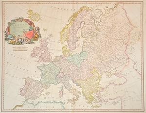
Europe, Exhibiting its principal states.
Published by Artist: Faden William ( - 1836 ) London ; issued in: London ; dated: 1792; - William Faden (1749 ? 1836) was an English cartographer and a publisher of maps He was the royal geographer to King George III He replaced Thomas Jeffreys in that roleThe title of -geographer to the king- was given to various people in the 18th century including John Senex Herman Moll Emmanuel Bowen and Thomas Jeffreys All of these men including William Faden were engravers and publishers not scholars or academics Their part was to publish and supply maps to the crown and parliament William Faden printed the North American Atlas in 1777 and "it became the most important atlas chronicling the Revolution's battles" There were 29 maps in the atlas and they included de, 1749
Seller: Antique Sommer& Sapunaru KG, M�nchen, Germany
Seller Rating:
Technic: Copper print; colorit: original colored; condition: Some restoration at centerfold, size (in cm): 51,5 x 66; - Map shows total Europe with the formaer frontiers.
-
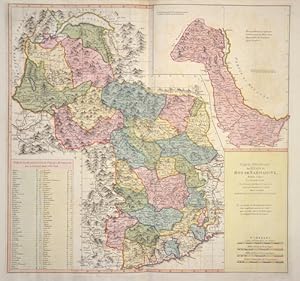
Carte G�neral de Etats du Roi de Sardaigne
Published by Artist: Faden William ( - 1836 ) London ; issued in: London ; dated: 1783; - William Faden (1749 ? 1836) was an English cartographer and a publisher of maps He was the royal geographer to King George III He replaced Thomas Jeffreys in that roleThe title of -geographer to the king- was given to various people in the 18th century including John Senex Herman Moll Emmanuel Bowen and Thomas Jeffreys All of these men including William Faden were engravers and publishers not scholars or academics Their part was to publish and supply maps to the crown and parliament William Faden printed the North American Atlas in 1777 and "it became the most important atlas chronicling the Revolution's battles" There were 29 maps in the atlas and they included de, 1749
Seller: Antique Sommer& Sapunaru KG, M�nchen, Germany
Seller Rating:
Technic: Copper print; colorit: colored; condition: Very good, size (in cm): 51 x 54; - map of the properties of the King of Sardinia, south of Lake Geneva.
-

Eastern Hemisphere
Published by Artist: Faden William ( - 1836 ) London ; issued in: London ; ca: 1790; - William Faden (1749 ? 1836) was an English cartographer and a publisher of maps He was the royal geographer to King George III He replaced Thomas Jeffreys in that roleThe title of -geographer to the king- was given to various people in the 18th century including John Senex Herman Moll Emmanuel Bowen and Thomas Jeffreys All of these men including William Faden were engravers and publishers not scholars or academics Their part was to publish and supply maps to the crown and parliament William Faden printed the North American Atlas in 1777 and "it became the most important atlas chronicling the Revolution's battles" There were 29 maps in the atlas and they included detai, 1749
Seller: Antique Sommer& Sapunaru KG, M�nchen, Germany
Seller Rating:
Technic: Copper print; colorit: original colored; condition: Perfect condition, size (in cm): 58,5 x 57 cm; - Map shows the eastern hemisphere with Europe, Africa, Asia, Southeast Asia and Australia.
-
Nouvelle Carte de la Suisse dans laquelle sont exactement distingues Les Treize Cantons,.
Published by Artist: Faden William ( - 1836 ) London ; issued in: London ; dated: 1799; - William Faden (1749 ? 1836) was an English cartographer and a publisher of maps He was the royal geographer to King George III He replaced Thomas Jeffreys in that roleThe title of -geographer to the king- was given to various people in the 18th century including John Senex Herman Moll Emmanuel Bowen and Thomas Jeffreys All of these men including William Faden were engravers and publishers not scholars or academics Their part was to publish and supply maps to the crown and parliament William Faden printed the North American Atlas in 1777 and "it became the most important atlas chronicling the Revolution's battles" There were 29 maps in the atlas and they included de, 1749
Seller: Antique Sommer& Sapunaru KG, M�nchen, Germany
Seller Rating:
Technic: Copper print; colorit: original colored; condition: Some folds, size (in cm): 63 x 85; - Decorative map of Swizzerland with two cartouches, a view and hight descriptuion of the mountains in Swizerland.
-
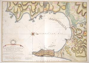
Plan of the Bay, Rock and Town of Gibraltar, from an Actual Survey by an Officer who was at Gibraltar from 1769 to 1775.
Published by Artist: Faden William ( - 1836 ) London ; issued in: London ; ca: 1783; - William Faden (1749 ? 1836) was an English cartographer and a publisher of maps He was the royal geographer to King George III He replaced Thomas Jeffreys in that roleThe title of -geographer to the king- was given to various people in the 18th century including John Senex Herman Moll Emmanuel Bowen and Thomas Jeffreys All of these men including William Faden were engravers and publishers not scholars or academics Their part was to publish and supply maps to the crown and parliament William Faden printed the North American Atlas in 1777 and "it became the most important atlas chronicling the Revolution's battles" There were 29 maps in the atlas and they included detai, 1749
Seller: Antique Sommer& Sapunaru KG, M�nchen, Germany
Seller Rating:
Technic: Copper print; colorit: gouache; condition: Perfect condition, size (in cm): 51,5 x 73 cm; - Map shows the Bay of Gibraltar, the city of Gibraltar and the coast with upstream sailing ships and a wind rose.
-
Le Petit Neptune Francais; or, French Coasting Pilot for the Coast of Flanders, Channel, Bay of Biscay and Mediterranean, to Which is Added, the Coast of Italy from the River Var to Orbitello; with the Gulf of Naples, and the Island of Corsica
Published by for W. Faden, London, 1793
Seller: Alcuin Books, ABAA/ILAB, Scottsdale, AZ, U.S.A.
Seller Rating:
First Edition
First Edition. Quarto. 3rd printing revised and enlarged. 147pp., (8)pp index. Engraved frontispiece view of the Tower of Cordouan, 42 folding plates of charts, plans and maps. "Many of the charts in Faden's Le Petit Neptune follow those in Thomas Jeffery's atlas of the same name of thirty years' earlier. They are however newly engraved with Faden's imprint. and a plate number in the upper right corner" (Shirley). The work was issued as a response to the revolutionary upheavals in France, in anticipation of war with France. Earlier rebinding of 3/4 brown cloth over green marbled paper covered boards, endpapers renewed, red spine label gilt, there is a crack along the gutter of frontispiece and title page which evidently was done for some odd reason by binder(?) some toning or scattered foxing to plates, some off-setting from plates. The bottom edges of some plates creased. A very good copy. From the library of Sir Francis Fletcher Vane Armiger Commander of the Noble Order of Christ with his bookplates. Among the most pointless of deaths in Easter Week of 1916 was that of the Irish pacifist and feminist Francis Sheehy-Skeffington. The attempt by the British to cover up the murders was thwarted by Major Francis Fletcher-Vane, who had been ordered to bury the bodies. Vane took his complaints to the highest authorities and was discharged from the army later that year for his part in the affair.
-
Plan of the Position which the Army under Lt. Genl. Buroione Took at Saratoga on the 10th of September 1777 and in which it Remained till the Convention was Signed.
Published by London: Bargoyne, 1793., 1793
"Single sheet (10 x 20 � inches) (Staining, paper tone) An excellent and important early battle plan, showing the position of the British and American Troops following the second battle of Saratoga. General John Burgoyne (24 February 1722 - 4 August 1792) was a British army officer, politician and dramatist. He first saw action during the Seven Years' War when he participated in several battles, most notably during the Portugal Campaign of 1762. John Burgoyne is best known for his role in the American Revolutionary War. He designed an invasion scheme and was appointed to command a force moving south from Canada to split away New England and end the rebellion. Burgoyne advanced from Canada but his slow movement allowed the Americans to concentrate their forces. Instead of coming to his aid according to the overall plan, the British Army in New York City moved south to capture Philadelphia. Surrounded, Burgoyne fought two small battles near Saratoga to break out. Following the first battle, Burgoyne took a defensive position, while the Americans withdrew to wait for his next move. Burgoyne marched out and was attacked by Gates on both flanks. While his army survived the battle, the consequences were quite severe. With his supplies running low and his escape blocked by the American, Burgoyne set up a final defensive camp near Saratoga, where he remained until he negotiated terms of surrender on Oct. 17, 1777. The battle was a major turning point in the American Revolution, as it was the American's first major victory and contributed significantly to the French decision to back the Americans. " was a great turning point of the war, because it won for Americans the foreign assistance which was the last element needed for victory". (Morgan) Originally engraved by Faden, the map shows the final encampment of Burgoyne's army, including troop placements and defenses across the Fish Kill from Saratoga and the American positions surrounding the British, including Gates' main army to the south of the Fish Kill, Morgan's riflemen in the woods to the west, and General Fellows troops blocking the escape route across the Hudson on the east. For more information on this map, or a warm welcome to see other maps and books of our collection at 72nd Street NYC, please contact Natalie Zadrozna.".
-
A Plan of the Action at Breeds Hill on the 17th of June 1775, Pl. 1.
Published by New York: C Smith, c. 1796., 1796
Single sheet (9 � x 9 inches) (Edge chipped, light stain bottom, age tone) Rare Revolutionary War battle plan showing the battle of Breeds Hill (erroneously called Bunkers Hill) from Charles Smith's Monthly Military Repository, the earliest obtainable American engraved plans of the battle. This rare engraving from Charles Smith's Monthly Military Repository is the first detailed plan of the battle of Bunker Hill to be printed in the United States. The plan provides a highly detailed view of the battle derived from William Faden's Plan of the Action at Bunkers Hill. The major differences are the correction of "Bunkers" to "Breeds" Hill in the title and the consolidation of the information on a single sheet (Faden employed an overlay to distinguish the initial and later phases of the battle.) After the Americans fortified Breed's Hill on the Charlestown peninsula, giving their artillery command over much of Boston and its approaches, the British attacked the American positions. Overconfident, the British ferried troops across the Charles and attacked the American emplacement head on. After fierce resistance, the Americans were overwhelmed by the British, supported by artillery bombardment from three sides. Smith's Repository (1796-1797) included instruction on military strategy, conduct, and clothing, extracts from histories of European wars, and more importantly, descriptions of American Revolutionary battles. Most of the descriptions for the American battles were taken from the writings of Baron Steuben and Gen. Horatio Gates. Included were a series of revolutionary battle plans based on prototypes published in London. In 1797, Smith reissued the American material from the Repository in a single volume under the title 'The American War'. For more information on this map, or a warm welcome to see other maps and books of our collection at 72nd Street NYC, please contact Natalie Zadrozna.
-
Le Petit Neptune Fran�ais; or, French Coasting Pilot, for the Coast of Flanders, Chanel, Bay of Biscay, and Mediterranean. To which is added, The Coast of Italy from the River var to Orbitello; with the Gulf of Naples, and the illustrated with charts, plans, &c.
Published by Printed for W. Faden, 1793
Seller: Librer�a Miguel Miranda, Lope de Vega n.� XIX, Madrid, M, Spain
Seller Rating:
Book First Edition
Condition: Fair / Aceptable. London: Printed for W. Faden, Geographer to his Majesty, and to his Royal Highness the Prince of Walles, Charing-Cross, 1793.- XVI,147 p., [4 h.]: Grabada al cobre ante la portada 1 l�mina representando la "Towe of Cordouan" + 43 mapas grabados al cobre (de los que 41 son plegados y 2 a pleno folio. Siendo el �ltimo un mapa plegado de 60 x 45,5 cm. que representa al puerto de Plymouth); In Folio (29,3 x 23,6 cm.); Texto en ingl�s; Enc. en Media Piel pergamino �poca.- Este atlas original del gran ge�grafo franc�s Georges Boissaye Du Bocage (1626-1696), cuya 1� Edici�n fue publicada en Londres, impresa por T. Jefferys, en 1761, y la 1� edici�n francesa creemos que se public� en en Paris, impresa por S. Jorry, 1765. Constituye un atlas y portulano magistral para su �poca. Adem�s la edici�n que nosotros ofrecemos esta publicada e impresa por el renombrado ge�grafo ingles William Faden (1749-1836), que fue cart�grafo del Rey Jorge III, que sucedi� en el cargo al tambi�n renombrado ge�grafo Thomas Jeffreys (1719 1771).- ES OBRA MUY RARA. La encuadernaci�n se encuentra algo fatigada, aunque es de la �poca, el primer grabado y la portada algo sucios y con diversas se�ales de humedad, adem�s la portada est� reforzada de �poca en su margen interno, sin que afecte a ninguna parte del texto. El mapa 6 y el 14 tienen motas de �xido y el �ltimo mapa de Plymouth con las esquinas cortadas, aunque en muy buen estado. Salvo los defectos descritos, en general, la obra se encuentra completa y en muy aceptable estado, con los mapas perfectos, salvo los dos indicados. Book in english GEOGRAF�A, GU�AS Y ATLAS DEL EXTRANJERO.
-
Le Petit Neptune Francais: or, French Coasting Pilot.
Published by London: for W. Faden, 1793., 1793
FADEN, William (1749-1836). Le Petit Neptune Francais: or, French Coasting Pilot, for the coast of Flanders, Channel, Bay of Biscay, and Mediterranean, to which is added the coast of Italy from the River Var To Orbitello: with the Gulf of Naples and the island of Corsica. London: for W. Faden, 1793. 4to (10 4/8 x 8 2/8 inches). Engraved frontispiece showing the Tower of Cordouan, 37 fine folding engraved charts, and 2 full-page, of the coast of France, 3 folding plates of coastal profiles (short separation at fold to map of "L'Orient to St. Gilles", occasional light spotting and offsetting). Contemporary half tan sprinkled calf, marbled paper boards, yellow edges (extremities scuffed, chipped with minor loss at the head and foot of the spine). In anticipation of a war with revolutionary France, William Faden re-engraved charts that had appeared in Thomas Jeffery's "Le Petit Neptune Francois" of 1761.Initially Britain did not involve itself in the French Revolution, but in 1793 France declared war, and for the next 22 years the Royal Navy reigned supreme. The first major naval battle of the conflict, fought on the first of June, 1794, was the Battle of the First of June, also called the Battle of the Glorious First of June, or the Battle of Ushant. Fought between the French and the British in the Atlantic Ocean about 430 miles west of the Breton island of Ouessant, or Ushant, the battle arose out of an attempt by the British Channel fleet, under Admiral Earl Richard Howe, to intercept a grain convoy from the United States that was being escorted into Brest, France, by the French Atlantic fleet, under Rear Admiral Louis Thomas Villaret-Joyeuse. The next, Battle of the Nile, also called Battle of Aboukir Bay, was fought on August 1st, 1798). One of the greatest victories of the British Admiral Horatio Nelson, it was fought between the British and French fleets in Abu Qir Bay, near Alexandria, Egypt. Arguably the most famous naval conflict, almost of all time, was the Battle of Trafalgar, "which established British naval supremacy for more than 100 years" (Encyclopedia Britannica). Fought west of Cape Trafalgar, Spain, between C�diz and the Strait of Gibraltar, a fleet of 33 ships (18 French and 15 Spanish) under Admiral Pierre de Villeneuve fought, and lost, against a British fleet of 27 ships commanded by Admiral Horatio Nelson. In 1764, Faden was apprenticed to the Fleet Street engraver James Wigley. By "1773 he was in partnership with the family of the recently deceased map maker Thomas Jefferys, at Jefferys's premises on the corner of St Martin's Lane. The partnership with the younger Jefferys was dissolved in 1776, the same year in which Faden became an active member of the Society of Civil Engineers (later the Smeatonian Society of Civil Engineers), the influential dining club of John Smeaton and other leading practical men of the day founded in 1771. "In the years of the American wars Faden came to prominence with maps and atlases of considerable historical note, some of the materials for which survive in the Library of Congress. He is glimpsed at this time as the very accurate, industrious young man commended by Thomas Pownall. In 1783 his father's will enabled him to establish full control of the business. That same year he was appointed to the place and quality of Geographer in Ordinary to his Majesty . "Systematic in the acquisition of the best available maps, Faden developed the most competent cartographic service of the period. His was an international concern, in contact with map makers throughout Europe. He supplied government departments and commissioned fresh surveys. A gold medallist of the Society of Arts in 1796, his activities foreshadowed the emergence of national cartographic agencies. He brought out the first published Ordnance Survey map, An Entirely New & Accurate Survey of the County of Kent (1801). Some of his plates were likewise adopted as official Admiralty charts. When he moved at this time.
-
MAP PRINTED ON SILK / OBJECT D'ART / ALEXANDRIA, EGYPT / NAPOLEONIC CAMPAIGN IN EGYPT: A Plan of the Operations of the British Forces in Egypt from the Landing in Aboukir Bay on the 8th of March to the Battle of Alexandria March 21st inclusive.
Published by London, W. Faden, Geographer to His Majesty, May 28th., 1801
Seller: Antiquariat Dasa Pahor GbR, M�nchen, Germany
Seller Rating:
Map
An exquisite 'objet d'art', being a unique example of William Faden's map of the Battles of Abukir and Alexandria (1801), France's 'last stand' in Egypt, printed on silk with details richly embroidered in coloured silk thread, clearly a prestation piece made for a highly important figure. Copper engraving on silk with details contemporarily heightened in embroidery of coloured silk thread, contemporarily mounted upon a linen backing, remains of old paper tags (Very Good, amazingly stellar state of preservation, silk still luminous with bright and tightly woven embroidered colours, just some very light even toning and minor fraying to stitching of linen edging), map area: 21 x 36 cm (8.5 x 14 inches); entire work: 57 x 67 cm (22.5 x 26.5 inches). This extraordinary piece is one of the most beautiful maps we have ever encountered, being a unique example of William Faden's authoritative map of the Battles of Abukir and Alexandria (1801), which ended the Napoleonic campaign in Egypt, printed on silk, with details contemporarily embroidered with coloured silk thread. The result is a luminous, richly textured composition, that survives in a remarkably stellar state of preservation. The map embraces the great Egyptian city of Alexandria, with its 'Old' and 'New' Ports and the massive walls and fortifications and extends eastwards across the ruin-dotted landscape to take in the Abu Qir Peninsula. The purpose of the map is to showcase the dramatic denouement of the French Campaign in Egypt (1798 - 1801), whereby the all that remained of Napoleon's once-mighty army of occupation was holed up in the Alexandria-Abu Qir area, awaiting an expected British landing. The map depicts the fierce conflict that ensued upon the arrival of a large British expedition at Abu Qir on March 8, 1801. It sketches the 'Order of Battle of the British Army' led by General Abercromby (lower left), and the 'Order of Battle of the French Army', led by General Abdullah de Menou (lower right), with British positions coloured in red, and the French in yellow. Royal Navy vessels are shown sailing offshore, while the British are shown to battle their way westwards, upon overpowered the French in the wake of their landing. Over the coming days the action moved towards the ruins of Nicopolis, near Alexandria, where on March 21, the two sides engaged in a bloody showdown, which took the life of General Abercromby, but resulted in a British victory, forcing Abdullah de Menou's forces to seek refuge in the city. British forces subsequently laid siege to Alexandria, eventually forcing Menou's surrender and the end of the French presence in Egypt. The present map is considered to be the authoritative graphic record of these important events, made by the workshop of William Faden (1749 - 1836), the British Empire's premier mapmaker, responsible for the finest battle plans of both the American Revolutionary and Napoleonic Wars. While we have seen many maps printed on silk, we have never encountered such a skillfully and richly embroidered piece. The map is engraved on a large sheet of white silk (contemporarily backed on linen, so as to permit the embroidery), with resplendently coloured silk thread heightening the map's details. The work was clearly made for a very distinguished client. The 'Normal' examples of Faden's map, printed on paper, are rare, while the present example, printed on silk with embroidery is a unique objet d'art. The Road to Abukir: Prelude to the Action on the Map - The Battles of Abukir and Alexandria portrayed upon the present map were the beginning of the final act of Napoleon Bonaparte's Egypt Campaign (1798 - 1801). With tremendous fanfare, France invaded Egypt, taking control over Cairo and the northern part of the country. However, French fortunes were dealt a severe blow when virtually their entire naval fleet in the region was destroyed by Admiral Nelson at Battle of the Nile (August 1-3, 1798), so marooning the French in Egypt. While the French occupation led to tremendous archaeological and cultural discoveries, it was otherwise a complete disaster. The French were severely resented by the locals and their invasion of Palestine and Syria was a fiasco. Napoleon abandoned his army upon secretly slipping out of the country in August 1799. General Jean-Baptiste Kl�ber, the new head of the French army in Egypt, soon realized that the cause was lost and negotiated with the Ottomans for safe passage for his army to withdraw from the country, pursuant to the Convention of El Arish(January 24, 1800). However, the British refused to recognize the agreement and were determined to intercept and vanquish the French forces. Kl�ber was assassinated in June 1800 and from that point onwards, French power began to disintegrate. Eventually, what remained of the French army in Egypt, numbering 21,000 men, was holed up in the Alexandria area, with the unenviable task of repelling an expected British invasion, while waiting for an opportunity to slip away to France. The French forces were commanded by General Jacques-Francois de Menou, baron of Boussay (1750 1810), who was known as 'Abdallah de Menou' ever since he married the daughter of wealthy Egyptian and converted to Islam. Meanwhile, a British fleet carrying 17,500 troops lay in wait in the Mediterranean, preparing to land and destroy Abdullah de Menou's army. The force, commanded by the Scots veteran, SEE OUR WEB PAGE FOR A LONGER DESCRIPTION .References:Silk printed edition of the map seemingly Unrecorded.Cf. (Normal edition of the map printed on paper:) National Maritime Museum (Greenwich): GREN74A/4; Library of Congress: G8302.A2S1 1801 .F3; Biblioth�que nationale de France: d�partement Cartes et plans, GE D-15084; Prince IBRAHIM-HILMY,TheLiterature of Egypt and the Soudan from theEarliestTimes to theYear 1885Inclusive. ABibliography:ComprisingPrintedBooks,PeriodicalWritings, andPapers ofLearnedSocieties;Maps andCharts;AncientPapyri,Manuscripts,Drawings, &c., vol.
-
A New Plan of the Island of Grenada, from the Original French Survey of Monsieur Pinel Taken in 1763 by Order of Government and Now Published with the Addition of English names, Alterations of Property and Other Improvements to the Present Year 1780.
Published by By William Faden, London, 1780
First Edition
Fine folding engraved map (32 � x 24 inches). Laid down on cartographic linen in 20 sections, showing the island of Grenada in detail, the title and key upper left, dedication to Lieut. General Robert Melvill lower right, scale center along bottom edge, decorated with a large compass rose, with original hand coloring in outline (a bit thumbed). Provenance: Manuscript title and ownership inscription of Hugh Percy, 2nd Duke of Northumberland (1742-1817) on verso. WONDERFUL MAP OF GRENADA FROM LIBRARY OF HUGH PERCY, 2ND DUKE OF NORTHUMBERLAND, BRITISH OFFICER IN THE AMERICAN REVOLUTION First edition. This large-format, very detailed map includes all landholdings, elevation, and water courses, as well as all the main towns, cities, and ports of Grenada. The key includes symbols for "Sugar Mills drove by Water," "Sugar Mills drove by Cattle," "Great Coffee or Cocoa Plantations," "Small Ditto," and "Pottery or Tile Kilns." Partner of Thomas Jeffreys, London's leading mid-18th century engraver, William Faden assumed sole control of the business after his colleague's death and continued Jeffreys's tradition of producing the finest quality engraved maps and atlases. Faden's fine engravings, in fact, made him one of the greatest cartographers of the 18th century. Faden's talent for mapmaking was such that he was named official geographer to the king in 1775, just five years before he produced this map. Hugh Percy, 2nd Duke of Northumberland, was a British peer and politician, and an officer in the British army during the American Revolution: "In 1763 and again at the 1768 general election, Percy was elected, unopposed, an MP for Westminster. In the Commons he supported the Grenville ministry, and in February 1766 he voted against the repeal of the Stamp Act.[Percy] departed with his regiment in May 1774 for service in North America. He watched with increasing dismay as the situation deteriorated in New England: 'this Country', he told his father on 12 September, 'is now in as open state of Rebellion as Scotland was in the year 45' (Percy papers, vol. L, pt A, fol. 16). When at length hostilities began at Lexington and Concord on 19 April 1775 Percy played a crucial role in saving Lieutenant-Colonel Smith's force from destruction as it retreated to Boston. Percy's brigade, together with two field pieces, met Smith's beleaguered column on the road between Menotomy and Lexington. Percy's troops held the enraged Massachusetts militiamen at bay while Smith's men regrouped, and then escorted Smith's battered command back to Boston under heavy fire. His coolness was widely praised, and he became the hero of the hour in besieged Boston. In July 1775 he was appointed major-general in America, and in September major-general in the army. "In 1776 Percy was involved in the campaign in and around New York. After the British victory on Long Island (27 August 1776) he wrote that the Americans 'will never again stand before us in the Field. Things seem to be over with Them & I flatter myself now that this Campaign will put a total End to the War' (Letters, 69)-a misjudgement, but one shared by many of his colleagues. He took part in the storming of Fort Washington on 16 November 1776, and at the beginning of December he went with General Clinton on the expedition to occupy Newport, Rhode Island. In January 1777 Clinton left Rhode Island for England, leaving Percy in charge of the garrison. "Over the next few weeks Percy's relationship with General Sir William Howe (1729-1814), the British commander-in-chief in America, rapidly deteriorated. Percy complained at Howe's decision to reduce the number of troops under his command in order to reinforce the army operating in New Jersey. He was further aggrieved when Howe pressed him to send a large quantity of forage to New York, which Percy believed could not be spared. When Howe criticized a civil appointment that Percy had made on Rhode Island, then reversed the decision of a court martial over which Percy.
-
Antigua in the West Indies America. Laid Down by actual Survey, and engraved by John Luffman, in the years 1787 and 1788. / To His Excellency Major General Sir Thomas Shirley Governor Bart. Captain General & Governor in Chief in and over all His Majestys Leeward Caribee Islands, in America. Chancellor, Vice Admiral & Ordinary of the same. This Map is Dedicated, by his obliged humble Servant, John Luffman.
Published by London: William Faden, ., 1793
Seller: Antiquariat Dasa Pahor GbR, M�nchen, Germany
Seller Rating:
Copper engraving on 4 joined sheets (Good, several closed tears and cracks entering image but with no real loss, some surface abrasions along sheet joints, some light even toning and a light stain in lower right quadrant, some minor chips of filled loss to top neatline reinstated in facsimile, the entire map archivally mounted to a slightly larger sheet of japan for added stability; still a fine library example), 93.5 x 100.5 cm (37 x 39.5 inches). John Luffman s grand map of Antigua, one of the cartographic monuments of the 18th century British West Indies; predicated upon the goldsmith-cartographer s reconnaissance of the island conducted when it was still one of the world s leading sugar-slave economies, as well as hosting a major Royal Navy base (then commanded by the future Lord Admiral Horatio Nelson); the map served as the definitive geographic record of contemporary Antigua, granting a broadly accurate large-scale overview of the island s topography, detailing the locations of hundreds of plantations (with their owners names and their sources of power), as well as delineating its road network (with milage markers), outlining settlements and locating rural churches, plus, featuring a detailed inset plan of the island s capital, St. John s; published in London by William Faden, it amazignly served as the autorotative map of Antigua for 59 years! - Antigua was one of the first British colonies in the Caribbean, having been founded in 1632 by the great sugar baron Christopher Codrington, who brought setters over from St. Kitts. By the 1670s, Antigua had formed a highly profitable sugar-slave economy. The heyday of the island s agrarian bounty came in the 1760s, when it was the fourth largest sugar producer in the British Empire (next to Jamaica, Barbados, and St. Kitts) and one of the wealthiest places in the world (at least as far as Antigua s small white planter community was concerned). Meanwhile, from the 1740s, Antigua was home to an important Royal Navy dockyard, at English Harbour. In the run-up to the apogee of Antigua s sugar-slave economy, its legislature, backed by its major plantation owners, commissioned the island s surveyor-general, Robert Baker, to conduct the first serious survey of Antigua. This resulted in a grand-format and incredibly beautiful work that was the first broadly accurate map of the island, A New and Exact Map of the Island of Antigua in America, according to an Actual and Accurate Survey made in the years 1746, 1747 & 1748 (London: T. & J. Bowles, 1749).The map was the first to label all Antigua s estates, noting the names of their proprietors, while depicting its infrastructure and general topography. Importantly, Baker s mapping of Antigua was not precisely accurate, for it was not predicated upon systematic trigonometrical surveys. Prior to the 1760s, such surveys were very unusual in Britain and throughout its empire, and even if one were to be endeavored in Antigua, it would have been prohibitively expensive, while many of the island s landowners might not have wanted to have the bounds of their estates precisely demarcated, as the result might see them liable for higher taxes (a certain level of ambiguity in the size of plantations and their holdings allowed one to 'fudge a bit on their financial obligations to the crown!). As such, Baker employed a m�lange of surveying methods, with certain key areas being a mapped by systematic plain table and chain surveys, while the itinerary surveys of the roads would have sufficed for the bulk of the island. Indeed, most everybody an Antigua would have been happy with a broadly accurate rendering of their island, as an exact impression was seen as unnecessary, and even undesirable. While sugar remained important and was the only crop that could be sustained upon a mass-scale in Antigua, as it was less fertile than the other great sugar islands, from 1770s onwards its soils gradually became depleted, such that its annual crops yields diminished. However, the island s excellent location, immediately along the main West Indies-Europe shipping routes, aided by the stellar nature of Saint John s Harbour, supported a booming mercantile trade independent of the sugar industry, while the fixed naval establishment proved a reliable support to the economy. SEE OUR WEB PAGE FOR A LONGER DESCRIPTION.
-
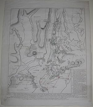
A Plan of New York Island, with part of Long Island, Staten Island & East New Jersey.
Published by London: William Faden, October 19th, 1776., 1776
A Plan of New York Island, with part of Long Island, Staten Island & East New Jersey, with a particular description of the Engagement on the Woody Heights of Long Island, between Flatbush and Brooklyn, on the 27th of August 1776. Between his majesty's forces commanded by General Howe and the Americans under Major General Putnam shewing also the Landing of the British Army on New-York Island, and the taking of the City of New-York & on the 15th of September following, with the Subsequent Disposition of Both the Armies Single sheet (sheet size: 23 x 19 inches; 18 4/8 x 16 4/8 inches to the neat line, full margins showing the plate mark). Fine engraved battle plan of New York and environs, the title and imprint below the neat line, showing New York from Staten Island in the south to Yonkers in the north, with "References to the Battle of Long Island" lower right, and troop deployments shown in contemporary red (the British) and green (the Americans) colour wash. State 4 (of 5 states), each subsequent state showing stages in the progress of the battle and updating features on the map. In this example Fort Washington is now marked, being lettered in the Hudson River near the head of New York Island. On the Jersey shore, opposite the head of N.Y. Island, Fort Independence is added. The British troops are shown surrounding the Americans holding the Heights of Guana from the 22nd to the 26th of August, followed by the American's retreat through Brooklyn to Kepp's Bay by the 15th of September, and to Morris's Heights and Fort Washington by the 26th. On the 3rd of September British Troops are at Bushwick and New Town, by the 15th they are at the base of New York Island and further north near Bloomingdale. The British navy is shown in the Hudson River, and throughout the East River. In anticipation of an attack by the British on New York George Washington, with five regiments of the army which had served him in New England, arrived there in early April of 1776. While the Continental Congress proclaimed the Declaration of Independence on July the 4th, Washington set about strengthening defenses, including building Fort Washington at the end of New York Island on the shore of the Hudson. With the reading of the new Declaration, on Washington's order, at the head of each brigade of the army in or near New York after it was adopted by the New York provincial congress on the 9th of July, and publically proclaimed from the City Hall in Wall Street on the 18th, New York came out firmly for the patriot cause. On the 27th of August the battle of Long Island occurred, "and as the British were greatly superior to their opponents in numbers, equipment, and training, they were everywhere victorious. By two o'clock in the afternoon they had taken the outer line of defense, and the Americans were driven within the fortified camp on Brooklyn Heights, where they were in grave danger of being captured" (Stokes, page 322). Being routed from Long Island, Washington crossed the river to Manhattan and held it, while he and Congress decided whether to burn the City behind them, or leave it to be occupied by the British troops over winter. On the 13th of September, with the evacuation of the City in progress, British ships sailed up the Hudson as far as Bloomingdale, cutting off the transportation of stores by water, and on the 15th landed at Kip's Bay cutting off the American rear-guard. All of this is clearly and faithfully recorded on Faden's map, and as such Faden's plan of the theatre of War in New York is one of the most important of the American Revolution. First published less than a month after the battle on October the 19th, 1776 the plan shows towns, settlements, roads, fortifications, topographical features in relief, as a background to the military positions and events of the battle. Nebenzahl, Atlas of the American Revolution, 12; Nebenzahl, Printed Battle Plans 107; Tooley p. 75, Stevens-Tree 41d; Stokes Iconography 1:353-55; cf. NYPL/Deak 153-55.
-
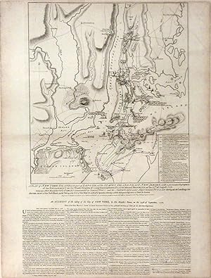
A Plan of New York Island, with part of Long Island, Staten Island & East New Jersey.
Published by London: William Faden, October 19th, 1776., 1776
A Plan of New York Island, with part of Long Island, Staten Island & East New Jersey, with a particular description of the Engagement on the Woody Heights of Long Island, between Flatbush and Brooklyn, on the 27th of August 1776. Between his majesty's forces commanded by General Howe and the Americans under Major General Putnam shewing also the Landing of the British Army on New-York Island, and the taking of the City of New-York & on the 15th of September following, with the Subsequent Disposition of Both the Armies Single sheet (sheet size: 30 2/8 x 21 4/8 inches; 18 4/8 x 16 4/8 inches to the neat line, full margins showing the plate mark; framed size: 42 4/8 x 33 inches). Fine engraved battle plan of New York and environs, the title and imprint below the neat line, showing New York from Staten Island in the south to "Fort" in the north, four columns of letterpress below the plate-mark, with "References to the Battle of Long Island" lower right, and troop deployments shown in hatched boxes (the British) and open boxes (the Americans), the waterways with delicate original hand colour. Fifth and last state, this issue on large paper with the four columns of text relating to the attack on Long Island beneath the plan titled: "An account of the Proceedings of HIs Majesty's Forces at the attack of the Rebels Works on Long Island, on the 27th August, 1776". Each subsequent state shows different stages in the progress of the battle and updates features on the map. In this example the text beneath has a new title and is entirely reset, the last line of the imprint reads "Mr. Wallis Bookseller in Ludgate Street", "Younker" at the top of the map has been deleted and the word "Fort" inserted, Fort Washington is now shown about three inches below the head of New York Island, adjacent to a point in the river now marked "Jefferys Hook", the lettering for Fort Washington is now marked on the island itself, Fort Lee or "Ft. Constitution" is now marked on the Jersey side a little south of a point opposite Jefferys Hook. The lettering marking "Fort Independence", etc has now been deleted, British troops are shown surrounding the Americans holding the Heights of Guana from the 22nd to the 26th of August, followed by the American's retreat through Brooklyn to Kepp's Bay by the 15th of September, and to Morris's Heights and Fort Washington. On the 3rd of September British Troops are at Bushwick and New Town, by the 15th they are at the base of New York Island and further north near Bloomingdale. The British navy is shown in the Hudson River, and throughout the East River. In anticipation of an attack by the British on New York George Washington, with five regiments of the army which had served him in New England, arrived there in early April of 1776. While the Continental Congress proclaimed the Declaration of Independence on July the 4th, Washington set about strengthening defenses, including building Fort Washington at the end of New York Island on the shore of the Hudson. With the reading of the new Declaration, on Washington's order, at the head of each brigade of the army in or near New York after it was adopted by the New York provincial congress on the 9th of July, and publically proclaimed from the City Hall in Wall Street on the 18th, New York came out firmly for the patriot cause. On the 27th of August the battle of Long Island occurred, "and as the British were greatly superior to their opponents in numbers, equipment, and training, they were everywhere victorious. By two o'clock in the afternoon they had taken the outer line of defense, and the Americans were driven within the fortified camp on Brooklyn Heights, where they were in grave danger of being captured" (Stokes, page 322). Being routed from Long Island, Washington crossed the river to Manhattan and held it, while he and Congress decided whether to burn the City behind them, or leave it to be occupied by the British troops over winter. On the 13th of September, with the evac.
-
The Province of New Jersey Divided into East and West, commonly called the Jerseys
Published by London, 1777
Seller: Arader Galleries of Philadelphia, PA, Philadelphia, PA, U.S.A.
Seller Rating:
Book
N/A. Condition: Very Good. William Faden (1749-1836) The Province of New Jersey Divided into East and West, commonly called the Jerseys Published, London, 1777 Engraving with original hand color Sheet size: 32 x 23 1/2 inches William Faden's monumental map of New Jersey was based on a survey made by Bernard Ratzer in 1769, for use in the settlement of a 100 year long dispute between New York and New Jersey. Faden's map was the first to show New Jersey's northern border with New York, and also depicts the area known to George Washington prior to the battle of Monmouth, and a fortified Valley Forge. The most important map of the area from the Revolutionary period, it was also the largest map of New Jersey that had ever been produced. Unprecedented in its detail and precision, Faden's map remained the standard geographic representation of the state until well into the 1800s. Faden's attention to the esthetic appeal of his map is also apparent. The fine beauty of engraving is emphasized by the cartouche in the upper-left corner, where a farmhouse can be seen between two graceful trees, and also by the ranges of hills delicately shaded as if illuminated from the northwest. Partner of Thomas Jefferys, London's leading mid-18th century engraver, William Faden assumed sole control of the business after his colleague's death and continued Jefferys's tradition of producing the finest quality engraved maps and atlases. Faden's fine engravings, in fact, made him one of the greatest cartographers of the 18th century. Faden's talent for mapmaking was such that he was named official geographer to the king in 1775, two years before he produced this map, a landmark in the cartography of New Jersey. The Province of New Jersey was included in Faden's North American Atlas, a large folio work that is the most rare and important cartographic record of the early years of the American Revolution. All of the maps contained in the atlas possessed a wealth of topographical detail based on information obtained by first-hand observation, a factor that makes them historical documents of great importance. Faden's map was much consulted during the Revolution, and represents the best state of knowledge regarding New Jersey in the 18th century.
-
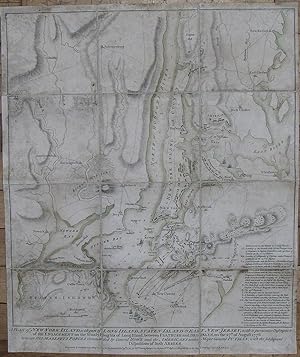
A Plan of New York Island, with part of Long Island, Staten Island & East New Jersey.
Published by London: William Faden, October 19th, 1776., 1776
A Plan of New York Island, with part of Long Island, Staten Island & East New Jersey, with a particular description of the Engagement on the Woody Heights of Long Island, between Flatbush and Brooklyn, on the 27th of August 1776. Between his majesty's forces commanded by General Howe and the Americans under Major General Putnam shewing also the Landing of the British Army on New-York Island, and the taking of the City of New-York & on the 15th of September following, with the Subsequent Disposition of Both the Armies Single sheet, float-mounted and framed (sheet size: 26 6/8 x 21 6/8 inches; 18 6/8 x 16 4/8 inches to the neat line, full margins showing the plate mark; framed size 39 x 32 inches). Fine engraved battle plan of New York and environs, the title and imprint below the neat line, four columns of letterpress below the plate-mark, showing New York from Staten Island in the south to Yonkers in the north, with "References to the Battle of Long Island" lower right, and troop deployments shown in contemporary red (the British) and green (the Americans) colour wash (recently and expertly restored at the top and bottom edge affecting the letterpress and the border, old horizontal crease). State 3 (of 5 states), this issue on large paper with the four columns of text relating to the attack on Long Island beneath the plan titled "An account of the taking of the City of New York, by His Majesty's forces, on the 15th of September, 1776. Taken from Gen. Howe's Letter to Lord George Germaine, Principal Secretary of State for the American Department". Each subsequent state of the plan shows stages in the progress of the battle and updates features on the map. In this example the the last line of the title now reads "British Army on New-York Island, and the taking of the City of New-York & on the 15th of September following, with the Subsequent Disposition of Both the Armies", Fort Washington does NOT appear, the Heights of Long Island are now lettered on the left as "The Heights of Guana" and on the right as "The Woody Heights of Guana", three lines of lettering have been added on the Jersey shore opposite the head of New York Island "Flying Camp / of the Americans / Redoubt with Cannon". The British troops are shown surrounding the Americans holding the Heights of Guana from the 22nd to the 26th of August, followed by the American's retreat through Brooklyn to Kepp's Bay by the 15th of September, and to Morris's Heights and Fort Washington by the 26th. On the 3rd of September British Troops are at Bushwick and New Town, by the 15th they are at the base of New York Island and further north near Bloomingdale. The British navy is shown in the Hudson River, and throughout the East River. In anticipation of an attack by the British on New York George Washington, with five regiments of the army which had served him in New England, arrived there in early April of 1776. While the Continental Congress proclaimed the Declaration of Independence on July the 4th, Washington set about strengthening defenses, including building Fort Washington at the end of New York Island on the shore of the Hudson. With the reading of the new Declaration, on Washington's order, at the head of each brigade of the army in or near New York after it was adopted by the New York provincial congress on the 9th of July, and publically proclaimed from the City Hall in Wall Street on the 18th, New York came out firmly for the patriot cause. On the 27th of August the battle of Long Island occurred, "and as the British were greatly superior to their opponents in numbers, equipment, and training, they were everywhere victorious. By two o'clock in the afternoon they had taken the outer line of defense, and the Americans were driven within the fortified camp on Brooklyn Heights, where they were in grave danger of being captured" (Stokes, page 322). Being routed from Long Island, Washington crossed the river to Manhattan and held it, while he and Congress decided whether to.
-
A Plan of New York Island, with part of Long Island, Staten Island & East New Jersey
Published by London: William Faden, October 19th, 1776., 1776
A Plan of New York Island, with part of Long Island, Staten Island & East New Jersey, with a particular description of the engagement on the Woody Heights of Long Island, between Flatbush and Brooklyn, on the 27th. of August 1776 between His Majesty's forces commanded by General Howe and the Americans under Major General Putnam, with the subsequent disposition of both armies. Folding engraved map (21 x 17 2/8 inches; 18 6/8 x 16 6/8 inches to the neat line), laid down on cartographic linen in 12 sections. Fine engraved battle plan of New York and environs, the title and imprint below the neat line, showing New York from Staten Island in the south to Tetard's Hill in the north, with original colour wash in outline, "References to the Battle of Long Island" lower right, and troop deployments shown in contemporary red (the British) and green (the Americans) colour wash. Provenance: with "Fort Jay" marked in manuscript on Governor's Island, first erected on the highest point of Governor's Island by Continental troops in 1775-1776. The island and its fort were occupied by the British during the American Revolution until 1783, when it was surrendered, along with several buildings, to the Governor of New York. First state (of 5 states), each subsequent state showing stages in the progress of the battle and updating features on the map. In this example the fourth line of the title reads "Disposition of both Armies", the sea coast, harbour and rivers are shown in single outline only, without any shading, the most northerly place marked on the Hudson River is 'Tetard's Hill", the Heights on Long Island are named twice as just "The Heights". The British troops are shown surrounding the Americans holding the Heights [of Guana] from the 22nd to the 26th of August, on the 3rd of September British Troops are at New Town. The British navy is shown in the Hudson River, and at Flushing in the East River. In anticipation of an attack by the British on New York George Washington, with five regiments of the army which had served him in New England, arrived there in early April of 1776. While the Continental Congress proclaimed the Declaration of Independence on July the 4th, Washington set about strengthening defenses, including building Fort Washington at the end of New York Island on the shore of the Hudson. With the reading of the new Declaration, on Washington's order, at the head of each brigade of the army in or near New York after it was adopted by the New York provincial congress on the 9th of July, and publically proclaimed from the City Hall in Wall Street on the 18th, New York came out firmly for the patriot cause. On the 27th of August the battle of Long Island occurred, "and as the British were greatly superior to their opponents in numbers, equipment, and training, they were everywhere victorious. By two o'clock in the afternoon they had taken the outer line of defense, and the Americans were driven within the fortified camp on Brooklyn Heights, where they were in grave danger of being captured" (Stokes, page 322). Being routed from Long Island, Washington crossed the river to Manhattan and held it, while he and Congress decided whether to burn the City behind them, or leave it to be occupied by the British troops over winter. All of this is clearly and faithfully recorded on Faden's map, and as such Faden's plan of the theatre of War in New York is one of the most important of the American Revolution. First published less than a month after the battle on October the 19th, 1776 the plan shows towns, settlements, roads, fortifications, and topographical features, as a background to the military positions and events in the early stages of the battle. Nebenzahl, Atlas of the American Revolution, 12; Nebenzahl, Printed Battle Plans 107; Tooley p. 75, Stevens-Tree 41a; Stokes Iconography 1:353-55; cf. NYPL/Deak 153-55.