
Order Total (1 Item Items):
Shipping Destination:

William Janszoon Blaeu (2 results)
Skip to main search results
Product Type
- All Product Types
- Books (1)
- Magazines & Periodicals
- Comics
- Sheet Music
- Art, Prints & Posters
- Photographs
- Maps (1)
-
Manuscripts &
Paper Collectibles
Condition
- All Conditions
- New
- Used
Binding
- All Bindings
- Hardcover
- Softcover
Collectible Attributes
- First Edition
- Signed
- Dust Jacket (1)
- Seller-Supplied Images (1)
- Not Printed On Demand
Seller Location
Seller Rating
-
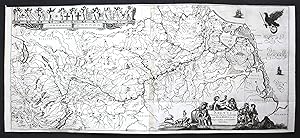
Rhenus Fluviorum Europae Celeberrimus, cum Mosa, Mosella, et reliquis, in illum se exonerantibus fluminibus" - Rheinlauf Rhein Rhine Bodensee Nordsee Deutschland Karte map carte
Published by ca. 1670., 1670
Seller: Antiquariat Steffen V�lkel GmbH, Seubersdorf, Germany
Seller Rating:

Map
Original Kupferstich-Karte des Rheinlaufes, vom Bodensee bis zur M�ndung -- von ca. 1670 - Blatt-Ma�e: ca. 92 x 41 cm - zwei Kupferplatten zusammengefasst -- mit einem hinterlegten Einriss; leicht gebr�unt, sonst gut erhalten. -- selten || original copper engraved map of the river Rhein, from Bodensee to the North Sea -- formed by two copper plates joined together -- dating from around 1670 - with one deposited tear, slightly brownstained, otherwise in good condition. -- rare || Dies ist ein Original! - Kein Nachdruck! - Keine Kopie! | This is an original! - No reprint! - No copy! la Gewicht in Gramm: 35.
-

America nova tabula
Published by Amsterdam, 1638
Seller: Arader Galleries of Philadelphia, PA, Philadelphia, PA, U.S.A.
Seller Rating:
Book
N/A. Condition: Very Good. Dust Jacket Condition: N/A. Engraving with original hand-color. Circa 1638. Sheet size: 17 1/2 x 22 7/8�. Frame size: 32 x 35 1/2". Inventory#: p1913pfat. 0.
