Order Total (1 Item Items):
Shipping Destination:

Young & Delleker (16 results)
Skip to main search results
Product Type
- All Product Types
- Books (16)
- Magazines & Periodicals
- Comics
- Sheet Music
- Art, Prints & Posters
- Photographs
- Maps
-
Manuscripts &
Paper Collectibles
Condition
- All Conditions
- New
- Used
Binding
- All Bindings
- Hardcover (7)
- Softcover
Collectible Attributes
- First Edition (2)
- Signed
- Dust Jacket (3)
- Seller-Supplied Images (12)
- Not Printed On Demand
Seller Location
Seller Rating
-
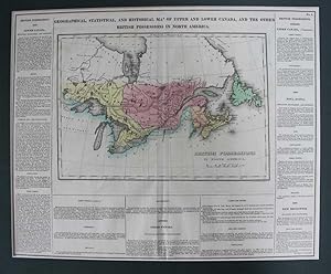
Geographical, Statistical, And Historical Map Of Upper And Lower Canada, And The Other British Possessions In North America. British Possessions In North America
Published by H.C. Carey & I. Lea, Philadelphia, 1823
Seller: Lord Durham Rare Books (IOBA), St. Catharines, ON, Canada
Association Member: IOBA
Seller Rating:

No binding. Condition: Very Good. Paper size 17.5 x 22 wide, text & image size 16-1/2 x 20-1/4 inches and actual map image size (map border) : 9-1/4 x 13-1/2 inches. Hand-colored map surrounded by statistical data, 'Geographical, Statistical and Historical Map of Upper and Lower Canada, and the Other British Possessions in North America.' Originally issued as folded now flat with the fold slightly covering the p in map and the s in possessions in the top heading. Small gray mark in in border next to "commerce" text on bottom left. Overall condition is very good other than noted above. Map and references for the British Empire in Canada, from Carey and Lea's 'A Complete Historical, Chronological, and Geographical American Atlas. The map extends from Newfoundland in the east to Lake of the Woods in the west; a very vibrant, strong impression. The text describes Lower Canada, Upper Canada, Nova Scotia and New Brunswick. With text below map and at both sides, pertaining to topography, climate, lands, towns, roads and canals, education, government and history.
-
![Seller image for [Map] Canada, by A. Finley, 1830 for sale by Kaaterskill Books, ABAA/ILAB](https://pictures.abebooks.com/inventory/md/md30722367794.jpg)
[Map] Canada, by A. Finley, 1830
Published by A. Finley, Philadelphia, 1830
Seller: Kaaterskill Books, ABAA/ILAB, East Jewett, NY, U.S.A.
Association Member: ABAA ILAB IOBA
Seller Rating:
First Edition
1 sheet. 22 x 29 cm on 27 x 35 cm sheet. Cooper engraved colored map. 8.5 x 11.25 inches. Engraving by Young & Delleker. Taken from 'A New General Atlas'. Engraving by Young & Delleker. Includes Upper and Lower Canada, New Brunswick, and Nova Scotia. According to Ramsey "This atlas was first issued in 1824, with editions published annually to 1834. Each succeeding year new maps were added and others updated." The map of Canada in this edition added material not found in the first edition and does not have color added just to the right of Lake Superior. Phillips: Atlases 755-5. Very good, minor edge wear and soiling.
-
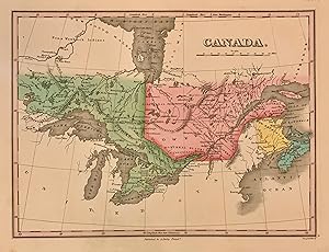
Canada
Published by Anthony Finley, Philadelphia, 1824
Seller: Argosy Book Store, ABAA, ILAB, New York, NY, U.S.A.
Seller Rating:
hardcover. Young & Delleker (illustrator). Map. Engraving with original hand coloring. Image measures 9" x 11 1/2" Beautiful early map of Canada, then known as Upper Canad and Lower Canada, Extending to Winnipeg River. Toronto is still named York, Roads, waterways, islands, geographical features are labeled. Great lakes are all labelled. Extensive notes on Indigenous regions are noted. In very good condition, with extra care taken with the original coloring. Anthony Finley (c. 1790-1840) was a prominent American cartographic publisher in the early 19th century. He is best known for his "New General Atlas", and "New American Atlas", which were well received and praised for their clearness and accuracy.
-
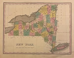
New York
Published by Anthony Finley, Philadelphia, 1824
Seller: Argosy Book Store, ABAA, ILAB, New York, NY, U.S.A.
Seller Rating:
hardcover. Young & Delleker (illustrator). Map. Engraving with original hand coloring. Image measures 8 1/2" x 11 1/4" Early map of New York state divided into counties. Cities, towns, roads, waterways, islands, geographical features are labeled. In very good condition, with some very minimal spotting, and minor wear to margins not affecting the image. Otherwise clean and bright with extra care taken with the original coloring. Anthony Finley (c. 1790-1840) was a prominent American cartographic publisher in the early 19th century. This map was published in "A New General Atlas", which was well received and praised for its clearness and accuracy.
-
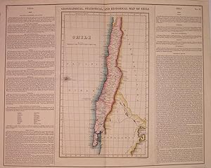
Geographical, Historical, and Statistical Map of Chili
Published by Carey & Lea, Philadelphia, 1823
Seller: Argosy Book Store, ABAA, ILAB, New York, NY, U.S.A.
Seller Rating:
unbound. Condition: very good. Young & Delleker (illustrator). Map. Engraving with original hand coloring. Image measures 15" x 9", image plus text measure 16.75" x 20.5". Beautiful map of Chili from 1823. Includes information pertaining to history, climate and culture. From "A Complete Historical, Chronological, and Geographical American Atlas." of 1822. Run by Henry Carey (1793-1879) and Isaac Lea (1792-1886), the company worked with both books and maps, specializing particularly in political commentary. Their "Complete Historical, Chronological, and Geographical American Atlas," first published in 1822, not only contained some of the earliest maps of western states being admitted to the Union, it also provided ample information on each state and country providing an invaluable window into the nation's history.
-

No Binding. Condition: Near Fine. Young and Delleker (illustrator). Hand-coloring of each of the 7 counties, as well as the map's border done in Pink. County colors; Red, Orange, Blue, Green, Yellow. A pressed lithographic map with nice relief margins. Total area: 13.75" x 10.75", Map area: 11.25" x 8.5". A Colorful & Fine example of Finley's 1827 map of New Hampshire depicting the state with moderate detail as was Finley's classic minimalist style. Shows riverways, roads, canals, and other topographical features. Title and scale in the upper right quadrant. It is very uncommon to find an early 19th century exclusively depicting New Hampshire, as most maps of the period bundled it with Vermont. Identifies Grand Monadnock Mn., Moosehillock Mn., and Mount Washington. Moosehead lake (Maine) is shown listed by it's earlier title: "Moosetocmaguntic Lake". Engraved by Young and Delleker for the 1827 edition of Anthony Finley's General Atlas. Book.
-
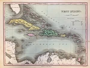
West Indies
Published by Anthony Finley, Philadelphia, 1824
Seller: Argosy Book Store, ABAA, ILAB, New York, NY, U.S.A.
Seller Rating:
unbound. Young & Delleker (illustrator). Map. Engraving with original hand coloring. Image measures 8.5" x 11.25". This lovely 1824 map by Anthony Finley features the West Indies and Caribbean Islands. Extends from southern Florida to northern South America and includes the Bahamas, the Leeward and Windward Islands. Cat Isle in the Bahamas is noted as 'the first land seen by Columbus, 1492'. The map is beautifully detailed and notes the important cities and some topographic features. The map is in good condition with minor toning and foxing. Original plate mark is visible. Lower margin shows tear, not affecting printed image. Anthony Finley (c. 1790-1840) was a prominent American cartographic publisher in the early 19th century. This map was published in "A New General Atlas", which was well received and praised for its clearness and accuracy. Concise coloring matches the index of Colonial activity.
-
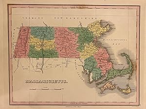
Massachusetts
Published by Anthony Finley, Philadelphia, 1827
Seller: Argosy Book Store, ABAA, ILAB, New York, NY, U.S.A.
Seller Rating:
hardcover. Young & Delleker (illustrator). Map. Engraving with original hand coloring. Image measures 9" x 11 1/2" Classic map of Massachusetts divided into counties. Cities, towns, roads, waterways, islands, geographical features are labeled. In very good condition, with some foxing in the coastal area off of Cape Cod. Otherwise clean and bright with extra care taken with the original coloring. Anthony Finley (c. 1790-1840) was a prominent American cartographic publisher in the early 19th century. He is best known for his "New General Atlas", and "New American Atlas", which were well received and praised for their clearness and accuracy.
-
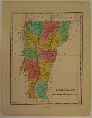
Vermont
Published by Anthony Finley, Philadelphia, 1829
Seller: Argosy Book Store, ABAA, ILAB, New York, NY, U.S.A.
Seller Rating:
hardcover. Condition: very good(+). Young & Delleker (illustrator). Map. Engraving with original hand coloring. Image measures 11 1/8" x 8 5/8". Beautiful map of Vermont divided into counties. Shows place names, major routes, topographical details and waterways. Small chip to lower left corner. Light stain to right margin. Anthony Finley (c. 1790-1840) was a prominent American cartographic publisher in the early 19th century. This map was published in "A New General Atlas", which was well received and praised for its clearness and accuracy.
-
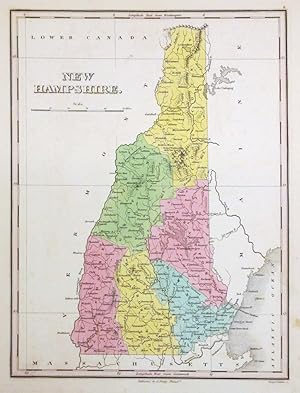
New Hampshire
Published by Anthony Finley, Philadelphia, 1824
Seller: Argosy Book Store, ABAA, ILAB, New York, NY, U.S.A.
Seller Rating:
unbound. Young & Delleker (illustrator). Map. Engraving with original hand coloring. Image measures 11 1/8" x 8 5/8". Beautiful map of New Hampshire divided into counties. Shows place names, major routes, topographical details and waterways. In maps from this period, New Hampshire was usually bundled together with Vermont. This is an uncommon map exclusively depicting New Hampshire. In very good condition. Minor foxing. Anthony Finley (c. 1790-1840) was a prominent American cartographic publisher in the early 19th century. This map was published in "A New General Atlas", which was well received and praised for its clearness and accuracy.
-

Rhode Island
Published by Anthony Finley, Philadelphia, 1824
Seller: Argosy Book Store, ABAA, ILAB, New York, NY, U.S.A.
Seller Rating:
hardcover. Young & Delleker (illustrator). Map. Engraving with original hand coloring. Image measures 11 3/8" x 8 5/8" Lovely map of Rhode Island divided into counties. Cities, towns, roads, waterways, islands, geographical features are labeled. Notably, some points of interest are also included, such as a ship yard, iron works, bridges, and mills. These sites illustrate the growing industries of the state in the early 19th century. Topography is depicted by hachure. In excellent condition. Anthony Finley (c. 1790-1840) was a prominent American cartographic publisher in the early 19th century. This map was published in "A New General Atlas", which was well received and praised for its clearness and accuracy. A must-have in any map collection.
-
Geographical, Statisical, and Historical Map of the District of Columbia
Published by Carey & Lea, Philadelphia, 1827
Seller: Arader Galleries of Philadelphia, PA, Philadelphia, PA, U.S.A.
Seller Rating:
Book
N/A. Condition: Very Good. Dust Jacket Condition: N/A. Engraving with original hand-coloring. From A Complete Historical, Chronological and Geographical American Atlas. Engraved by Young & Delleker. Sheet size: 17 5/8 x 21 3/4". Inventory#: p1119pmat.
-
Geographical, Statistical, and Historical Map of Michigan Territory.
Published by Carey & Lea, Philadelphia, 1822
Seller: Arader Galleries of Philadelphia, PA, Philadelphia, PA, U.S.A.
Seller Rating:
Book
N/A. Condition: Very Good. Dust Jacket Condition: N/A. Copperplate engaving with original hand-coloring, slight browning to left side of map, but otherwise a strong example of this visually dramatic first printed separate map of Michigan. From A Complete Historical, Chronological, and Geographical American Atlas. Plate No. 36. Drawn by J. Finlayson. Engrav'd by Young & Delleker. Sheet size: 17 3/4 x 22". Inventory#: p798pmat.
-
A New General Atlas, Comprising a Complete Set of Maps, Representing the Grand Divisions of the Globe, Together with the several Empires, Kingdoms, and States in the World; Compiled from the Best Authorities and Corrected by the Most Recent Discoveries.
Published by Anthony Finley, Philadelphia, 1831
Book
Hardcover. Condition: Poor. Jos. Perkins; Young and Delleker (illustrator). Folio. Ff. [63].The title is marked "Engraved by Jos. Perkins." Maps are marked "Young & Delleker sc[ulpserunt]." Contains engraved title, Index, General Statistical Table, and 59 out of the original 62 engraved, hand-colored maps of continents, countries, and states. Rhode Island (no. 11) New Jersey (no. 14) and Virgina (no. 18) are missing. Maryland (no. 17) and North Carolina (no. 19) are detached but present. The last two leaves are a chart of the length of rivers, and a chart of the heights of mountains, both also hand-colored. The maps are fine except for occasional light foxing to margins, and a small burn mark to the top edge of the text block. Covers, half leather, detached. Spine dry and alligatored. Two maps each represent "Turkey in Europe" and "Turkey in Asia." Russia is the same. The only African country is Liberia.
-
Geographical, Statistical, and Historical Map of Mexico
Published by Carey & Lea, Philadelphia, 1822
Seller: Arader Galleries of Philadelphia, PA, Philadelphia, PA, U.S.A.
Seller Rating:
Book
N/A. Condition: Very Good. Dust Jacket Condition: N/A. Engraving with original hand-color. From Complete Historical, Chronological and Geographical American Atlas. No. 38. Prepared from Humboldt's Map and other Documents by J. Finlayson. Engraved by Young & Delleker. Sheet size: 17 1/2 x 21 3/4". Inventory#: p1390pmat.
-
A New General Atlas, Comprising a Complete Set of Maps, representing the Grand Divisions of the Globe, Together with the several Empires, Kingdoms and States in the World. Compiled from the Best Authorities and corrected by the Most Recent Discoveries, Philadelphia
Published by Anthony Finley, Philadelphia, 1824
Seller: Argosy Book Store, ABAA, ILAB, New York, NY, U.S.A.
Seller Rating:
First Edition
hardcover. Condition: very good. Young & Delleker (illustrator). First. Atlas. Illustrated with 58 hand colored engraved maps and 2 charts. Small folio (13.5" x 10.75"); publisher's half leather and marbled boards; spine is gilded in 6 compartments, faded; original printed green paper label on cover. Second issue of first edition. All engravings by Young & Delleker. Some wear to edges, minor dampstaining to endpaper and title page. Minor scattered foxing in margins, images mostly unaffected. Severe foxing to map of South America. Owner signature in pen on title page (John L. Brune ?). Philadelphia: Anthony Finley, 1824. Anthony Finley (c. 1790-1840) was a prominent American cartographic publisher in the early 19th century. "A New General Atlas" was well received and praised for its clearness and accuracy. Plates in this edition include 27 maps of North America (including Georgia, New England states, New York and Mexico), 17 of Europe and 8 of Asia, Africa and South America. Western and Eastern Hemispheres are also included, plus the world on the Mercator Projection. The 2 charts are comparative of mountains and rivers around the world.