Order Total (1 Item Items):
Shipping Destination:

Burlington Llewellyn Murray (3 results)
Skip to main search results
Product Type
- All Product Types
- Books (3)
- Magazines & Periodicals
- Comics
- Sheet Music
- Art, Prints & Posters
- Photographs
- Maps
- Manuscripts & Paper Collectibles
Condition
Binding
- All Bindings
- Hardcover (2)
- Softcover
Collectible Attributes
- First Edition (2)
- Signed
- Dust Jacket
- Seller-Supplied Images (2)
- Not Print on Demand (3)
Free Shipping
- Free US Shipping
Seller Location
Seller Rating
-

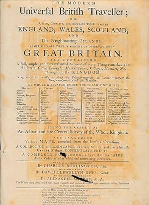
The New British Traveller; or, A Complete Modern Universal Display of Great Britain and Ireland: Being a New, Complete, Accurate and Extensive Tour Through England, Wales, Scotland, Ireland, The Isles of Man, Wight, Scilly, Hebrides, Jersey, Sark, Guernsey, Alderney, and Other Islands Adjoining to and Dependant on the Crown of Great Britain
Published by Printed for J Cooper, 1779, 1779
836pp, small folio, plus 105 full-page engravings, correct and present as called for, this had been double checked twice, 2 maps of the UK, one large folding and contempory hand-coloured, original old calf, a very good copy, good tight stitching, rare to.
-
The Modern Universal British Traveller; or, a New, Complete, and Accurate Tour through England, Wales, Scotland and the Neighbouring Islands. Comprising All that is Worthy of Observation in Great Britain. .
Published by J Cooke, London, 1782
First Edition
Brown hardback leather cover. First Edition. 360mm x 230mm (14" x 9"). 836pp + plates, maps & index. 83 (of 106) b/w plates + 2 fold-out maps. . And Containing a Full, Ample, and Circumstatial Account of Every Thing Remarkable in the Several Cities, Boroughs, Market Towns, Villages, Hamlets, &c., Throughout the Kingdom. . Being the Result of an Actual and Late General Survey . Including Various Maps, Corrected from the Latest Observations . a Collection of Landscapes, Views, &c., . Copper-Plate Prints. A Complete Road-Book; a List of all the Fairs, and a Variety of Other Useful and Entertaining Particulars. Often erroneously stated as published in 1779, but the main map is dated 1782. Heavy item - shipping supplement may apply for overseas. Worn condition. Boards detatched. Text block split. Several pages detached with edge-wear. 23 plates missing. Some foxing, but content in overall good condition.
-
The modern universal British traveller; or, a new, complete, and accurate tour through England, Wales, Scotland, and the neighbouring islands. Comprising all that is worthy of observation in Great Britain.
Published by J. Cooke, London: No. 17, at Shakespeare's Head, Pater-noster Row, 1779
Seller: Madoc Books (ABA-ILAB), Llandudno, CONWY, United Kingdom
Association Member: ABA ILAB IOBA PBFA
Seller Rating:

Book First Edition
Hardcover. Condition: Very Good. 1st Edition. VG+, 1779, First edition complete with plates & subscribers list, in quarter calf over green marbled boards. Spine, raised bands, blind tooling, gilt titles to red calf label. Internally, frontis, [3], (iv-vi), [1], 8-836 pp, [15] index, [1] pl list, [4] subscribers list, one fold-out map of Great Britain, one fold-out map of roads, 113 copper plates, 155 tables of road distances to London from each town by County, days and dates and places of fairs in each county and items sold, ink dedication to tp head (1891). Also includes mileage and boundaries of each county, population, parishes, etc., and number of parliamentary members for each. An amazing compendium of history and information organised by county under "general", "natural", "local", "biographical" and "miscellaneous", by county. Scotland and Wales are also included in this remarkable compendium. (352*223 mm). (ESTC T1100110). In all respects an excellent copy.