
Order Total (1 Item Items):
Shipping Destination:

Depot General Marine (45 results)
Skip to main search results
Product Type
- All Product Types
- Books (7)
- Magazines & Periodicals
- Comics
- Sheet Music
- Art, Prints & Posters (24)
- Photographs
- Maps (14)
-
Manuscripts &
Paper Collectibles
Condition
- All Conditions
- New
- Used
Binding
- All Bindings
- Hardcover (2)
- Softcover
Collectible Attributes
- First Edition (1)
- Signed
- Dust Jacket
- Seller-Supplied Images (40)
- Not Printed On Demand
Free Shipping
Seller Location
Seller Rating
-
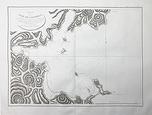
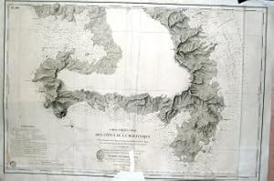
Plan de la Baie de Castries situee sur la cote orientale de Tartarie." - De-Kastri Ulchsky Khabarovsk Siberia Sibirien / Russia Russland Russie
Published by Paris ca. 1798., 1798
Seller: Antiquariat Steffen V�lkel GmbH, Seubersdorf, Germany
Seller Rating:

Map
Gro�formatige Kupferstich-Karte aus dem 18. Jh. -- Bildmasse: ca. 50 x 69 cm. -- gut erhalten. || Large copper engraved map from the 18th century. -- in good condition. Sprache: Franz�sisch Gewicht in Gramm: 35.
-

Condition: Fair. Carte lev�e en 1838 par les ing�nierus Hydrographes de la Marine sous les ordres de M,Beautemps-Beaupr�, Ingenieur Hydrographe en Chef. D�pot G�n�ral de la Marine. Paris 1842. Corrige from 1944 to 1972.
-
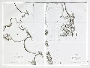
Port de Cou-Mong, situe par le travers de l'Ile Cambir" - Vietnam / Asia Asien Asie
Published by Paris ca. 1790., 1790
Seller: Antiquariat Steffen V�lkel GmbH, Seubersdorf, Germany
Seller Rating:
Map
Kupferstich-Karte aus dem 18. Jh. -- Bildmasse: ca. 44 x 61 cm. -- gut erhalten. || Copper engraved map from the 18th century. -- in good condition. Sprache: Franz�sisch Gewicht in Gramm: 35.
-
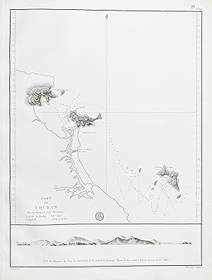
Port de Touran / Vue de l'entree du Port de Touran le Pic Sud de la Peninsule Thien-Tcha restant a O 1/4 NO, distance de Dix Milles" - Vietnam Da Nang / Asia Asien Asie
Published by Paris ca. 1790., 1790
Seller: Antiquariat Steffen V�lkel GmbH, Seubersdorf, Germany
Seller Rating:
Map
Kupferstich-Karte aus dem 18. Jh. -- Bildmasse: ca. 44 x 61 cm. -- gut erhalten. || Copper engraved map from the 18th century. -- in good condition. Sprache: Franz�sisch Gewicht in Gramm: 35.
-
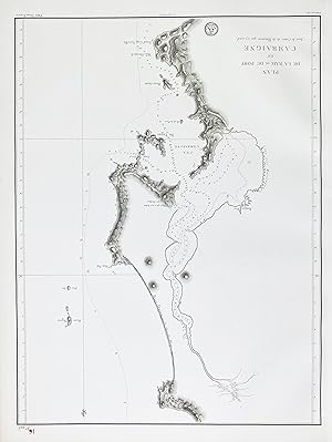
Plan de la Baie et du Port de Camraigne avec le Cours de la Riviere qui s'y rend" - Vietnam Baie de Cam Ranh / Asia Asien Asie
Published by Paris ca. 1790., 1790
Seller: Antiquariat Steffen V�lkel GmbH, Seubersdorf, Germany
Seller Rating:
Map
Gro�formatige Kupferstich-Karte. -- Bildmasse: ca. 60 x 44 cm. -- gut erhalten. || Large format engraved map. -- in good condition. Sprache: Franz�sisch Gewicht in Gramm: 35.
-
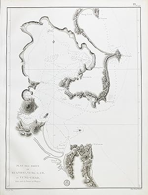
Plan de Ports de Xuandai, Vung-Lam, et Vung-Chao, situes dans la Province de Phuyen." - Vietnam Xuan Dai / Asia Asien Asie
Published by Paris ca. 1790., 1790
Seller: Antiquariat Steffen V�lkel GmbH, Seubersdorf, Germany
Seller Rating:
Map
Kupferstich-Karte aus dem 18. Jh. -- Bildmasse: ca. 60 x 44 cm. -- gut erhalten. || Copper engraved map from the 18th century. -- in good condition. Sprache: Franz�sisch Gewicht in Gramm: 35.
-
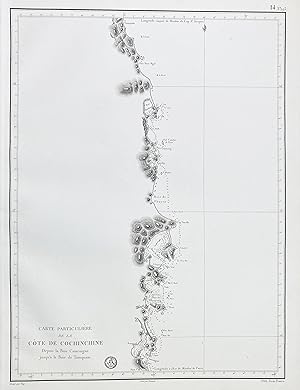
Carte particuliere de la Cote de Cochinchine depuis la Baie Camraigne jusqu'a la Baie de Tamquam" - Vietnam / Asia Asien Asie
Published by Paris ca. 1790., 1790
Seller: Antiquariat Steffen V�lkel GmbH, Seubersdorf, Germany
Seller Rating:
Map
Gro�formatige Kupferstich-Karte. -- Bildmasse: ca. 61 x 44 cm. -- gut erhalten. || Large format engraved map. -- in good condition. Sprache: Franz�sisch Gewicht in Gramm: 35.
-
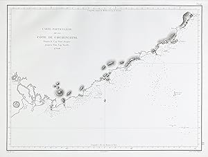
Carte particuliere de la Cote de Cochinchine depuis le Cap Saint Jacques jusqu'au Faux Cap Varelle" - Vietnam / Asia Asien Asie
Published by Paris ca. 1790., 1790
Seller: Antiquariat Steffen V�lkel GmbH, Seubersdorf, Germany
Seller Rating:
Map
Gro�formatige Kupferstich-Karte. -- Bildmasse: ca. 44 x 61 cm. -- gut erhalten. || Large format engraved map. -- in good condition. Sprache: Franz�sisch Gewicht in Gramm: 35.
-

Plan de la Cote de Cochinchine depuis l'Ile Shala, jusqu'au Cap Varelle avec les parts de Hone-Cohe et de Coua-Bay" - Vietnam / Asia Asien Asie
Published by Paris ca. 1790., 1790
Seller: Antiquariat Steffen V�lkel GmbH, Seubersdorf, Germany
Seller Rating:
Map
Gro�formatige Kupferstich-Karte. -- Bildmasse: ca. 60 x 44 cm. -- gut erhalten. || Large format engraved map. -- in good condition. Sprache: Franz�sisch Gewicht in Gramm: 35.
-

Carte des cotes de l'Amerique et de l'Asie depuis la Californie jusqu'a Macao" - North Pacific Ocean America Asia Japan Sandwich Islands Alaska California
Published by Paris, 1797
Seller: Antiquariat Steffen V�lkel GmbH, Seubersdorf, Germany
Seller Rating:
Map
Gro�formatige Kupferstich-Karte aus dem 18. Jh. -- Bildmasse: ca. 51 x 69 cm. -- gut erhalten. || Large copper engraved map from the 18th century. -- in good condition. || This expansive map illustrates the scope of La Perouse's expedition across the North Pacific. It encompasses the western shoreline of America, stretching from the Gulf of California to Alaska, as well as the eastern coast of Asia, from Tartary to Canton, incorporating regions like Formosa, Japan, and the Sandwich Islands (Hawaii). Additionally, it delineates the routes taken by La Boussole and L'Astrolabe. Sprache: Franz�sisch Gewicht in Gramm: 35.
-
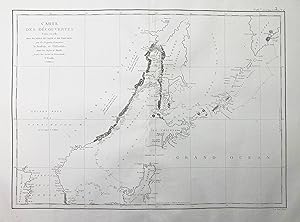
Carte des decouvertes faites en 1787 dans les mers de Chine et de Tartarie" - Japan Tartary / Asia Asien Asie
Published by Paris ca. 1798., 1798
Seller: Antiquariat Steffen V�lkel GmbH, Seubersdorf, Germany
Seller Rating:
Map
Gro�formatige Kupferstich-Karte aus dem 18. Jh. -- Bildmasse: ca. 51 x 69 cm. -- gut erhalten. || Large copper engraved map from the 18th century. -- in good condition. Sprache: Franz�sisch Gewicht in Gramm: 35.
-
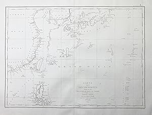
Carte des decouverts faites en 1787 dans les Mers de Chine et de Tartarie." - Japan Korea Taiwan China Philippines / Asia Asien Asie
Published by Paris ca. 1798., 1798
Seller: Antiquariat Steffen V�lkel GmbH, Seubersdorf, Germany
Seller Rating:
Map
Gro�formatige Kupferstich-Karte aus dem 18. Jh. -- Bildmasse: ca. 51 x 69 cm. -- gut erhalten. || Large copper engraved map from the 18th century. -- in good condition. Sprache: Franz�sisch Gewicht in Gramm: 35.
-
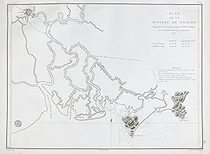
Plan de la Riviere de Saigon" - Vietnam Saigon Ho-Chi-Minh City river Indochina / Asia Asien Asie
Published by Paris, 1791
Seller: Antiquariat Steffen V�lkel GmbH, Seubersdorf, Germany
Seller Rating:
Map
Gro�formatige original Kupferstich-Karte. -- Bildmasse: ca. 44 x 60 cm. -- gut erhalten. || Large format original engraved map. -- in good condition. Sprache: Franz�sisch Gewicht in Gramm: 35.
-
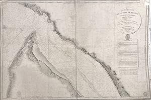
Carte Particuli�re des C�tes de France (Int�rieur de la Gironde, Premi�re Feuille) Lev�e en 1825
Published by Paris, 1831
Art / Print / Poster
Condition: ACEPTABLE. Carta n�uticarepresentando parte de las costas francesas, editado por el D�p�t G�n�ral de la Marine en 1831. [Grav� par E. Collins fils.] ; [Ecrit par Hacq.] . Formato (cm): 66x97.
-
![Seller image for Carte des C�tes Meridionales de France partie comprise entre Marseille et St. Tropez [Marsella y Saint Tropez] for sale by Frame](https://pictures.abebooks.com/inventory/md/md31138918208.jpg)
Carte des C�tes Meridionales de France partie comprise entre Marseille et St. Tropez [Marsella y Saint Tropez]
Published by Paris, 1868
Art / Print / Poster
Condition: ACEPTABLE. Carta n�uticarepresentando parte de las costas francesas, editado por el D�p�t G�n�ral de la Marine en 1831. [Grav� par E. Collins fils.] ; [Ecrit par Hacq.] . Formato (cm): 70x103.
-
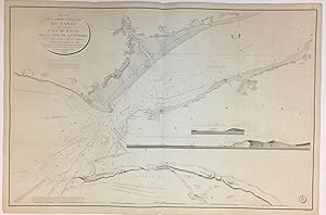
Plan de la Partie Occidentale Du Canal qui separe l'Ile de Wight, de la Cote de Hampshire
Published by Depot-general de la Marine, 1824
Seller: Argosy Book Store, ABAA, ILAB, New York, NY, U.S.A.
Seller Rating:
Sea Chart. Engraving. 24 3/4" x 37". Beautiful accurate and detailed sea chart depicting the strait that separates the Isle of Wight from the southern coast of England. The strait is now known as the Solent. Chips to margin and toning. The Isle of Wight is a county and the largest and second-most populous island in England. It is in the English Channel, about 2 miles (3.2 km) off the coast of Hampshire, separated by the Solent. During the Seven Years' War, the island was used as a staging post for British troops departing on expeditions against the French coast, such as the Raid on Rochefort. Official French maps were generated for military use.
-
Condition: ACEPTABLE. Oc�an Atlantique/ Iles �parses / Ile Sainte-H�l�ne / Lev�e en 1816 / Par lIng�nieur Anglais John Barnes / D�p�t-G�n�ral de la Marine / 1851 / Les Sondes sont exprim�es en m�tres. [Grav� par Chassant] ; [Ecrit par J.M. Hacq et V.Carr�] ; [PRIX.oF_50c] ; [N�. 1338] . Formato (cm): 25x32.
-
Condition: ACEPTABLE. Oc�an Atlantique / Iles �parses / Iles Bermudas / dapr�s les travaux les plus r�cents / D�p�t-G�n�ral de la Marine / 1852. [Grav� par Chassant _ Ecrit par J.M. Hacq et V.Carr�] ; [PRIX.of._75c.] ; [N�.1326] . Formato (cm): 48x32.
-
![Seller image for Oc�an Atlantique - Iles �parses - Santa Mar�a (Iles A�ores) [Islas Azores] for sale by Frame](https://pictures.abebooks.com/inventory/md/md31082518717.jpg)
Oc�an Atlantique - Iles �parses - Santa Mar�a (Iles A�ores) [Islas Azores]
Published by Paris, 1851
Art / Print / Poster
Condition: ACEPTABLE. Oc�an Atlantique/ Iles �parses / Ile Sainte-H�l�ne / Lev�e en 1816 / Par lIng�nieur Anglais John Barnes / D�p�t-G�n�ral de la Marine / 1851 / Les Sondes sont exprim�es en m�tres. [Grav� par Chassant] ; [Ecrit par J.M. Hacq et V.Carr�] ; [PRIX.oF_50c] ; [N�. 1338] . Formato (cm): 26x33'5.
-
![Seller image for Oc�an Atlantique - Iles �parses - Terceira (Iles A�ores) [Islas Azores] for sale by Frame](https://pictures.abebooks.com/inventory/md/md31082525547.jpg)
Oc�an Atlantique - Iles �parses - Terceira (Iles A�ores) [Islas Azores]
Published by Paris, 1851
Art / Print / Poster
Condition: ACEPTABLE. Oc�an Atlantique/ Iles �parses / Ile Sainte-H�l�ne / Lev�e en 1816 / Par lIng�nieur Anglais John Barnes / D�p�t-G�n�ral de la Marine / 1851 / Les Sondes sont exprim�es en m�tres. [Grav� par Chassant] ; [Ecrit par J.M. Hacq et V.Carr�] ; [PRIX.oF_50c] ; [N�. 1338] . Formato (cm): 26x33'5.
-
![Seller image for Oc�an Atlantique - Iles �parses - Graciosa (Iles A�ores) [Islas Azores] for sale by Frame](https://pictures.abebooks.com/inventory/md/md31082525550.jpg)
Oc�an Atlantique - Iles �parses - Graciosa (Iles A�ores) [Islas Azores]
Published by Paris, 1851
Art / Print / Poster
Condition: ACEPTABLE. Oc�an Atlantique/ Iles �parses / Ile Sainte-H�l�ne / Lev�e en 1816 / Par lIng�nieur Anglais John Barnes / D�p�t-G�n�ral de la Marine / 1851 / Les Sondes sont exprim�es en m�tres. [Grav� par Chassant] ; [Ecrit par J.M. Hacq et V.Carr�] ; [PRIX.oF_50c] ; [N�. 1338] . Formato (cm): 26x33'5.
-
![Seller image for Oc�an Atlantique - Iles �parses - Mayo, Santiago, Fogo, Brava (Iles de Cap Vert) [Islas de Cabo Verde] for sale by Frame](https://pictures.abebooks.com/inventory/md/md31082518716.jpg)
Oc�an Atlantique - Iles �parses - Mayo, Santiago, Fogo, Brava (Iles de Cap Vert) [Islas de Cabo Verde]
Published by Paris, 1851
Art / Print / Poster
Condition: ACEPTABLE. Oc�an Atlantique/ Iles �parses / Ile Sainte-H�l�ne / Lev�e en 1816 / Par lIng�nieur Anglais John Barnes / D�p�t-G�n�ral de la Marine / 1851 / Les Sondes sont exprim�es en m�tres. [Grav� par Chassant] ; [Ecrit par J.M. Hacq et V.Carr�] ; [PRIX.oF_50c] ; [N�. 1338] . Formato (cm): 33'5x50'5.
-
![Seller image for Oc�an Atlantique - Iles �parses - Mad�re, Porto Santo et Desertas [Madeira] for sale by Frame](https://pictures.abebooks.com/inventory/md/md31082525549.jpg)
Oc�an Atlantique - Iles �parses - Mad�re, Porto Santo et Desertas [Madeira]
Published by Paris, 1851
Art / Print / Poster
Condition: ACEPTABLE. Oc�an Atlantique/ Iles �parses / Ile Sainte-H�l�ne / Lev�e en 1816 / Par lIng�nieur Anglais John Barnes / D�p�t-G�n�ral de la Marine / 1851 / Les Sondes sont exprim�es en m�tres. [Grav� par Chassant] ; [Ecrit par J.M. Hacq et V.Carr�] ; [PRIX.oF_50c] ; [N�. 1338] . Formato (cm): 33'5x50'5.
-
![Seller image for Oc�an Atlantique - Iles �parses - Fayal, Pico et San Jorge (Iles A�ores) [Islas Azores] for sale by Frame](https://pictures.abebooks.com/inventory/md/md31082530334.jpg)
Oc�an Atlantique - Iles �parses - Fayal, Pico et San Jorge (Iles A�ores) [Islas Azores]
Published by Paris, 1851
Art / Print / Poster
Condition: ACEPTABLE. Oc�an Atlantique/ Iles �parses / Ile Sainte-H�l�ne / Lev�e en 1816 / Par lIng�nieur Anglais John Barnes / D�p�t-G�n�ral de la Marine / 1851 / Les Sondes sont exprim�es en m�tres. [Grav� par Chassant] ; [Ecrit par J.M. Hacq et V.Carr�] ; [PRIX.oF_50c] ; [N�. 1338] . Formato (cm): 33'5x50'5.
-
![Seller image for Oc�an Atlantique - Iles �parses - Iles du Cap Vert [Cabo Verde] for sale by Frame](https://pictures.abebooks.com/inventory/md/md31082530335.jpg)
Oc�an Atlantique - Iles �parses - Iles du Cap Vert [Cabo Verde]
Published by 185?, Paris
Art / Print / Poster
Condition: ACEPTABLE. Oc�an Atlantique/ Iles �parses / Ile Sainte-H�l�ne / Lev�e en 1816 / Par lIng�nieur Anglais John Barnes / D�p�t-G�n�ral de la Marine / 1851 / Les Sondes sont exprim�es en m�tres. [Grav� par Chassant] ; [Ecrit par J.M. Hacq et V.Carr�] ; [PRIX.oF_50c] ; [N�. 1338] . Formato (cm): 33'5x50'5.
-
![Seller image for Oc�an Atlantique - Iles �parses - Sn. Antonio, Sn. Vicente, Sta. Luc�a, Branco, Raza, Sn. Nicolao (Iles de Cap Vert) [Islas de Cabo Verde] for sale by Frame](https://pictures.abebooks.com/inventory/md/md31082533915.jpg)
Oc�an Atlantique - Iles �parses - Sn. Antonio, Sn. Vicente, Sta. Luc�a, Branco, Raza, Sn. Nicolao (Iles de Cap Vert) [Islas de Cabo Verde]
Published by Paris, 1851
Art / Print / Poster
Condition: ACEPTABLE. Oc�an Atlantique/ Iles �parses / Ile Sainte-H�l�ne / Lev�e en 1816 / Par lIng�nieur Anglais John Barnes / D�p�t-G�n�ral de la Marine / 1851 / Les Sondes sont exprim�es en m�tres. [Grav� par Chassant] ; [Ecrit par J.M. Hacq et V.Carr�] ; [PRIX.oF_50c] ; [N�. 1338] . Formato (cm): 33'5x50'5.
-
![Seller image for Oc�an Atlantique - Iles �parses - Archipel des A�ores [Archipi�lago de las Azores] for sale by Frame](https://pictures.abebooks.com/inventory/md/md31082533916.jpg)
Oc�an Atlantique - Iles �parses - Archipel des A�ores [Archipi�lago de las Azores]
Published by 185?, Paris
Art / Print / Poster
Condition: ACEPTABLE. Oc�an Atlantique/ Iles �parses / Ile Sainte-H�l�ne / Lev�e en 1816 / Par lIng�nieur Anglais John Barnes / D�p�t-G�n�ral de la Marine / 1851 / Les Sondes sont exprim�es en m�tres. [Grav� par Chassant] ; [Ecrit par J.M. Hacq et V.Carr�] ; [PRIX.oF_50c] ; [N�. 1338] . Formato (cm): 33'5x50'5.
-
Plan Particuliers Dependans de L' ile Royale
Published by Published in "Neptune Americo-Septentrional. . . Recueil De Cartes Hydrographiques. . . Dressee au depot General des Cartes, Plans et Journaux de la Marine 1779 or 1780, Paris, 1779
Seller: Schooner Books Ltd.(ABAC/ALAC), Halifax, NS, Canada
Seller Rating:

Engraved black and white map. Condition: Very good to fine condition. Five maps on one plate - Plan du Port et Des Iles au Juste au Corps; Plan de la Rade et de la Baie de Chetecan [&] Plan de L'entr�e de la Riv au Saumon; Plan de la Baie de Morienne; Plan de la Baie des Espagnols; Plan du Havre D'Aspe.
-
Condition: ACEPTABLE. Levee en 1824 et 1825 par M. Mounier , Ingenieur Hydrographe de la Marine.seconde par M. Le Bourguignon. Publiee par Ordre du Roy. Grav� par C.E. Collin fils. Falta de papel en el texto de la cartela central. Formato (cm): 92x65.
-
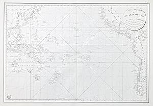
Carte Reduite du Grand Ocean compris entre l'Asie et l'Amerique" - Australia America Pacific Ocean / World Map Weltkarte
Published by Paris, 1818
Seller: Antiquariat Steffen V�lkel GmbH, Seubersdorf, Germany
Seller Rating:
Map
Gro�formatige Kupferstich-Karte aus dem 19. Jh. -- Bildmasse: ca. 93 x 58 cm. -- gut erhalten. || Large copper engraved map from the 19th century. -- in good condition. || This significant and noteworthy map depicts Australia, America, and the Pacific region, showcasing the explorations of Jean-Francois de Galaup, Comte de La Perouse, following in the footsteps of Captain Cook. While focusing on coastal features, the map does not trace La Perouse's specific route, but it includes numerous rhumb lines. Sprache: Franz�sisch Gewicht in Gramm: 35.
