Order Total (1 Item Items):
Shipping Destination:

John Luffman Surveyor Cartographer William (1 results)
Skip to main search results
Product Type
- All Product Types
- Books (1)
- Magazines & Periodicals
- Comics
- Sheet Music
- Art, Prints & Posters
- Photographs
- Maps
-
Manuscripts &
Paper Collectibles
Condition
- All Conditions
- New
- Used
Binding
- All Bindings
- Hardcover
- Softcover
Collectible Attributes
- First Edition
- Signed
- Dust Jacket
- Seller-Supplied Images
- Not Printed On Demand
Seller Location
Seller Rating
-
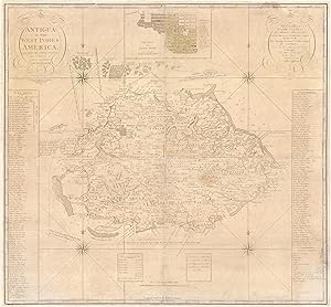
Antigua in the West Indies America. Laid Down by actual Survey, and engraved by John Luffman, in the years 1787 and 1788. / To His Excellency Major General Sir Thomas Shirley Governor Bart. Captain General & Governor in Chief in and over all His Majestys Leeward Caribee Islands, in America. Chancellor, Vice Admiral & Ordinary of the same. This Map is Dedicated, by his obliged humble Servant, John Luffman.
Published by London: William Faden, ., 1793
Seller: Antiquariat Dasa Pahor GbR, M�nchen, Germany
Seller Rating:

Copper engraving on 4 joined sheets (Good, several closed tears and cracks entering image but with no real loss, some surface abrasions along sheet joints, some light even toning and a light stain in lower right quadrant, some minor chips of filled loss to top neatline reinstated in facsimile, the entire map archivally mounted to a slightly larger sheet of japan for added stability; still a fine library example), 93.5 x 100.5 cm (37 x 39.5 inches). John Luffman s grand map of Antigua, one of the cartographic monuments of the 18th century British West Indies; predicated upon the goldsmith-cartographer s reconnaissance of the island conducted when it was still one of the world s leading sugar-slave economies, as well as hosting a major Royal Navy base (then commanded by the future Lord Admiral Horatio Nelson); the map served as the definitive geographic record of contemporary Antigua, granting a broadly accurate large-scale overview of the island s topography, detailing the locations of hundreds of plantations (with their owners names and their sources of power), as well as delineating its road network (with milage markers), outlining settlements and locating rural churches, plus, featuring a detailed inset plan of the island s capital, St. John s; published in London by William Faden, it amazignly served as the autorotative map of Antigua for 59 years! - Antigua was one of the first British colonies in the Caribbean, having been founded in 1632 by the great sugar baron Christopher Codrington, who brought setters over from St. Kitts. By the 1670s, Antigua had formed a highly profitable sugar-slave economy. The heyday of the island s agrarian bounty came in the 1760s, when it was the fourth largest sugar producer in the British Empire (next to Jamaica, Barbados, and St. Kitts) and one of the wealthiest places in the world (at least as far as Antigua s small white planter community was concerned). Meanwhile, from the 1740s, Antigua was home to an important Royal Navy dockyard, at English Harbour. In the run-up to the apogee of Antigua s sugar-slave economy, its legislature, backed by its major plantation owners, commissioned the island s surveyor-general, Robert Baker, to conduct the first serious survey of Antigua. This resulted in a grand-format and incredibly beautiful work that was the first broadly accurate map of the island, A New and Exact Map of the Island of Antigua in America, according to an Actual and Accurate Survey made in the years 1746, 1747 & 1748 (London: T. & J. Bowles, 1749).The map was the first to label all Antigua s estates, noting the names of their proprietors, while depicting its infrastructure and general topography. Importantly, Baker s mapping of Antigua was not precisely accurate, for it was not predicated upon systematic trigonometrical surveys. Prior to the 1760s, such surveys were very unusual in Britain and throughout its empire, and even if one were to be endeavored in Antigua, it would have been prohibitively expensive, while many of the island s landowners might not have wanted to have the bounds of their estates precisely demarcated, as the result might see them liable for higher taxes (a certain level of ambiguity in the size of plantations and their holdings allowed one to 'fudge a bit on their financial obligations to the crown!). As such, Baker employed a m�lange of surveying methods, with certain key areas being a mapped by systematic plain table and chain surveys, while the itinerary surveys of the roads would have sufficed for the bulk of the island. Indeed, most everybody an Antigua would have been happy with a broadly accurate rendering of their island, as an exact impression was seen as unnecessary, and even undesirable. While sugar remained important and was the only crop that could be sustained upon a mass-scale in Antigua, as it was less fertile than the other great sugar islands, from 1770s onwards its soils gradually became depleted, such that its annual crops yields diminished. However, the island s excellent location, immediately along the main West Indies-Europe shipping routes, aided by the stellar nature of Saint John s Harbour, supported a booming mercantile trade independent of the sugar industry, while the fixed naval establishment proved a reliable support to the economy. SEE OUR WEB PAGE FOR A LONGER DESCRIPTION.