
Order Total (1 Item Items):
Shipping Destination:

Collins World Wall Paper (8 results)
Skip to main search results
Product Type
- All Product Types
- Books (8)
- Magazines & Periodicals
- Comics
- Sheet Music
- Art, Prints & Posters
- Photographs
- Maps
-
Manuscripts &
Paper Collectibles
Condition
Binding
- All Bindings
- Hardcover
- Softcover
Collectible Attributes
- First Edition
- Signed
- Dust Jacket
- Seller-Supplied Images (3)
- Not Printed On Demand
Free Shipping
Seller Location
Seller Rating
-

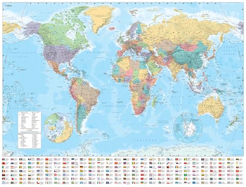
Collins World Wall Paper Map (Map)
Published by HarperCollins Publishers, London, 2022
ISBN 10: 0008492557ISBN 13: 9780008492557
Book
Map. Condition: new. Map. Explore the world with a Collins wall map Fully updated world map to include the latest political changes. The map contains politically coloured mapping which shows each country and their capital city, major roads, railways and cities and towns clearly. Also included are national flags, key statistics for every country and inset maps of the polar regions.The map is printed on high quality paper and comes rolled in a plastic tube ideal as a poster for any classroom, bedroom or office wall.Area of coverage:All of the world, centred on the Greenwich Meridian, and including maps of the North and South Pole regions.Scale:1:22 000 000; 1 cm to 220 km; 1 inch to 347 milesSize:1015 x 1380 mm (40 x 54 inches)Other versions available:Laminated flat map in tube (ISBN 978-0-00-821156-1). Explore the world with a Collins wall map Shipping may be from multiple locations in the US or from the UK, depending on stock availability.
-
Collins World Wall Paper Map
Published by Collins, 2022
ISBN 10: 0008492557ISBN 13: 9780008492557
Book
Condition: New. Book is in NEW condition.
-
Collins World Wall Paper Map
Published by Collins, 2022
ISBN 10: 0008492557ISBN 13: 9780008492557
Book
Condition: Good. Book is in Used-Good condition. Pages and cover are clean and intact. Used items may not include supplementary materials such as CDs or access codes. May show signs of minor shelf wear and contain limited notes and highlighting.
-
Collins World Wall Paper Map
Published by Collins, 2022
ISBN 10: 0008492557ISBN 13: 9780008492557
Book
Condition: Fine. Book is in Used-LikeNew condition. Pages and cover are clean and intact. Used items may not include supplementary materials such as CDs or access codes. May show signs of minor shelf wear.
-
Collins World Wall Paper Map
Published by Collins, 2022
ISBN 10: 0008492557ISBN 13: 9780008492557
Book
Condition: Very Good. Book is in Used-VeryGood condition. Pages and cover are clean and intact. Used items may not include supplementary materials such as CDs or access codes. May show signs of minor shelf wear and contain very limited notes and highlighting.
-
Collins World Wall Paper Map
Published by Collins, 2022
ISBN 10: 0008492557ISBN 13: 9780008492557
Book
Condition: New. New! This book is in the same immaculate condition as when it was published.
-
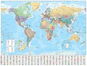
Collins World Wall Paper Map (Map)
Published by HarperCollins Publishers, London, 2022
ISBN 10: 0008492557ISBN 13: 9780008492557
Book
Map. Condition: new. Map. Explore the world with a Collins wall map Fully updated world map to include the latest political changes. The map contains politically coloured mapping which shows each country and their capital city, major roads, railways and cities and towns clearly. Also included are national flags, key statistics for every country and inset maps of the polar regions.The map is printed on high quality paper and comes rolled in a plastic tube ideal as a poster for any classroom, bedroom or office wall.Area of coverage:All of the world, centred on the Greenwich Meridian, and including maps of the North and South Pole regions.Scale:1:22 000 000; 1 cm to 220 km; 1 inch to 347 milesSize:1015 x 1380 mm (40 x 54 inches)Other versions available:Laminated flat map in tube (ISBN 978-0-00-821156-1). Explore the world with a Collins wall map Shipping may be from our Sydney, NSW warehouse or from our UK or US warehouse, depending on stock availability.
-

Collins World Wall Paper Map (Map)
Published by HarperCollins Publishers, London, 2022
ISBN 10: 0008492557ISBN 13: 9780008492557
Book
Map. Condition: new. Map. Explore the world with a Collins wall map Fully updated world map to include the latest political changes. The map contains politically coloured mapping which shows each country and their capital city, major roads, railways and cities and towns clearly. Also included are national flags, key statistics for every country and inset maps of the polar regions.The map is printed on high quality paper and comes rolled in a plastic tube ideal as a poster for any classroom, bedroom or office wall.Area of coverage:All of the world, centred on the Greenwich Meridian, and including maps of the North and South Pole regions.Scale:1:22 000 000; 1 cm to 220 km; 1 inch to 347 milesSize:1015 x 1380 mm (40 x 54 inches)Other versions available:Laminated flat map in tube (ISBN 978-0-00-821156-1). Explore the world with a Collins wall map Shipping may be from our UK warehouse or from our Australian or US warehouses, depending on stock availability.