Items related to Mercator Wall Map - Laminated and Tubed - 30x43"
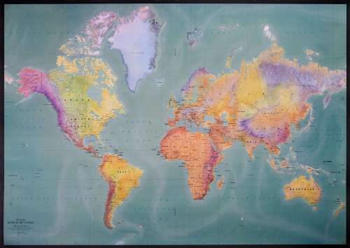

Laminated and gift-tubed in a blow-molded plastic screw tube. Makes a great gift! A cheaper version is available in an eco-friendly brown cardboard tube directly from ODT especially for schools. The most widely used map in the USA today for teaching geography is the Mercator projection map. This popularity is surprising, given the fact that Mercator constructed the map as a navigational aid. It may work well for sailors, but as an education tool it is markedly flawed because it distorts the actual size and relationship of land masses. When the Mercator projection was created in 1569, the custom among map-makers was to place their own country-in this case, Germany-at the center of the map. The Equator is placed 2/3 of the way down the map rather than halfway down. This arrangement depicts Europe as being larger than South America. In reality, South America is almost twice the size of Europe. Alaska appears to be three times larger than Mexico, although Mexico actually is larger than Alaska. On a Mercator map, Greenland looks larger than China, even though China actually is four times larger than Greenland. This map is a striking illustration that cartography is truly a mixture of art, science, personal viewpoint, and propaganda.
"synopsis" may belong to another edition of this title.
Review:
Mercator's 1569 edition was a large planisphere measuring 202 by 124 cm, printed in eighteen separate sheets. As in all cylindrical projections, parallels and meridians are straight and perpendicular to each other. In accomplishing this, the unavoidable east-west stretching of the map, which increases as distance away from the equator increases, is accompanied in the Mercator projection by a corresponding north-south stretching, so that at every point location the east-west scale is the same as the north-south scale, making the projection conformal. Being a conformal projection, angles are preserved around all locations. Because the linear scale of a Mercator map increases with latitude, it distorts the size of geographical objects far from the equator and conveys a distorted perception of the overall geometry of the planet. At latitudes greater than 70 degrees north or south the Mercator projection is practically unusable, since the linear scale becomes infinitely high at the poles. A Mercator map can therefore never fully show the polar areas (as long as the projection is based on a cylinder centered on the Earth s rotation axis; see the Transverse Mercator projection for another application). All lines of constant bearing (rhumbs or loxodromes those making constant angles with the meridians) are represented by straight segments on a Mercator map. The two properties, conformality and straight rhumb lines, make this projection uniquely suited to marine navigation: courses and bearings are measured using wind roses or protractors, and the corresponding directions are easily transferred from point to point, on the map, with the help of a parallel ruler or a pair of navigational protractor triangles. The name and explanations given by Mercator to his world map (Nova et Aucta Orbis Terrae Descriptio ad Usum Navigantium Emendata: "new and augmented description of Earth corrected for the use of sailors") show that it was expressly conceived for the use of marine navigation. Although the method of construction is not explained by the author, Mercator probably used a graphical method, transferring some rhumb lines previously plotted on a globe to a square graticule (grid formed by lines of latitude and longitude), and then adjusting the spacing between parallels so that those lines became straight, making the same angle with the meridians as in the globe. The development of the Mercator projection represented a major breakthrough in the nautical cartography of the 16th century. However, it was much ahead of its time, since the old navigational and surveying techniques were not compatible with its use in navigation. Two main problems prevented its immediate application: the impossibility of determining the longitude at sea with adequate accuracy and the fact that magnetic directions, instead of geographical directions, were used in navigation. Only in the middle of the 18th century, after the marine chronometer was invented and the spatial distribution of magnetic declination was known, could the Mercator projection be fully adopted by navigators. --Wikipedia
Why do maps always show the north as up? For those who don t just take it for granted, the common answer is that Europeans made the maps and they wanted to be on top. But there s really no good reason for the north to claim top-notch cartographic real estate over any other bearing, as an examination of old maps from different places and periods can confirm. The profound arbitrariness of our current cartographic conventions was made evident by McArthur s Universal Corrective Map of the World, an iconic upside down view of the world that recently celebrated its 35th anniversary. Launched by Australian Stuart McArthur on Jan. 26, 1979 (Australia Day, naturally), this map is supposed to challenge our casual acceptance of European perspectives as global norms. But seen today with the title Australia: No Longer Down Under, it s hard not to wonder why the upside-down map, for all its subversiveness, wasn't called Botswana: Back Where It Belongs or perhaps Paraguay Paramount! The McArthur map also makes us wonder why we are so quick to assume that Northern Europeans were the ones who invented the modern map and decided which way to hold it in the first place. As is so often the case, our eagerness to invoke Eurocentrism displays a certain bias of its own, since in fact, the north s elite cartographic status owes more to Byzantine monks and Majorcan Jews than it does to any Englishman. There is nothing inevitable or intrinsically correct not in geographic, cartographic or even philosophical terms about the north being represented as up, because up on a map is a human construction, not a natural one. Some of the very earliest Egyptian maps show the south as up, presumably equating the Nile s northward flow with the force of gravity. And there was a long stretch in the medieval era when most European maps were drawn with the east on the top. If there was any doubt about this move s religious significance, they illuminated it with their maps pious illustrations, whether of Adam and Eve or Christ enthroned. In the same period, Arab map makers often drew maps with the south facing up, possibly because this was how the Chinese did it. --america.aljazeera + opinions/2014/2/maps-cartographycolonialismnortheurocentricglobe.html
Why do maps always show the north as up? For those who don t just take it for granted, the common answer is that Europeans made the maps and they wanted to be on top. But there s really no good reason for the north to claim top-notch cartographic real estate over any other bearing, as an examination of old maps from different places and periods can confirm. The profound arbitrariness of our current cartographic conventions was made evident by McArthur s Universal Corrective Map of the World, an iconic upside down view of the world that recently celebrated its 35th anniversary. Launched by Australian Stuart McArthur on Jan. 26, 1979 (Australia Day, naturally), this map is supposed to challenge our casual acceptance of European perspectives as global norms. But seen today with the title Australia: No Longer Down Under, it s hard not to wonder why the upside-down map, for all its subversiveness, wasn't called Botswana: Back Where It Belongs or perhaps Paraguay Paramount! The McArthur map also makes us wonder why we are so quick to assume that Northern Europeans were the ones who invented the modern map and decided which way to hold it in the first place. As is so often the case, our eagerness to invoke Eurocentrism displays a certain bias of its own, since in fact, the north s elite cartographic status owes more to Byzantine monks and Majorcan Jews than it does to any Englishman. There is nothing inevitable or intrinsically correct not in geographic, cartographic or even philosophical terms about the north being represented as up, because up on a map is a human construction, not a natural one. Some of the very earliest Egyptian maps show the south as up, presumably equating the Nile s northward flow with the force of gravity. And there was a long stretch in the medieval era when most European maps were drawn with the east on the top. If there was any doubt about this move s religious significance, they illuminated it with their maps pious illustrations, whether of Adam and Eve or Christ enthroned. In the same period, Arab map makers often drew maps with the south facing up, possibly because this was how the Chinese did it. --america.aljazeera + opinions/2014/2/maps-cartographycolonialismnortheurocentricglobe.html
"About this title" may belong to another edition of this title.
- PublisherODTmaps & MapLink
- Publication date1993
- ISBN 10 1931057273
- ISBN 13 9781931057271
- BindingMap
- Edition number1
- Number of pages1
- IllustratorMap Link & ODTmaps
(No Available Copies)
Search Books: Create a WantIf you know the book but cannot find it on AbeBooks, we can automatically search for it on your behalf as new inventory is added. If it is added to AbeBooks by one of our member booksellers, we will notify you!
Create a Want