About this Item
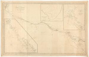
BLUNT, Edmund March (1770-1862) and George William BLUNT. West Coast of North America, from the Gulf of Dulce to San Francisco. New York: E. & G.W. Blunt, 1848. Single sheet (22 2/8 x 35 2/8 inches). Engraved chart of the western coast of North and Central America from the Gulf of Dulce to San Blas, with 3 insets laid down on blue paper for rolling (old folds). Provenance: with RIBA auction, 6/13/92; from the important cartographical library of Warren Heckrotte, his sale, Rare Cartography, Exploration and Voyages, Part II, December 3, 2015, Lot 99 A detailed and large scale map western coast of North and Central America from the Gulf of Dulce to San Blas, ON THE EVE OF THE CALIFORNIA GOLD RUSH, with three insets of the "Harbour of Monterey", "The Harbour of San Francisco", and Upper and Lower California, showing the coast from San Blas to San Francisco. Published near the end of the Mexican-American War (1845-1848), which gave the U.S. possession of Upper California, and showing the area that would become the state of California in 1850. Warren Heckrotte notes that he could find no direct references to this map, but comments extensively on parallel sources: "Re inset 2: Philo White in his 'Cruize in the Pacific' briefly notes the undertaking of the survey ofMonterey Bay (p 67): 'Capt. Dornin has directed some 5 or 6 officers to employ themselves in taking soundings in this Bay: Their survey will be, of necessity, quite superficial; yet will doubtless be useful, in ascertaining the true depth of water, etc.' Re inset 1: The part of California from San Diego north to Sutters bears a close resemblance to the manuscript map by Price of California, reproduced by W-TW 524. Price has more details, but those that are in Blunt correspond closely to those of Price, with only a few exceptions. The distinctive names of some of the rivers are identical, as well as their course. Price was purser aboard the US ship Cyane which returned to the eastcoast Oct 9, 1848. Wheat states that it must be a copy of an unidentified Mexican original. Another similar map is a manuscript map by Naglee, W-TW 550. He also notes a J.Calvin Smith map of 1847 which has some similar aspects; W-TW 552. This then explains in general way the source of Blunt's map". Blunt was one of "America s first hydrographers. He published some of the first nautical books and charts in the United States. The American Coast Pilot was first printed in 1796. It went through twenty-one editions before being taken over by the federal government in 1867. The American Coast Pilot provided sailing directions from Passamaquoddy, Maine, to the Strait of Florida. It included soundings and bearings of the lighthouses and beacons (such as there were) from rocks, shoals, ledges, etc. The volume also had courses and distances between numerous locations, settings of the currents, and tide tables. The book was extremely popular with ship owners and masters and lives on today as the Coast Pilot published by the National Oceanic and Atmospheric Administration (NOAA). In 1799, he retained Nathaniel Bowditch to update the British publication The New Practical Navigator and adapt it to American needs. The third edition, published in 1802, had been significantly altered from the original and was renamed as the American Practical Navigator. We know it now simply as Bowditch. Few people today are aware that the originator of both publications the Coast Pilot and Bowditch was Edmund Blunt. He also compiled some of the first detailed surveys of major US east coast ports, from Boston to Charleston. The standards he established in 1796 for accuracy and thoroughness continue today as a worthy legacy to a major, but largely forgotten, figure in American nautical history" (Dennis Bryant, "Edmund M. Blunt: Forgotten Pioneer of Nautical Charting and Publishing in the United States" in Maritime Musings, January 2010). Seller Inventory # 72map392
Contact seller
Report this item
![]()
