Order Total (1 Item Items):
Shipping Destination:

Carey, Henry Charles and Isaac Lea Publishers (4 results)
Skip to main search results
Product Type
- All Product Types
- Books (3)
- Magazines & Periodicals
- Comics
- Sheet Music
- Art, Prints & Posters
- Photographs
- Maps (1)
-
Manuscripts &
Paper Collectibles
Condition
- All Conditions
- New
- Used
Binding
- All Bindings
- Hardcover (2)
- Softcover
Collectible Attributes
- First Edition
- Signed
- Dust Jacket
- Seller-Supplied Images
- Not Printed On Demand
Free Shipping
Seller Location
Seller Rating
-
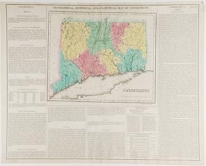
Connecticut. Geographical, Historic and Statistical Map of Connecticut
Published by Carey & Lea, Philadelphia, 1823
Seller: Donald A. Heald Rare Books (ABAA), New York, NY, U.S.A.
Seller Rating:

Map
Engraving with full period colour. Backed on linen. Split at fold expertly repaired. Occasional creases. Fascinating and informative map of Connecticut from one of the most innovative American atlases of the 19th century. Carey & Lea's atlas established a style that was widely admired, especially in Europe: placing a fully coloured map as the centerpiece of the page and surrounding it with geographical and historical facts. The texts were well written and intriguing. The immense transformation of continental America: the vast migration, settlement and industrialization really began at about this time, not long after the War of 1812, when expansion and opportunity were American by-words. It was at this time that American atlases began to need semi-annual revisions because the country had changed so rapidly. In fact, the Carey & Lea gazetteer style, most reminiscent of Herman Moll really, was too time consuming for the firms that published atlases of America as the century progressed.
-
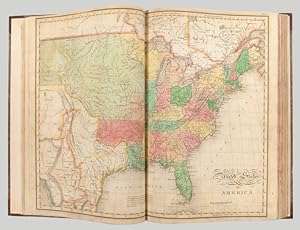
A Complete Historical, Chronological, and Geographical American Atlas, being a guide to the history of North and South America, and the West Indies: exhibiting an accurate account of the discovery, settlement, and progress, of their various kingdoms, states, provinces, &c. Together with the wars, celebrated battles, and remarkable events, to the year 1822
Published by H.C. Carey & I. Lea, Philadelphia, 1823
Seller: Donald A. Heald Rare Books (ABAA), New York, NY, U.S.A.
Seller Rating:
Folio. (17 1/2 x 11 7/8 inches). Mounted on guards throughout, letterpress title (copyright notice on verso), 1p. Advertisement (verso blank), 1p. Contents (verso blank), 46 double-page hand-coloured engraved maps of the United States, all but one with borders of letterpress descriptive text, 1 uncoloured double-page engraved view showing the comparative heights of mountains throughout the world, 1 hand-coloured double-page engraved table showing the comparative lengths of the principal rivers worldwide, 5 letterpress tables (4 double-page [3 of these hand-coloured]), 18pp. of letterpress text. Expertly bound to style in half calf over contemporary marbled paper covered boards, flat spine in six compartments divided by gilt roll tools, red morocco label in the second compartment, the others with a repeat decoration in gilt. One of the most important early atlases printed in the United States: a handsome atlas of the Americas, with individual colour maps of each state in the Union, including a seminal map of the West by Stephen H. Long. At the time of publication this was the best and most detailed atlas to be produced in the United States. Fielding Lucas, the major Baltimore printer, was the principal engraver and substantial historical background text accompanies each map. Among the most noted maps in the atlas is Major Stephen H. Long's "Map of Arkansa and other Territories of the United States." That map, which depicts the Missouri basin between Nashville in the east, the Mandan villages in the north and the Rocky Mountains in the west, was based on the surveys conducted by Long on his expeditions of 1819 and 1820. The map published in Carey & Lea's atlas preceded the official account of that expedition by expedition botanist Edwin James, which included a smaller map with similar detail (titled "Country drained by the Mississippi Western Section"). Carey and Lea's 1823 publication of James Account perhaps explains the prior inclusion of this map with Long expedition information in their atlas. On this famous map is the printed legend, which would perpetuate a myth for many years to come, identifying the high plains as the "Great American Desert." Carey and Lea's atlas was first issued in 1822; this is the 1823 second issue, substantially the same as the first but with a new title and revised states of several maps and text leaves (generally minor revisions, including additional shading to maps and improved resetting of several text leaves, though this copy with first state settings of the Maryland and Virginia text leaves). Howes C133 ("aa"); Phillips 1373a; Sabin 15055; Wheat, Transmississippi West 348 and 352; Phillips 'Atlases' 4464.
-
A Complete Historical, Chronological, and Geographical American Atlas, being a guide to the history of North and South America, and the West Indies: exhibiting an accurate account of the discovery, settlement, and progress, of their various kingdoms, states, provinces, &c. Together with the wars, celebrated battles, and remarkable events, to the year 1822
Published by H.C. Carey & I. Lea, Philadelphia, 1823
Seller: Donald A. Heald Rare Books (ABAA), New York, NY, U.S.A.
Seller Rating:
Folio. (17 1/2 x 11 7/8 inches). Mounted on guards throughout, letterpress title (copyright notice on verso), 1p. advertisement (verso blank), 1p. contents (verso blank). 46 double-page hand-coloured engraved maps of the United States, all but one with borders of letterpress descriptive text, 1 uncoloured double-page engraved view showing the comparative heights of mountains throughout the world, 1 handoloured double-page engraved table showing the comparative lengths of the principal rivers worldwide, 5 letterpress tables (4 double-page [3 of these hand-coloured]), 18pp. of uncoloured letterpress text. Expertly bound to style in half dark green straight grained morocco over contemporary marbled paper covered boards One of the most important early atlases printed in the United States: a handsome atlas of the Americas, with individual colour maps of each state in the Union, including a seminal map of the West by Stephen H. Long. At the time of publication this was the best and most detailed atlas to be produced in the United States. Fielding Lucas, the major Baltimore printer, was the principal engraver and substantial historical background text accompanies each map. Among the most noted maps in the atlas is Major Stephen H. Long's "Map of Arkansa and other Territories of the United States." That map, which depicts the Missouri basin between Nashville in the east, the Mandan villages in the north and the Rocky Mountains in the west, was based on the surveys conducted by Long on his expeditions of 1819 and 1820. The map published in Carey & Lea's atlas preceded the official account of that expedition by expedition botanist Edwin James, which included a smaller map with similar detail (titled "Country drained by the Mississippi Western Section"). Carey and Lea's 1823 publication of James Account perhaps explains the prior inclusion of this map with Long expedition information in their atlas. On this famous map is the printed legend, which would perpetuate a myth for many years to come, identifying the high plains as the "Great American Desert." Carey and Lea's atlas was first issued in 1822; this is the 1823 second issue, substantially the same as the first but with a new title and revised states of several maps and text leaves (generally minor revisions, including additional shading to maps and improved resetting of several text leaves). Howes C133 ("aa"); Phillips 1373a; Sabin 15055; Wheat, Transmississippi West 348 and 352.
-
A COMPLETE HISTORICAL, CHRONOLOGICAL, AND GEOGRAPHICAL AMERICAN ATLAS, BEING A GUIDE TO THE HISTORY OF NORTH AND SOUTH AMERICA, AND THE WEST INDIES: EXHIBITING AN ACCURATE ACCOUNT OF THE DISCOVERY, SETTLEMENT, AND PROGRESS, OF THEIR VARIOUS KINGDOMS, STATES, PROVINCES, &c. TOGETHER WITH THE WARS, CELEBRATED BATTLES, AND REMARKABLE EVENTS, TO THE YEAR 1822
Published by H.C. Carey & I. Lea, Philadelphia, 1823
Seller: William Reese Company - Americana, New Haven, CT, U.S.A.
Association Member: ABAA ESA ILAB SNEAB
Seller Rating:

Letterpress title (copyright notice on verso), 1p. advertisement (verso blank), 1p. table of contents (verso blank). Forty-six double-page handcolored engraved maps of the United States, all but one with borders of letterpress descriptive text; uncolored double-page engraved view showing the comparative heights of mountains throughout the world; handcolored double-page engraved table showing the comparative lengths of the principal rivers worldwide; five letterpress tables (four double-page [three of these handcolored]); 18pp. of letterpress text. Mounted on guards throughout. Modern half calf and marbled boards, spine gilt, leather label. Dampstaining along lower edge, causing chipping to initial leaves. Closed tear in bottom margin of first map, repaired with tissue. Very light offsetting from maps. Some dust soiling, light tanning and foxing. Good plus. A handsome atlas of the Americas, with individual color maps of each state in the Union, including a seminal map of the West by Stephen H. Long. At the time of publication this was the best and most detailed atlas to be produced in the United States, with substantial historical background text accompanying each map. Fielding Lucas, the major Baltimore printer, was the principal engraver. Among the most noted maps in the atlas is Major Stephen H. Long's "Map of Arkansa and other Territories of the United States." That map, which depicts the Missouri basin between Nashville in the east, the Mandan villages in the north, and the Rocky Mountains in the west, was based on the surveys conducted by Long on his expeditions of 1819 and 1820. The map published in Carey & Lea's atlas preceded the official account of that expedition by expedition botanist Edwin James, which includes a smaller map with similar detail, titled "Country drained by the Mississippi Western Section." Carey & Lea's 1823 publication of James' ACCOUNT perhaps explains the prior inclusion of this map with Long expedition information in their atlas. On this famous map is the printed legend, which would perpetuate a myth for many years to come, identifying the high plains as the "Great American Desert." Carey & Lea's atlas was first issued in 1822; this is the second issue, with revised states of three maps (Maine, North Carolina, and Louisiana), with the same printing of the remaining maps and a cancel title. HOWES C133, "aa." PHILLIPS ATLASES 1373a. SABIN 15055. WHEAT TRANSMISSISSIPPI 348, 352.