
Order Total (1 Item Items):
Shipping Destination:

Custos, David (4 results)
Skip to main search results
Search filters
Product Type
- All Product Types
- Books (No further results match this refinement)
- Magazines & Periodicals (No further results match this refinement)
- Comics (No further results match this refinement)
- Sheet Music (No further results match this refinement)
- Art, Prints & Posters (3)
- Photographs (No further results match this refinement)
- Maps (1)
- Manuscripts & Paper Collectibles (No further results match this refinement)
Condition Learn more
- New (No further results match this refinement)
- As New, Fine or Near Fine (No further results match this refinement)
- Very Good or Good (1)
- Fair or Poor (No further results match this refinement)
- As Described (3)
Binding
- All Bindings
- Hardcover (No further results match this refinement)
- Softcover (No further results match this refinement)
Collectible Attributes
- First Edition (No further results match this refinement)
- Signed (No further results match this refinement)
- Dust Jacket (No further results match this refinement)
- Seller-Supplied Images (3)
- Not Print on Demand (4)
Language (1)
Price
- Any Price
- Under US$ 25 (No further results match this refinement)
- US$ 25 to US$ 50 (No further results match this refinement)
- Over US$ 50
Free Shipping
- Free Shipping to U.S.A. (No further results match this refinement)
Seller Location
Seller Rating
-
Typus oder Abri� des Hertzogthumbs Brunschwig und umliegenden Landschafften (Herzogtum Braunschweig).
Published by Nicolaus Bellus, Frankfurt a. M., 1625
Map
Condition: Gut. Gut. Kupferstich, altkoloriert. Blattgr��e: 32 x 37 cm, Druckspiegel: 26,5 x 31,3 cm. . Guter und gleichm��iger Druck auf an den R�ndern etwas st�rker gebr�untem Papier, linke obere Ecke restauratorisch hinterlegt, insgesamt gut erhalten. Sch�ne altkolorierte Landkarte des Herzogtums Braunschweig, die Harzregion im Zentrum (Goslar, Wernigerode, Halberstadt und Quedlinburg bis Magdeburg). Unten links sch�ne Beschlagwerkkartusche. Landkarte, map, carte g�ographique, carta geografica, Deutschland, Heiliges R�misches Reich Deutscher Nation, Braunschweig, L�neburg, Welfen, Sachsen, Hannover. 2100 Gramm.
-
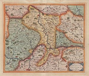
Tractus Renicum Confinibus oder Rheijnstrom. -
Published by Frankfurt a.M.: Johann T. Sch�nwetter [], 1627
Seller: Antiquariat Tautenhahn, L�beck, Germany
Association Member: GIAQ ILAB VDA
Seller rating 5 out of 5 stars

Art / Print / Poster
Kupferstich, 26 x 31,5 cm Bildgr��e, 31 x 37,5 cm Blattgr��e. Der Kupferstich von David Custos in leuchtendem Altkolorit zeigt den Rheinlauf zwischen Speyer und D�sseldorf. Mittig im Bild die Mosel. Dabei ist Westen am oberen Bildrand, Osten am unteren, Norden an der rechten und S�den an der linken Bildseite. Frankfurt am unteren Bildrand, am oberen Saarburg. Unten rechts eine schlichte Titelkartusche, am unteren Bildrand der Verfasser. Aus: Michael Lundorp, Laurea Austriaca. Drei zarte Quetschfalten, leichte Br�une im Bereich des fr�heren Passepartoutausschnittes, r�ckseitig Spuren alter Einrahmung. Die Karte besticht durch das sch�ne, fl�chendeckende Altkolorit und durch die einfache, teils naiv anmutende Darstellung der geographischen Symbole f�r Wald und Berge.
-

Abriss der Landschafft Veltlin vom frantz?sischen General Marquis di Covure den Spanischen wieder abgenommen worden
Published by Francoforte, 1627
Seller: libreria antiquaria perini Sas di Perini, Verona, VR, Italy
Seller rating 5 out of 5 stars
Art / Print / Poster
Incisione in rame, mm 245x345. Orientata a sud, questa carta � uno dei molti rari prodotti editoriali che puntava ad informare il pubblico sulla situazione valtellinese, teatro di guerra fra Francesi e Spagnoli durante le guerre religiose che insanguinarono la valle nella prima met? del secolo. Tratta da "Ostreichischer Lorberkrantz" di N.K. Bellus. Buon esemplare con restauri alla piega centrale e margine destro professionalmente aggiunto. Sceffer 27; Bianchi 61.Copper engraving, mm 245x345. Oriented to the south, this map is one of many rare editorial products that aimed to inform the public about the situation in Valtellina, a theater of war between the French and Spanish during the religious wars that bloodied the valley in the first half of the century. Taken from "Ostreichischer Lorberkrantz" by N.K. Bellus. Nice copy with some restoration at centrefold and right margin professionally added. Sceffer 27; Bianchi 61. Nr.cat: Cod 7233.
-

Italiae nova et exacta descriptio.
Published by Augsburg,, 1625
Seller: libreria antiquaria perini Sas di Perini, Verona, VR, Italy
Seller rating 5 out of 5 stars
Art / Print / Poster
Incisione in rame, 225x305. Non comune. Bell'esemplare. Borri, 91. Nr.cat: 774.

