Order Total (1 Item Items):
Shipping Destination:

E Andriveau Goujon (30 results)
Skip to main search results
Product Type
- All Product Types
- Books (23)
- Magazines & Periodicals
- Comics
- Sheet Music
- Art, Prints & Posters
- Photographs
- Maps (7)
-
Manuscripts &
Paper Collectibles
Condition
- All Conditions
- New
- Used
Binding
Collectible Attributes
- First Edition (1)
- Signed
- Dust Jacket
- Seller-Supplied Images (22)
- Not Printed On Demand
Seller Location
Seller Rating
-

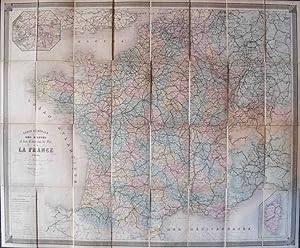
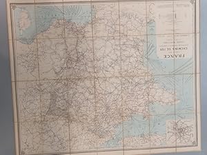
Carte sp�ciale des chemins de fer, des routes et des voies navigables de la France d'apr�s les meilleurs documents.
Published by E. Andriveau-Goujon, 1880
Couverture rigide. Condition: Satisfaisant. 0 Couverture et dos d'usage. GLN-65. . La librairie Aux Livres Anciens et Contemporains offre aux clients d'AbeBooks 30% de r�duction sur l'ensemble de son catalogue. Prix d'origine : 56 EUR. Livre.
-
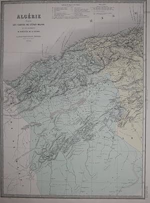
Carte de l'Alg�rie, d'apr�s les cartes de l'Etat-Major et les documents du Minist�re de la Guerre. Aus "Atlas Usuel"
Published by Paris, 1876
Map
Condition: Gut. 45 x 62 cm (Blattgr��e: 70 x 52,5 cm). *Sauber und gut erhalten. Sprache: Franz�sisch Gewicht in Gramm: 1000.
-
Condition: Gut. 62 x 46 cm. (Blattgr��e: 70 x 52,5 cm). *Sauber und gut erhalten. Sprache: Franz�sisch Gewicht in Gramm: 1000.
-
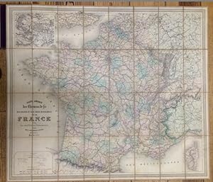
Carte Speciale des Chemins de fer des routes et des voies navigables de la France d'apres les meilleurs Documents.
Published by Paris., 1886
Seller: Antiquariat Cassel & Lampe Gbr - Metropolis Books Berlin, Berlin, D, Germany
Seller Rating:

95,5 x 83 cm Stahlstichkarte. Orig.-Leinen mit Deckeltitelvergoldung. Einbandr�cken etwas berieben. Gro�formatige auf Leinen aufgezogene mehrfarbige Karte Frankreichs. Mit Randdarstellungen von Paris und Korsika. - Kartenr�ckseite in zwei Segmenten fleckig. Sprache: Franz�sisch.
-
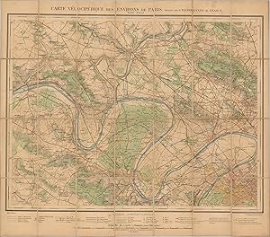
Carte Velocipedique des Environs de Paris Detailed cycling map of the northeast suburbs of Paris from the late 19th century.
Publication Date: 1895
Seller: Curtis Wright Maps, Berwyn, IL, U.S.A.
Seller Rating:
Condition: Very Good. Prior to the widespread use of the automobile, cyclists were some of the earliest proponents for improved road surfaces, especially in and around major urban areas. Europe was at the forefront of this trend, and Parisians 'wheelmen' (or women) were no exception. This map, published by E. Andriveau-Goujon in 1895, provides a detailed overview of the road network of the suburbs that can be found immediately northeast of Paris (seen in the lower right). Various surface levels and route types are explained in the legend along the bottom of the sheet, which also details the symbols used to identify other transportation routes, chateaus, churches, post offices, telegraph bureaus, and more. A useful and practical guide to cycling the French countryside in the late 19th century. Sheet Width (in) 29.5 Sheet Height (in) 25.75 Condition Description Dissected into 28 panels and mounted onto linen. Scattered soiling throughout, notably a spot just above the scale (bottom of the sheet) and darkening along fold lines on the right side. Remains in good to very good condition overall.
-
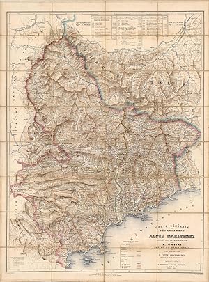
Carte General du Departement des Alpes Maritimes (Map of the Department of Alpes Maritimes)
Publication Date: 1865
Covering the South-east section of France, from Nice up through Saint-'tienne, this map covers the area of the Alpes in this region, published in 1865. This is a beautiful antique map that shows roads, townships, highways, and gives detailed length of those routes. The original canvas backing is in very good condition.This map measures 37.25 inches by 27.5 inches.
-
Atlas Universal. Hoja 629. Toledo. Formado y publicado por el Instituto Geogr�fico y Estad�stico.
Seller: Librer�a Anticuaria Antonio Mateos, Malaga, Spain
Seller Rating:

M., 1882, mapa de 40 x 61 cm., coloreado, forrado en tela y doblado en cuarterones. LOCAL CASTILLA TOLEDO.
-
Paris, E. Andriveau-Goujon, 1866. 82,5 x 95 cm, percaline de l'�diteur, d�cor � froid et dor� sur le premier plat, d�cor � froid sur le second (plat d�tach�, frottements, quelques rousseurs) Cartes des voies ferr�es en France sous le Second empire. Elle est compos�e de 32 feuillets coll�s sur une toile brune. et comprend un cartouche dans le coin sup�rieur gauche consacr� � la ville de Paris. Elle est rehauss�e de couleurs, les chemins de fer sont d'Alfred Potiquet, le trait de Smith, la lettre de Rousset et Langevin, les montagnes de G�rin. Voir photographie(s) / See picture(s).
-
Carte Generale des Routes et des Chemins de Fer de La France
Published by Paris, Paris, 1895
Seller: High Ridge Books, Inc. - ABAA, South Deerfield, MA, U.S.A.
Association Member: ABAA ESA ILAB SNEAB
Seller Rating:
Bright colorful map of France, dissected and mounted on linen, showing all rail lines through France. Original cloth binding with title gilt on front. Excellent condition. Inset maps of Corsica and the vicinity of Paris. Full color by department.
-
Etat-Major. Nouvelle carte de France (�chelle) 1/80.000
Paris, E. Andriveau-Goujon, Nouvelle �dition, s.d ( ca. 1870) 60 x 48 cm, carte mont�e sur toile, divis�e en 16 sections. Pli�e dans un portfolio de l'�diteur en toile verte. Avec titre en or sur le plat sup�rieur. Avec l'�tiquette (ovale-octagonale) de l'�diteur coll. � l'interieur. Tr�s bel �tat. La carte d�crit la section de Calais jusqu'� sud de Boulogne.
-
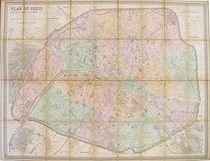
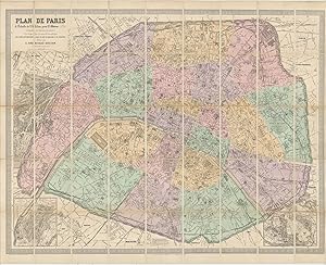
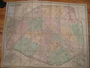
Plan de Paris � l'�chelle de 2 millim�tres pour 25 m�tres indiquant les nouveaux percements et les changements de noms de voies publiques avec plans suppl�mentaires pour les Bois de Boulogne et de Vincennes
Published by Andriveau-Goujon, Paris, 1876
Seller: Librairie Bonheur d'occasion (LILA / ILAB), Montr�al, QC, Canada
Seller Rating:
Couverture rigide toile. Condition: Tr�s bon. In-8 (pli�). Dimension de la carte : 32.5 cm x 41 cm. Sans l'index des rues. Int�ressant plan au lendemain des nombreuses transformations effectu�es par le Baron Haussmann : nouvelles voies, nouveaux parcs, etc.
-
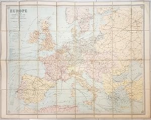
Folding map, dissected and backed with linen. Paper label. Splits along two folds mended. Full color by country. Rail lines highlighted. Extends west to the Aral Sea and Persian Gulf and south to include the northern coast of Africa. Designated as the 1893 revision at the bottom left.
-
CARTE GENERALE DE L'ALLEMAGNE comprenant l'ensemble des Etats de L'Europe Centrale. (Faltkarte von Deutschland).
Paris, E. Andriveau-Goujon, 1851, 63 x 92 cm, with border colouring, mounted on cloth, dissected into 21 sections, folding into a publisher's marbled paper portfolio (some discoloring of the cloth, but the whole in fine condition). Sch�ne franz�sische Faltkarte aus 1851 mit Randkolorierung. Die Namen von Orten, St�dte und L�nder (40) sind auf franz�sisch benennt.
-
Taille : 96 x 83 cm. Editions E. Andriveau-Goujon. Fran�ais Couverture l�g�rement frott�e. Tr�s bel �tat.
-
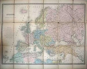
EUROPE. CHEMINS DE FER LIGNES T�L�GRAPHIQUES. COMMUNICATIONS MARITIMES
Published by Par�s, E. Andriveau, 1892
Map
Sin Encuadernar. Condition: Muy bien. 108 x 83cm. Map is dissected into 32 sections and backed with linen. Beautiful map containing all the European Communications and Railway, Maritime and Telegraphic Lines. CodBos.
-
Carte orographique hydrographique et routi�re de la France comprenant le Bassin du Rhin et la R�gion des Alpes Occidentales r�duite de la nouvelle Carte de France de l`�tat-Major dress�e au d�p�t de la guerre.
Published by Paris 1872., 1872
Les chemins de fer par Alfred Potiquet. 4 farblithpgr. Bll., zu je 61 x 68 cm., mehrf. gefalt., auf Leinen gezogen. in Schuber. Die Eintragungen der Eisenbahnlinien von A. Potiquet. Gewicht in Gramm: 750.
-
FRANCE - Carte des Camins de Fer avec stations, distances et compagnies. Lignes maritimes et ports desservis.
Published by Paris: Lan�e, Succr de Longuet, 1889
Condition: Bien. 980 x 845 mm. Entelado y en estuche de cart�n, este con rozaduras pero el mapa en perfecto estado.
-
Couverture rigide. Condition: Bon. un volume in plano (540 x 370mm), reliure en demi-chagrin rouge �poque, dos lisse orn� de l'auteur, du titre, de filets et de cha�nettes dor�.e.s, grande �tiquette de titre au premier plat. (SONT MANQUANTES LES 4 CARTES DE L' EMPIRE FRANCAIS num�rot�es 7 � 11, cerne claire en marge des gardes et de la derni�re carte, coupes frott�es par endroits, pr�sence de p�les rousseurs �parses sinon int�rieur frais). Atlas compos� de 27 cartes � double page en couleurs dont une mappemonde en deux h�misph�res. les cartes 7-8-9-10 sont manquantes. Ex-libris : " Biblioth�que du ch�teau de Paulhac ".
-
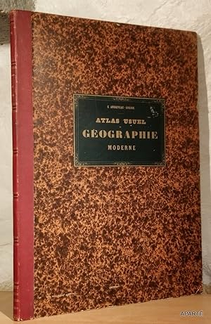
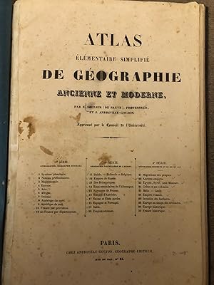
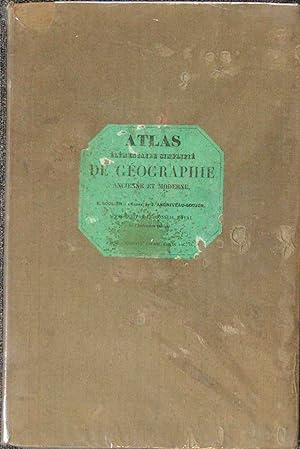
Atlas �l�mentaire simplifi� de g�ographie ancienne et moderne
Published by Paris, chez Andriveau-Goujon, (1850 c.ca), 1850
Seller: TABERNA LIBRARIA - ALAI - ILAB, Pistoia, Italy
Seller Rating:
In folio (cm.44x28), piena percallina con dorso ricostruito. Atlante composto da 30 tavv. litografiche + (1 doppia della Francia) colorate a doppia p., dieci delle quali inerenti la cosmografia e geografia generale (sistema planetario, mappamondi, continenti), dieci di geografia particolare d'Europa e dieci di geografia storica-antica.
-
. (illustrator). Paris. 1882. 122x135 cm. acuartelado, entelado, color. Grabado al acero, por: le Trait par Smith: la topographie par G�rin: les ecritures par P. Rousset: les Eaux par Fontaine. Plegado. Perfecto estado. # cartograf�a A. G.
-
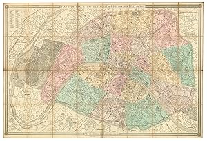
PLAN DE PARIS: A L'ECHELLE DE 2 MILLIM. POUR 25 METRES (1/12,500) AVEC PLANS SUPPLIMENTAIRES POUR LES BOIS DE BOULOGNE ET DE VINCENNES
Published by E. ANDRIVEAU-GOUJON, PARIS, 1884
Condition: VERY GOOD. FOLDING MAP: 43" x 33" HAND COLORED. 36 SHEETS MOUNTED ON LINEN IN A BROWN CLOTH BINDING WITH GOLD GILT LETTERING ON COVER AND SPINE. PUBLISHER'S LABEL ON BACK. INDEX TITLE PAGE/PAGE 2 LAID IN, PAGE 23/24 TIPPED IN, MISSING PAGES 3-22. COVER SHOWS WEAR. MAP IS NEAR FINE.
-
Plan de Paris. A l'Echelle de 2 Millim. pour 25 Metres (1/12,500). Indiquant les Nouveaux percements et les changements de noms de Voies publiques.
Published by ParisE. Andriveau-Goujon. 4 Rue du Bac, 1870
Seller: Robert Frew Ltd. ABA ILAB, London, United Kingdom
Association Member: ABA ILAB PBFA
Seller Rating:
Map
Map dimensions 79 x 102 cm, overall dimensions 82 x 106 cm. Large folding plan of Paris, engraved by P. Mea, printed by J. Monrocq, divided into squares, numbered and lettered to margins. Original colour demarcating the arrondisements. Inset maps of the Bois de Boulogne and the Bois de Vincennes to the lower corners. The whole dissected into 36 sections and mounted on linen, folds between original gilt lettered brown cloth boards (21 x 13 cm.), gilt lettered to upper cover. Front cover almost detached.
-
Atlas �l�mentaire simplifi� de geographie ancienne et moderne (.).
Seller: Libreria Oreste Gozzini snc, Firenze, FI, Italy
Seller Rating:
Paris, chez Andriveau-Goujon, (c. 1850), in-folio, legatura posteriore in piena tela muta, pp. (2), + 31 carte geografiche in litografia a colori (alcuni particolari colorati a mano): 11 di geografia generale, 10 di geografia particolare dell'Europa, 10 di geografia antica e medioevale. Qualche macchia e brunitura. Un piccolo foro alla carta dell'Austria.
-
Nouveau Plan de Paris indiquant les arrondissements et les quartiers ainsi que le percements executes et projetes.
Published by Dresse par Achinet Alfred Potiquet, Paris, 1867
Seller: Kurt Gippert Bookseller (ABAA), Chicago, IL, U.S.A.
Association Member: ABAA ILAB MWABA
Seller Rating:
First Edition
No Binding. Condition: Very good+ condition. First thus edition. Large antique folding map of Paris: measures 39 x 30.5 inches, in 32 sections. Linen backed. Hand-colored lithograph folding pocket map. Hardcover case, impressed by Auguste Fontaine, purveyor. Book.
-
Atlas Elementaire Simplifie de Geographie Ancienne et Moderne
Published by Paris c. 1841, Paris, 1841
Seller: High Ridge Books, Inc. - ABAA, South Deerfield, MA, U.S.A.
Association Member: ABAA ESA ILAB SNEAB
Seller Rating:
Later full cloth with original paper label laid down. 31 maps, 21 of the modern world, much on Europe, 10 of the ancient world. The list of maps on the title page indicates that the work is divided into three groups of 10 maps each, but the first group actually has 11 maps, with two maps of France. One is by province, the other by department. An early atlas from Andriveau-Goujon, one of the leading cartographic firms in 19th century France, with a less refined style than their later maps. The simplified style is more reminiscent of utilitarian American maps than the decorative European styles of the 18th and 19th centuries, though the bright full color makes the maps quite attractive. Phillips 324.
-
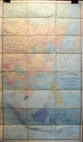
Asie Orientale Comprenant l'Empire Chinois et le Japon, les etats de l'Indo-Chine .
Published by Paris, Paris, 1862
Seller: High Ridge Books, Inc. - ABAA, South Deerfield, MA, U.S.A.
Association Member: ABAA ESA ILAB SNEAB
Seller Rating:
Very large, bright colorful map of Asia from Russia to the northern tip of Australia. Extends to Burma and the very eastern tip of India. Dissected and mounted on linen. Original paper label. Fine condition. Full color by country. A scarce, very attractive map of Eastern Asia.
-
Plan g�om�tral de Paris et de ses agrandissements � l'�chelle d'un millim�tre pour 10 m. [ Plan de Paris en couleurs - 1869 ]
Published by E. Andriveau-Goujon, 1867
Map
souple. 1 carte entoil�e d�pliante sous chemise cartonn�e et �tui au format 104 x 156 cm, en couleurs, E. Andriveau-Goujon, Paris, 1867 Rare et bon exemplaire de cette carte de Paris en grand format, nous pr�sentant la capitale � la fin du Second Empire, � la veille du Si�ge de Paris et de la Commune (la chemise est ab�m�e, l'�tui est en bon �tat). D'une �chelle et d'un format sup�rieur aux autres productions d'Andriveau-Goujon, elle englobe l'int�gralit� de la boucle de la Seine avec Boulogne et son bois, jusqu'� Saint-Cloud et Suresnes. Langue: Fran�ais.
-
rigide. 1 vol. in-folio reliure demi-chagrin noir, Andriveau-Goujon, s.d. [ circa 1876 ], 2 ff. et 32 grandes cartes doubles en couleurs Etat tr�s satisfaisant (la carte 11 manquante a �t� rajout�e par une carte d'un autre exemplaire bruni et imprim� sur papier de moindre qualit�, petits accrocs � 2 cartes en marge int�rieure, qq. cartes d'autres atlas contrecoll�es au verso des cartes, rel. un peu frott�e, bon �tat et belle fra�cheur int�rieure par ailleurs) pour ce bel atlas imprim� sur beau papier. Langue: Fran�ais.
-
Plan G�ometral de Paris � l'Echelle de 0.001 pour 10 M�tres (1/10,000).
Published by ParisE. Andriveau-Goujon 4 Rue du Bac. ., 1891
Seller: Robert Frew Ltd. ABA ILAB, London, United Kingdom
Association Member: ABA ILAB PBFA
Seller Rating:
Map
Overall dimensions 105 x 154cm. Large folding map of Paris in original block colour, within printed border, with inset key to the arrondissements and their quartiers, dissected into 32 sections and mounted on linen, publisher's printed label to folded end section (26 x 19cm) on linen verso. Publisher's label torn with loss, generally very good.
-
Plan de Paris a l'echelle de 2 Millim. pour 25 M�tres indiquant les Nouveaux percements et les changements de nom de Voies publiques avec plans supplementaires pour les Bois de Boulogne et de Vincennes.
Published by ParisE. Andriveau-Goujon 4 Rue du Bac ., 1878
Seller: Robert Frew Ltd. ABA ILAB, London, United Kingdom
Association Member: ABA ILAB PBFA
Seller Rating:
Map
Original colour-lithographed map of Paris (86 x 100 cm) "grav� sur pierre" by P. Mea and printed by Monrocq, dissected into 45 sections and mounted onto linen, folding between purple cloth slipcase with Edward Stanford's yellow label to upper portion (Stanford's ads also to one portion of verso). Inset maps of the Bois de Boulogne and the Bois de Vincennes to the lower corners. With accompanying pp.24 index also published by Andriveau-Goujon. Old ownership stamps to verso, generally an excellent and clean copy.


![Seller image for Plan g�om�tral de Paris et de ses agrandissements � l'�chelle d'un millim�tre pour 10 m. [ Plan de Paris en couleurs - 1869 ] for sale by Librairie du Cardinal](https://pictures.abebooks.com/inventory/md/md9089783191.jpg)