Order Total (1 Item Items):
Shipping Destination:

General Drafting Co (37 results)
Skip to main search results
Product Type
- All Product Types
- Books (31)
- Magazines & Periodicals
- Comics
- Sheet Music
- Art, Prints & Posters
- Photographs
- Maps (5)
-
Manuscripts &
Paper Collectibles (1)
Condition
Binding
Collectible Attributes
- First Edition (2)
- Signed
- Dust Jacket
- Seller-Supplied Images (30)
- Not Printed On Demand (33)
Free Shipping
Seller Location
Seller Rating
-
Man's domain, a thematic atlas of the world: Mapping man's relationship with his environment
Published by McGraw-Hill Book Co, New York, 1975
ISBN 10: 0070230838ISBN 13: 9780070230835
Seller: Manning's Books & Prints, ABAA, Pacifica, CA, U.S.A.
Seller Rating:

Book
Soft cover. Condition: Good. 3rd Edition. The Book Is In Good Condition, Pages & Binding Are Clean And Tight,
More buying choices from other sellers on AbeBooks
New offers from US$ 253.34
Used offers from US$ 16.23
Also find Softcover
-
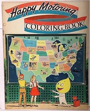
Happy Motoring Coloring Book
Published by General Drafting Company, Convent Station, NJ, 1963
First Edition
Paperback. Condition: Good Minus. First Edition. 24pp. Pages are toning. Wraps have edgewear. Front wrap has light foxing along the spine edge. Wraps have small damp stains along the edges. Wraps have scuffs and light scratches. Front wrap has tiny surface tears. Text is unmarked. First Edition. Paperback. Good Minus.
-
![Seller image for Of maps and mapping (1959) [Leatherbound] for sale by S N Books World](https://pictures.abebooks.com/inventory/md/md30863607877.jpg)
Leatherbound. Condition: NEW. Leatherbound edition. Condition: New. Leather Binding on Spine and Corners with Golden leaf printing on spine. Bound in genuine leather with Satin ribbon page markers and Spine with raised gilt bands. A perfect gift for your loved ones. Reprinted from 1959 edition. NO changes have been made to the original text. This is NOT a retyped or an ocr'd reprint. Illustrations, Index, if any, are included in black and white. Each page is checked manually before printing. As this print on demand book is reprinted from a very old book, there could be some missing or flawed pages, but we always try to make the book as complete as possible. Fold-outs, if any, are not part of the book. If the original book was published in multiple volumes then this reprint is of only one volume, not the whole set. IF YOU WISH TO ORDER PARTICULAR VOLUME OR ALL THE VOLUMES YOU CAN CONTACT US. Resized as per current standards. Sewing binding for longer life, where the book block is actually sewn (smythe sewn/section sewn) with thread before binding which results in a more durable type of binding. Pages: 64 Language: English Pages: 64.
-
![Seller image for Markets of the world; a series of economic maps & statistical abstracts of the principal countries of the world . comp. by General drafting co., inc. (1920) [Leatherbound] for sale by S N Books World](https://pictures.abebooks.com/inventory/md/md31376382995.jpg)
LeatherBound. Condition: New. Leatherbound edition. Condition: New. Leather Binding on Spine and Corners with Golden leaf printing on spine. Bound in genuine leather with Satin ribbon page markers and Spine with raised gilt bands. A perfect gift for your loved ones. Reprinted from 1920 edition. NO changes have been made to the original text. This is NOT a retyped or an ocr'd reprint. Illustrations, Index, if any, are included in black and white. Each page is checked manually before printing. As this print on demand book is reprinted from a very old book, there could be some missing or flawed pages, but we always try to make the book as complete as possible. Fold-outs, if any, are not part of the book. If the original book was published in multiple volumes then this reprint is of only one volume, not the whole set. IF YOU WISH TO ORDER PARTICULAR VOLUME OR ALL THE VOLUMES YOU CAN CONTACT US. Resized as per current standards. Sewing binding for longer life, where the book block is actually sewn (smythe sewn/section sewn) with thread before binding which results in a more durable type of binding. Pages: 58 Language: English Pages: 58.
-
![Seller image for Markets of the world, United States & Canada series; a compilation of commercial maps & statistical data. Prepared and published by the First National Bank of Boston (1922) [Leatherbound] for sale by S N Books World](https://pictures.abebooks.com/inventory/md/md30638764206.jpg)
Leatherbound. Condition: NEW. Leatherbound edition. Condition: New. Leather Binding on Spine and Corners with Golden leaf printing on spine. Bound in genuine leather with Satin ribbon page markers and Spine with raised gilt bands. A perfect gift for your loved ones. Reprinted from 1922 edition. NO changes have been made to the original text. This is NOT a retyped or an ocr'd reprint. Illustrations, Index, if any, are included in black and white. Each page is checked manually before printing. As this print on demand book is reprinted from a very old book, there could be some missing or flawed pages, but we always try to make the book as complete as possible. Fold-outs, if any, are not part of the book. If the original book was published in multiple volumes then this reprint is of only one volume, not the whole set. IF YOU WISH TO ORDER PARTICULAR VOLUME OR ALL THE VOLUMES YOU CAN CONTACT US. Resized as per current standards. Sewing binding for longer life, where the book block is actually sewn (smythe sewn/section sewn) with thread before binding which results in a more durable type of binding. Pages: 82 Language: English Pages: 82.
-
![Seller image for Markets of the world. : A series of economic maps & statistical abstracts of the principal countries of the world. / Compiled and published by the First National Bank of Boston, Mass., U.S.A (1920) [Leatherbound] for sale by S N Books World](https://pictures.abebooks.com/inventory/md/md30638766926.jpg)
Leatherbound. Condition: NEW. Leatherbound edition. Condition: New. Leather Binding on Spine and Corners with Golden leaf printing on spine. Bound in genuine leather with Satin ribbon page markers and Spine with raised gilt bands. A perfect gift for your loved ones. Reprinted from 1920 edition. NO changes have been made to the original text. This is NOT a retyped or an ocr'd reprint. Illustrations, Index, if any, are included in black and white. Each page is checked manually before printing. As this print on demand book is reprinted from a very old book, there could be some missing or flawed pages, but we always try to make the book as complete as possible. Fold-outs, if any, are not part of the book. If the original book was published in multiple volumes then this reprint is of only one volume, not the whole set. IF YOU WISH TO ORDER PARTICULAR VOLUME OR ALL THE VOLUMES YOU CAN CONTACT US. Resized as per current standards. Sewing binding for longer life, where the book block is actually sewn (smythe sewn/section sewn) with thread before binding which results in a more durable type of binding. Pages: 146 Language: English Pages: 146.
-

Map of Colonial Williamsburg, Williamsburg, Virginia.
Published by Williamsburg, Va.: Colonial Williamsburg Foundation, ca. 1960s., 1960
Manuscript / Paper Collectible
Condition: Good. Folded color map measuring 18 x 24 inches, with index to buildings and sites of interest. Very good, suitable for framing.
-
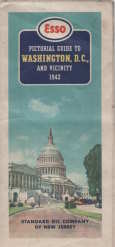
ESSO pictorial guide of Washington, D.C., and vicinity : our nation's capital
Published by Standard Oil Co., New York?, 1942
Map
No Binding. Condition: Very Good. folding map,2 maps on 1 sheet : both sides, color ; 47 x 63 cm and 47 x 41 cm, sheet 50 x 66 cm, folded to 25 x 11 cm separation at 2 folds, some over all soil, Esso pictorial map of Washington, our nation's capital Happy motoring in Washington and vicinity Selected buildings shown pictorially on city map Panel title "Copyright, General Drafting Co., Inc." Includes text, indexes to points of interest, Alexandria inset, sector diagram, col. ill., and advertisement POSTAGE WILL BE REDUCED.
-
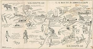
U.S. Route 20 The Shortest Route 155 Miles U.S. Route 20 - Today's New York State Scenic Byway
Published by c. 1930, 1930
Seller: Curtis Wright Maps, Berwyn, IL, U.S.A.
Seller Rating:

Condition: Very Good. "This interesting double-sided road map was published by the U.S. Route 20 Association of Waterville, New York to promote the motor route between Albany and Auburn, near Syracuse. Maps created by the General Drafting Company highlight the highway in red, with distances between points noted and insets in the lower corners showing city plans of each endpoint. The verso presents a pictorial map designed by Osborne Mayer (also of Waterville) that highlights the deep history of the region. Source." Sheet Width (in) 15.9 Sheet Height (in) 8.8 Condition Description Heavy soiling visible throughout, most evident on the left side of the map. Creasing along fold lines and small edge tears. Fair condition overall.
-
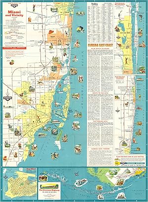
Miami and Vicinity Road map of Miami issued by Standard Oil in 1958.
Publication Date: 1958
Seller: Curtis Wright Maps, Berwyn, IL, U.S.A.
Seller Rating:
Condition: Fine. Although federal legislation to construct the Interstate Highway System had been passed under Dwight D. Eisenhower in 1956, this map of the area around Miami only labels numbered highways and state route numbers. U.S. Highway 1, seen here connecting Ft. Lauderdale to Miami, would eventually become part of the nation's longest interstate - I-95. In addition to showing road information, the map also lists locations of interest and summarizes the high points of various towns and cities. Insets of Key West, the Overseas Highway, Palm Beach and Florida's East Coast complete the view. A small scale map of Miami and Miami Beach is available on the verso. Sheet Width (in) 18.5 Sheet Height (in) 25 Condition Description Fold lines as issued, otherwise excellent.
-
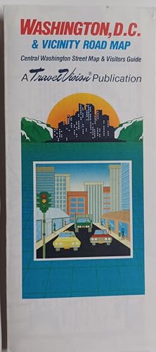
Washington, D.C., map and visitors guide
Published by General Drafting Co, 1988
ISBN 10: 1557600295ISBN 13: 9781557600295
Book
Condition: Good. No Highlighting or writing. Some Wear but overall good condition. 100% Satisfaction Guaranteed.
-
Principal Highway Routes of the United States
Published by General Drafting Co. Inc, New York, 1933
Folding highway map of the US which includes inset map of "Washington, New York-Boston Section." Mileage table, text on the National Parks and the Transcontinental Tour, time zone map, and pictorial relief map on verso. Worldcat lists the date for this publication as 1931, but in the section on National Parks, the "new Trans-Mountain Highway," of Glacier National Park is mentioned, which was completed in 1933. An uncommon map. Folding map, 40x67cm, folded to 18x11cm. Good condition with toning, wear to folds, and a split to fold at bottom left panel. Former owner's annotations in pencil on both sides, with route from San Francisco to Providence traced neatly in green.
-
Full Cloth. Condition: Very Good. No Jacket. First Edition. FIRST EDITION, first printing. Original full blue cloth hardcover. Comes with business card of the manager of Gerneral Drafting Co and a sheet describing the book. No previous owner's names, not exlibrary. Overall in VERY GOOD condition. Size: 4to - over 9�" - 12" tall. Hardcover.
-

Map of the Principal Events in the Life of George Washington contributed to the Bicentennial Celebration of his birth by the
Published by GENERAL DRAFTING CO, NY, 1960
PAPER BACK. Condition: GOOD. CIRCA 1950 title cont. Standard Oil Company of New Jersey DATE PUBLISHED: 1960 EDITION:
-
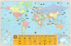
VFW Campaign Map of the World American troops overseas since World War I.
Publication Date: 1987
Seller: Curtis Wright Maps, Berwyn, IL, U.S.A.
Seller Rating:
Condition: Fine. This commemorative map of the world highlights the various overseas actions of the United States military forces, beginning with World War I. Various ribbons recognizing service in each campaign are shown and described along the bottom of the sheet. Inset maps in bother lower corners show the polar regions, though fortunately, both are lacking in serious military action. Text on the verso explains VFW eligibility and member benefits. Published in Convent Station, New Jersey by the General Drafting Company on behalf of the Veterans of Foreign Wars (VFW). Sheet Width (in) 35.5 Sheet Height (in) 22.75 Condition Description Moderate wear and creasing along originally issued fold lines, including holes at fold intersections and a few small edge tears that have been repaired on the verso with archival tape. A bit of extraneous wrinkling also visible within the image, but overall remains in very good condition.
-
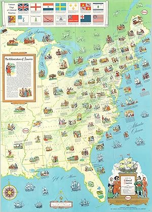
Life in Colonial America Pictorial map issued in conjunction with the 1957 Jamestown Festival in Virginia.
Publication Date: 1957
Seller: Curtis Wright Maps, Berwyn, IL, U.S.A.
Seller Rating:
Condition: Fine. "The "Jamestown Festival" took place over an eighth month period in Virginia during 1957, to celebrate the 350th anniversary of the settlement's founding. This pictorial map was issued to commemorate the event and provides a historical overview of life in colonial America between the original landing at Jamestown and the Revolution. Numerous vignettes accompanied by succinct captions highlight many of the important places, people, and events that led to the formation of the United States in the late 18th century. The various flags of colonial America can be seen at the top of the sheet, while a brief paragraph provides a whitewashed summary of the events that led to the conquest of the continent. The verso shows vivid reproductions of several early important maps of America, including John Smith's map of Virginia, John White's map of North Carolina, and surveys of New York, Philadelphia, Boston, and New Orleans. Published in 1957 by the General Drafting Company on behalf of Esso Oil." Sheet Width (in) 23.9 Sheet Height (in) 33.4 Condition Description Creasing along originally issued fold lines, but otherwise in near fine condition.
-
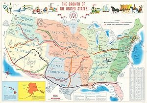
The Growth of the United States General Drafting Company's map celebrating America's bicentennial.
Publication Date: 1976
Seller: Curtis Wright Maps, Berwyn, IL, U.S.A.
Seller Rating:
Condition: Fine. This lovely map of the United States was issued by the General Drafting Company in 1976 to celebrate America's 200th birthday. The image presents the growth of the United States as an iterative process that began with the Revolution and culminated with the annexation of Hawaii and the U.S. Overseas Territories. Bright colors highlight each major acquisition, with the major trails that facilitated Westward Expansion also colored and labeled. Small illustrations throughout the map and across the top reflect the historical development of the nation, especially in terms of its transportation system. The verso presents a pictorial map of America in colonial times, from the earliest European settlers to the outbreak of the Revolution. Sheet Width (in) 33.75 Sheet Height (in) 23.25 Condition Description Creasing along originally issued fold lines, otherwise in fine condition overall.
-
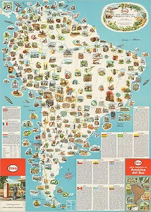
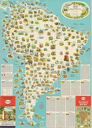
Mapa Panoramico de America Del Sur Mid-century road map of South America.
Published by c. 1955, 1955
Seller: Curtis Wright Maps, Berwyn, IL, U.S.A.
Seller Rating:
Condition: Fine. This Spanish-language map of South America was published around 1955 by the General Drafting Company to promote ESSO oil products and encourage motor tourism across the continent. One side presents a beautiful pictorial map that completely omits national borders. Dozens of vibrantly illustrated vignettes highlight South America's myriad of attractions, historic sites, natural features, and recreational opportunities. A brief description of each country is accompanied by an image of its flag. The verso is a more traditional road map of the continent, with an index of cities and towns and an inset physical map. Sheet Width (in) 24 Sheet Height (in) 33.5 Condition Description Creasing and minor wear along originally issued fold lines, including some light wrinkling and tiny tears along the outer edges of the sheet. Very good to near fine overall.
-

Pictorial Map of Alaska Pictorial celebration of Alaska's statehood.
Publication Date: 1959
Seller: Curtis Wright Maps, Berwyn, IL, U.S.A.
Seller Rating:
Condition: Fine. "This wonderful pictorial map was issued by the General Drafting Company in 1959 to welcome the 49th of the United States of America. The industries, cultural heritage, and transportation network of Alaska are highlighted with various pictorial icons and colored illustrations. Two inset maps are present. The first (upper right) shows the strategic geographic situation secured with Alaska's statehood, including its connection to the U.S. Interstate System via the Alaska Highway. The second inset (lower center) shows the Aleutian Island chain. The verso features extensive text outlining further the region's history, agriculture, geography, and commercial opportunities. It also presents advertisements for Westinghouse appliances and characters from the popular show 'I Love Lucy." Sheet Width (in) 20 Sheet Height (in) 16.75 Condition Description Faint creasing along originally issued fold lines and faint wear along the outer edges of the sheet. Very good to fine condition overall.
-
Mapa Panoramico de America del Sur Double sided map of South America from the mid-20th century.
Publication Date: 1953
Seller: Curtis Wright Maps, Berwyn, IL, U.S.A.
Seller Rating:
Condition: Fine. This eye-catching map of South America was published in New Jersey by the General Drafting Company on behalf of Esso Oil. One side presents a stunning pictorial depiction of the continent, highlighting primary industrial exports, agricultural products, historic sites, recreational opportunities, and more. Accompanying text (in Spanish) describes the various countries in some detail. The verso presents a transportation outline of South America as well as a physical map of the continent. The map is emblematic of ongoing efforts by American multi-national corporations to extend operations into foreign markets during the 20th century. Sheet Width (in) 23.75 Sheet Height (in) 33.5 Condition Description Light creasing and faint wear along fold lines, as issued.
-
Souvenir Map of the Pennsylvania Turnpike Pictorial map of the Pennsylvania Turnpike issued the year after the road first opened.
Publication Date: 1941
Seller: Curtis Wright Maps, Berwyn, IL, U.S.A.
Seller Rating:
Condition: Fine. Though it would ultimately extend across the entire breadth of the state, what you're seeing here is the first section of the newly constructed Pennsylvania Turnpike - approximately 160 of the 360 completed miles. Opened between Carlisle and Irwin on Oct. 1, 1940, the route (highlighted in red) is billed as 'America's Greatest Highway' on this promotional brochure by General Drafting Company. Pictorial illustrations highlight many of the local attractions along the toll road as well as the numerous tunnels and bridges necessary to traverse the mountainous terrain. Service stations are also noted, allowing the motorist to stay refreshed without a long detour. An inset in the lower right shows a typical traffic interchange, with the toll booth located on entry/exit ramp. Sheet Width (in) 32.9 Sheet Height (in) 8 Condition Description Originally issued folded into six panels, with faint wear and light creasing along fold lines. Includes a original mailing envelope, slightly soiled.
-
Atlantic Road Map Pennsylvania - Delaware [Title on Verso] "THERE IS AN ATLANTIC PUMP ON THE ROAD YOU ARE TRAVELING"
Publication Date: 1927
Seller: Curtis Wright Maps, Berwyn, IL, U.S.A.
Seller Rating:
Condition: Very Good. This promotional road map covering the states of Delaware and Pennsylvania was published by the Atlantic Refining Company of Philadelphia and Pittsburgh in 1927. Atlantic was one of the 34 companies established as a result of Standard Oil's Supreme Court-mandated dissolution in 1911 and would eventually merge with Richfield Oil to become ARCO. Four different maps across the recto and verso were designed by the General Drafting Companies and show 1. Road Map of Pennsylvania, 2. Southeastern Pennsylvania, Delaware, and Routes to New York, Atlantic City, N.J. and Washington, D.C., and city plans of 3. Philadelphia and 4. Pittsburgh. Advertisements for Atlantic Motor Oil and a list of mileage tables are also present. Sheet Width (in) 26.1 Sheet Height (in) 16.75 Condition Description Moderate wear and discoloration along fold lines, especially on the front panels and vertical centerfold. Small spots of paper loss at fold intersections and minor tears visible along the outer edges of the sheet. Good condition overall.
-
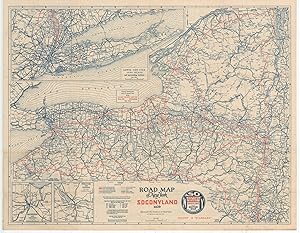
Road Map of New York in Soconyland 1926 New York's road network during the Roaring 20's.
Publication Date: 1926
Seller: Curtis Wright Maps, Berwyn, IL, U.S.A.
Seller Rating:
Condition: Fine. This detailed road map of New York state was created and published by General Drafting Company, Inc. on behalf of the Standard Oil Company of New York (Socony) in 1926. Socony (today's Mobil Corporation) was established in 1911 as one of the 34 smaller companies created by the dissolution of Standard Oil due to its monopolistic practices in the industry. Primary, first, and second-class roads are highlighted in solid and hollow orange lines, respectively, while other transportation routes are noted according to the legend in the lower center. Distances between points are noted, providing a useful aid for travelers. Inset maps on the recto and verso show Long Island, New York City, Rochester, Syracuse, Buffalo, Albany, Troy, and Utica. 'Common Sense Rules of the Road' and a comprehensive index of towns and cities are also provided on the verso. Sheet Width (in) 27.8 Sheet Height (in) 21.7 Condition Description Creasing along originally issued fold lines and some minor wear and soiling visible in the outer margins of the sheet. Very good overall.
-
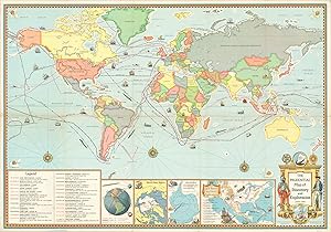
The Prudential Map of Discovery and Exploration Global summary of nearly a millennium of human exploration.
Publication Date: 1961
Seller: Curtis Wright Maps, Berwyn, IL, U.S.A.
Seller Rating:
Condition: Very Good. "This vibrant world map on Mercator's projection highlights the routes of twenty-five adventures of exploration and discovery across the globe. Heroic feats from Leif Ericsson's first landfall in Greenland in 1000 to Roald Amundsen's all-water transit of the Northwest Passage in 1906 are commemorated according to the legend in the lower left. Three inset maps along the bottom show further explorations across both poles and throughout North America. A fourth inset map, as well as several of the more recent 'explorers' routes, reflects the ongoing tension between the Soviet Union and United States. The orbits of Sputnik, Explorer I, and Echo I highlight how the U.S. has recently (temporarily) surpassed the U.S.S.R. in the Space Race, while the route of the Lucky Lady (1949) and Triton (1960) within the main image showcase U.S. military technology during the Cold War. The map was published in 1961 by General Drafting Company on behalf of Prudential Insurance. What does insurance have to do with exploration, you ask? An advertisement on the verso provides a loose connection by suggesting "most men chart a secure course for their families' future." Sheet Width (in) 36 Sheet Height (in) 24.9 Condition Description "Originally issued folded into 10 panels, with moderate wear and creasing along fold lines. Separation along the horizontal crease, including a 3" tear on the far left side (repaired on verso).".
-
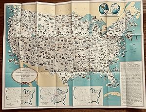
31 1/4 x 23 1/4 inches. Condition: Very good. Handsomely positioned and designed map. There are small illustrations that hit the high point of a states attractiveness to the user. The map was designed for classroom use. It was distributed out of NYC. Chicago was noted for having 33 trunk line railroads. Notre Dame made the area for Indiana. Isotopes was illustrated for Oak ridge, TN. The verso has map of the United States for trip planning. It shows highways. This is an attractive map and its pictorial attributes make it useful for a kids common area.
-

A Pictorial Map of the United States A visual representation of American postwar prosperity.
Published by c. 1955, 1955
Seller: Curtis Wright Maps, Berwyn, IL, U.S.A.
Seller Rating:
Condition: Fine. Designed by the General Drafting Company and published by the Esso (S-O, a company created from the dissolution of Standard Oil) Oil Company in the mid 1950's, this pictorial map highlights the industrial, agricultural, and recreational bounty of the postwar United States. Small, charming illustrations showing all that America has to offer can be found in every state and along every coast. Emphasis and priority is given to regional exports and local financial engines like manufacturing, produce, etc., but numerous prominent landmarks are also featured; blurring the distinction between cultural identity and economic development. Three insets at the bottom of the sheet show oil production, refineries and pipelines across the United States. According to text on the verso, the map was designed to be hung in a classroom and was distributed freely simply by inquiring with Esso's marketing department. By broadly circulating material such as this, a global oil company was able to successfully associate their financial success with the economic well-being of an entire nation! Sheet Width (in) 35.9 Sheet Height (in) 23.9 Condition Description Originally folded into a 24 panel brochure. Creasing along original fold lines and a few pinholes in the outer margins from where the map was previously hung. Otherwise in excellent condition.
-
[ESSO War Maps] Esso's (Standard Oil, 'S' - 'O') three maps covering the Second World War.
Published by 1942 - 1944, 1942
Seller: Curtis Wright Maps, Berwyn, IL, U.S.A.
Seller Rating:
Condition: Very Good. "This group of three maps was published by the General Drafting Company of New Jersey on behalf of the Esso Oil Corporation. Brief descriptions of each follow: Esso War Map Featuring Transportation - The focus of this Esso War Map (one of three published by the oil company during the war) is on global transportation. The main map presents the world on the Miller Cylindrical Projection and emphasizes distances by sea. A smaller inset map, using a North Polar projection, shows a different perspective and stresses the length between various points by air. The verso presents a host of Esso related propaganda about how oil is directly related to the war effort. "Fuel for Speed and Power," "War-Time Lubricants," "Rubber from Oil" and more! An interesting piece of wartime promotion that shows one way some Americans would have consumed information about the ongoing conflict overseas. Esso War Map II Featuring the World Island - The primary image shows the Eastern Hemisphere between the Atlantic and Pacific Oceans. A standard political map with supplemental war information. The verso includes a more detailed picture of the European and North African theaters, with accompanying text detailing 'The Geography of Global Warfare.' Esso War Map III Featuring the Pacific Theater - This is an incredibly detailed overview of the Pacific Theater, showing infrastructure, topography, place names and more. Japan, the Philippines and numerous insets are presented on one side, while a small scale map of the entire theater is on the other. Individually numbered locations correspond to the separately published Esso War News, making the overall piece a formidable source of wartime intelligence for the armchair generals at home." Sheet Width (in) 32.75 Sheet Height (in) 22.5 Condition Description "Three folding maps, each measuring approximately 32.75" x 22.5", with creasing and moderate wear along fold lines. One hole in Map No. II, and several areas of separation and tearing along fold lines on the other sheets. Each remains in good condition overall.".
-
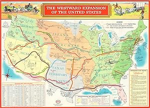
The Westward Expansion of the United States Rosy overview of the American conquest of much of North America.
Publication Date: 1958
Seller: Curtis Wright Maps, Berwyn, IL, U.S.A.
Seller Rating:
Condition: Fine. This colorful overview of the United States highlights the gradual development of the modern day conception of America and its overseas possessions. Various stages of the country's development are shown in different shades, with little mention of the inevitable conflict resulting from the growth. Major early trails and roads are also colored and labeled, linking America's expansion and apparently inevitable success with its system of transportation. The attempted association is unsurprising, given the image was produced and distributed by General Drafting Company, a division of the Esso Oil Company and strong proponent of the growing Interstate Highway System. The verso of the image features an attractive pictorial map of early colonial America, with numerous illustrated vignettes showing important historical events east of the Mississippi River. Accompanying the map is a list of Famous Flags of Colonial America and a brief Euro-centric history of the early colonization of the continent. Sheet Width (in) 33.5 Sheet Height (in) 23.9 Condition Description Originally folded into 20 panels, with faint creasing along fold lines. Otherwise in fine condition.
-
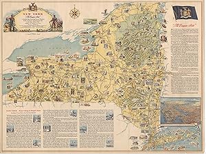
New York "The Empire State" "Postwar pictorial celebration of "The Empire State"
Published by c. 1946, 1946
Seller: Curtis Wright Maps, Berwyn, IL, U.S.A.
Seller Rating:
Condition: Very Good. "This attractive pictorial map of New York was designed by the General Drafting Company and published in Albany by the New York State Department of Commerce in 1946. With the horrors of World War II in the rearview, the map leverages the New York's relatively short (Western) history to highlight its incredible rise to the status of "Empire State." Illustrated vignettes show prominent figures, historic sites, recreational opportunities, industrial products, and notable events. A brief essay in the lower left, written by Dr. Albert B. Corey, provides a timeline of New York history from Henry Hudson into the 1940s, though there is no reference to either WWI or WWII. Additional text in the upper right presents contemporary statistics and facts that would have been very persuasive to individuals and businesses looking to relocate in the postwar years. Source: Rumsey 8987.000" Sheet Width (in) 39.25 Sheet Height (in) 29.5 Condition Description Moderate wear and creasing along former fold lines. Moderate wear along the outer edges of the sheet, most evident in the lower right with a few small tears and chips in the paper. One damp stain in the center-right, just to the left of the NEW YORK STATE INSIGNIA text. Between good and very good overall.
-
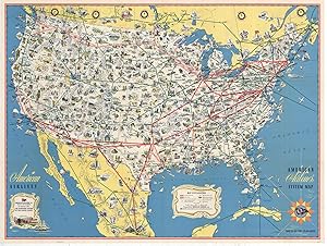
American Airlines System Map Route of the Flagships Vibrant map of the United States highlighting the domestic airlines in operation during the early 1950's.
Published by c. 1950, 1950
Seller: Curtis Wright Maps, Berwyn, IL, U.S.A.
Seller Rating:
Condition: Fine. Published near the beginning of air travel's ascendancy (overtaking rail), this pictorial map outlines the flight routes available to travelers in the United States, Canada, and Mexico shortly after the end of WWII. Routes operated by American and other companies are shown, as this was a time when regional airlines still dominated a large section of the market. The workhorse of the fleet, the DC-3, is shown on the cover and revolutionized consumer air travel in the United States. However, a coast-to-coast flight would still require several refueling stops and take as long as 20 hours! Small illustrations highlight many of the natural attractions, historic sites, and important landmarks accessible by air across the country, and strip maps on the verso provide further information on twelve of the most popular routes across the country. Sheet Width (in) 31.75 Sheet Height (in) 23.75 Condition Description Very light wear and creasing along originally issued fold lines. Near fine condition overall.


![Seller image for Atlantic Road Map Pennsylvania - Delaware [Title on Verso] "THERE IS AN ATLANTIC PUMP ON THE ROAD YOU ARE TRAVELING" for sale by Curtis Wright Maps](https://pictures.abebooks.com/inventory/md/md31695373546.jpg)
![Seller image for [ESSO War Maps] Esso's (Standard Oil, 'S' - 'O') three maps covering the Second World War. for sale by Curtis Wright Maps](https://pictures.abebooks.com/inventory/md/md31695375312.jpg)