Order Total (1 Item Items):
Shipping Destination:

Germany Map (42 results)
Skip to main search results
Product Type
- All Product Types
- Books (40)
- Magazines & Periodicals (1)
- Comics
- Sheet Music
- Art, Prints & Posters
- Photographs
- Maps (1)
-
Manuscripts &
Paper Collectibles
Condition
- All Conditions
- New
- Used
Binding
Collectible Attributes
- First Edition (4)
- Signed (1)
- Dust Jacket (1)
- Seller-Supplied Images (10)
- Not Printed On Demand
Seller Location
Seller Rating
-

Geologische Ubersichtskarte von Hessen.
Published by Bodensforschung Wiesbaden 1952, Wiesbaden, 1952
Folded Map (illustrator). Very good condition.
-

The National Geographic Magazine. June, 1959 / Robert Leslie Conly and Erich Lessing "Modern Miracle, made in Germany" / Paul A Zahl "Volcanic Fires of the 50th state: Hawaii National Park" / Phyllis Wilson and Kathleen Revis " Queen of Canada" / Geographic photographers win top awards / John T Cunningham, Jay Johnston and W D Vaughn "Staten Island ferry, New York's seagoing bus" / Nathaniel T Kenney and William Belknap Jr "Where falcons wear Air Force blue" / New atlas map charts a Germany divided.
Published by The National Geographic Society, 1959
Magazine / Periodical
Soft cover. Condition: Good. Robert Leslie Conly and Erich Lessing "Modern Miracle, made in Germany" / Paul A Zahl "Volcanic Fires of the 50th state: Hawaii National Park" / Phyllis Wilson and Kathleen Revis " Queen of Canada" / Geographic photographers win top awards / John T Cunningham, Jay Johnston and W D Vaughn "Staten Island ferry, New York's seagoing bus" / Nathaniel T Kenney and William Belknap Jr "Where falcons wear Air Force blue" / New atlas map charts a Germany divided.
-
![Seller image for Berlin; Kleine Ausgabe [= Small Edition] for sale by Evening Star Books, ABAA/ILAB](https://pictures.abebooks.com/inventory/md/md31516503556.jpg)
Berlin; Kleine Ausgabe [= Small Edition]
Published by Albert Goldschmidt, Berlin, 1913
Seller: Evening Star Books, ABAA/ILAB, Madison, WI, U.S.A.
Association Member: ABAA ILAB IOBA
Seller Rating:

Pamphlet. Condition: Good. Reprint. 12mo. 36.5 c.m. x 24 c.m. [2] (pages of publisher's advertisements), [3], 4-114, [2], [4] (pages of publisher's advertisements) pp. Light brown wraps printed in blue. Price of 1 Mark on the front wrapper. Illustrated with four maps (three folding). With excerpts from the 57th edition. Book 25 in a series of travel guides. Lacks the final map (torn away), a name on the front wrapper.
-
THE ECONOMIC DEVELOPMENT OF FRANCE AND GERMANY 1815-1914
Published by Cambridge University Press, 1945
First Edition Signed
Hard Cover. Condition: Good +. Dust Jacket Condition: Poor. Maps of France and Germany inside back cover ( Very Good Condition ) (illustrator). Fourth Edition. Dust jacket large pieces missing approx 1/3rd of top of spine, unclipped. Light green boards with gilt on spine. Maps of France and Germany inside back cover (good condition). Inside pages clean and unmarked. Purchased from the Estate of Christopher Dobson Grandson of Austin Dobson. Written in pencil on front paste down by Dobson, "collection Christopher Dobson. see p. 60." In pencil on page 60 is written in the margin, "But Harry Dobson anticipated this by at least 16 years." Size: 8vo. Inscribed By Christopher Dobson.
-
(POCKET MAP) GERMANY, AUSTRIA & SWITZERLAND, WITH BOUNDARIES, ROADS AND RAILWAYS [SOUTHERN SHEET]
Published by Edinburgh Geographical Institute/John Bartholomew & Son Ltd, Edinburgh, 1957
Pamphlet. Condition: Very Good. Lge Color FoldOut Map (26 X 41 Inches), Folds to 5 X 8.5 Inches, Grey Illus Paper Covers, (Nice Pastel Color, with Focus on Alps) (Scale 1:1,000,000), VG.
-
Map, Germany - 19th Century
Publication Date: 1880
Seller: K Books Ltd ABA ILAB, York, YORKS, United Kingdom
Association Member: ABA ILAB PBFA
Seller Rating:
Book
No Binding. Condition: Very Good. An antique map, very good condition. Mounted - matted - and ready to frame. Mount size approx 12 x 10 inches, 36 x 30 cms. Original contemporary colouring. Circa 1880. Very detailed - Shows - Germany and coloured - attractive and reasonably priced - quite detailed.
-
GERMANY: INDUSTRIES & COMMUNICATIONS - an Original Coloured Map, Printed C1908
Published by George Philip & Son/The London Geographical Institute, London, 1908
Seller: K Books Ltd ABA ILAB, York, YORKS, United Kingdom
Association Member: ABA ILAB PBFA
Seller Rating:
Book
No Binding. Condition: Very Good. An original map, printed in full colour, central fold. A map of Germany, including parts of the surrounding countries, showing railways, canals, steamship routes, cables, British and American Consuls, and the main products of all the areas including flax, coal, china, pianos, lignite, salt, wine , tobacco, pencils, zinc etc.
-
EASTERN GERMANY - an Original Coloured Map, Printed C1908
Published by George Philip & Son/The London Geographical Institute, London, 1908
Seller: K Books Ltd ABA ILAB, York, YORKS, United Kingdom
Association Member: ABA ILAB PBFA
Seller Rating:
Book
No Binding. Condition: Very Good. An original map, printed in full colour, central fold. A map of Eastern Germany, with insets showing German Possessions, the Rhine, Hamburg and the Environs of Berlin.
-
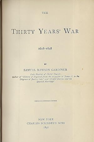
THE THIRTY YEARS' WAR 1618-1648
Published by Charles Scribner's Sons, NY, 1891
Seller: Antic Hay Books, Asbury Park, NJ, U.S.A.
Seller Rating:
Large Fold-Out Color Map Of Germany (illustrator). Later Edition. Very Good (covers nice & bright; contents clean & tight, pencil name on front blank page). 12mo., embossed brown cloth, stamped in black & gilt; 237 pages, plus catalogue.
-
Map of Germany - an Original Engraving
Seller: K Books Ltd ABA ILAB, York, YORKS, United Kingdom
Association Member: ABA ILAB PBFA
Seller Rating:
Book
No Binding. Condition: Very Good. A fine Engraving - printed circa 1870. Mounted and ready to frame. A fine opportunity to purchase an attractive and decorative engraved Map of Germany.
-
Antique Map - Ancient Germany
Published by Stanford, London, 1857
Seller: K Books Ltd ABA ILAB, York, YORKS, United Kingdom
Association Member: ABA ILAB PBFA
Seller Rating:
Book First Edition
No Binding. Condition: Very Good. First Edition. An antique coloured map- colouring contemporary but expertly and delicately executed - very good condition . Mounted - matted - and ready to frame . . Shows Ancient Germany - very detailed - - very attractive and in excellent condition.
-
Germany, Northern Part - Antiquarian Coloured Map
Published by H.G.Collins, London
Seller: K Books Ltd ABA ILAB, York, YORKS, United Kingdom
Association Member: ABA ILAB PBFA
Seller Rating:
Book
No Binding. Condition: Very Good. An original antique map of Northern Germany. Mounted and ready to frame. Contemporary Colouring in outline. In excellent condition, decorative and impressive.
-
Germany, Southern Part - Antiquarian Coloured Map
Published by H.G.Collins, London
Seller: K Books Ltd ABA ILAB, York, YORKS, United Kingdom
Association Member: ABA ILAB PBFA
Seller Rating:
Book
No Binding. Condition: Very Good. An original antique map of Southern Germany, ca. 1860. Mounted and ready to frame. Contemporary Colouring in outline. In excellent condition, decorative and impressive.
-
Plan of Ehrenbreitstein - German Fortress on the River Moselle - an Original Antique Engraving
Published by Luffman, 1800
Seller: K Books Ltd ABA ILAB, York, YORKS, United Kingdom
Association Member: ABA ILAB PBFA
Seller Rating:
Book
No Binding. Condition: Very Good. An original hand-coloured antique engraved map, printed circa 1800. Hand-colouring contemporary. Mounted/matted and ready to frame. A fine opportunity to purchase an attractive and decorative engraving of a plan of Ehrenbreitstein - German Fortress on the River Moselle.
-
GERMANY MAP. An Original Hand-Coloured Engraved Map.
Published by BRIGHTLY & KENNEDY, Bungay, Suffolk, 1807
Seller: K Books Ltd ABA ILAB, York, YORKS, United Kingdom
Association Member: ABA ILAB PBFA
Seller Rating:
Book
No Binding. Condition: Very Good. Barlow (illustrator). An original, hand-coloured engraved map; colouring not contemporary, but delicately and expertly done. Will come mounted (matted) and ready to frame - mount size 13 x 11 inches. An opportunity to buy a decorative and attractive antique map of Germany.
-
Map of Germany - Fine Detailed Map - an Original Engraving
Publication Date: 1850
Seller: K Books Ltd ABA ILAB, York, YORKS, United Kingdom
Association Member: ABA ILAB PBFA
Seller Rating:
Book
No Binding. Condition: Very Good. A fine engraving - printed circa 1850. Mounted and ready to frame. Hand colouring not contemporary, but delicately and expertly executed. A fine opportunity to purchase an attractive and decorative engraving - Map of Germany.
-
Germany - Eastern Part of the Prussian States - an Antique Map
Seller: K Books Ltd ABA ILAB, York, YORKS, United Kingdom
Association Member: ABA ILAB PBFA
Seller Rating:
Book
No Binding. Condition: Very Good. Engraved By Walker (illustrator). A fine antique map in very good condition - printed in circa 1844. Mounted (matted) and ready to frame. Engraved size approx 16 x 13 Ins, 41 x 33 Cms. Mounted size approx 19 x 16 in, 49 x 41cm. Coloured in outline, hand colouring contemporary. A fine engraved map of Germany - Eastern Part of the Prussian States.
-
Germany - Attractive - Antiquarian Coloured Map
Publication Date: 1807
Seller: K Books Ltd ABA ILAB, York, YORKS, United Kingdom
Association Member: ABA ILAB PBFA
Seller Rating:
Book
No Binding. Condition: Very Good. An original antique map. Mounted and ready to frame. Hand coloured. In excellent condition, decorative and impressive.
-
Germany, Germania Antiqua - Antique Map, Contemporary Colouring 1798
Published by R Wilkinson, London, 1798
Seller: K Books Ltd ABA ILAB, York, YORKS, United Kingdom
Association Member: ABA ILAB PBFA
Seller Rating:
Book
No Binding. Condition: Very Good. E Bourne (illustrator). A splendid original antique map of Germany. Contemporary colouring and in excellent condition. Mounted and ready to frame. Extremely decorative and printed in 1798. A most desirable map with much detail and splendid colouring.
-
Germany - Antique Map, Contemporary Colouring 1798
Published by R Wilkinson, London, 1801
Seller: K Books Ltd ABA ILAB, York, YORKS, United Kingdom
Association Member: ABA ILAB PBFA
Seller Rating:
Book
No Binding. Condition: Very Good. J Roper (illustrator). A splendid original antique map of the Germany. Contemporary coloring and in excellent condition. Mounted and ready to frame. Extremely decorative and printed in 1801. Detailed and attractive historic map of Germany "Vindelicia Rhaetia et Noricum Antiqua".
-
Germany & Central Europe - Antique Map, Contemporary Colouring 1798
Published by R Wilkinson, London, 1801
Seller: K Books Ltd ABA ILAB, York, YORKS, United Kingdom
Association Member: ABA ILAB PBFA
Seller Rating:
Book
No Binding. Condition: Very Good. J Roper (illustrator). A splendid original antique map of Germany & Central Europe. Contemporary coloring and in excellent condition. Mounted and ready to frame. Extremely decorative map of antiquity, printed in 1801. Detailed and attractive map entitled "Pannonia, Davia, Illyricum et Moesia".
-
Map of Germany - Fine Detailed Map - an Original Engraving
Publication Date: 1850
Seller: K Books Ltd ABA ILAB, York, YORKS, United Kingdom
Association Member: ABA ILAB PBFA
Seller Rating:
Book
No Binding. Condition: Very Good. A fine engraving - printed circa 1850. Mounted and ready to frame. Hand colouring not contemporary, but delicately and expertly executed. A fine opportunity to purchase an attractive and decorative engraving - Map of Germany.
-
Germany - Showing Hungary, Tyrol, Switzerland, Prussia Etc - an Antique Map
Seller: K Books Ltd ABA ILAB, York, YORKS, United Kingdom
Association Member: ABA ILAB PBFA
Seller Rating:
Book
No Binding. Condition: Very Good. Engraved By Walker (illustrator). A fine antique map in very good condition - printed in circa 1844. Mounted (matted) and ready to frame. Engraved size approx 16 x 13 Ins, 41 x 33 Cms. Mounted size approx 19 x 16 in, 49 x 41cm. Coloured in outline, hand colouring contemporary. A fine engraved map of Germany - Showing Hungary, Tyrol, Switzerland, Prussia Etc.
-
Germany - Showing holstein, Hanover, Meckenburg, and the Prussian States, Saxony Etc - an Antique Map
Seller: K Books Ltd ABA ILAB, York, YORKS, United Kingdom
Association Member: ABA ILAB PBFA
Seller Rating:
Book
No Binding. Condition: Very Good. Engraved By Walker (illustrator). A fine antique map in very good condition - printed in circa 1844. Mounted (matted) and ready to frame. Engraved size approx 16 x 13 Ins, 41 x 33 Cms. Mounted size approx 19 x 16 in, 49 x 41cm. Coloured in outline, hand colouring contemporary. A fine engraved map of Germany - Showing holstein, Hanover, Meckenburg, and the Prussian States, Saxony Etc.
-
Germany - Austrian Dominions - Bohemia, Moravia, austria, Styria , Croatia, Etc - an Antique Map
Seller: K Books Ltd ABA ILAB, York, YORKS, United Kingdom
Association Member: ABA ILAB PBFA
Seller Rating:
Book
No Binding. Condition: Very Good. Engraved By Walker (illustrator). A fine antique map in very good condition - printed in circa 1844. Mounted (matted) and ready to frame. Engraved size approx 16 x 13 Ins, 41 x 33 Cms. Mounted size approx 19 x 16 in, 49 x 41cm. Coloured in outline, hand colouring contemporary. A fine engraved map of Germany - Austrian Dominions - Bohemia, Moravia, austria, Styria , Croatia, Etc.
-
Germany - an Original Coloured Map Printed C. 1758
Seller: K Books Ltd ABA ILAB, York, YORKS, United Kingdom
Association Member: ABA ILAB PBFA
Seller Rating:
Book
No Binding. Condition: Very Good. An original antique coloured map of part of Germany, a plan of Zell, Saxony. Mounted and ready to frame . Very good condition . A splendid vintage map - decorative, attractive and somewhat uncommon. An impressive map with a great amount of detail with fine contemporary colouring.
-

Original Hand-Colored Gray's New Map of Spain and Portugal By Frank A. Gray (and) Map of Germany Austria and Switzerland
Published by O.W. Gray & Son, Philadelphia, PA, 1882
First Edition
Not Bound. Condition: Very Good. Map. One sheet, printed with 2 maps, from the 1882 O.W. Gray National Atlas, New York Edition: Gray's New Map of Spain and Portugal by Frank A. Gray, copyright date of 1878, with inset Environs of Madrid, Gibraltar, Environs of Lisbon (and) Germany Austria and Switzerland. With hand-coloring in pastel tones and red border outlining. Approx. 14 3/8" x 17 1/4" overall size; a little even toning to the paper; couple of small nicks at edges; tiny corner bend; in very good condition.
-
MAP OF GERMANY. Antique Map
Published by G ROLLOS, 1790
Seller: K Books Ltd ABA ILAB, York, YORKS, United Kingdom
Association Member: ABA ILAB PBFA
Seller Rating:
Book
No Binding. Condition: Very Good. Hand coloured, copperplate engraved map. It has a fine cartouche, A fold markas is always the case with maps of this size, otherwise a vg copy of an attractive decorative hand coloured antique map. Scarce. A splendid map, colouring not contemporary but delicately and expertly done. Decorative cartouche.
-
Germany and Central Europe . . a Fine Antique World Map Printed in 1809
Publication Date: 1809
Seller: K Books Ltd ABA ILAB, York, YORKS, United Kingdom
Association Member: ABA ILAB PBFA
Seller Rating:
Book
No Binding. Condition: Very Good. A splendid large coloured map of Central Europe in Classical Times . Germany to Russia and down to Dalmatia . . - in Classical times . Mounted and ready to frame / Very good condition . Printed in 1809 . Names in Latin etc .A really fine large map.
-
Germany - an Original Hand-Coloured Map Printed C. 1764
Seller: K Books Ltd ABA ILAB, York, YORKS, United Kingdom
Association Member: ABA ILAB PBFA
Seller Rating:
Book
No Binding. Condition: Very Good. An original antique hand-coloured map of Germany in classical times. Mounted and ready to frame . Very good condition . A splendid vintage map - decorative, attractive and somewhat uncommon. An impressive map with a great amount of detail and fine non-contemporary colouring.