Order Total (1 Item Items):
Shipping Destination:

Goldsmith, Rev J (46 results)
Skip to main search results
Product Type
- All Product Types
- Books (44)
- Magazines & Periodicals
- Comics
- Sheet Music
- Art, Prints & Posters
- Photographs
- Maps (2)
-
Manuscripts &
Paper Collectibles
Condition
- All Conditions
- New
- Used
Binding
- All Bindings
- Hardcover (43)
- Softcover
Collectible Attributes
- First Edition (7)
- Signed
- Dust Jacket
- Seller-Supplied Images (25)
- Not Printed On Demand
Free Shipping
Seller Location
Seller Rating
-
Hardcover. Condition: Good. No Jacket. Third Edition. Consisting of four hundred and fifty lives of distinguished characters of all ages and countries arranged as a Lessons for Everyday Day in the Year for the use in of Schools. With numerous portraits. Third edition carefully revised and improved. Inscription on the ffep ' An old book belonging to my dear mother rebound April 1903' there are no titles on the cloth boards and there are a couple of minor marks, prelims have some foxing otherwise good.
-

Hardback. Condition: Good -. Original cover and end sheets replaced. Publishing date penciled in of 1840. From title page: "for the use of Schools and Young Persons with Maps & Engravings a new Edition corrected and Modernized." ---- [We are a Benedictine Abbey / Seminary Library. Thank you for your support!].
-
A Grammar of General Geography for the Use of Schools and Young Persons
Published by Longman, Orme, Brown, Green, & Longmans, 1840
Book
Hardback. Condition: Fair. No Jacket. New Edition. Has maps and engravings. 212 aged pages that are clean of all markings with sound binding. There are some damp stains and foxing. Hard cover has been redone ---We are a Benedictine Abbey/Seminary library, thank you for your support.
-
The Natural and Artificial Wonders of The United Kingdom: With Engravings In Three Volumes. Volume II, Engalnd and Wales only.
Published by G.B. Whittaker., 1825
Book First Edition
Hardcover. Condition: Good. No Jacket. 1st Edition. 12mo. 360pp. Modern rebinding , cloth spine with paper label, marbled boards, new end-papers. 15 engravings only of 23. Light foxing, ownership inscriptio of Betsey Greenwood of Longfield.
-
Hardcover. Condition: Fair. Hardcover. Marble paper over boards with leather over spine. Title page dated 1818. 195 pages. In fair condition. Leather over spine is creased near hinges and lightly chipped in a few small places. Paper over boards is quite worn, exposing boards at corners and along edges. Marbling remains very distinguishable. Binding is strong. Pages and page edges are foxed and discolored from age. Some corners of pages have been folded in slightly. Name written in ink on front attached endpaper. Overall aged, but sturdy. Frontispiece features black and white illustration of a clock.
-

Geography illustrated on A Popular Plan; for the Use of Schools and Young Persons.
Published by London: Longman, Hurst, Rees, Orme, and Brown 1818., 1818
Seller: Saintfield Antiques & Fine Books, Northern Ireland, United Kingdom
Seller Rating:

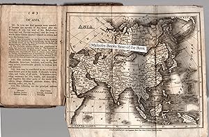
Hardcover. Condition: Fair. The Eighth Edition. Vol I of two vols.17.5 by 10 cms. xii+360 pp. with seventeen engravings and three folding maps, Asia, British Isles, and England and Wales. A defective copy - 3 maps are mising along with some 6 engravings. In contemporary polished calf with panelled spine, gilt titling and original spine labels. Internally showing wear through use but good overall. A significant textbook of this period with interesting illustrations.
-
A GRAMMAR OF GENERAL GEOGRAPHY For the use of Schools and Young Persons . Revised, corrected & greatly enlarged by Edward Hughes
Published by Longman, Brown, Green & Longmans, 1850
Book
Hardcover. Condition: Very Good. No Jacket. Rebound in hardcover paper over boards with new end papers. Paper labels on boards. 335pp. plus 16pp. ads. 11 folding maps. Wheel from frontis detached and laid in.
-
An Easy Grammar of Geography, Intended As A Companion and Introduction to the "Geography on a Popular Plan for Schools, and Young Persons."
Published by Johnson & Warner, 1816
Hardcover. Condition: Poor. Hardcover. Brown paper over boards with leather over spine. Title page dated 1816. 178 pages. Missing any maps. In poor condition. Appears quite worn overall, with chipping to boards along edges and almost no paper remaining over boards. Front and rear covers remain attached by a thread; spine strip is also beginning to separate from binding. Previous owner's name written several times on endpapers. Pages are toned and foxed with age, but still in reading condition. A very interesting frontispiece, with an illustrated clock of sorts, which is able to be spun and indicate what time it is in cities around the world.
-
A Grammar of General Geography for the Use of Schools and Young Persons
Published by Longman, Orme and Brown, London
Cloth Boards. Condition: Good. No Jacket. NPD, Circa 1840s. Boards and spine have some moderate wear, including chipping, rubbing and bumping. A little dog eared and some maps have chipped edges. Period owner name and doodle to ffep. Size: 16mo 0.0.
-
Geography illustrated on A Popular Plan; for the Use of Schools and Young Persons
Published by Longman, Hurst, Rees, Orme and Brown, London, 1815
Hardcover. Condition: Fair. Seventh Edition. 8vo. 676pp. A good working copy with some scuffing and wear to leather covers, back cover virtually detached, leather spine split vertically in centre. Fold-out maps worn with tears to folds. Some foxing. Book.
-
A Grammar of Geography for the Use of Schools with Maps and illustrations
Published by Thomas Tegg, London, 1840
Seller: Midway Book Store (ABAA), St. Paul, MN, U.S.A.
Association Member: ABAA ILAB MWABA
Seller Rating:

Hardcover. Condition: good. Improved and Enlarged edition. 24mo. (6" x 4"). Rebound. 242pp with a one page list of other popular school books published by Tegg in rear of book. Five folded maps (repaired with clear tape) and engravings as well as moveable wheel indicating times in difference countries. Stamps of previous owner's name. Staining to frontispiece and title page and a few other pages.
-
Rev. Goldsmith's Grammar of General Geography for the Use of Schools.
Published by Longman Brown. London c., 1840
Map
Small Hb. With num. maps and engravings. Sl. scuffed and pulled o/w G.
-
A Geographical View of the World, Embracing the Manners, Customs, and Pursuits of Every Nation
Published by William Reed, New York, 1826
leather. 2nd American. 8 illustrations. Good / full leather boards / text foxed with some stains.
-
A General View of the Manners, Customs and Curiosities of Nations: including A Geographical Description of the Earth, Volume II, only
Published by Benjamin Warner, 1817
Book
Hardcover. Condition: Good. Philadelphia, 1817; Volume II, only; leather covered boards; heavy edge and corner wear with board exposed; tape repair at spine' spine edges chipped; 12mo - over 6 3/4" to 7 3/4" tall; end papers toned; interior foxed; previous owner's name on; free front end paper; interior clean and unmarked; 252 pages.
-
Hardcover. Condition: Good. Signature and date (1852) on title page. Original brown calf with bright gilt decoration. There is a 3cm split to the lower rear edge of the spine. The frontispiece is a, still working, moving dial designed to tell the time in various places of significance such as Botany Bay, Ispahan, Pellew Is. With illustrations and pull-out maps. 179 pages.
-
Hardcover. Condition: Fair. Full title A Grammar of General Geography For the Use of Schools and Young Persons.
-
The Natural and Artificial Wonders of The United Kingdom: With Engravings. In Three Volumes. COMPLETE.
Published by G.B. Whittaker, GB, 1825
Seller: Richard Sylvanus Williams (Est 1976), WINTERTON, United Kingdom
Seller Rating:
First Edition
Hardback. Condition: Good. 1st Edition. Textually complete (360, 360 and 356 pages). There are 98 images on 59 plates (I, 38 on 22, II 23 on 18, III 37 on 19). Plates do not always match lists. Vol I adds two images at page 1 (St Michaels Mount and Lindisfarn) but lacks two images at page 206 (Kew/Brighton Palaces), Vol II adds one image on one plate (Christ Church, Oxford) . Bound in old quarter dark brown leather lettered in gold and marbled boards. Volume one has owners names and scribble at start of book and lacks top of title page (two lines of title lost now replaced in facsimile). Texts are quite tight, covers worn but all holding well. A few plates with slight damage and all with varying degrees of spotting. So this is just a good working set. SPECIAL POSTAGE RATES APPLY Packed weight 1200g.
-
![Seller image for Grammar of Geography for the Use of Schools and Young Persons [with volvelle] for sale by Christian White Rare Books Ltd](https://pictures.abebooks.com/inventory/md/md30793234342.jpg)
Grammar of Geography for the Use of Schools and Young Persons [with volvelle]
Published by London T Allman 1859, 1859
Seller: Christian White Rare Books Ltd, Ilkley, YORKS, United Kingdom
Association Member: ABA ILAB PBFA
Seller Rating:
Book
Condition: Good. [volvelle] pp 160 The 1859 edition of Goldsmith's Geography revised by Kenny with the volvelle frontispiece present which allows the reader to calculate world time zones. Bound in publisher's textured cloth, rubbed, with gilt lettering to the upper cover; lacking the first blank; some fingermarking. Good Please contact Christian White Rare Books Ltd for more information or images of this item.
-
Geograph, Illustrated on a Popular Plan; for the use of Schools and Young Persons
Published by Longman, Hurst, Rees, Orme and Brown, London, 1816
Seller: Old Favorites Bookshop LTD (since 1954), Stouffville, ON, Canada
Seller Rating:
Book
Hardcover. Condition: Very Good Condition. 65 Engravings with fold out maps. (illustrator). 8th edition. Printed by J. McGowan, London. This copy has been rebound in modern green cloth.All fore edges gilt. Gilt Ruling, title and author on spine. 744pp. All engravings and fold out maps present. Paper is slightly tanned.
-

The British Empire in 1825; Being A Popular Grammar of British Geography in the Four Quarters of the World
Published by G.B. Whittaker, London
Seller: Between the Covers-Rare Books, Inc. ABAA, Gloucester City, NJ, U.S.A.
Association Member: ABAA ESA ILAB IOBA
Seller Rating:
Hardcover. Condition: Good. Fifteenth edition. Good in full leather with wear along the edges, hinges split, spine split in the middle, All seven maps are present and in very good condition, pages and maps are slightly age toned, ink notation on the front endpaper.
-
A Grammar of General Geography for the Use of Schools and Young Persons with Maps & Engravings. A New Edition Corrected and Modernised;
Published by London, Longman, Hurst, Rees, Orme, Brown and Green. nd ( Preface dated 1824);, 1824
Hardback. 5.5" x 3.5". Good condition. "This edition has been embellished with a new set of elegant engravings of all the capital cities in the world, and representations of Costume." 188pp with 7 fold-out Maps & many illustrations. Most maps have small closed tears, map of Britain has corner torn off. Brown boards with gilt title on front.
-
A Geographical View of the World, Embracing the Manners, Customs, and Pursuits of Every Nation; Founded on the Best Authorities
Published by E. Hopkins and W. Reed, New York, 1826
Seller: Evening Star Books, ABAA/ILAB, Madison, WI, U.S.A.
Association Member: ABAA ILAB IOBA
Seller Rating:
First Edition
Hardcover. Condition: Good+. First American edition. 8vo. [3], 4-406, [3], 2-46, [2] (pages of publisher's advertisements) pp. Full contemporary sheep with gilt lettering and decorations on the spine; all edges yellow. Illustrated with a frontispiece and seven plates. With passages on Nepal, Italy, Afghanistan, China, and various other places. Rubbing to the binding and the leaves somewhat brittle, two leaves with a tear.
-
The Biographical Class Book; consisting of four hundred and fifty lives of distinguished characters of all ages and countries: arranged as lessons for every day in the year for the use of schools
Published by Published by Sir Richard Phillips and Co., London, 1820
, iv, 549, [7], complete with 24 leaves of plates which each have 5 or 6 engraved portraits Second Edition , boards detached, spine cracked in three places thus book split but complete, boards well rubbed and with remains of sellotape at edges, previous owner's inscription on front board, lacks front free endpaper, light patches of foxing to pages and plates, , full brown calf 12mo, 18 x 11 cm Hardback ISBN:
-
GEOGRAPHY for the Use of Schools and Youg Persons in General
Published by Richard Philips, London, 1803
First Edition
Full Leather. Condition: Poor. Fifty Copper-plates (illustrator). First Thus. In full leather, heavy wear and rubbing, spine cracked in several places, rear board missing, soiling staining to many pages of text; binding split and shaken, staining and creasing to illustrations and maps; a fair to poor reference copy; 8vo, 560pp. Size: 8vo - over 7�" - 9�" tall. Book.
-
Leather. Illustrated (illustrator). Revised Ed. Inside clean with light foxing, all maps present with illustrations. 4 pages of ads at back. Good / leather covers rubbed / worn at corners / edges.
-
GOLDSMITH'S GRAMMAR OF GEOGRAPHY for the use of schools and young persons with Maps and Engravings
Published by Longman, Rees, Orme, Brown and Green, London, 1827
Book
Hardcover. Condition: Good. Dust Jacket Condition: No Jacket, as Issued. Sydney Hall (maps engraved and drawn by) (illustrator). New Edition. Circa.1827 (dated by first map). Seven folding maps and full-page copper-engravings: Solar and Lunar Eclipse, The Zodiac, The Seasons, Phases of the Moon, Comparative size of Planets, Mariners compass, Theory of the Tides; Vienna, Dutch, Amsterdam; Constantinople, Turks, Rome: London, French, Paris; Lisbon, Madrid; Dublin, Scotch, Edinburgh; Canton, Chinese, Calcutta; Quebec, Indians, Washington; Artificial Globe and Armillary Globe. ***A new edition corrected and modernized. ***Good in original leather boards. Five gilt bordered compartments to spine. Tail of spine frayed and split. Corners of boards worn and bumped. Boards rubbed. Spine worn with top portion missing. Top inner corners of a few rear pages lightly water splashed. Contemporaneous owner's name, place, date to top of contents page: 'William Green, Market Deeping, April 9th 1878.' Owner's name in ink: Green John Deeping London top front pastedown and: R. P. Green, Ness? Deeping to bottom of end of preface and John Green to pages 62 & 63. On rear pastedown contemporaneously in pencil names and places: William Green Market Deeping, Deeping St James, Walter Milford Green Deeping St James, Robert Pearson Green Bow Church Yard London, Arabella Jessie Green. Vignette to title-page. Missing frontispiece? ***Seven folding maps drawn and copper engraved by Sydney Hall, and published by Longman: The World engraved in 1827; please note that the folding Map of Europe is only half complete, half of the map is torn off (still showing Great Britain, Ireland, France and Spain. Map of British Isles torn and creased to edges with small section torn off top right-hand corner removing the Shetland Islands but not the Orkney Islands; Map of Asia not torn - complete; Map of North America torn along one-third of one foldover but complete; map of South America small tear to lower edge - complete; map of Africa complete - has small tear to lower edge. 191 pages plus one-page of publisher's titles to rear. ***Contents: The Solar System, Geographical Definitions, The Whole Earth: Europe: Sweden and Norway, Denmark, Russia, Prussia, Netherlands, Germany: Saxony, Bavaria, Wurtemberg, Hanover, Austria; Turkey in Europe, Ionian Islands, France, Switzerland, Italy, Spain, Portugal, Great Britain and Ireland: England, Wales, Scotland, Ireland, General Summary of Europe; Asia: Asiatic Turkey, Russia in Asia, Chinese Empire: Chinese Proper, Chinese Tartary, Thibet; Japanese Empire, Birman Empire; Hindoostan, Persia, Tartaria, or Independent Tartary, Arabia, Oriental Archipelago, Australasia, Polynesia, General Summary of Asia; America, North America, United States, British Possession in North America, Native Tribes, West Indies; South America, Spanish Republics, Brazil, Guayana; Africa: Egypt, Abyssinia, Barbary, Sierra Leone, Guinea, Caffraria and Cape of Good Hope, Mozambique and Zanguebar, Ajan and Adel Isles; Summary of Africa; General Facts, worthy of being remembered: Physical Geography: seasons and climates, Winds, Earthquakes, Tides, Saltiness of the Sea, Aurora Borealis, Temperature of the Earth, Varieties of the Human Species, Difference of Language and Nation, Difference of Religion, Civilization in its different degrees, Society and forms of Government; Use of the Globes: Problems of the Terrestrial Globe; Problems of the Celestial Globe; etc. ***Turkey in Europe, once the seat of civilization, learning, and the arts, includes ancient Greece and other countries, formerly the finest in the world, but, owing to the Mahometan religion, to the despotism of the government and to the ignorant policy of the Turks, now the most desolate.' ( p 29). ***An early, 1827 antiquarian edition complete in its original leather boards, of interest to collectors of antiquarian maps, antiquarian children's books, geography and travel titles. A scarce pre-Victorian children's book, with all seven maps albeit half of one map torn off as listed above, but unusual to find in the original binding, unrestored.
-
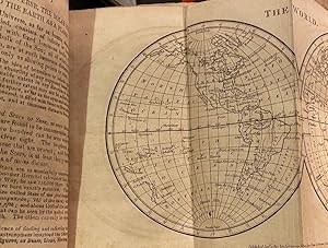
A Grammar of General Geography, for the use of Schools & Young Persons, with Maps & Cuts. Sixty-first edition corrected and Improved 1819
Published by Longman, Hurst, Rees, Orme and Brown, London, 1819
Full Leather Hard Back. Condition: Good. This was a very popular and well used school book, it went though very many DIFFERENT editions & slightly different full titles, this 1819 tome was the 61st edition, it is normal for some or even all pates/maps to be missing, so please check all listing very carefully as many sellers do not list what their book contains/lacks. This copy contains a Frontispiece + 189 pages (inc title page) + 3 page publishers list + 8 plates (lacks 1 �). Condition:overall Fair, Good for age of this children s tome. Full leather hardback binding poor, well rubbed, lacking most of spine. Contents Fair, some inscriptions, well used, some with marks, page 24/5 a/f detached/torn, contains fold-out maps of the Earth (2 circular sides), map of Europe, map of Asia, map of N. America, map of S. America, map of Africa, single page plate of the Globe, Geographical dial at fronticepeice lacks the moveable part at centre, And lacks the fold-out map of the British Islands (only map missing) condition of maps; Earth very good. Europe good, minor edge tear, minor miss-folding map of Asia good, minor edge tears, minor miss-folding. map of N. America good, one third tear, minor edge tears, edge miss-folding (dated 1813) . map of S. America good, minor edge tears, edge miss-folding, wear, dirt map of Africa very good, minor edge wear etc. single page plate of the Globe good, minor edge wear/dirt, base starting to detach. , Geographical dial, minor edge wear/loss, one edge tear (see scan). The list of where maps should be is incorrect, but printer seems to have put them where they should be, not where the list states. Lists 9 plates, this copy has 8, one map missing, ( please note 40 yeas ago, pre 1820 maps like these were regularly removed by map & print sellers as were worth more than the book), some of dial plare lacks moveable part. Also has numerous illustrations of towns within text including Stockholm, Berlin, Naples, Madrid & Washington to name a few. So to sum up, a good 1819 reading copy, with 5 fold-out maps. See all of our scans of this copy Size: 14.5 x 9cm Approx.
-
GEOGRAPHY, Illustrated on A Popular Plan; for the Use of Schools and Young persons. A New Edition.
Published by Longman, Orme, Brown, Green & Longmans, London
Hardcover. Condition: Good. A New Edition. No date given ( but former owners name, address and date to the front pastedown states 1832, which is odd as the catalogue at the end is dated 1840? ) Contemporary ?maroon/brown? patterned leather, spine and extremities are very worn, chipped, creased, rubbed, and chafed with losses. Gilt titling in a gilt decorative border to the spine. xii, + 740 pp, (4pp Latitudes and Longitudes), + 12pp ( Publishers advertisement catalogue). 9 folding maps, including a folding World Hemisphere map as a frontispiece, 3 folding 'charts' and 24 b/w anthropological and topographical plates. Some of the Folding Maps / 'charts' have discoloured and chipped edges where they are proud of the book, etc. Most are (of course) creased. Not a beautiful binding - Rear hinge is detaching, and front hinge is splitting, but Internally mainly very clean tight and bright with lovely steel engravings and fold out plans to illustrate what is a remarkably informative and fascinating account for the children of the early nineteenth century.; 50376; 18cm x 11cm x 6cm.
-
An Easy Grammar of Geography, for Schools and Young Persons; .
Published by Longman, Hurst, Rees, Orme and Brown, London, 1813
Seller: Anah Dunsheath RareBooks ABA ANZAAB ILAB, Auckland, NZ, New Zealand
Association Member: ABA ANZAAB ILAB
Seller Rating:
Book
Hardcover. Condition: Good. iv, 144 pp, adverts, engraved frontispiece, fold out maps. Rebacked, original roan boards, recent calf spine. Comprehensive description of countries and continents, how to use globes and maps, Problems and questions for school children, geographical vocabulary.
-
An Easy Grammar of Geography. Intended as a Companion and Introduction to the Geography on a Popular Plan for Schools and Young Persons.
Published by T. Gillet, 1805
Book
Hardcover. Condition: Fair. Hardback in leather binding, re-bound retaining original boards. A new edition, 1805, printed for Richard Phillips. 144pp, with folding frontispiece map of the world and 6 further folding maps. In sound condition, though upper board splayed. Rear free ep replaced. Maps complete, but some creasing, tears and repairs. One page has a closed tear at the lower end of gutter extending into the text. Overall a clean, sound copy in fair condition. Photos available on request.