Order Total (1 Item Items):
Shipping Destination:

Hunter, William S , Jr (32 results)
Skip to main search results
Product Type
- All Product Types
- Books (27)
- Magazines & Periodicals
- Comics
- Sheet Music
- Art, Prints & Posters (5)
- Photographs
- Maps
-
Manuscripts &
Paper Collectibles
Condition
Binding
Collectible Attributes
- First Edition (6)
- Signed
- Dust Jacket
- Seller-Supplied Images (5)
- Not Printed On Demand (23)
Free Shipping
Seller Location
Seller Rating
-

Manhunt Detective Story Monthly Volume 1, Number 1, January 1953
Published by Eagle Publications
Seller: Wonder Book, Frederick, MD, U.S.A.
Seller Rating:

Condition: Fair. Acceptable condition. Vol. 1, No. 1, January 1953. (Mystery, Periodicals) A readable, intact copy that may have noticeable tears and wear to the spine. All pages of text are present, but they may include extensive notes and highlighting or be heavily stained. Includes reading copy only books. Bundled media such as CDs, DVDs, floppy disks or access codes may not be included.
-

Hunter's Ottawa Scenery In The Vicinity Of Ottawa City, Canada
Published by Legare Street Press, 2023
ISBN 10: 102264193XISBN 13: 9781022641938
Book Print on Demand
Paperback / softback. Condition: New. This item is printed on demand. New copy - Usually dispatched within 5-9 working days.
-
Hunter's Eastern Townships Scenery, Canada East
Published by HardPress Publishing, 2021
ISBN 10: 0461343657ISBN 13: 9780461343656
Book
Paperback. Condition: New. New copy - Usually dispatched within 4 working days.
More buying choices from other sellers on AbeBooks
New offers from US$ 20.54
-
Hunter's Eastern Townships Scenery, Canada East
Published by Legare Street Press, 2022
ISBN 10: 1017252742ISBN 13: 9781017252743
Book Print on Demand
Paperback / softback. Condition: New. This item is printed on demand. New copy - Usually dispatched within 5-9 working days.
More buying choices from other sellers on AbeBooks
New offers from US$ 21.28
-
![Seller image for Hunter's Eastern Townships scenery, Canada East / By W. S. Hunter, junior (1860) [Leatherbound] for sale by S N Books World](https://pictures.abebooks.com/inventory/md/md30638376508.jpg)
Hunter's Eastern Townships scenery, Canada East / By W. S. Hunter, junior (1860) [Leatherbound]
Publication Date: 2022
Book Print on Demand
Leatherbound. Condition: NEW. Leatherbound edition. Condition: New. Leather Binding on Spine and Corners with Golden leaf printing on spine. Bound in genuine leather with Satin ribbon page markers and Spine with raised gilt bands. A perfect gift for your loved ones. Reprinted from 1860 edition. NO changes have been made to the original text. This is NOT a retyped or an ocr'd reprint. Illustrations, Index, if any, are included in black and white. Each page is checked manually before printing. As this print on demand book is reprinted from a very old book, there could be some missing or flawed pages, but we always try to make the book as complete as possible. Fold-outs, if any, are not part of the book. If the original book was published in multiple volumes then this reprint is of only one volume, not the whole set. IF YOU WISH TO ORDER PARTICULAR VOLUME OR ALL THE VOLUMES YOU CAN CONTACT US. Resized as per current standards. Sewing binding for longer life, where the book block is actually sewn (smythe sewn/section sewn) with thread before binding which results in a more durable type of binding. Pages: 114 Language: English Pages: 114.
-

Hunter's Ottawa Scenery In The Vicinity Of Ottawa City, Canada
Published by Legare Street Press, 2023
ISBN 10: 1020540494ISBN 13: 9781020540493
Book
Condition: New.
More buying choices from other sellers on AbeBooks
New offers from US$ 32.77
Used offers from US$ 32.96
Also find Hardcover
-
Hunter's Eastern Townships Scenery, Canada East
Published by LEGARE STREET PR, 2022
ISBN 10: 1017247587ISBN 13: 9781017247589
Book Print on Demand
HRD. Condition: New. New Book. Shipped from UK. THIS BOOK IS PRINTED ON DEMAND. Established seller since 2000.
More buying choices from other sellers on AbeBooks
New offers from US$ 35.79
-
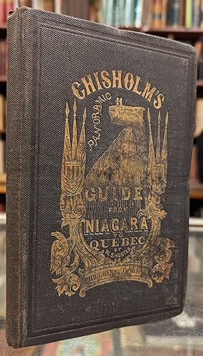
Chisholm's Panoramic Guide from Niagra Falls to Quebec
Published by C.R. Chisholm, 1868
First Edition
Hardcover. Condition: Very good. No jacket. Includes a long foldout map of the Niagra River. Illustrated. Covers worn.
-
Hunter & Pickup's Panoramic Guide from Niagara Falls to Quebec
Publication Date: 1866
Seller: G.S. MacManus Co., ABAA, Bryn Mawr, PA, U.S.A.
Seller Rating:
HUNTER, William, Jr. Hunter & Pickup's Panoramic Guide from Niagara Falls to Quebec. Montreal, 1866. Illus. with numerous engraved views. 11-ft. folding panoramic map. 66pp. Orig. printed wrappers; covers chipped, soiled and cover (with map) detached, else a very good copy.
-
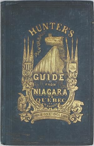
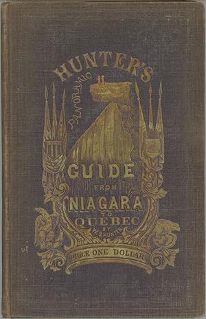
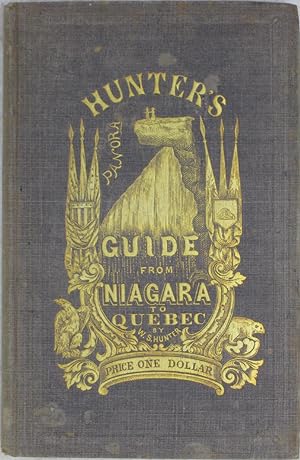
Hunter's Panoramic Guide from Niagara Falls to Quebec.
Published by Boston. Jewett & Company. 1857., 1857
Seller: Brainerd Phillipson Rare Books, Holliston, MA, U.S.A.
Association Member: SNEAB
Seller Rating:
First Edition
First Edition with 1857 on the copyright page. Illustrated with numerous vignettes and full-page plates. With a splendid 10' folding map of Niagara Falls and all the lakes and rivers from Niagara to Quebec. The definitive 19th century guide book on this area. VG- in worn and lightly stained woven brown cloth stamped in gilt on the front boards.An unusual and charming book. First Edition with 1857 on the copyright page.
-
Hunter's Panoramic Guide from Niagara Falls to Quebec
Seller: G.S. MacManus Co., ABAA, Bryn Mawr, PA, U.S.A.
Seller Rating:
First Edition
HUNTER, William S., Jr. Hunter's Panoramic Guide from Niagara Falls to Quebec. Boston: John P. Jewett & Co., 1857. 1st ed. 8vo. Illus. with a long folding panoramic frontispiece, measuring over eight feet long, with engraved views & vignettes throughout the text. 67pp. Orig. cloth. Spine slightly chipped, else a very good copy.
-
Hunter's Ottawa Scenery, in the vicinity of Ottawa City, Canada.
Published by J.H. Bufford's Lith.,, Boston, 1855
Seller: Alexandre Antique Prints, Maps & Books, Toronto, ON, Canada
Seller Rating:

Art / Print / Poster
Condition: Very Good. Image Size : , Platemark Size : , Paper Size : 330x246 (mm), 12.99x9.69 (Inches), Original Hand Coloring, Lithograph.
-
Hunter and Chisholm's Panoramic Guide from Niagara Falls to Quebec. By Wm. S. Hunter, Jr. (1867 Edition)
Published by Montreal: C.R. Chisholm
Seller: Powell's Bookstores Chicago, ABAA, Chicago, IL, U.S.A.
Seller Rating:
Condition: Used - Very Good. 1867. later edition Cloth, 66 pp. Text preceded by the 32-panel fold-out 'panorama' map of the waterways beyween Niagara and Quebec, illustrated with many engraved vignettes of notable ship types, houses, local types, etc. A vey good copy of the Canadian edition of this work (first published by Jewett in 1857). The binding of this edition differs from the U.S. version in that it is dark green instead of gray, and the gilt-stamped decoration from the front cover (common to both editions) is repeated in blind-stamp on the rear cover of the Canadian edition. This copy's fold-out map is is generally good condition, though some of its folds are fragile.
-
Natural Curiosity Ottawa River Canada.
Published by J.H. Bufford's Lith.,, Boston, 1855
Seller: Alexandre Antique Prints, Maps & Books, Toronto, ON, Canada
Seller Rating:
Art / Print / Poster
Condition: Very Good. Image Size : , Platemark Size : , Paper Size : 250x334 (mm), 9.84x13.15 (Inches), Original Hand Coloring, Lithograph.
-
View from Barrack Hill. Ottawa City, Canada.
Published by J.H. Bufford's Lith.,, Boston, 1855
Seller: Alexandre Antique Prints, Maps & Books, Toronto, ON, Canada
Seller Rating:
Art / Print / Poster
Condition: Very Good. Image Size : , Platemark Size : , Paper Size : 252x333 (mm), 9.92x13.11 (Inches), Original Hand Coloring, Lithograph.
-
Birds Eye View of Chaudiere Falls. Ottawa River, Canada.
Published by J.H. Bufford's Lith.,, Boston, 1855
Seller: Alexandre Antique Prints, Maps & Books, Toronto, ON, Canada
Seller Rating:
Art / Print / Poster
Condition: Very Good. Image Size : , Platemark Size : , Paper Size : 252x334 (mm), 9.92x13.15 (Inches), Original Hand Coloring, Lithograph.
-
Suspension Bridge Over Chaudiere Falls.
Published by J.H. Bufford's Lith.,, Boston, 1855
Seller: Alexandre Antique Prints, Maps & Books, Toronto, ON, Canada
Seller Rating:
Art / Print / Poster
Condition: Very Good. Image Size : , Platemark Size : , Paper Size : 252x334 (mm), 9.92x13.15 (Inches), Original Hand Coloring, Lithograph.
-
HUNTER'S PANORAMIC GUIDE FROM NIAGARA FALLS TO QUEBEC. By Wm. S. Hunter, Jr.
Published by Published by John P. Jewett & Company. Cleveland, Boston, 1857
Seller: Currey, L.W. Inc. ABAA/ILAB, Elizabethtown, NY, U.S.A.
Seller Rating:
First Edition
18.7x11.8 cm, pp. [i-vii] viii [9] 10-66 [67] [68: blank] [1]-4: ads, engraved title, profusely illustrated, eleven-foot long folded panorama, original pictorial purple cloth, front panel stamped in gold and blind, spine and rear panels stamped in blind. First U.S. edition. "At the beginning is a folding panoramic view -- approximately 10 feet 14 inches long -- of the route from Niagara Falls to Quebec. It is drawn by Alfred R. Waud (1828-1891) and engraved on wood by John Andrew. [Waud was] one of the Harper illustrators, and during the Civil War combat artist for HARPER'S WEEKLY. He was reportorial in style but capable of doing work of real merit. This is particularly true of some of his magazine illustrations, especially his Western drawings . Throughout the book there are numerous interesting wood engravings (including early views of Toronto, Montreal, and Quebec) by Andrew but there is nothing to indicate that Waud was the draftsman" (Hamilton 1260). Cole (1976) 45. Dow, p. 1225. Sabin 33938. Light wear to cloth at spine ends and corner tips, cloth sunned, mainly spine panel, a very good copy. A remarkably nice copy. (#166751).
-
Hunter's Panoramic Guide from Niagara to Quebec. By Wm. S. Hunter, Jr.
Published by Boston: John P. Jewett & Co.; Cleveland: Henry P.B. Jewett
Seller: Powell's Bookstores Chicago, ABAA, Chicago, IL, U.S.A.
Seller Rating:
Condition: Used - Very Good. 1857. Cloth, 68 pp. + 4 pp. advertisements. Text preceded by the 32-panel fold-out 'paorama' map of the waterways beyween Niagara and Quebec, illustrated with many engraved vignettes of notable ship types, houses, local types, etc. Overall a nice copy, with some fading and spotting to the covers, but a rather bright example of the publisher's elaborate gilt-stamped cover decoration. The map has had a few folds repaired, and a few more show the beginnings of fraying, but it is in very good condition otherwise.
-
Hunter's Eastern Townships Scenery, Canada East.
Published by John Lovel, Montreal, 1860
First Edition
Folio (13 x 10 inches). Tinted lithographed additional title-page (edges repaired with archival tissue), lithographed map showing "the Different Railways by which the Eastern Townships of Canada East may be Reached", and 12 lithographed views of the Eastern Townships (first few plates and preliminaries quite spotted). Original black cloth gilt (rebacked to style). Provenance: with the early ownership inscription of L.B. Masser on the title-page and in the margin of one other; with the ink library stamp of L.J. Casault on the title-page. First edition. Of the Eastern Townships, where he lived, Hunter writes: "As a whole, there is no more beautiful tract of country to be found on the continent of North America, whether we regard its sublime and beautiful mountains, its enchantingly romantic lakes, its picturesque scenery, beautiful rivers, and fertile valleys." (page 7). The plates include: Lake Memphremogog; view from Sugar Loaf looking north over Lake Memphremogog; 2 views looking northwest and south from Owls Head Mountain; Owls Head, Round Island, Whet Stone Island, & Magoon Point; 3 of the St. Francis River; the confluence of the Missauwippi and St. Francis Rivers; the Pinnacle looking north from the Little Lake; the Falls on the Coaticook River; Lake Massauwippi; and a view from the artist's residence in Stanstead. Sabin 33936.
-
Hunter's Ottawa Scenery in the Vicinity of Ottawa City, Canada.
Published by Ottawa City, Canada West, 1855., 1855
First Edition
Folio (13 2/8 x 10 inches). Tinted lithographed title-page and frontispiece, folding lithographed map of north-eastern America, and 13 fine tinted lithographed plates by Bufford of Boston (one or two insignificant spots). Original brown cloth, gilt (extremities a little worn with loss). Provenance: with the engraved bookseller's ticket of Dawson's of Montreal on the front paste-down. First edition, and an attractive copy. "The River Ottawa offers, to the observation of the tourist, objects of the wildest and most romantic interest: there is the mighty Cataract and the silent, sleeping Lake; the stupendous work of the highest art, and the rude simplicity of the roughest shanty; there is the dense forest and the light grove; Nature, in all her varied phases; the work of man in its simplest and its loftiest development. The Ottawa country is little known; but no man visits its magnificent scenery, no man begins to understand its enormous resources, without an expression of admiration at the one and surprise at the other; well, indeed, did the red men, who in ages past gave it its christening name, call it, in their beautiful and harmonious language, the "Great River" (Preface). The fine lithographed plates include: Rideau Falls, the locks at the entrance to Rideau Canal, view from Barrack Hill down the Ottawa, the junction of the Gatineau with the Ottawa, the Suspension Bridge over Chaudiere Falls, the Big Kettle and the Chasm over Chaudiere Falls, a view from inside the Chasm, the Timber slide on Hull side Ottawa City, etc. Abbey, Travel 628; Sabin 33937.
-
Hunter's Ottawa Scenery, in the Vicinity of Ottawa City, Canada
Published by William S. Hunter, Ottawa, 1855
Seller: Karol Krysik Books ABAC/ILAB, IOBA, PBFA, Toronto, ON, Canada
Association Member: ABAC ILAB IOBA PBFA
Seller Rating:
Cloth. Condition: Near Fine. Winslow Homer et al (illustrator). 2nd Edition. Folio. Second edition. Folio. 19 pp. 13 lithographs plus vignette title and frontispiece, and folding map. Blind stamped dark brown cloth with gilt circle and titles on the front panel. All edges gilt. Rebacked in black cloth and new endpapers, but otherwise a very clean copy outside and in, with virtually no foxing. Important early images of Canada's capital city.