Order Total (1 Item Items):
Shipping Destination:

Manuscript; Maps (37 results)
Skip to main search results
Product Type
- All Product Types
- Books (31)
- Magazines & Periodicals
- Comics
- Sheet Music
- Art, Prints & Posters
- Photographs
- Maps (4)
-
Manuscripts &
Paper Collectibles (2)
Condition
- All Conditions
- New
- Used
Binding
Collectible Attributes
- First Edition (7)
- Signed (2)
- Dust Jacket (3)
- Seller-Supplied Images (23)
- Not Printed On Demand
Free Shipping
Seller Location
Seller Rating
-

WAYS AND MEANS (BOOK NO. 4759)
Published by Lindsay Publications, 1988
ISBN 10: 0917914759ISBN 13: 9780917914751
Book
Paperback. Condition: Very Good. 125 Illustrations Of Religious And Secular Scenes From Illuminated Manuscripts And The Earliest Maps. (illustrator). Connecting readers with great books since 1972! Used books may not include companion materials, and may have some shelf wear or limited writing. We ship orders daily and Customer Service is our top priority!.
More buying choices from other sellers on AbeBooks
Used offers from US$ 8.30
Also find First Edition
-

A Pedestrian Tour Through the Islands of Guernsey and Jersey
Published by Phillimore, Chichester, 1992
ISBN 10: 0850338379ISBN 13: 9780850338379
Book First Edition
Hardback. Condition: Fine. Dust Jacket Condition: Fine. 24 Drawings By the Author Plus Frontis Map Plus Examples of the Original Manuscript Plus Family Tree (illustrator). 1st. 78 pp. New.
-
The Astrology of I Ching
Published by Routledge & Kegan Paul, London, 1979
ISBN 10: 0710002580ISBN 13: 9780710002587
Book
Soft Cover. Condition: Good. Reprint.
-
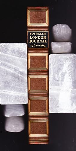
Boswell's London Journal 1762-1763
Published by McGraw-Hill Book Company, 1950
Seller: Frogtown Books, Inc. ABAA, Toledo, OH, U.S.A.
Seller Rating:

Condition: Condition is fine. Illustrated with map of London and two photos of original manuscript. (illustrator). De Luxe Edition. The Yale Editions of the Private Papers of James Boswell. Preface by Christopher Morley. Royal 8vo. 9-1/2" x 6-1/2". 370 pp. including index. Top edge gilt. Simple, elegant brown leather binding with raised bands. Marbled endpapers.
-

L'Ing�nieur artiste. Dessins anciens de l'Ecole des ponts et chauss�es.
Published by Paris, Presses Ponts et Chauss�es, 1989., 1989
circa 37 x 27 cm. 206 pp., 1 f., with many plates in colour Original cloth with dust-jacket Large monograph on watercolour plans and drawings of engineers and architects showing designs for buildings, machines, maritime structures, roads, artwork etc. - Just the jacket a little rubbed, else fine, clean.
-
Blue Buckram Hardback. Condition: Very Good. Dust Jacket Condition: No Jackets. Plates, Drawings, Maps, Plans (illustrator). First Editions. xxxii+264; vi+265-506 pp., 108 plates, many text figures, plans, maps, exlib with usual stamps, ancient history, archaeology, architecture of Scottish border county of Roxburgh, including Melrose & Kelso abbeys, clean vols. vg but with slight wear to spine ends incl one small chip [nothing serious] Size: 4to.
-
Fein gemalte, aquarellierte Zeichnung einer Festung aus der Vogelschau, wohl Saint Venant in Nordost-Frankreich.
Published by Frankreich?, um 1720., 1720
circa 20 x 23 cm. 1 Blatt verso weiss "Aquarell �ber Tusche auf festem Papier in Schwarz, Rosa und verschiedenen Gr�nt�nen. Unten rechts alt als "St. Venant" bezeichnet. Im Spanischen Erbfolgekrieg fand 1710 eine Belagerung von Saint-Venant statt. " - Sauber, dekorativ.
-
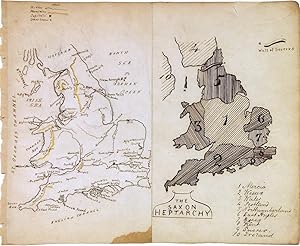
The Saxon Heptarchy. England and Wales
Seller: Argosy Book Store, ABAA, ILAB, New York, NY, U.S.A.
Seller Rating:
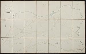
Map. Pen and ink with watercolor. Sheet measures 7 x 8.5". This beautiful schoolgirl or schoolboy manuscript map of England and Wales beautifully depicts from Scotland south to the English Channel. Essentially two maps on a single sheet, the left map depicts the region with detailed topography throughout. Towns, rivers and mountains are noted with a key in the top left corner. The right hand side of the map depicts "The Saxon Heptarchy" and territories are numbered and shaded in. A key in the bottom right lists the territories numbered on the map. The Wall of Severus is identified. The speculative Wall of Severus was supposedly built by the Roman Emperor Septimius Severus as a defensive fortification, but was most likely mistaken for either the Antonine Wall or the Hardian's Wall. The map is in good condition with minor wear along the original centerfold. Small stain in the bottom of centerfold. Minor toning and foxing with some edge wear.This map dates to circa 1880 and was most likely made by a student or apprentice as training in geography, drafting, and penmanship. Manuscript map-making was a useful educational tool in the 19th century, a period of imperialism and increased world trade in which geography grew significantly as a field of study.In the United States and northwestern Europe, reform movements that sought to improve the quality and accessibility of childhood education pushed for the inclusion of geography in school curricula. One common method of teaching was the making of manuscript maps. Working from wall maps, globes, and atlases, students were made to meticulously hand-reproduce maps in pen and ink and with watercolor. Such exercises not only provided a way to review and retain geographical knowledge, but they also functioned as training in penmanship, calligraphy, and drafting. This map is a lovely document that straddles the line between art and geography.
-
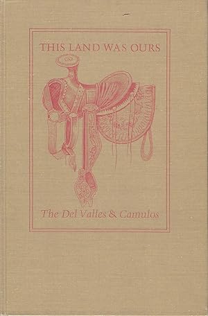
THIS LAND WAS OURS: THE DEL VALLES AND CAMULOS
Published by Ventura County Historical Society, Venture, California, 1977
Seller: Antic Hay Books, Asbury Park, NJ, U.S.A.
Seller Rating:
First Edition Signed
Editied by Grant E. Smith. Illustrated with dozens of historic black & white photographs, a facsimile of a manuscript map, and map-illustrated endpapers. (illustrator). Very Good (covers nice; contents clean & tight); nice d/j. Tall 8vo., pictorial tan cloth, stamped in orange, in the original clear acetate dust jacket; 266 pages First Edition. Limited Edition of 1,000 copies. Signed presentation from Smith on a front black page: "For Everett H. Black- Wallace E. Smith. Ventura Nov. 1978." Rancho Camulos, now known as Rancho Camulos Museum, is a ranch located in the Santa Clara River Valley. California. It was the home of Ygnacio del Valle, a Californio alcalde of the Pueblo de Los Angeles in the 19th century and later elected member of the California State Assembly. The ranch was known as the Home of Ramona because it was widely believed to have been the setting of the popular 1884 novel Ramona by Helen Hunt Jackson. The novel helped to raise awareness about the California lifestyle and romanticized "the mission and rancho era of California history.".
-
Narrative of a Voyage to California Ports in 1841-42. Together with Voyages to Sitka, the Sandwich Islands & Okhotsk. . . .
Published by The Private Press of Thomas C. Russell, San Francisco, 1930
Book
Hardcover. Condition: Near Fine. Engraved portrait of Simpson is the frontispiece. Large foldout map of Simson's Route, and a facsimile of the original manuscript (illustrator). First printing of this edition. Near fine in cloth-covered boards with a paper spine label. Sunning and foxing on the top edge. Originally published in 1847 by Lea and Blanchard and in London by Henry Colburn. Facsimiles of the title-pages of both of these editions are included as well as a second engraved portrait of the author. A handsomely designed and printed book.
-
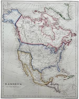
N. America. F.J. Bowden fecit.
Published by c. 1860?, 1860
Seller: Michael S. Kemp, Bookseller, Sheerness, KENT, United Kingdom
Association Member: PBFA
Seller Rating:

Map
Hand coloured manuscript map, 350 x 275 mm. to border. Paper watermarked 1860. An attractive map showing the United States prior to its conquest of California in 1846/7. Probably copied from a printed atlas.
-
Commune de Nades
Published by Nades, 1827
Seller: Donald A. Heald Rare Books (ABAA), New York, NY, U.S.A.
Seller Rating:
Map
Watercolor, pen and ink, and pencil. Paper dissected and backed on brown linen. Two sheets, dissected and backed on linen. Sheet size: 26 3/8 x 40 1/8 inches. These are two hand-drawn maps of the small village of Nades in the Auvergne region in central France on folded, linen backed and dissected sheets done in 1827. They show the major geographical features: a number of forests and rivers, and property lots with the names of their owners. They appear to be maps of two different sections of the town, and may have been drawn by different surveyors.
-
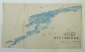
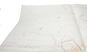
Map of Otsikwake or Black Lake, St. Lawrence County New York
Seller: Argosy Book Store, ABAA, ILAB, New York, NY, U.S.A.
Seller Rating:
Map. Pen and ink with watercolor. Image measures 13 x 23". This pen and ink map of Black Lake in New York State was likely produced in the mid-19th century by a student or apprentice as training in geography, drafting, and penmanship. The lake, otherwise known at Otsikwake, is located in St. Lawrence County near the Canadian border. Significant locales are labeled in a fashion redolent of printed maps of the period, yet the idiosyncratic handwriting of the mapmaker gives the map a more artistic quality. The blue wash of watercolor that colors the lake adds to the map's aesthetic qualities. The map is drawn on two pieces of paper glued together, with some red markings at the seam. It has some wrinkles and folds consistent with its hand-drawn format. Manuscript map-making was a useful educational tool in the 19th century, a period of imperialism and increased world trade in which geography grew significantly as a field of study. In the United States and northwestern Europe, reform movements that sought to improve the quality and accessibility of childhood education pushed for the inclusion of geography in school curricula. One common method of teaching was the making of manuscript maps. Working from wall maps, globes, and atlases, students were made to meticulously hand-reproduce maps in pen and ink and with watercolor. Such exercises not only provided a way to review and retain geographical knowledge, but they also functioned as training in penmanship, calligraphy, and drafting. Today, these idiosyncratic projects offer a glimpse into the way 19th-century youth engaged with the world around them.
-
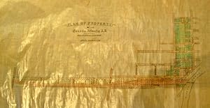
Plan of Property. -of the Canada Atlantic R.R. and Promoters Thereof. Scale 200 feet to 1 inch. Manuscript Map. On coated linen, in black & two colours, Plan includes from east west Gilmour, Argyle, Catharine and Isabella Streets., and from north to south; the Rideau Canal at Pretoria Bridge, Cartier, Elgin, Metcalfe, O'Connor, Bank to Concession Street. (Bronson ?). Lots are numbered
Published by Nd. [1890/1900?], 1900
Seller: J. Patrick McGahern Books Inc. (ABAC), Ottawa, ON, Canada
Association Member: ABAC ILAB IOBA
Seller Rating:
No Binding. Condition: Fine. sheet size: 69.5 (27.5") x 110 (43.25"), very good to fine (n12) J.R. Booth's Canada Atlantic Railroad, the worlds longest privately owned company, was sold to the Grand Trunk in 1905 for $14 million. Booth launched its construction in 1879, to speed his lumber to markets in northeastern American, via the Central Vermont Railway. The City of Ottawa thus found itself with a direct link to Boston. He later expanded the system west to Georgian Bay; this branch, which was complete in 1896, was known as the Ottawa, Arnprior and Parry Sound Railway. The whole system to Alburg, Vermont was then amalgamated as the Canada Atlantic Railway. (Trinnell. J.R. Booth).
-
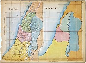
Map. Pen and ink with watercolor. Image measures 7 x 8.5". This beautifully hand colored schoolgirl or schoolboy manuscript map of Canaan and Palestine (Israel or Holy Land) covers from Arish in northern Sinai north beyond Beirut. The Sea of Galilee and the Dead Sea are included. Essentially two maps on the same sheet, the left hand map depicts the region as it existed during Biblical times, when it was called Canaan. The Twelve Tribes of Israel are identified along with ancient place names. Topography is beautifully rendered.The right hand side map covers the same region, but is not labeled except for the title 'Palestine'. Territorial divisions are color coded. The map is in good condition with vivid hand color. On thin paper, with minor foxing and toning. Top margin with some manuscript text cut off. This map dates to circa 1880 and was most likely made by a student or apprentice as training in geography, drafting, and penmanship. Manuscript map-making was a useful educational tool in the 19th century, a period of imperialism and increased world trade in which geography grew significantly as a field of study.In the United States and northwestern Europe, reform movements that sought to improve the quality and accessibility of childhood education pushed for the inclusion of geography in school curricula. One common method of teaching was the making of manuscript maps. Working from wall maps, globes, and atlases, students were made to meticulously hand-reproduce maps in pen and ink and with watercolor. Such exercises not only provided a way to review and retain geographical knowledge, but they also functioned as training in penmanship, calligraphy, and drafting. This map is a lovely document that straddles the line between art and geography.
-
Slaget wed Zornsdorff den 25de Augusti 1758.
No place and date. (probably Denmark late 18th century). Handpainted map in ink and watercolour. 25 x 41 cm. In silver frame. Slightly foxed overall. Seven Years War. The Battle of Zorndorf in Prussia, a Prussian army of 25,000 men under Frederick fought to a standstill with a Russian army of 40,000 commanded by Count Fermor. The Russians withdrew from the field. In the undecided Battle of Tornow on September 25, a Swedish army repulsed six assaults by a Prussian army. On October 14, the Austrians surprised the main Prussian army at the Battle of Hochkirk. Frederick lost much of his artillery but retreated in good order.
-
Grund Tegning af F�stningen og Castellet i Leystad.
No place and date (probably Denmark, late 18th century). Hand painted map in ink and water colour. 26,5 x 41 cm. Silver frame. Overall slightly foxed. Neustadt (G�og.) German town in the Duchy of Brunswick-L�neburg, four miles N. O. of Hanover, on the river Leyne. The map depicts the the fortifications and the river.
-
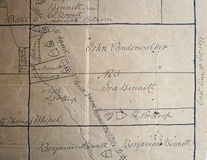
Manuscript map of Deposit and Bennettsville
Published by early-19th century, New York
Seller: Sanctuary Books, A.B.A.A., New York, NY, U.S.A.
Seller Rating:
Ephemera. Condition: Very Good+. Single leaf (about 22x19 inches), drawing in black in on the recto only. Shows lots 1-6 and identifies the road and brook that runs through them, also lists the ownser of each lot and a rough lay-out of houses. Somewhat crude, but chamring. Some light foxing; flattened creases from folding.
-
Cartas y planos in�ditos de los siglos XVII y XVIII y del primer decenio de XIX, conservados en el archivo de la direcci�n de geodesia, catastro y mapa de la provincia de Buenos Aires, con una regesta y observaciones cr�ticas.
Published by Buenos Aires, Jacobo Peuser, 1930., 1930
Seller: H�nersdorff Rare Books ABA ILAB, London, United Kingdom
Seller Rating:

Book
Hardcover. Condition: Good. No Jacket. OUTES, Felix. Cartas y planos in�ditos de los siglos XVII y XVIII y del primer decenio de XIX, conservados en el archivo de la direcci�n de geodesia, catastro y mapa de la provincia de Buenos Aires, con una regesta y observaciones cr�ticasFolio. Buenos Aires, Jacobo Peuser, 1930. 45 + [3]p. With 52 plates, several folding. Contemporary vellum boards, publisher's printed wrappers bound in. Unpublished manuscript maps and plans of the 17th to early 19th century giving maps and plans of coastal areas including ports and the layout of early towns (C�rdoba, Tucum�n, Salta, La Paz) and local property boundaries. Each is individually catalogued and described with measurements, state of preservation, and extensive bibliographical reference. 3 indexes provide names of persons, places and a 6-part classification of the maps - I. General regional maps; II. 'Hidrogr�ficas' - ports, rivers and coast lines; III. Specific areas considered important - the southern border of Buenos Aires, reconquered land in the department of S. Miguel; IV. Plans of cities and towns, see above; V. 'Colonia del Sacramento'; VI. 'Parcelamiento de tierras' - designated plots of land; included is a 1774 map of Buenos Aires with allotments of land ownership named, similarly 5 maps show properties along the River Plate, and there is a map of an extensive private estate. The work is published by the Instituto de Investigaciones Geogr�ficas (Serie B, Documentos Cartogr�ficos no 3); the author was a director of the Institute. Text lightly foxed, condition, on handmade paper. Palau 207379.
-
Prokt ykropleiia (Varna). Dopol. otd. Shtat. Kapitan Scrodel'uikov.
Varna 1888-89. 131 x 126 cm. joined by 4 sheets. Large manuscript surveying map of the fortress of Varna and its vicinity of with contour lines and defensive fortresses, including the fortified lines along the Black Sea coast. Depicting in all 19 defensive installations in all directions from Varna. Surveyed by the Russian captain, Kapitan Scrodel'uikov. Pen and ink with watercolour. With scale. On good thick paper. With 4 small punched holes (stars).
-
With two full page coloured maps and nineteen full page illustrations of which one is two-coloured. The main part is the copy of K�s' illustrated, manuscript text. (illustrator). With two full page coloured maps and nineteen full page illustrations of which one is two-coloured. The main part is the copy of K�s' illustrated, manuscript text. First edition. Published as annex of "Magyar Iparműv�szet" Vol. 14. Text in Hungarian, printed in black, blue and red. Coll.: (2 [editorial foreword]), 8 [printed text, on different paper], 57 [last page printed on recto of rear panel of the wrappers] p. In original, illustrated wrappers, printed in black, blue and red. K�s' second book, with twenty-two full page illustrations in his unique, Translyvanian Art Nouveau style. K�s' illustrated, historical, ethnographic, architectural essay about Kalotaszeg and the Szeklers' art and craftsmanship. K�roly K�s (1883-1977) was a Hungarian architect, writer, graphic artist, ethnologist, publisher and politician. Both in graphic art and architecture he was influenced by Vienna Secession, Art Nouveau and the traditional Transylvanian style that resulted a unique and particular mixture in his works. . The authors inscription on the cover from 1911. (The name is scraped out). Spine restored. Otherwise in very good condition. In original, illustrated wrappers, printed in black, blue and red First edition. Published as annex of "Magyar Iparműv�szet" Vol. 14. Text in Hungarian, printed in black, blue and red. Coll.: (2 [editorial foreword]), 8 [printed text, on different paper], 57 [last page printed on recto of rear panel of the wrappers] p.
-
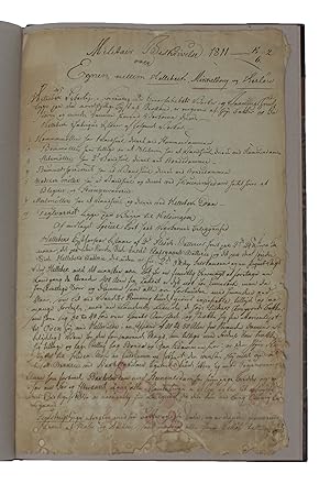
Militair Beskrivelse 1811 over Egnen mellem Helleb�k, Mikkelborg og Herl�w (tekstens h�ndskrevne titel) + Kort over Egnen mellem Helleb�k, Mikkelborg og Herl�w. Aaret 1810.
1810-11. Folio. (36,5x23,5 cm.). Nyere hldrbd. i brun oaseged. Best�r af 9 sider i h�ndskreven folio, uden forfatterangivelse. Bladenes kanter og bund lidt flossede, nederste del af tekstsiderne med lidt misfarvning og skjolder. Det h�ndtegnede kort (20,5x21,5 cm.) er opsat bagerst, men noget brunet, med en revne og fragilt. Det er h�ndkoloreret og med bogstavsignaturer (A-K) angives kortets skovomr�der (A. Teglstrup Hegn etc.etc.). De p� kortet indf�rte tal (1-125) henviser til en medf�lgende planche "Tallenes Forklaring" som navngiver 125 steder, som i�vrigt er omtalt i tekstdelen. Unik milit�r-topografisk beskrivelse af Nord�stsj�lland fra Helleb�k i nord over Helsing�r, Lokkerup, Snekkersten, Esperg�rde, Humleb�k, Sletten, Nivaa til Mikkelborg i syd samt de bagved liggende landskaber, landsbyer, g�rde, skove, s�er m.v. i en "trekant" som udg�res af hj�rnerne Helleb�k/Helsing�r - Frederiksborg/Herl�w - Mikkelborg.Efter engl�ndernes landgang 1807 under Syv-�rskrigen, kom Sundets kystforsvar under n�je inspektion, idet engl�nderne i 1807, uden at m�de nogen modstand, landsatte deres h�r mellem Skodsborg og Vedb�k. Den foreliggende topografiske unders�gelse m� anskues under denne synsvinkel" og det st�r klart, at det er en milit�r-topograf som har affattet beretningen, som ud over en fyldig topografisk beskrivelse indeholder vurderinger af, hvorledes landomr�det, med henblik p� en gentagelse af et angreb, bedre kunne bef�stes og beskyttes. S�ledes anbefales anl�gget af forskellige kystbatterier til beskydning ved angreb, og et telegraf-system foresl�es (semifor-telegrafi). Af et s�dant indeholder beskrivelsen endda en lille tegning.Et eksempel p� den topografiske beskrivelse: "Snekkersteen og Lokkerup er ubetydelige Fiskerbyer. (de).t�t bag Snekkersteen v�rende h�ie Bakker som hen ad Lokkerup (er) noget Skovgroet, tilbyder et godt Forsvar mod en (Landed) Fiende, og is�r da Skands�re Batterie kan assistere (den) venstre Fl�y - (ved) Snekkersteen er en Kystsignal(streng), som signalerer til Gaard K�st Signalen ? paa Alsho�, ved Nyboe (?) Strandstykke fra Helsing�r til Lokkerup er meget sandig og besv�rlig at passere (for ?) alle Troppe Arter.etc.Agemose er en liden bye som er og kommet ved fulgte almindelige Udskiftning.terrainet som (omslutter).fra Fuglef�ngehusene til Agemose og Teglstrup hegn bestaaer (for) st�rstedelen af L�ng og af.".
-
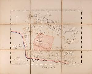
A folding map of Beshagard in south-eastern Persia, containing coastlines of Persian Gulf and the Gulf of Oman. Commissioned by Suleyman Mirza for the Royal Armoury.
Published by Qajar Persia AH 1893-94 AD, 1311
Book
A single folding manuscript map of Beshagard in south-eastern Persia, copied by 'Sulayman Qajar' and hand-coloured, copied on 6 sheets and linen-backed, total 475 by 605 mm; with two marbled paper wrappers pasted over board sections (forming covers when folded), paper label to upper cover, extremities a little rubbed, internally bright and attractive. A label pasted to the front wrapper reads 'Map of Beshagard, the work of Sulayman Mirza', and the map itself is entitled 'The work of the servant of the court Sulayman Qajar, the colonel of the August Armoury, 1311 AH' (1893-94 AD)'. Suleyman Mirza has not been identified.
-
![Seller image for Neue und Vollkom[m]ene Carten, des K�nigreich Bosnien, Sambt ihren darzugeh�rigen Provincien. Wie auch dessen Grosse und Kleine Vestungen, Sambt anderen �rthern, So Sich bis auff das 1737te Jahr befinden und Solche angemercket worden Seyn for sale by F�ldv�ri Books](https://pictures.abebooks.com/inventory/md/md14630165401.jpg)
Condition: In fine condition. Manuscript, colored military map of Bosnia on linen with green silk edges, by Johannes Weingartner. 660 � 470 mm; 620 � 430 mm. Showing the borders and the fronts of the Habsburg Empire in Dalmatia and the Ottoman Empire in Bosnia on the day of the battle of Banja Luka, August 4, 1737. It was one of the main battles of the Russo-Turkish(-Austro) War (1735-1739) in which the Ottomans led by, Hekimo� lu Ali Pasha (1689-1758) grand vizier, defeated the Austrians, who entered the war a month before in July, 1737. With four vignettes of views of principal cities: Banja Luka, Biha� , Sarajevo (written "Seraglio" on the map, which is equivalent to "saray" or "serail" which means the governor's palace in Turkish) and Zvornik. . Manuscript, colored military map of Bosnia on linen with green silk edges, by Johannes Weingartner.
-
[Suitte du journal depuis le d�part de Manille NIII 1755].1755. Manuscript of 24 pages, 6 printed maps on cardboard.
Seller: Antiquariaat FORUM BV, Houten, Netherlands
Seller Rating:
[24] pp.This wonderful logbook details the journey of a French captain from Manila to the Maluku Islands in today s Indonesia. The journey took place during the months of March to May of 1755. The captain of the ship recounted with great detail the events of every day of the journey, with detailed daily accounts of the weather, winds, manoeuvres of the ship, its departures, anchorages, and precise coordinates at every point of the journey. The captain furthermore had a keen eye for the geographical and nautical details along the journey. He recounted the exact locations of for example sandbanks and bays, where ships and their crews can take provisions and fresh water. The accounts are detailed and captivating: "After our boats were back on board, we set sail [.] in the afternoon to moor under the old Portuguese fort on the Solor island [Indonesia], the winds for the tide were fresh at 1:34 a.m. [.] sand and gravel, and then I went back to mooring. The pavilion of the fort [.] the village is under the said fort at 3 cables from us [.]". The captain goes on to describe the geographical features of the islands as well as other places en route with great detail. Curiously, we find inscriptions in Spanish and the names of one don Phelipe Qui, who describes himself as "el piloto" and one Padre Don Estevan de Melo. The latter might be identical with Don Estevan Roxas y Melo, a native of Lima, Peru and secretary to the Archbishop of Manila, Rodriguez, since 1736. Roxas y Melo was part of the 1751 reconstruction of the Cathedral of Manila, working under the auspice of the Italian architect Juan de Uguccioni.The logbook comes with six printed maps, partly illustrating the journey of the captain, pasted on contemporary cardboard. They depict the Bay of Sulavesi with the city of Bantang, Pitcairn, the coast of New Guinea, the coast of Queensland, the Santa Cruz Islands in the present-day Solomon Islands and Alejandro Selkirk Island. The plates stem from the French translation of James Hawkesworth s An Account of the Voyages (Hawkesworth, Relation des voyages entrepris par ordre de sa Majest� Britannique, actuellement regnante; pour faire des d�couvertes dans l'hemisph�re meridional, Paris 1774).Some holes on the first sheet, not affecting the text. Small water damage, some slighlty affecting the text. Remnants of seals on last page. Otherwise in good condition.
-
Single sheet (sheet size 16 7/8 x 22 6/8; 16 1/8 x 22 2/8 to the neat line) full margins. A fine, detailed and beautiful manuscript map of the Chateau and town of Ham, the title, key and scale in a panel on the left of the map; with exceptional original hand-color in full (small corner missing under left, old fold marks, stain upper left). Provenance: Le 10 Octobre 1727 plan de ham relatif M. Demur au projet de 1728 on verso. A lovely manuscript map of Ham in the northern of France, under the reign of Louis XV. Ham is a commune in Picardie, its history goes back to 1108 when the abbey of Ham was founded by Odon II, the land lord. From 1216-1234 the castle was built under the order of Odon IV. Due to its strategic location close to the border of the kingdom, the castle has been attacked a lot during its history. The most famous attack is the one led by the Spanish under Philip II, the son of Charles V. Under the reign of Henry IV, the castle became an estate of the French crown and the last significant modifications to the castle were made by Vauban. This map is an estate map of the castle within the village of Ham, under the reign of Louis XV. The key provides information about the different parts of the castle as well as the important access ways to the town. After the French Revolution the castle will be used as a notorious state prison and it was destroyed during the battle of the Somme in 1917.
-
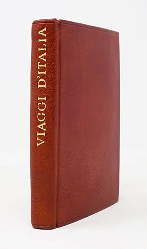
Viaggi d'Italia i pi� frequentati, e particolarmente da chi viaggia per le Poste, le quali si distinguano dalla presente figura
Published by [Florence], 1780
Manuscript / Paper Collectible First Edition Signed
Hardcover. Condition: Near fine. First. A collection of hand-colored. manuscript maps of Italy. [Florence, ca. 1775-1800.] Small octavo in 1s and 2s (5 1/8" x 3 7/16", 131mm x 87mm). [Full collation available.] With 15 hand-colored manuscript folding maps. Bound in russet morocco in 1968 by "SE" (signed blind on the rear fore turn-in). Single blind fillets top-and-bottom running right round the book, from the turn-ins along the boards across the spine. On the spine, title gilt. All leaves mounted on guards. Very slightest rubbing to the fore-corners. Spine sunned. Some tanning the edges of the leaves. Many folds strengthened or repaired (all guards modern). One incorrect title (map 4, Viaggio da Firenze a Roma has been corrected in early manuscript to read instead "a Bologna" (per the table of contents and the map). A shelfmark (101/20) at the upper edge of the title-page. Inkstamps of the Admiralty Office Library to the title-page and to the verso of the final map. As a system of posting or staging -- traveling via established routes with designated points for stopping and changing horses -- developed in Europe, travelers could move much more quickly and safely than before. Indeed, this is the beginning of the shift from traveler to tourist: the local explorer, keen to see the world but not with any unnecessary discomfort. Small collections of maps such as the present item became part of the necessary equipage of these tourists. Reflecting the most frequent routes of the time (not dissimilar to those taken even now), the maps are for Italy north of Rome, with the exception of the Rome-to-Naples map. The maps are beautifully if simply drawn and colored, but quite precise, with accurate compasses and a consistent scale of about 2mm to the mile. These will have found their way into the hands of wealth Grand Tourists; this one, perhaps, into the hands of an Englishman. Although these collections were written and colored by hand, they are not exactly unique; in the libraries of Europe and elsewhere similar volumes exist. The manuscript likely emerged from the workshop of the Giachi family of Florence (cf. Biblioteca Nazionale Centrale Firenze, Fondo Naz. II_XI_4 and II-XI_76; the former is signed by Antonio Giachi). In the closing decades of the XVIIIc they specialized in the production of these little pocket guides, usually with about 15 maps, as here. Errors, such as the erroneous title of map 4 or the misspelling of "medesime" as "mdesime" on line 5 of 11v (p. 2), suggest an exemplar copied by scribes in the workshop. Lord Wardington (Christopher Pease, 1924-2005; bought at his sale, Sotheby's London, 9 May 2006, lot 113) was an avid collector of maps and atlases at his home in Oxfordshire, Wardington Manor. A stock-broker by trade, he was a bibliophile by nature: he was the first chair of the Friends of the British Library. In 2004 a fire ravaged the house, and a human chain of villagers bore his books to safety. He was a captain in the Scots Guards stationed in Italy in WWII, and so the present collection must have had no little significance to him. Perhaps he purchased after its deaccession from the Admiralty Office Library, which in addition to records related to the British navy also held material related to travel and exploration.
-
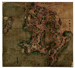
Oh-Sumi-Satsuma-Ryougoku-no Zu .
Published by Matsudaira Ohsumi, 1690
Seller: H�nersdorff Rare Books ABA ILAB, London, United Kingdom
Seller Rating:
Map First Edition
No Binding. Condition: Good. No Jacket. 1st Edition. (JAPAN - Kagoshima peninsula). Oh-Sumi-Satsuma-Ryougoku-no Zu . [Kagoshima ? c1690] Coloured manuscript navigational map painted on paper (99.3 x 109cm ) with landscape and coastlines in coloured pictorial relief of blue, green and grey; charting distances between fortified towns, and nautical miles from ports to neighbouring islands in red; original calligraphic title and seal still visible in top left margin; lower left margin with calligraphic ownership signature for the daimyo Matsudaira Ohsumi-no-kami of the Shimazu clan, chief of the Osumi domain; mounted on paper; artist unknown. Folded in modern blue paper cover on soft cardboard with title inscription repeated. A fine manuscript map of the provinces of Satsuma and Osumi drawn up for its feudal lord, the daimyo Matsudaira Ohsumi-no-kami of the Shimazu clan, probably in order to provide geographical information of his large and politically important domain to the Shogunate which ordered each feudal lord to furnish a map of his fief, as a form of indirect control. The present map may be a copy of the original sent to the shogun. Japan had about 300 daimyo during this period with greatly varying sizes of territory, so that the map of the rich trading southwestern peninsula would have been of special interest to the government. The port city of Kagoshima became the capital of Satsuma province, the feudal territory of the powerful Shimazu clan which also controlled the Osumi domain. Such manuscript maps later provided the basis for a new map of Japan, known as the Genruko Map , completed in 1702. Charted are land and sea routes between the main castle towns and ports of the peninsula, the distances between them and the neighbouring islands. Reference is made to : Yakushima in the south, one of the Osumi islands (famous for its cedarwood - 135 km from Kagoshima), in the west, to the [Koshikijima] islands (not named - 40km from Kagoshima), to the north to : Tanegashima, another Osumi island (known as a historic landing point for the introduction of European firearms to Japan - 115km from Kagoshima), and to the Amakusa islands off the west coast of Kyushu, also ruled by the Shimazu clan during the Edo period (135 km from Kagoshima). An interesting provenance; the powerful daimyo Matsudaira-Ohsumi-no-Kami, chief of Osumi domain, had an annual rice yield of 600,000 koku (- see Kyoto University Economic Review, volume II, 1927, page 45). Repairs to sectional folds, corners & edges; mounted on paper. Generally well preserved.
-
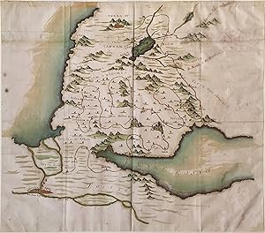
Manuscript map of the Holy Land, northern Egypt, and parts of the Arabian Desert
Manuscript / Paper Collectible
No binding. Condition: Fine. MANUSCRIPT map (19 1/4 x 22 inches) of the Holy Land, northern Egypt, and parts of the Arabian Desert, probably early 18th century; pencil, ink, and watercolor on faux vellum with horizontal and vertical folding creases (8 segments) and no mounting guard; pencil grid visible in upper left and rights quadrants. Condition: excellent with no visible flaws; traces of mounting guard visible on verso; upper portion of the map appears glued on (see non-aligning chain lines). Italian manuscript map depicting the 40 Stations of the Exodus, from Israel's Flight from Egypt (Raamses) to the Entry into Canaan. The chronology includes the Crossing of the Red Sea and the 11th Station at Mount Sinai. Note the perspectival tour de force applied to fit the course of the Nile (archaic) and the Red Sea in the lower half of the sheet. In addition to Cairo (identified in a moral cross-reference as "Babylon of Egypt") and Jerusalem, the unidentified cartographer identifies the Land of Goshen, the Desert of Edom in Transjordan, the Sinai Peninsula, as well as the unsurveyed Kingdom of Moab, and the enemy territory of the Amalekites.
-
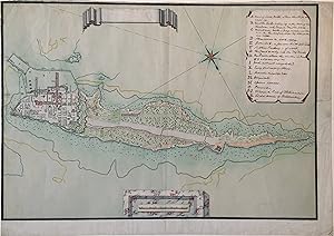
No binding. Double-page MANUSCRIPT map (18 � x 27 � inches) of Kotlin Island in the Baltic Sea, ca. 1730 or later; pen, ink, and watercolor on Dutch paper likely from the Herderskind Mill of Cornelis and Jacob Honig in Zaandijk (Strasburg lily in mannerist cartouche countermarked "C&I HONIG"); map includes 8-point compass rose, empty title cartouche with scroll elements, trompe-l'oeil legend, and scale in rectangular cartouche with marbling. Condition: excellent with limited or no foxing; left and upper margins cut; unidentified collector s stamp in red ink in lower right quadrant on verso. Provenance: collection of Sir Albert Richardson (1880-1964). Very attractive plan of Kotlin Island and Kronstadt at the head of the Gulf of Finland, with English annotations in upper right cartouche ranging from the location of the officers' houses (N) to the Lighthouse of Tolbukhin (R). Situated in the East of the longitudinal island, the Tolbukhin or Tolbaakin Lighthouse first opened in 1719. As the oldest lighthouse in Russia, it was of paramount importance in the military and naval development of Kronstadt which was founded by Peter the Great as early as 1704 to close access to the adjacent capital of St. Petersburg. One of Kronstadt's first governors was the Royal Scots Navy Officer Thomas Gordon who, refusing to take an oath of abjuration to King George I, resigned his commission and joined the Russian Navy in 1717. He held the position on Kotlin Island from 1727 until his death in 1741 and it is tempting to connect the present map with his tenure or its immediate aftermath.

![Seller image for R�gi Kalotaszeg. [Ancient Kalotaszeg.] for sale by F�ldv�ri Books](https://pictures.abebooks.com/inventory/md/md31153491380.jpg)
![Seller image for [Suitte du journal depuis le d�part de Manille NIII 1755].1755. Manuscript of 24 pages, 6 printed maps on cardboard. for sale by Antiquariaat FORUM BV](https://pictures.abebooks.com/inventory/md/md31470483957.jpg)