Order Total (1 Item Items):
Shipping Destination:

Map of Mexico (18 results)
Skip to main search results
Product Type
- All Product Types
- Books (13)
- Magazines & Periodicals
- Comics
- Sheet Music
- Art, Prints & Posters
- Photographs
- Maps (5)
-
Manuscripts &
Paper Collectibles
Condition
- All Conditions
- New
- Used
Binding
Collectible Attributes
- First Edition (4)
- Signed
- Dust Jacket (1)
- Seller-Supplied Images (10)
- Not Printed On Demand
Seller Location
Seller Rating
-
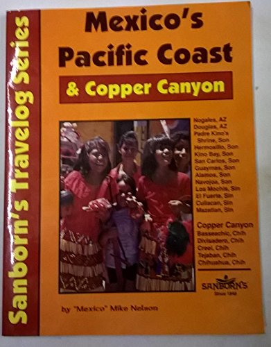
Mexico's Pacific Coast & Copper Canyon
Published by Wanderlust Pubns, McAllen, Texas, U.S.A., 1997
ISBN 10: 1878166107ISBN 13: 9781878166104
Book
Soft cover. Condition: Used/Good/Very Good. Dust Jacket Condition: Good/Very Good. Black & While Maps (illustrator). 2nd Edition. Showing Very Light Bumping Around The Corners, Very Light Rubbing. (Interior Appears New) The Pages Are Very Tight And Very Clean, We Found No Marks. Our Books Are Guaranteed And Ship The Day They're Sold; From Bellingham, Wa. In The Usa. "Recycle - Buy Used!". Book.
-
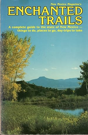
Enchanted Trails: A Complete Guide to the State of New Mexico-things to Do, Places to go, Day-Trips to Take
Published by New Mexico Magazine, Santa Fe, NM, 1980
ISBN 10: 0937206016ISBN 13: 9780937206010
Seller: Clausen Books, RMABA, Colorado Springs, CO, U.S.A.
Association Member: IOBA RMABA
Seller Rating:

Book
Wraps. Condition: Very Good. B&W Photographs/Maps/Graphs/Charts (illustrator). Textblock is gently aged, but clean and tight; b&w photographs and maps; Creased corners, reading creases along the spine, shelf scuffed edges. 249pp., including sources and index. Size: 8vo - over 7�" - 9�" tall. Paperback.
More buying choices from other sellers on AbeBooks
Used offers from US$ 8.50
Also find First Edition
-

Paperback. Condition: Very Good. Map, 81 North American Areas Plus Those In Mexico Listed By Daniel Galicia (illustrator). Reprinted From Ecology, Vol.22, No.1. Copyright Date: 1941 Sm Quarto, Jan. 1941, PP.100-110,
-
Geologic Map of the Glorieta Quadrangle, New Mexico
Published by New Mexico Bureau of Mines Socorro, New Mexico 1972, Socorro, New Mexico, 1972
Map (illustrator). Very Good condition,wraps.
-
Papers Presented at New Mexico Oil Conference; Univ of New MexicoBulletin Whole Number 343 Geological Series Vol. 5, No. 3
Published by Univ of New Mexico Press Albuquerque 1939, Albuquerque, 1939
Maps (illustrator). Very Good cond,light shelfwear,ex Atlantic Refining,wraps May 5th and 6th, 1939.
-
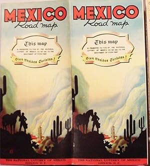
Mexico / Road Map / This Map Is Presented To You By The National / Lottery Of Mexico As An Ait To The / Enjoyment Of Your Visit / Bien Venidos Turistas!
Published by La Ensenanza Objectiva; Mexico City; pp.; ; Fine; nc/nd (1937), 1937
Map
No Binding. Condition: Fine. _____Single sheet, 17.5 x 23.5", printed on both sides and folded to 12 panels. _____ The exterior has two title panels, as well as text information of tourist interest._____ The section on the national lottery provides our 1937 date._____ There is also a four panel full color pictorial map of "Mexico City and Vicinity"._____ The vicinity stretches._____to include Vera Cruz, Oaxaca and Acapulco. _____ The interior is a simple map of the rudimentary road system within Mexico._____ There are tables of distances and road signs._____ With an altitude profile of the highway from Nuevo Laredo to Mexico City. _____ Illustrated on both side with monochrome photos. _____.
-
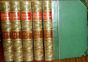
A System of Geography Popular and Schientific. Fullarton, 1841, Vol. 5 Only. Leather Binding
Published by A. Fullarton & Co., Edinburgh, 1841
Illustrated with 5 Folding Maps (2 with a Small View), Plus one Plate: The Great Square, Mexico. (illustrator). This volume covers China & North America, with the following double page maps (the first 2 with a small view): NORTH AMERICA; British North America; China; United States; & Mexico & Guatimala. CONDITION: Light rubbing to covers; occasional foxing. (PLEASE NOT THAT I HAVE FOR SALE VOLS: 1,2,4,5,&6). Size: 8vo.
-
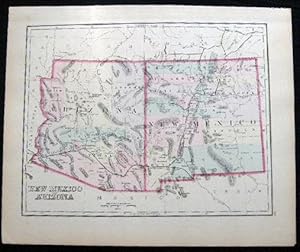
Original Hand-Colored Map of New Mexico and Arizona (and) Map of Mexico
Published by O.W. Gray & Son, Philadelphia, PA, 1882
First Edition
Not Bound. Condition: Very Good. Map. One sheet, printed with 2 maps, from the 1882 O.W. Gray National Atlas, New York Edition: New Mexico and Arizona (and) Mexico, with insets of The Isthmus of Tehuantepec Vera Cruz and Mexico to Vera-Cruz. With original hand-coloring in pastel tones and red border outlining. Approx. 14 3/8" x 17 1/4" overall size; a little even toning to the paper, margins with a little soiling, spotting; in very good condition.
-
Los Mayas del Sur y sus Relaciones con los Nahuas Meridionales : VIII Mesa redonda, San Cristobal Las Casas, Chiapas.
Published by Sociedad Mexicana, Mexico, D.F., 1961
orig.wrappers. Condition: Unopened. Some rubbing. VG. 2 folding maps, 2 charts. (illustrator). 24x16cm, 341 pp. Contains 31 papers. Includes: Esboco de geografia fisica humana de Chiapas;Contribucion a la etnozoologia maya de Chiapas; The Archaeological sequence at Chiapas de Corzo; A prolongation of the preclassical period indicated by the ceramics of Santa Rosa, Chiapas; La secuencia arqueologica en el Istmo de Tehuantepec; Archaeological reconnaissance in the Chiapas highlands; Chiapas-Guatemala relationships; Notas sobre algunas ruinas todavia sin explorar; Sobre algunas relaciones de la familia mangue; Linguistica tzeltal-tzotzil; Conquista y colonizacion de Chiapas; Huixteco (maya tzotzil) place-names; Nombres de lugares en chol ( maya); Sociologia historica de Ciudad Real; ; El arte de los Altos de Chiapas; El complejo ladino en las Altos de Chiapas; etc.
-
Correlation of Cenozoic Sediments: Gulf of Mexico Outer Continental Shelf: Part 1: Galveston Area Offshore Texas Through Vermilion Area Offshore Louisiana (geologic Cross-section plates)
Published by US Department of the Interior, Washington DC, 1987
First Edition
Boxed. Condition: Very Good. Color Maps (illustrator). First Thus. A boxed set of 33 large color maps covering the Correlation of Cenozoic Sediments: Gulf of Mexico Outer Continental Shelf: Part 1: Galveston Area Offshore Texas Through Vermilion Area Offshore Louisiana (Texas-louisiana line). OCS Report MMS 87-0026. Scarce set of geologic and minineral maps for the recently Hurricane battered Gulf coast area near the Texas-Louisiana border. (boxed maps only) Size: 4to - over 9�" - 12" tall. Book.
-
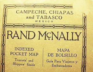
Rand McNally / Campeche / Chiapas And Tabasco / Mexico / Indexed Pocket Map / Tourists' And Shippers' Guide With / Railroads, Towns, Post Offices, / Lakes Rivers, Mountains, etc.
Published by Rand McNally & Co.; Chicago; 19 +(5) pp.; Wraps; VG; 1926/1926, 1926
Map
Soft cover. Condition: Very Good. _____ Single sheet, 28 x 21", printed on one side in full color and folded to 30 panels._____ Mounted into printed card covers, 6 1/2 x 4 1/8". _____ Titled "Rand McNally / Standard Map / Campeche / Chiapas and Tabasco", it shows the routes of three railroads: Cardenas & Rio Grijalva, Mexican National and United Railways of Yucatan. _____ The preliminary text section consists of locator index and tourist ads._____ The RM material is bi-lingual. _____ There is a circular 1/2" skinned spot from the upper forecorner of the front cover. _____.
-
New Mexico: A Guide To The Colorful State (Second Edition, With Errata At Front, And Large Color Folding Map The Land Of Enchantment: Official Road Map Of New Mexico, 1942", In Pocket At Rear)
Published by The University Of New Mexico Press, Albuquerque, 1945
Seller: Arroyo Seco Books, Pasadena, Member IOBA, Pasadena, CA, U.S.A.
Association Member: IOBA
Seller Rating:
Book
Hardcover. Condition: Very Good. No Jacket. Plates, Map Endpapers, Maps, Large Folding Map In Pocket At Rear (illustrator). 2nd Edition. Xxxvii, 458 Pp. Blue Cloth Lettered In Silver. Second Edition, With Errata Page At Front, And Very Large Folding Color Map "The Land Of Enchantment: Official Road Map Of New Mexico, 1942" In Pocket At Rear. The Map Is Scarce. Map Is Fine, Unworn And Brilliantly Colored. Book Has Light Wear; Ownership Signature Of Florence Pachter Schulkin, Who Served In The Women?S Army Corps At Los Alamos During The Manhattan Project; Bookstore Label Of Santa Fe Book And Stationery Co., Santa Fe, "Phone 58'.
-
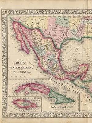
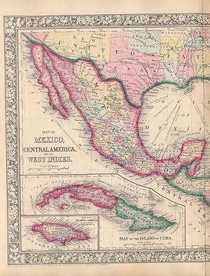
Map of Mexico, Central America, and the West Indies
Published by S. Augustus Mitchell, Jr., New York, 1860
Seller: Main Street Fine Books & Mss, ABAA, Galena, IL, U.S.A.
Association Member: ABAA ILAB MWABA
Seller Rating:
Map
Folio (23�" X 15�", image area 21�" X 13�"). Hand colored. Very good. Some age toning and minor soiling (mainly about edges), with single small inoffensive stain and single vertical fold (as issued). Wonderfully colored centerfold map of this large region, from the 1864 edition of "Mitchell's New General Atlas, Containing Maps of the Various Countries of the World, Plans of Cities, Etc." Two insets at upper right show "Map of the Bermuda Islands" and "Map of the Panama Railroad," while another pair at lower left show "Map of the Island of Cuba" and "Map of the Island of Jamaica." Much of the southern U.S. is visible as well: Part of California and New Mexico, all of Texas, Louisiana, Mississippi, Alabama, Georgia, Florida, Arkansas, Tennessee, both Carolinas and more partial states. Nicely colored, with sharp floral border.
-
Map of Mexico, Central America, and the West Indies
Published by S. Augustus Mitchell, Jr., New York, 1860
Seller: Main Street Fine Books & Mss, ABAA, Galena, IL, U.S.A.
Association Member: ABAA ILAB MWABA
Seller Rating:
Map
Folio (23�" X 15�", image area 21�" X 13�"). Hand colored. Very good. Lightly age toned, with single vertical fold (as issued). Bright and fetching centerfold map of this large region, from the 1864 edition of "Mitchell's New General Atlas, Containing Maps of the Various Countries of the World, Plans of Cities, Etc." Two insets at upper right show "Map of the Bermuda Islands" and "Map of the Panama Railroad," while another pair at lower left show "Map of the Island of Cuba" and "Map of the Island of Jamaica." Much of the southern U.S. is visible as well: Part of California and New Mexico, all of Texas, Louisiana, Mississippi, Alabama, Georgia, Florida, Arkansas, Tennessee, both Carolinas and more partial states. Handsomely colored, with fine decorative border.
-
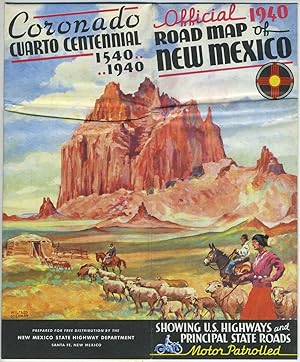
Official 1940 Road Map of New Mexico (Coronado Cuarto Centennial Issue) showing U.S. Highways and Principal State Roads
Published by New Mexico State Highway Department, Santa Fe, NM, 1940
Seller: Antipodean Books, Maps & Prints, ABAA, Garrison, NY, U.S.A.
Association Member: ABAA ANZAAB ESA ILAB
Seller Rating:

First Edition
Pamphlet / map. Condition: Otherwise very good condition. First printing. A pictorial map by Wilfred Stedman illustrated pamphlet / map that folds out to the full size of 20.5"x16.5". The top quarter of the pamphlet is slt. rippled.
-
War Centers of Mexico.
Published by San Francisco Ickelheimer Bros., Company, 1914, 1914
Seller: Franklin Gilliam :: Rare Books, A.B.A.A., Charlottesville, VA, U.S.A.
Seller Rating:
Single sheet, printed in color, 20 1/4 x 27 1/2 inches pp. Folded to 10 1/2 x 4 inches, plum-colored stiff printed wrappers A complimentary giveaway from an electrical and gas lighting contractor in San Francisco, Ickelheimer Bros. Company of 439 Sutter Street.On one side there is a color map of Mexico during the Mexican Revolution, showing the various armies and their positions, together with the blockading U.S. Navy off both coasts, listing the vessels by name. The map is haded "The Mexican Situation". The cartouche reads: "The Rand McNally New Commercial Atlas Map of Mexico" and is copyrighted 1914.On the second side which is divided into two parts, one part contains two columns of text outlining events in 19 and 1914 and listing all the U.S Navy vessels engaged. The second part contains a color map of North America.
-
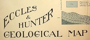
Eccles & Hunter / Geological Map Of South Eastern New Mexico
Published by Eccles & Hunter; no place; pp.; ; F-; 1920/nd, 1920
Map
No Binding. Condition: Near Fine. _____Single sheet, 38 x 24", printed on one side only._____This impressive map depicts in full color the occurence of 11 geological strata on the Texas border._____ No doubt in the interests of oil exploration. _____ Includes parts or all of several counties: Guadalupe, Lincoln, DeBaca, Chaves, Eddy, Curry, Roosevelt and Lea. _____ Towns include Carlsbad, Clovis and Tejon. _____ WorldCat (09/21) shows a single holding. _____ Folded to 12ths, presumably as issued._____Minor splits to the folds at the edge. _____.