Order Total (1 Item Items):
Shipping Destination:

Matthews Northrup (97 results)
Skip to main search results
Product Type
- All Product Types
- Books (78)
- Magazines & Periodicals (1)
- Comics
- Sheet Music
- Art, Prints & Posters
- Photographs
- Maps (18)
-
Manuscripts &
Paper Collectibles
Condition
Binding
Collectible Attributes
- First Edition (5)
- Signed
- Dust Jacket
- Seller-Supplied Images (43)
- Not Printed On Demand (75)
Free Shipping
Seller Location
Seller Rating
-

Designing and Developing Web Applications Using Microsoft� . Net Framework 4 : McPd Exam Ref 70-519
Published by Pearson Education, 2011
ISBN 10: 0735657262ISBN 13: 9780735657267
Book
Condition: Good. Used book that is in clean, average condition without any missing pages.
More buying choices from other sellers on AbeBooks
Used offers from US$ 6.73
-
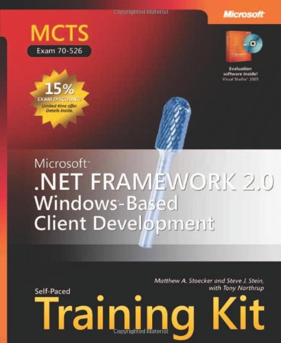
MCTS Self-Paced Training Kit (Exam 70-526): Microsoft .NET Framework 2.0 Windows-Based Client Development
Published by Microsoft Press, 2006
ISBN 10: 0735623333ISBN 13: 9780735623330
Book
Hardcover. Condition: Good. Connecting readers with great books since 1972! Used textbooks may not include companion materials such as access codes, etc. May have some wear or writing/highlighting. We ship orders daily and Customer Service is our top priority!.
More buying choices from other sellers on AbeBooks
New offers from US$ 40.49
Used offers from US$ 4.00
Also find Hardcover
-
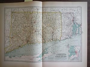
The Century Atlas, Map of Connecticut and Rhode Island (1897)
Published by The Century Co., 1897
Map
Map. Condition: Very Good. Authentic antique engraved color map by Matthews-Northrup Co. of the States of Connecticut and Rhode Island from the 1897 edition of the Century Atlas of the World. Includes inset of Newport Rhode Island. Plate size of approximately 10.375? x 14.785? on a page with dimensions of 13? x 17? Light age toning in margins not impacting plate. Center crease as issued; obverse blank. Most advanced Atlas of the times. Other maps from Atlas available. All items carefully packed to avoid damage from moisture and rough handling.
-
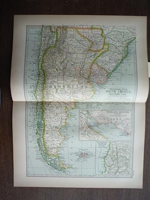
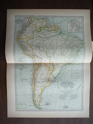
Map. Condition: Very Good. Authentic antique engraved color map by Matthews-Northrup Co. of South America, Southern Part from the 1897 edition of the Century Atlas of the World. Inset of Buenos Aires, Montevideo and Vicinity and of Valparaiso, Santiago and Vicinity. Plate size of approximately 10.375" x 14.785" on a page with dimensions of 13" x 17". ight age toning in margins not impacting plate. Center crease as issued; obverse blank. Most advanced Atlas of the times. Other maps from Atlas available. All items carefully packed to avoid damage from moisture and rough handling.
-

Free Niagara Classic Reprint
Published by Forgotten Books, 2018
ISBN 10: 1331897874ISBN 13: 9781331897873
Book
PAP. Condition: New. New Book. Shipped from UK. Established seller since 2000.
More buying choices from other sellers on AbeBooks
New offers from US$ 16.29
Used offers from US$ 13.79
Also find Softcover
-
Map. Condition: Very Good. Authentic antique engraved color map by Matthews-Northrup Co. of the State of Massachusetts Eastern Part from the 1897 edition of the Century Atlas of the World. Includes insert of Martha's Vineyard Island. Plate size of approximately 10.375" x 14.785" on a page with dimensions of 13" x 17". Light age toning in margins not impacting plate. Center crease as issued; obverse blank. Most advanced Atlas of the times. Other maps from Atlas available. All items carefully packed to avoid damage from moisture and rough handling.
-
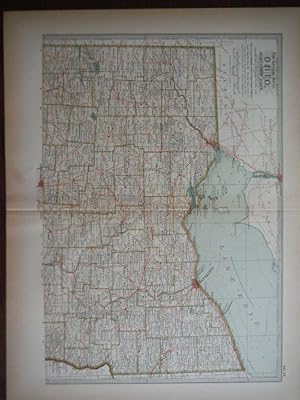
Map. Condition: Very Good. Authentic antique engraved color map by Matthews-Northrup Co. of the State of Ohio Northern Part from the 1897 edition of the Century Atlas of the World. Plate size of approximately 10.375? x 14.785? on a page with dimensions of 13? x 17? Light age toning in margins not impacting plate. Center crease as issued; obverse blank. Most advanced Atlas of the times. Other maps from Atlas available. All items carefully packed to avoid damage from moisture and rough handling.
-
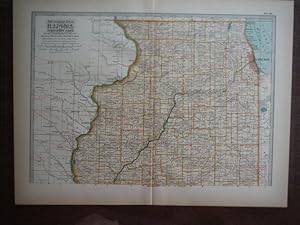
Map. Condition: Very Good. Authentic antique engraved color map by Matthews-Northrup Co. of the State Illinois, Northern Part from the 1897 edition of the Century Atlas of the World. Plate size of approximately 10.375? x 14.785? on a page with dimensions of 13? x 17? Light age toning in margins not impacting plate. Center crease as issued; obverse blank. Most advanced Atlas of the times. Other maps from Atlas available. All items carefully packed to avoid damage from moisture and rough handling.
-
The Century Atlas Map of the Dominion of Canada and Newfoundland (1897)
Published by The Century Co., 1897
Map
Map. Condition: Very Good. Authentic antique engraved color map by Matthews-Northrup Co. of the Dominion of Canada and Newfoundland from the 1897 edition of the Century Atlas of the World. Plate size of approximately 10.375" x 14.785" on a page with dimensions of 13" x 17". Light age toning in margins not impacting plate. Center crease as issued; obverse blank. Most advanced Atlas of the times. Other maps from Atlas available. All items carefully packed to avoid damage from moisture and rough handling.
-
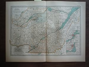
Map. Condition: Very Good. Authentic antique engraved color map by Matthews-Northrup Co. of Quebec from the 1897 edition of the Century Atlas of the World. Inset of Quebec and Vicinity and of Toronto and Vicinity. Plate size of approximately 10.375" x 14.785" on a page with dimensions of 13" x 17". Light age toning in margins not impacting plate. Center crease as issued; obverse blank. Most advanced Atlas of the times. Other maps from Atlas available. All items carefully packed to avoid damage from moisture and rough handling.
-
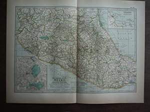
Map. Condition: Very Good. Authentic antique engraved color map by Matthews-Northrup Co. of Mexico, Central Portion from the 1897 edition of the Century Atlas of the World. Inset of the City of Mexico and Vicinity and of Veracruz. Plate size of approximately 10.375" x 14.785" on a page with dimensions of 13" x 17". Light age toning in margins not impacting plate. Center crease as issued; obverse blank. Most advanced Atlas of the times. Other maps from Atlas available. All items carefully packed to avoid damage from moisture and rough handling.
-
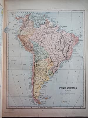
Map. Condition: Very Good. Authentic antique engraved color map by Matthews-Northrup Co. of South America from the 1897 edition of the Century Atlas of the World. Plate size of approximately 10.375" x 14.785" on a page with dimensions of 13" x 17". Light age toning in margins not impacting plate. Center crease as issued; obverse blank. Most advanced Atlas of the times. Other maps from Atlas available. All items carefully packed to avoid damage from moisture and rough handling.
-
The Century Atlas Map of South America, Northwest Part (1897)
Published by The Century Co., 1897
Map
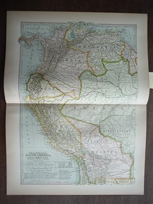
Map. Condition: Very Good. Authentic antique engraved color map by Matthews-Northrup Co. of South America, Northwest Part from the 1897 edition of the Century Atlas of the World. Plate size of approximately 10.375" x 14.785" on a page with dimensions of 13" x 17". Light age toning in margins not impacting plate. Center crease as issued; obverse blank. Most advanced Atlas of the times. Other maps from Atlas available. All items carefully packed to avoid damage from moisture and rough handling.
-

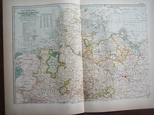
The Century Atlas Map of German Empire, Southwestern Part (1897)
Published by The Century Co., 1897
Map
Map. Condition: Very Good. Authentic antique engraved color map by Matthews-Northrup Co. of German Empire, Southwestern Part from the 1897 edition of the Century Atlas of the World. Plate size of approximately 10.375? x 14.785? on a page with dimensions of 13? x 17? Light age toning in margins not impacting plate. Center crease as issued; obverse blank. Most advanced Atlas of the times. Other maps from Atlas available. All items carefully packed to avoid damage from moisture and rough handling.
-
Map. Condition: Very Good. Authentic antique engraved color map by Matthews-Northrup Co. of German Empire, Northern Part from the 1897 edition of the Century Atlas of the World. Plate size of approximately 10.375? x 14.785? on a page with dimensions of 13? x 17? Light age toning in margins not impacting plate. Center crease as issued; obverse blank. Most advanced Atlas of the times. Other maps from Atlas available. All items carefully packed to avoid damage from moisture and rough handling.
-
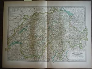
Map. Condition: Very Good. Authentic antique engraved color map by Matthews-Northrup Co. of Switzerland and Leichtenstein from the 1897 edition of the Century Atlas of the World. Plate size of approximately 10.375? x 14.785? on a page with dimensions of 13? x 17? Light age toning in margins not impacting plate. Center crease as issued; obverse blank. Most advanced Atlas of the times. Other maps from Atlas available. All items carefully packed to avoid damage from moisture and rough handling.
-
Map. Condition: Very Good. Original antique colored map of Maine by The Matthews-Northrup Co. from the Twentieth Century Peerless Atlas published by Crowell & Kirkpatrick in 1901, Plate dimensions 12" H x 9.5" wide. Includes inset of the City of Portland and Vicinity. Scale 1 inch equals 26 miles. Small closed tear along bottom edge not impacting plate. Other maps from this Atlas are listed and available. All items carefully packed to avoid damage from moisture and rough handling.
-
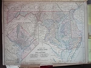
Matthews-Northrup Map of Maryland and Delaware (1901)
Published by Crowell & Kirkpatrick Co., 1901
Map
Map. Condition: Very Good. Original antique map of Maryland and Delaware by The Matthews-Northrup Co. from the Twentieth Century Peerless Atlas published by Crowell & Kirkpatrick in 1901, Plate dimensions 12.5" x 9.5" . No folds, tears or creases. Includes inset of the District of Columbia. Scale 1 inch equals 12 miles. On reverse side is a map of Virginia and West Virginia. Other maps from this Atlas are listed and available. All items carefully packed to avoid damage from moisture and rough handling.
-
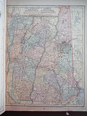
Map. Condition: Very Good. Original antique colored map of New Jersey by The Matthews-Northrup Co. from the Twentieth Century Peerless Atlas published by Crowell & Kirkpatrick in 1901, Plate dimensions 12" H x 9.5" wide. Includes inset of the Cities of Newark and Jersey City and Vicinity. Scale 1 inch equals 15 miles. Small closed tear along bottom edge not impacting plate. On reverse side is a map of New Hampshire and Vermont. Other maps from this Atlas are listed and available. All items carefully packed to avoid damage from moisture and rough handling.
-
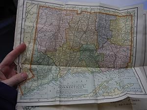
The Matthews-Northrup Up-to-Date Colored Map of CONNECTICUT (1898)
Published by Matthews-Northrup, 1898
Map
Map. Condition: Very Good. Original vintage Matthews-Northrup folded engraved map of Connecticut. Dimensions (11.75" W x 9.5" H). Eight folds. Contents clean and unmarked; small crease and chip along edge. Fold lines. Scale 1 inch = 8.5 Miles. Date 1898. All items carefully packed to avoid damage from moisture and rough handling.
-

The New Matthews-Northrup Global Atlas of the World at War
Published by The World Publishing Co., 1940
Book
Paperback. Condition: Fair.
-
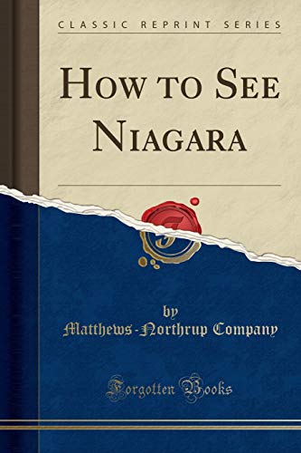
How to See Niagara Classic Reprint
Published by Forgotten Books, 2018
ISBN 10: 1333285744ISBN 13: 9781333285746
Book
PAP. Condition: New. New Book. Shipped from UK. Established seller since 2000.
More buying choices from other sellers on AbeBooks
New offers from US$ 19.04
-
The Matthews-Northrup Up-to-Date Map of Georgia: Indexed Vest-Pocket Series
Published by Matthews-Northrup, 1894
Stiffwraps. Condition: Good Plus. Fold-out map has some little tears.
-
MAPS INSIGNIA & WAR PLANES (illustrator). FAIR W/CIG BURN AT STAPPLED SPINE DIRTY & WORN OVERSIZE PB COVER TEARING AT BOTTOM OF SPINE PGS YELLOWED O/WISE ALL PGS PRESENT & CLEAN OF MARKS.
-
MAPS INSIGNIA & WAR PLANES (illustrator). FAIR W/CIG BURN AT STAPPLED SPINE DIRTY & WORN OVERSIZE PB COVER TEARING AT BOTTOM OF SPINE PGS YELLOWED O/WISE ALL PGS PRESENT & CLEAN OF MARKS.
-
MCPD Exam Ref 70-518
Published by Prentice-Hall, 2012
ISBN 10: 8120345541ISBN 13: 9788120345546
Book
Condition: Used. pp. 636.
More buying choices from other sellers on AbeBooks
Used offers from US$ 17.25
-

The MatthewsNorthrup Adequate TravelAtlas of the United States Classic Reprint
Published by Forgotten Books, 2018
ISBN 10: 0243191480ISBN 13: 9780243191482
Book
PAP. Condition: New. New Book. Shipped from UK. Established seller since 2000.
More buying choices from other sellers on AbeBooks
New offers from US$ 22.62
-
McPd 70-518 Exam Ref: Designing and Developing Windows Applications Using Microsoft .Net Framework 4
Published by Microsoft Press, 2011
ISBN 10: 0735657238ISBN 13: 9780735657236
Book
Paperback. Condition: Good. No Jacket. Pages can have notes/highlighting. Spine may show signs of wear. ~ ThriftBooks: Read More, Spend Less 1.2.
More buying choices from other sellers on AbeBooks
Used offers from US$ 23.37
-
Complete Handy Atlas Of The World And City Guide
Published by LEGARE STREET PR, 2022
ISBN 10: 1017770433ISBN 13: 9781017770438
Book Print on Demand
PAP. Condition: New. New Book. Shipped from UK. THIS BOOK IS PRINTED ON DEMAND. Established seller since 2000.
More buying choices from other sellers on AbeBooks
New offers from US$ 30.49
-
The Matthews-Northrup Up-to-Date Map of Pennsylvania. Published Indexed in Vets-Pocket Style.
Published by The Matthews-Northrup Co., Buffalo and New York, 1896
Seller: Jeffrey H. Marks, Rare Books, ABAA, Rochester, NY, U.S.A.
Seller Rating:

Folding county map in colors, indexed on verso. About 12 x 20 inches, folded to fit printed flexible red cloth portfolio, 5-1/4 x 2-1/2 inches.