Order Total (1 Item Items):
Shipping Destination:

Sanson D'abbeville, Nicholas 1600 1667 (20 results)
Skip to main search results
Product Type
- All Product Types
- Books (19)
- Magazines & Periodicals
- Comics
- Sheet Music
- Art, Prints & Posters
- Photographs
- Maps (1)
-
Manuscripts &
Paper Collectibles
Condition
- All Conditions
- New
- Used
Binding
- All Bindings
- Hardcover (5)
- Softcover
Collectible Attributes
- First Edition (2)
- Signed
- Dust Jacket
- Seller-Supplied Images (4)
- Not Printed On Demand
Free Shipping
Seller Location
Seller Rating
-

Europa vetus ex Connatibus Geographicis Nicolai Sanson
Published by Amsterdam: Johannes Covens and Cornelis Mortier, [ca. 1740], 1740
2 sheets joined (sheet size 21 x 24 7/8 inches; 15 3/8 x 23 3.5/8 inches to the neat line) full margins showing the plate mark. A fine engraved detailed map of Europe, the title within an elaborate and elegant cartouche upper left; original hand color in part (a little toned at the edges) An exceptional map of Europe by Covens and Mortier in a splendid condition. This map was originally made by Nicholas Sanson d Abbeville (1600-1667), the founder of the French School of Geography, a school that was unprecedented in its attention to precision and scientific detail and discarded much of the decorative embellishments of previous maps as irrelevant. Johannes Covens (1697-1774) and Cornelis Mortier (1699-1783) were the founders of the biggest cartographic publishing company of the eighteenth century.
-
L'Europe divisee suivant l'etendue de ses principaux Etats, subdivises en leurs principales Provinces
Published by Paris: 1738, 1738
2 sheets joined (sheet size 21 6/8 x 30 inches; 18 x 27 7/8 inches to the neat line), full margins showing the plate mark. A fine engraved detailed map of Europe, the title within a nicely ornamented Louis-XV-style cartouche upper right, scale within a small sober cartouche, the left part of the map is a kind of manual which gives some information on the scientific information the map provides in political geography, natural geography and astronomic geography; with original hand color in outline (spot on the upper middle margin, vertical fold marks, a little toned at the edges). A fine and very interesting political, natural and astronomical map of Europe. Gilles Robert de Vaugondy (1688-1766), also known as Le Sieur or Monsieur Robert, and his son, Didier Robert de Vaugondy (c.1723-1786), were leading mapmakers in France during the 18th century. In 1757, they published The 'Atlas Universel' in which they integrated older sources with more modern maps. This dialogue between old and new is also suitable for this map, as it is originally made by Nicholas Sanson (1600-1667), who was the founder of the French school of cartography.
-
L'Europe divisee suivant l'estendue de les principaux Estats subdivises en leurs principales Provinces
Published by Paris: H. Jaillot, 1684, 1684
2 sheets joined (sheet size 25 x 36 4/8 inches ; 21 5/8 x 35 inches to the neat line), full margins showing the plate mark. A fine engraved detailed map of Europe, the title as a running headline and within an extremely elaborate allegorical rococo cartouche, showing the arms of Le Grand Dauphin, Louis de France (1661-1711), detailed scale within a decorative cartouche lower right, with original hand color in outline (light fold marks, a little toned at the edges). A fine and attractive map from a later issue of Jaillot's 'Atlas Nouveau'. The Frenchman Alexis-Hubert Jaillot (1632-1712) was the most important atlas compiler and publisher of the last quarter of the seventeenth century. The great fire of 1672 which destroyed the Blaeu empire, was his opportunity to take over this part of the market. He and Nicolas Sanson (1600-1667), the founder of the French School of Geography, had a working relationship which ended by the end of the 1670s, this led to Jaillot developing his own series of atlases. Due to his tremendous importance and efforts, Jaillot was given the title of Geographe du Roy by Louis XIV The 'Atlas Nouveau' was the result of the intense collaboration between Jaillot and the Sanson family. Shirley T-Jai - 1a.
-
Single sheet engraved map with full margins, original hand-color in outline (17 x 22 � inches sheet; 26 � x 32 inches framed) A fantastic uncolored map depicting one of the earliest views of the World. This map was created by one of the single most important French cartographers of the 17th century, Nicholas Sanson D'Abbeville. This innovative approach to mapmaking redefined commercial cartography over the next 50 years and signal the beginning end of the Dutch domination over trade. Sanson's noteworthy double hemisphere map of the world featuring his first depiction of the Island of California, using a model for the shape, which would be known as the first Sanson model. The map also provides a good look at the Great Lakes of North America, a region for which Sanson's regional maps would become the most advanced depiction of the cartography of the region for the next 30 years. It is one of the first maps to distinguish the Great Lakes with Lac Superior first named here. Lake Michigan, here called Lac des puans (lake of evil smells), is also introduced here. All five of the Great Lakes were not named until Sanson's 1656 map of New France. Neither Tasmania or New Zealand is shown. A faint outline of Terra Magellanica appears in the south reflecting the uncertainty of the time. Australia is only partially shown, and is labeled Beach after Marco Polo, with place names on the south and west coasts reflecting the Dutch discoveries as they pursued the East Indian spice trade. The map is typical of Sanson's "scientific" style of cartography with no decorative elements. The map depicts a curious northwest Coast of America, separated from California by an unnamed strait a curious omission for someone as meticulous as Sanson. This NorthWest Coast would disappear from his subsequent maps. It was published in conjunction with Pierre Mariette (father and son), who published many of Sanson's work after 1645. For more information on this map, or a warm welcome to see other maps and books of our collection at 72nd Street NYC, please contact Natalie Zadrozna.
-
Single sheet (18 x 23 4/8 inches; 16 x 22 4/8 inches to the neat line). Double-page engraved map of Asia with original hand-colour in outline (a little browned, central vertical crease). A fine and very decorative map by Nicholas Sanson. The Frenchman Nicholas Sanson d'Abbeville (1600-1667) was the founder of the French School of Geography, a school that was unprecedented in its attention to precision and scientific detail and discarded much of the decorative embellishments of previous maps as irrelevant. From Sanson's time in the second half of the seventeenth century until the latter part of the eighteenth century, French geographical conceptions were more influential than those put forward by any other nation. This map gives a nice impression of Spain during its golden age.
-
Les Deux Pole Arctique ou Septentrionale, et Antarctique ou Meidionale [ ]
Published by Paris: 1657., 1657
Single sheet, full margins, original hand-color in outline (17 x 22 � inches sheet; 26 � x 32 inches framed) An attractive double hemisphere map by "the Father of Cartogrpahy", Nicholas Sanson D'Abbeville. This map is based on the polar projections so as to include the northern and southern thirds of the world. The North Pole is found connected to Greenland and Spitzbergen but there is little other detailed coastline in the polar area. Europe, Russia and Canada are delineated. The South Pole is based on the great unknown Southland of Magellan. The most southern tip of South America is shown, and a large land mass ("Terra Incognita") which encompasses the whole of the hemisphere, but nothing else, showing the limited extent of knowledge of these extreme latitudes. Extraordinarily enough, though, the southern projection, which shows little more than the outline of a vast landmass 'Australe et Incogneue', roughly corresponding to Antarctica as we know it today, long before any of it was discovered. Maps by Sanson in original colour are rare, here with a colored outline. Nicolas Sanson (1600-1667) French cartographer who established the first great cartographic dynasty in France. He was tutor to Louis XIV. Sanson published over 300 maps and was a founder of the French school of mapmakers, at a time when the leadership in European cartography passed from the Low Countries to France. For more information on this map, or a warm welcome to see other maps and books of our collection at 72nd Street NYC, please contact Natalie Zadrozna.
-
Atlas Portatif et Nouveau du Voyageur pour les Dix-Sept Provinces des Pais-Bas. Avec la Description Geographique & une Table, pour trouver facilement les villes , &c. (bound at the end) Nieuwe Zak-Atlas voor de Reizigers door de gezamentlyke Nederlanden.( with decorative alternate title page) Le Th��tre de la guerre avec tous les campemans des arm�es.dans le XVII Provinces du Pais-Bas .
[1] Amsterdam, chez Pierre Mortier , s.d. ( ca. 1700 ) , typographical title printed in red & black + general map + (24) pp ( description) + division map + 33 maps + 2 engraved scale plates + 40 pp (index) + 8 pp ( index addenda) . [2] (dutch title) Nieuwe Zakatlas, Amsterdam, by Covens en Mortier, 1739, 24 pp. Bound before [1] & [2] is a double page engraved title page '' Le Th��tre de la guerre.'', s.d. Amsterdam, chez Covens & Mortier. In-8�, 18,5 x 11,5 cm, all 35 maps are double page and with fine contemporary hand colouring. Bound in contemporary red coloured half roan, boards covered with marbled paper. Binding with some wear and loss of the red colouring. Interior very fine, stainless and with bright colours. Complete and very attractive copy of an early 18th c. pocket atlas of the 17 Provinces of the Netherlands (the actual Benelux countries - Luxemburg, Belgium and the Netherlands), in a bi-lingual edition French and Dutch.
-
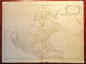
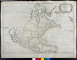
Amerique Septentrionale
Published by Paris: Chez l'Auteur Et chez Pierre Mariette rue S. Iacques a l Esperance, 1650, 1650
First Edition
SANSON D'ABBEVILLE, Nicholas (1600-1667). Amerique Septentrionale Par N. Sanson d'Abbeville Geog. du Roy A Paris Chez l'Auteur Et chez Pierre Mariette rue S. Iacques a l Esperance 1650. Avec privilege du Roy pour vingt Ans Single sheet (17 x 22 6/8 inches; 15 2/8 x 22 6/8 inches to the neat line; full margins showing the plate mark). Engraved map of North and Central America, showing the northeastern and southern coasts and territories in close detail, particularly New France and the Great Lakes, all of which are shown here for the FIRST TIME, the west coast extends as far north as as California, which is shown as an island, and New Mexico; the title appears within a fine rococo cartouche upper right, with lines of latitude and longitude numbered every 5 degrees, all with fine original colour in outline, on paper watermarked with Grapes, similar to Heawood 2428 with word Colonbier around grapes (central vertical crease, a bit browned, corners chipped with loss) Provenance: with Alta California Books, 7/66; from the important cartographical library of Warren Heckrotte, his sale, Rare Cartography, Exploration and Voyages, Part I, 29th October, 2015, lot 176 First edition, third issue. There are three states of the map: the first state, of which only two examples are known, which has no land to the north-west of California; the second state, also quite uncommon, adds coastline to the north and west and eliminates a few place-names north of California; the third state is the same as the second, except that Lake Ontario has been shaded to match the other Great Lakes. Sanson's "Amerique Septentrionale" is the most influential map of North America of the 17th-century. On it for the first time on a printed map are depictions of all five of the Great Lakes. "LANDMARK MAP OF NORTH AMERICA" (Burden) "In 1650 Sanson published his LANDMARK MAP OF NORTH AMERICA. It was drawn, with his usual care, using the sinusoidal projection which is sometimes known by the name Sanson-Flamstead. It is, perhaps, most important for being the first printed map to delineate the five Great Lakes in a recognisable form. Sanson's map was the first to name Lakes Superior and Ontario, and Lakes Erie and Huron, unnamed, appear in a more familiar form. Montreal, recorded here at the important junction of the R des Prairies, Ottawa River, and the St. Lawrence River, was chosen by Champlain in 1611 as the site for a trading post, but it was not until 1642 that it became occupied year round. The waters of the north illustrate the continued hope of a North West Passage. The majority of the cartography of New France was new and would remain as the most accurate until seperseded by Coronelli in 1688. The east coast of North America does not bear much detail, but one interesting feature is the location of "Novelle Amsterdam" on an island some distance off shore. The reference to N. Suede is the first on a printed map of the Swedish colony founded in 1638. The south and south-east are largely similar to those of the Hondius, America Septentrionalis, 1636. "To the west S. Fe, Navajo, Apache, Taosij and others all appear for the first time. The first is incorrectly placed on the west bank of the Rio Grande, here again flowing to the south-west. These were the first advances in the geography of this region for some time. California as an island is of the Briggs type with some important alterations; Sanson introduces four placenames from the de Laet map of 1630, C. de Fortune, C. de Pinos, C. de S. Martin and C. de Galera" (Burden 294). Louis XIV, The sun King, King of France (1643 1715) had ruled his country and a large proportion of North America for a mere 7 years when Sanson created this magnificent map of his French Dominions there. His reign, principally from his great palace at Versailles, covered one of Frances most brilliant periods and Louis, the Sun King, remains the symbol of absolute monarchy of the classical age. However the beginning of his reign was fraught wi.
-
AMERIQUE SEPTENTRIONALE
Published by Edit� � Paris: Chez l'Auteur Et chez Pierre Mariette rue S. Iacques a l Esperance, 1650, 1650
Map
Pas de couverture. Condition: Tr�s bon. AMERIQUE SEPTENTRIONALE, SANSON D'ABBEVILLE, Nicholas (1600-1667), Peyrounin sculpt. Paris : Chez l'Auteur et chez Pierre Mariette, 1650. Mariette, Pierre-Jean, 1694-1774. Copper plate engraving, 43 x 57,5 cm, original outline color. The present example is state 3 of the map with Lake Ontario shaded.
-
L Europe en Plusiers Cartes, et en divers Traites de Geographie et d Histoire;. ses Empires, ses Peuples, ses Colonies, leurs Moeurs, Langues, Religions, Richesses,
Published by Paris: Chez l Autheur, 1683., 1683
"4 parts in one volume. 4to., (8 4/8 x 7 5/8 inches). Four letterpress title-pages, including one general title-page, four indexes (lacking double-page engraved title-page). 62 engraved double-page or folding maps, 14 with later hand-colour in outline (one or two with archival repairs to folds on versos, some inoffensive waterstaining to last few maps). Late 18th-century half calf, marbled paper boards, citron morocco lettering-piece on spine (corners worn, rubbed, hinges weak). Sanson s series of quarto atlases were originally published separately as "L Europe" in 1648 by Sanson s son, also Nicholas, who was tragically killed in the "Barricades" insurrection the same year, "L Asie" in 1652, "L Afrique" in 1656, and "L Amerique" 1657. The maps of America include: "Amerique Septentrionale", "Canada, ou Nouvelle France", "La Floride", "Mexico", Guadalajara", "Guatimala", "Les Isles Antilees", "Amerique MEridionale", "Terre Ferme de Grenade", "Guiane", "Le Perou", "Le Chili", "Le Bresil", "Le Paraguay" "Detroit de Magellan". Sanson published his first folio atlas in 1654, with 100 maps, engraved and printed by Pierre Mariette; each held the copyright to half of the maps which bear their separate imprints, and were issued progressively from 1630. Born in Abbeville, a town in the Picardy region of France, in 1600, Sanson was the most noted French cartographer in modern history. Mapmaker to Louis XIV, King of France, Sanson endowed his maps with the most recent geographical information as well as the finest and sharpest engraving of the period. His "Cartes Generales de Toutes les Parties du Monde" was the most important single product of French commercial cartography of the seventeenth century. Sanson sparked a renaissance in geographical endeavor in his native country, which had not been a major player on the international cartographic stage since the great Oronce Fin� in the sixteenth century. With this atlas, Sanson laid the foundations of French domination in map production, initiating the so-called "French school of cartography," a school that was unprecedented in its attention to precision and scientific detail and discarded much of the decorative embellishments of previous maps as irrelevant. From Sanson's time in the second half of the seventeenth century until the latter part of the eighteenth century, French geographical conceptions were more influential than those put forward by any other nation. Phillips 494, Sabin 76712n; Shirley T.San 3a, 4a, 5a, 6a. Catalogued by Kate Hunter.".
-
L Europe en Plusiers Cartes, et en divers Traites de Geographie et d Histoire;. ses Empires, ses Peuples, ses Colonies, leurs Moeurs, Langues, Religions, Richesses,
Published by Paris: Chez l Autheur, 1683., 1683
"4 parts in one volume. 4to., (8 5/8 x 6 5/8 inches). Four letterpress title-pages, including one general title-page, four indexes. 62 engraved double-page or folding maps (maps of Italy and Turkey laid down to adjoining text leaves, some light soiling and spotting). Contemporary mottled calf (worn, joints weak). Provenance: with early ownership inscription of Joseph Bromehead (?1748-1826), writer of hymns, and curate of Eckington Derbyshire, on the title-page; and the early 20th-century inscription of "The Rentzes, Cairo, 8.1.53" on the recto of the first blank. Sanson s series of quarto atlases were originally published separately as "L Europe" in 1648 by Sanson s son, also Nicholas, who was tragically killed in the "Barricades" insurrection the same year, "L Asie" in 1652, "L Afrique" in 1656, and "L Amerique" 1657. The maps of America include: "Amerique Septentrionale", "Canada, ou Nouvelle France", "La Floride", "Mexico", Guadalajara", "Guatimala", "Les Isles Antilees", "Amerique MEridionale", "Terre Ferme de Grenade", "Guiane", "Le Perou", "Le Chili", "Le Bresil", "Le Paraguay" "Detroit de Magellan". Sanson published his first folio atlas in 1654, with 100 maps, engraved and printed by Pierre Mariette; each held the copyright to half of the maps which bear their separate imprints, and were issued progressively from 1630. Born in Abbeville, a town in the Picardy region of France, in 1600, Sanson was the most noted French cartographer in modern history. Mapmaker to Louis XIV, King of France, Sanson endowed his maps with the most recent geographical information as well as the finest and sharpest engraving of the period. His "Cartes Generales de Toutes les Parties du Monde" was the most important single product of French commercial cartography of the seventeenth century. Sanson sparked a renaissance in geographical endeavor in his native country, which had not been a major player on the international cartographic stage since the great Oronce Fin� in the sixteenth century. With this atlas, Sanson laid the foundations of French domination in map production, initiating the so-called "French school of cartography," a school that was unprecedented in its attention to precision and scientific detail and discarded much of the decorative embellishments of previous maps as irrelevant. From Sanson's time in the second half of the seventeenth century until the latter part of the eighteenth century, French geographical conceptions were more influential than those put forward by any other nation. Phillips 494, Sabin 76712n; Shirley T.San 3a, 4a, 5a, 6a. Catalogued by Kate Hunter.".
-
Cartes Generales de Toutes les Parties du Monde.
Published by Paris: The Author and Pierre Mariette, 1658 [but 1659]., 1659
Book
Hardcover. Condition: Very Good. Folio (17 x 12 4/8 inches). Title-page with woodcut arms, letterpress table of contents. 113 fine double-page engraved maps with beautiful original colour in outline (map of Germania Antiqua waterstained at outer edge just affecting image). 19th-century quarter French sheep, marbled paper boards (extremities scuffed). Provenance: contemporary consecutive numbering to the versos of most maps. Those maps relating particularly to the Americas are: three world maps "Mappe-Monde,." 1651 one of the earliest obtainable maps to show the 5 Great Lakes, "l'Hydrographie ou description de l'Eau" 1652, "Harmonie ou Correspondance du Globe." 1650, "Orbis vetus, et orbis vetris." 1657 (each map showing California as an island and the "Beach" peninsula, "Amerique Septentrionale" 1650, "Le Canada, ou Nouvelle France." 1656, Mexique ou Nouvelle Espagne" 1650, "Le Nouvelle Mexique, et la Floride" 1656, "Les Ilse Antilles ." 1656, "Amerique Meridionale" 1650, "Terre Ferme" 1656, ".Guinane et Caribane." 1656, "Le Perou" 1656, "Le Chili" 1656, "Le Bresi" 1656, "Le Paraguayr, Le Chili, La Terre, et les Isles Magellanicques" 1656, "Les deux Poles" 1657. The maps were compiled by Nicolas Sanson who first published his atlas in 1654, with 100 maps, and engraved and printed by Pierre Mariette; each held the copyright to half of the maps which bear their separate imprints, and were issued progressively from 1630. Born in Abbeville, a town in the Picardy region of France, in 1600, Sanson was the most noted French cartographer in modern history. Mapmaker to Louis XIV, King of France, Sanson endowed his maps with the most recent geographical information as well as the finest and sharpest engraving of the period. His "Cartes Generales de Toutes les Parties du Monde" was the most important single product of French commercial cartography of the seventeenth century. Sanson sparked a renaissance in geographical endeavor in his native country, which had not been a major player on the international cartographic stage since the great Oronce Fin� in the sixteenth century. With this atlas, Sanson laid the foundations of French domination in map production, initiating the so-called "French school of cartography," a school that was unprecedented in its attention to precision and scientific detail and discarded much of the decorative embellishments of previous maps as irrelevant. From Sanson's time in the second half of the seventeenth century until the latter part of the eighteenth century, French geographical conceptions were more influential than those put forward by any other nation. With this landmark atlas, Sanson all but single-handedly caused the center of cartographic innovation to shift from Holland to France. Phillips 4260 NMM 3, 271. Catalogued by Kate Hunter.
-
Cartes Generales de Toutes les Parties du Monde.
Published by Paris: The Author and Pierre Mariette, 1658 [but 1659]., 1659
Folio. (17 x 11 6/8 inches). Title-page with woodcut arms (dampstained), 3-page contemporary manuscript "Repertoir des Cartes de ce livre" (without letterpress table of contents). 85 FINE engraved double-page maps, including 10 folding, hand-coloured in outline, mounted on guards throughout (one or two early repairs, tears, stains and edges frayed to folding map of Gascony, last map of Ancient Greece stained and laid down on contemporary stock). Contemporary mottled calf, spine in seven compartments with six raised bands, morocco lettering piece in one, the others decorated with small gilt tools (scuffed and worn with loss to extremities). A fine composite atlas: the manuscript list of contents detailing the 75 maps of the modern world, including two world maps, with an additional ten maps of the old world, including one world map. With two maps of America: "Amerique Septentrionale" (1650), the first to show all five Great Lakes; and "Amerique Meridionale" 1650. The maps were compiled by Nicolas Sanson who first published his atlas in 1654, with 100 maps, and engraved and printed by Pierre Mariette; each held the copyright to half of the maps which bear their separate imprints, and were issued progressively from 1630. The maps in this Atlas date from 1632 "Carte Geographique des Postes qui traversent la France" by Melchior Tavernier, but are evenly dated from the late 1630s to 1659. Born in Abbeville, a town in the Picardy region of France, in 1600, Sanson was the most noted French cartographer in modern history. Mapmaker to Louis XIV, King of France, Sanson endowed his maps with the most recent geographical information as well as the finest and sharpest engraving of the period. His "Cartes Generales de Toutes les Parties du Monde" was the most important single product of French commercial cartography of the seventeenth century. Sanson sparked a renaissance in geographical endeavor in his native country, which had not been a major player on the international cartographic stage since the great Oronce Fin� in the sixteenth century. With this atlas, Sanson laid the foundations of French domination in map production, initiating the so-called "French school of cartography," a school that was unprecedented in its attention to precision and scientific detail and discarded much of the decorative embellishments of previous maps as irrelevant. From Sanson's time in the second half of the seventeenth century until the latter part of the eighteenth century, French geographical conceptions were more influential than those put forward by any other nation. With this landmark atlas, Sanson all but single-handedly caused the center of cartographic innovation to shift from Holland to France. Lloyd Arnold Brown, The World Encompassed, exh. cat. (Baltimore, 1952), n. 157; Rodney W. Shirley, The Mapping of the World (London, 1983), n. 390; Philip D. Burden, The Mapping of North America: A List of Printed Maps 1511-1670 (Rickmansworth, 1996), 375-6. Catalogued by Kate Hunter.
-
Cartes Generales de Toutes les Parties du Monde.
Published by Paris: Sanson and Pierre Mariette, 1658 [but 1659]., 1659
Folio. (17 x 12 6/8 inches). Title-page with woodcut arms, letterpress table of contents (very creased). 114 FINE engraved double-page maps, including 2 folding, hand-coloured in outline, mounted on guards throughout (one or two pale marginal). Contemporary mottled calf, spine in seven compartments with six raised bands, title gilt-lettered in one, the others decorated with small gilt tools (scuffed and worn with loss to extremities). A fine composite atlas, including four double-hemisphere world maps: "Mappe-Monde, ou Carte Generale du Monde" 1651, "L'Hydrographie ou Description de l'Eau" 1652, "Harmonie ou Correspondance du Globe." 1659, and "Orbis Vetus" 1657, each showing California as an island and a partial coastline of Australia with the "Beach" peninsula; and the fine map "Les Deux Poles Arctique." 1657 showing Canada, and "Australe Incogneue". Maps relating to America include the world maps and "Amerique Septentrionale" 1650 the first to show all five Great Lakes, "Le Canada, ou Nouvelle France" 1656, "Le Nouveau Mexique, et la Floride" 1656, "Mexique ou Nouvelle Espagne" 1650, "Les Isles Antilles" 1656, "Amerique Meridionale" 1650, "Terre Ferme" 1656, "Partie de Terre Ferme ou font Guine et Caribane" 1656, "Le Perou" 1656, "Le Chili" 1656, "Le Bresil" 1656, and "Le Paraguyr, Le Chili, La Terre, et Les Isles Magellanicques" 1656. Maps related to Australia are: "Asie" 1650, "Asia Vetus" 1650, and "Les Isles Philippines Molucques et de la Sonde" 1654 each show the west coast of Carpentaria. The maps were compiled by Nicolas Sanson who first published his atlas in 1654, with 100 maps, and engraved and printed by Pierre Mariette; each held the copyright to half of the maps which bear their separate imprints, and were issued progressively from 1630. The maps in this Atlas date from 1632 "Carte Geographique des Postes qui traversent la France" by Melchior Tavernier, but are evenly dated from the 1650s. Born in Abbeville, a town in the Picardy region of France, in 1600, Sanson was the most noted French cartographer in modern history. Mapmaker to Louis XIV, King of France, Sanson endowed his maps with the most recent geographical information as well as the finest and sharpest engraving of the period. His "Cartes Generales de Toutes les Parties du Monde" was the most important single product of French commercial cartography of the seventeenth century. Sanson sparked a renaissance in geographical endeavor in his native country, which had not been a major player on the international cartographic stage since the great Oronce Fin� in the sixteenth century. With this atlas, Sanson laid the foundations of French domination in map production, initiating the so-called "French school of cartography," a school that was unprecedented in its attention to precision and scientific detail and discarded much of the decorative embellishments of previous maps as irrelevant. From Sanson's time in the second half of the seventeenth century until the latter part of the eighteenth century, French geographical conceptions were more influential than those put forward by any other nation. With this landmark atlas, Sanson all but single-handedly caused the center of cartographic innovation to shift from Holland to France. Lloyd Arnold Brown, The World Encompassed, exh. cat. (Baltimore, 1952), n. 157; Rodney W. Shirley, The Mapping of the World (London, 1983), n. 390; Philip D. Burden, The Mapping of North America: A List of Printed Maps 1511-1670 (Rickmansworth, 1996), 375-6. Catalogued by Kate Hunter.
-
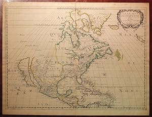
Amerique Septentrionale
Published by Paris: Chez l'Auteur Et chez Pierre Mariette rue S. Iacques a l Esperance, 1650, 1650
Single sheet (16 7/8 x 22 6/8 inches; 15 2/8 x 22 6/8 inches to the neat line; full margins showing the plate mark). Exceptionally fine engraved map of North and Central America, showing the northeastern and southern coasts and territories in close detail, particularly New France and the Great Lakes, all of which are shown her for the FIRST TIME, the west coast extends as far north as California, which is shown as an island, and New Mexico; the title appears within a fine rococo cartouche upper right, with lines of latitude and longitude, all with fine original color in outline, paper watermark (Coat of Arms, Heawood 673, but without c-k); one or two insignificant marginal stains. THE EXCEEDINGLY RARE FIRST STATE OF THIS SEMINAL MAP OF NORTH AMERICA, ONE OF ONLY TWO EXAMPLES KNOWN - THIS EXAMPLE, THE HECKROTTE COPY, DESCRIBED BY BURDEN in his bibliography: "The Mapping of North America." Sanson's "Amerique Septentrionale" is the most influential map of North America of the 17th-century. For the first time on a printed map are depictions of all five of the Great Lakes: in this early state Lake Ontario is indicated by boundaries which do not have engraved shading, in contrast to the other lakes portrayed; the latitudes at the right and left sides are numbered every 10 degrees; the longitudes along the lower edge are numbered every 10 degrees; the Azores are not yet depicted in the Atlantic; the short segment of the coastline running almost due west just to the north and west of the island of California in not present; in the northwest quarter there are to be found the place names of Anian, Quivira, and Nouvelle Albion; and Conibus is slightly to the east of where it appears in subsequent issues (Heckrotte, pp. 33-35). "LANDMARK MAP OF NORTH AMERICA" (Burden). "In 1650 Sanson published his landmark map of North America. It was drawn, with his usual care, using the sinusoidal projection which is sometimes known by the name Sanson-Flamstead. It is, perhaps, most important for being the first printed map to delineate the five Great Lakes in a recognisable form . Sanson's map was the first to name Lakes Superior and Ontario, and Lakes Erie and Huron, unnamed, appear in a more familiar form . Montreal, recorded here at the important junction of the R des Prairies, Ottawa River, and the St. Lawrence River, was chosen by Champlain in 1611 as the site for a trading post, but it was not until 1642 that it became occupied year round. The waters of the north illustrate the continued hope of a North West Passage. The majority of the cartography of New France was new and would remain as the most accurate until superseded by Coronelli in 1688. The east coast of North America does not bear much detail, but one interesting feature is the location of "Nouvelle Amsterdam" on an island some distance off shore. The reference to N. Suede is the first on a printed map of the Swedish colony founded in 1638. The south and south-east are largely similar to those of the Hondius, America Septentrionalis, 1636. "To the west S. Fe, Navajo, Apache, Taosij and others all appear for the first time. The first is incorrectly placed on the west bank of the Rio Grande, here again flowing to the south-west. These were the first advances in the geography of this region for some time. California as an island is of the Briggs type with some important alterations; Sanson introduces four placenames from the de Laet map of 1630: C. de Fortune, C. de Pinos, C. de S. Martin and C. de Galera. THE EXTREMELY RARE FIRST STATE OF THIS MAP, KNOWN ONLY IN TWO EXAMPLES, bears no coastlines to the west or north of California, only the names Anian, Quivera, Nouvelle Albion and Conibas appear above" (Burden). The Sanson family was revered among the foremost mapmakers in France for nearly a century. A leading exemplar of the French school of 17th century cartography, Nicholas Sanson is widely regarded as the founder of modern geography and it is generally held that the so-called "Great.
-
Cartes generales de la geographie ancienne et nouvelle ou les empires, monarchies, Royaumes
Published by Paris: The author and Pierre Mariette, 1675., 1675
First Edition
2 volumes in one. Folio (18 x 12 5/8 inches). Letterpress title-page to each volume and "Liste des Cartes", folding letterpress "Catalogues des Cartes Geographiques des Dieurs Jaillot Geographes Ordinaires du Roy" dated 1778 and with price-list in manuscript, bound at the beginning. 83 FINE folding engraved maps of the new and ancient world, with contemporary hand-colour in outline. Contemporary speckled calf (rebacked to style). First edition. Containing maps dating from 1652-1669, and particularly related to the Americas: three world maps "Harmonie ou Correspondance du Globe" (1659), "Mappemonde ou carte generale" (1669) (cf.Shirley 419), and " L'Hydrographie ou description de L'Eau" (1652) each showing California as an island, the last also one of the earliest obtainable maps to show the 5 Great Lakes; "Amerique Septentrionale" (1669), Burden's first state (404); "Le Canada, ou Nouvelle France" (1656); "Le Nouveau Mexique et la Floride" (1656), first state, engraved by Somer, and a cornerstone map of California and the Southwest, based on the Blaeu world map of 1648; "Mexicque ou Nouvelle Espagne" (1656); "Les Isles Antilles" (1656); "Amerique Meridionale" (1669); "Terre Ferme ou sont les Governations, ou Gouvernemens de Terre Ferme, Cartagene, St. Marthe, Rio De la Hache, Venezuela, Nouvelle Andaluise, Popyan" (1656); "Partie de Terre Ferme ou sont Guiane et Caribane" (1656); "Le Perou et le course de la Rivre Amazone" (1656); "Le Chili" (1669); "Le Bresil" (1656); "Le Paraguay" (1668); "Le Terre et les Isles Magellaniques" (1668). The maps were compiled by Nicolas Sanson who first published his atlas in 1654, with 100 maps, and engraved and printed by Pierre Mariette; each held the copyright to half of the maps which bear their separate imprints, and were issued progressively from 1630. Born in Abbeville, a town in the Picardy region of France, in 1600, Sanson was the most noted French cartographer in modern history. Mapmaker to Louis XIV, King of France, Sanson endowed his maps with the most recent geographical information as well as the finest and sharpest engraving of the period. His "Cartes Generales de Toutes les Parties du Monde" was the most important single product of French commercial cartography of the seventeenth century. Sanson sparked a renaissance in geographical endeavor in his native country, which had not been a major player on the international cartographic stage since the great Oronce Fin� in the sixteenth century. With this atlas, Sanson laid the foundations of French domination in map production, initiating the so-called "French school of cartography," a school that was unprecedented in its attention to precision and scientific detail and discarded much of the decorative embellishments of previous maps as irrelevant. From Sanson's time in the second half of the seventeenth century until the latter part of the eighteenth century, French geographical conceptions were more influential than those put forward by any other nation. With this landmark atlas, Sanson all but single-handedly caused the center of cartographic innovation to shift from Holland to France. Philips 486. Catalogued by Kate Hunter.
-
Folio (17 4/8 x 12 4/8 inches). Letterpress title-page, Tables des Cartes (some light soiling). 94 FINE double-page engraved maps with original hand-colour in outline, all mounted on guards. Contemporary speckled calf (extremities scuffed). Provenance: partially obscured contemporary ownership inscription on the title-page, and notes to the Tables des Cartes; 18th-century engraved armorial bookplate of C.G. Lieven on the front paste-down. AN ATTRACTIVE COPY of a fine composite atlas.Those maps relating particularly to the Americas are: three world maps "Mappemonde ou carte generale" (1651) one of the earliest obtainable maps to show the 5 Great Lakes, "L'Hydrographie ou description de L'Eau" (1652), and "Harmonie ou Correspondance du Globe" (1651) each showing California as an island; "Amerique Septentrionale" (1650); "Le Canada, ou Nouvelle France" (1656); "Mexicque ou Nouvelle Espagne" (1656); "Les Isles Antilles" (1656); "Sainct Christophle" (no date); "Guadeloupe" (no date); "Martinique" (no date); "Amerique Meridionale" (1650); "Terre Ferme ou sont les Governations, ou Gouvernemens de Terre Ferme, Cartagene, St. Marthe, Rio De la Hache, Venezuela, Nouvelle Andaluise, Popyan" (1656); "Partie de Terre Ferme ou sont Guiane et Caribane" (1656); "Le Perou et le course de la Rivre Amazone" (1656); "Le Chili" (1669); "Le Bresil" (1656); "Le Paraguayr, le Chili, la Terre, et les Isles Magellanicques" (1656); "Les Deux Poles" 1657; and "Orbis Vetus.(1657). The maps were compiled by Nicolas Sanson who first published his atlas in 1654, with 100 maps, and engraved and printed by Pierre Mariette; each held the copyright to half of the maps which bear their separate imprints, and were issued progressively from 1630. Born in Abbeville, a town in the Picardy region of France , in 1600, Sanson was the most noted French cartographer in modern history. Mapmaker to Louis XIV, King of France, Sanson endowed his maps with the most recent geographical information as well as the finest and sharpest engraving of the period. His "Cartes Generales de Toutes les Parties du Monde" was the most important single product of French commercial cartography of the seventeenth century. Sanson sparked a renaissance in geographical endeavor in his native country, which had not been a major player on the international cartographic stage since the great Oronce Fin� in the sixteenth century. With this atlas, Sanson laid the foundations of French domination in map production, initiating the so-called "French school of cartography," a school that was unprecedented in its attention to precision and scientific detail and discarded much of the decorative embellishments of previous maps as irrelevant. From Sanson's time in the second half of the seventeenth century until the latter part of the eighteenth century, French geographical conceptions were more influential than those put forward by any other nation. With this landmark atlas, Sanson all but single-handedly caused the center of cartographic innovation to shift from Holland to France. Catalogued by Kate Hunter.
-
A FINE COMPOSITE ATLAS OF FRENCH AND DUTCH MAPS.
Published by [Paris and Amsterdam, ca 1640-1655]., 1655
Folio (17 2/8 x 12 4/8 inches). 19th-century French manuscript table of contents tipped-in at the beginning. 138 fine double-page engraved maps (some browning and light spotting, a few edges frayed). 19th-century plain linen (a bit worn, endpapers renewed). A fine composite atlas compiled before 1658 when Sanson's business partner Mariette issued the first French world atlas with the engraved title "Cartes Generales de Toutes les Parties du Monde". The majority of the maps are compiled by Nicolas Sanson who first published his atlas in 1654, with 100 maps, and engraved and printed by Pierre Mariette; each held the copyright to half of the maps which bear their separate imprints, and were issued progressively from 1630. These maps are supplemented by a large number of regional maps not available in Paris, but published in Amsterdam by Hondius, Jansson and Danckerts, demonstrating the close links between the two mapping centers of Europe: Paris and Amsterdam, each looking to the other to supply what they were unable to. The Dutch maps in this atlas include some important maps related to America: "Nova Virginiae Tabula", Virginiae partis australia, et Floridae partis.", and "Nova Anglia Novum Belgium et Virginia" by Hondius and Jansson. The map of the Magellan Straits "Freti Magellanici" is the very rare issue with the signature of Jodocus Hondius (1629) indicating that the map was bought on an early buying trip to Amsterdam. Other maps related to America are "Mappe-Mode." 1651, "L'Hydrographie ou Description de l'Eau" (1652), "Amerique Septentrionale" (1650, Burden 294, state 2), Boisseau's "Description de la Nouvelle France" (Burden 261, state 1), Hondius and Jansson's "Nova Hispania", Duval's "Isles d'Amerique dites Caribes.", Mariette's "Isle de Guadeloupe", and "Isle de Martinique", Sanson's "Amerique Meridionale", Jansson's "Venezuela" and "Peru", Duval's "La Guyane", Jansson's "Accuratissima Brasiliae Tabula" and "Chili". This, the most comprehensive French folio atlas of this date, contains an unprecedented number of maps of foreign countries, including a number that are extremely rare: Boisseau"s "Description de la Nouvelle France" (1643), in the first state, is the first printed map to illustrate and name all five Great lakes; and his map of Malta, Gozo & Comino (1645); Duval's "Isles d'Amerique dites Caribes", and "la Guyane"; and Sanson and Mariett'e own "Estats de l'Empire dess Turqs en Europe", "Description de la Tartarie", "Carte des Trois Arabies", "L'Inde", "Les Iles Philippines", their maps of the African regions, all early strikes showing fine plate-tone. Born in Abbeville, a town in the Picardy region of France, in 1600, Sanson was the most noted French cartographer in modern history. Mapmaker to Louis XIV, King of France, Sanson endowed his maps with the most recent geographical information as well as the finest and sharpest engraving of the period. His "Cartes Generales de Toutes les Parties du Monde" was the most important single product of French commercial cartography of the seventeenth century. Sanson sparked a renaissance in geographical endeavor in his native country, which had not been a major player on the international cartographic stage since the great Oronce Fin� in the sixteenth century. With this atlas, Sanson laid the foundations of French domination in map production, initiating the so-called "French school of cartography," a school that was unprecedented in its attention to precision and scientific detail and discarded much of the decorative embellishments of previous maps as irrelevant. From Sanson's time in the second half of the seventeenth century until the latter part of the eighteenth century, French geographical conceptions were more influential than those put forward by any other nation. With this landmark atlas, Sanson all but single-handedly caused the center of cartographic innovation to shift from Holland to France. Catalogued by Kate Hunter.
-
Cartes Generales de Toutes les Parties du Monde
Published by Paris: The Author and Pierre Mariette, 1658 [but 1665]., 1665
Folio (17 2/8 x 12 6/8 inches). Title-page with woodcut arms (laid down on contemporary stock), letterpress "Table des Cartes" (extensively repaired on verso). Double-page engraved "Mappemonde ou carte generale" (1651) (repaired on verso with missing text supplied in manuscript), and 130 maps, all hand-colored in outline and mounted on guards throughout (occasional light spotting, browning or marginal dampstaining, last map of Ancient Greece repaired on verso). Late 17th-century calf gilt (spine and corners with early restoration). Provenance: Maps numbered consecutively in a 17th-century hand. A comprehensive edition of Sanson's important work, containing a number of important maps pertaining to the Americas: "Mappemonde ou carte generale" (1651), "L'Hydrographie ou description de L'Eau" (1652), "Harmonie ou Correspondance du Globe" (1659) all showing California as an island; "Amerique Septentrionale" (1650), the first to show all five Great Lakes; "Le Canada, ou Nouvelle France" (1656); "Le Nouveau Mexique et la Floride" (1656); "Mexicque ou Nouvelle Espagne" (1656); "Les Isles Antilles." (1656); "Amerique Meridionale" (1650); "Terre Ferme ou sont les Governations, ou Gouvernemens de Terre Ferme, Cartagene, St. Marthe, Rio De la Hache, Venezuela, Nouvelle Andaluise, Popyan" (1656); "Partie de Terre Ferme ou sont Guiane et Caribane" (1656); "Le Perou et le course de la Rivre Amazone" (1656); "Le Chili" (1656); "Le Bresil" (1656); "Le Paraguayr, Le Chili, et Les Isles Magellanicques" (1656); "Les Deux Poles." (1657); and "Orbis Vetus." (1657). The maps in this Atlas date from 1632 "Carte Geographique des Postes qui traversent la France" by Melchior Tavernier through to 1665. The maps were compiled by Nicolas Sanson who first published his atlas in 1654, with 100 maps, and engraved and printed by Pierre Mariette; each held the copyright to half of the maps which bear their separate imprints, and were issued progressively from 1630. Born in Abbeville, a town in the Picardy region of France, in 1600, Sanson was the most noted French cartographer in modern history. Mapmaker to Louis XIV, King of France, Sanson endowed his maps with the most recent geographical information as well as the finest and sharpest engraving of the period. His "Cartes Generales de Toutes les Parties du Monde" was the most important single product of French commercial cartography of the seventeenth century. Sanson sparked a renaissance in geographical endeavor in his native country, which had not been a major player on the international cartographic stage since the great Oronce Fin� in the sixteenth century. With this atlas, Sanson laid the foundations of French domination in map production, initiating the so-called "French school of cartography," a school that was unprecedented in its attention to precision and scientific detail and discarded much of the decorative embellishments of previous maps as irrelevant. From Sanson's time in the second half of the seventeenth century until the latter part of the eighteenth century, French geographical conceptions were more influential than those put forward by any other nation. With this landmark atlas, Sanson all but single-handedly caused the center of cartographic innovation to shift from Holland to France. The index calls for 113 titles, but as was often the case more maps have been added to this copy at the time of purchase. Cf. NMM 3, 271. Catalogued by Kate Hunter.
-
Cartes g�n�rales de toutes les parties du monde. - Geographia Sacra ex Veteri, et Novo.
Published by Paris: Pierre Mariette, 1667, 1667
2 volumes. Folio (18 x 13 2/8 inches). 343 FINE double-paged engraved maps, most with original hand-colour in outline by Sanson, P. du Val, and M. Tavernier (a few maps a bit creased). Contemporary speckled calf (rubbed, extremities scuffed). Provenance: With the near contemporary ownership inscription of Guillelmi Detroyes dated 1686 on the front free endpaper, and manuscript numbering to verso of most maps. The maps were compiled by Nicolas Sanson who first published his atlas in 1654, with 100 maps, and engraved and printed by Pierre Mariette; each held the copyright to half of the maps which bear their separate imprints, and were issued progressively from 1630. The maps in this Atlas date from the late 1630s, but are evenly dated from the 1640s to 1667. They include the latest discoveries in the New World. 'Amerique sepentrionale', shows the Great Lakes for the first time; the map of New Mexico and Florida, introduced California as an island. South America is mapped in great detail, and a double hemisphere map is devoted to the two poles. Born in Abbeville, a town in the Picardy region of France, in 1600, Sanson was the most noted French cartographer in modern history. Mapmaker to Louis XIV, King of France, Sanson endowed his maps with the most recent geographical information as well as the finest and sharpest engraving of the period. His "Cartes Generales de Toutes les Parties du Monde" was the most important single product of French commercial cartography of the seventeenth century. Sanson sparked a renaissance in geographical endeavor in his native country, which had not been a major player on the international cartographic stage since the great Oronce Fin� in the sixteenth century. With this atlas, Sanson laid the foundations of French domination in map production, initiating the so-called "French school of cartography," a school that was unprecedented in its attention to precision and scientific detail and discarded much of the decorative embellishments of previous maps as irrelevant. From Sanson's time in the second half of the seventeenth century until the latter part of the eighteenth century, French geographical conceptions were more influential than those put forward by any other nation. With this landmark atlas, Sanson all but single-handedly caused the center of cartographic innovation to shift from Holland to France. Pastoureau Sanson-VD; Shirley T.SAN-2b. Catalogued by Kate Hunter.l64F4A.