Order Total (1 Item Items):
Shipping Destination:

Saxton, William Engraver: Kip, William (14 results)
Skip to main search results
Product Type
- All Product Types
- Books (1)
- Magazines & Periodicals
- Comics
- Sheet Music
- Art, Prints & Posters
- Photographs
- Maps (13)
-
Manuscripts &
Paper Collectibles
Condition
- All Conditions
- New
- Used
Binding
- All Bindings
- Hardcover
- Softcover
Collectible Attributes
- First Edition (13)
- Signed
- Dust Jacket
- Seller-Supplied Images
- Not Printed On Demand
Seller Location
Seller Rating
-
![Seller image for [Befordshire]. Bedford Comitatus olim pars Cathifuclanorum. for sale by Robert Frew Ltd. ABA ILAB](https://pictures.abebooks.com/inventory/md/md30894927370.jpg)
[Befordshire]. Bedford Comitatus olim pars Cathifuclanorum.
Published by LondonImpensis Georgii Bishop & Ioannis Norton ., 1610
Seller: Robert Frew Ltd. ABA ILAB, London, United Kingdom
Association Member: ABA ILAB PBFA
Seller Rating:

Map First Edition
Original uncoloured engraved map of Bedfordshire trimmed to neatline and backed onto 18th century laid paper. Map dimensions 27.5 x 33 cm, overall backing-sheet size 32 x 40 cm. Rather soiled along right hand margin (mainly to backing-sheet), small tears to lower margin of backing sheet with old paper repair to verso, a bit unevenly toned, small losses to lower right corner. An early decorative map of Bedfordshire engraved by William Kip based on the earlier maps by Elizabethan cartographer Christopher Saxton first published in the 1607 edition of William Camden's Britannia.* This example is from the first English edition of Camden's Britannia published in 1610, without any text on the verso. Embellished with compass rose and decorative cartouche. *Britannia, first published in 1586, was one of the most popular and influential books of the period. The work of the Elizabethan antiquarian, William Camden (1551-1623), it was a detailed historical and topographical description of Great Britain. Its patriotic sentiments, in particular, both appealed to and generated the growing sense of nationalism that was coursing through late Tudor / early Stuart society. Between 1607 and 1637, county maps engraved by William Kip and William Hole, and based largely on Saxton's surveys, were added. (Skelton, 6).
-
![Seller image for [Essex]. Essexia comitatvs, qvem olim trinobantes tenuerunt continens in se opida marcatoria. for sale by Robert Frew Ltd. ABA ILAB](https://pictures.abebooks.com/inventory/md/md30894930063.jpg)
[Essex]. Essexia comitatvs, qvem olim trinobantes tenuerunt continens in se opida marcatoria.
Published by LondonImpensis Georgii Bishop & Ioannis Norton ., 1610
Seller: Robert Frew Ltd. ABA ILAB, London, United Kingdom
Association Member: ABA ILAB PBFA
Seller Rating:
Map First Edition
Original uncoloured engraved map of Essex showing parts of London in bottom right corner, trimmed to neatline and backed onto 18th century laid paper. Map dimensions 28.5 x 36.5 cm, overall backing-sheet size 32 x 40 cm. Small losses near upper centre and bottom right corner, a bit toned overall and with a few trivial blemishes. An early decorative map of Essex engraved by William Kip based on the earlier maps by Elizabethan cartographer Christopher Saxton first published in the 1607 edition of William Camden's Britannia.* This example is from the first English edition of Camden's Britannia published in 1610, without any text on the verso. Embellished with decorative cartouche. *Britannia, first published in 1586, was one of the most popular and influential books of the period. The work of the Elizabethan antiquarian, William Camden (1551-1623), it was a detailed historical and topographical description of Great Britain. Its patriotic sentiments, in particular, both appealed to and generated the growing sense of nationalism that was coursing through late Tudor / early Stuart society. Between 1607 and 1637, county maps engraved by William Kip and William Hole, and based largely on Saxton's surveys, were added. (Skelton, 6).
-
![Seller image for [Durham]. Dunelmensis Episcopatus (qui comitatus est Palatinus) en olim pars Brigantvm. for sale by Robert Frew Ltd. ABA ILAB](https://pictures.abebooks.com/inventory/md/md30894930984.jpg)
[Durham]. Dunelmensis Episcopatus (qui comitatus est Palatinus) en olim pars Brigantvm.
Published by LondonImpensis Georgii Bishop & Ioannis Norton ., 1610
Seller: Robert Frew Ltd. ABA ILAB, London, United Kingdom
Association Member: ABA ILAB PBFA
Seller Rating:
Map First Edition
Original uncoloured engraved map of Durham trimmed to neatline and backed onto 18th century laid paper. Map dimensions 27.5 x 33 cm, overall backing-sheet size 32 x 40 cm. A few prominent brown patches, a bit toned overall, small plate-crack near centre of map, small losses to bottom corner. An early decorative map of Durham engraved by William Kip based on the earlier maps by Elizabethan cartographer Christopher Saxton first published in the 1607 edition of William Camden's Britannia.* This example is from the first English edition of Camden's Britannia published in 1610, without any text on the verso. Embellished with decorative cartouche, compass rose, and a se galleon. *Britannia, first published in 1586, was one of the most popular and influential books of the period. The work of the Elizabethan antiquarian, William Camden (1551-1623), it was a detailed historical and topographical description of Great Britain. Its patriotic sentiments, in particular, both appealed to and generated the growing sense of nationalism that was coursing through late Tudor / early Stuart society. Between 1607 and 1637, county maps engraved by William Kip and William Hole, and based largely on Saxton's surveys, were added. (Skelton, 6).
-
![Seller image for [Radnorshire]. Radnor Comitatus quem silvres olim Incolucrunt. for sale by Robert Frew Ltd. ABA ILAB](https://pictures.abebooks.com/inventory/md/md30894927364.jpg)
[Radnorshire]. Radnor Comitatus quem silvres olim Incolucrunt.
Published by LondonImpensis Georgii Bishop & Ioannis Norton ., 1610
Seller: Robert Frew Ltd. ABA ILAB, London, United Kingdom
Association Member: ABA ILAB PBFA
Seller Rating:
Map First Edition
Original uncoloured engraved map of Radnorshire trimmed to neatline and backed onto 18th century laid paper. Map dimensions 27 x 32 cm, overall backing-sheet size 32 x 40 cm. Minimal toning and spotting, generally very good. An early decorative map of Radnorshire engraved by William Kip based on the earlier maps by Elizabethan cartographer Christopher Saxton first published in the 1607 edition of William Camden's Britannia.* This example is from the first English edition of Camden's Britannia published in 1610, without any text on the verso. *Britannia, first published in 1586, was one of the most popular and influential books of the period. The work of the Elizabethan antiquarian, William Camden (1551-1623), it was a detailed historical and topographical description of Great Britain. Its patriotic sentiments, in particular, both appealed to and generated the growing sense of nationalism that was coursing through late Tudor / early Stuart society. Between 1607 and 1637, county maps engraved by William Kip and William Hole, and based largely on Saxton's surveys, were added. (Skelton, 6).
-
![Seller image for [Denbighshire]. Denbigh Comitatus pas olim Ordovicvm. for sale by Robert Frew Ltd. ABA ILAB](https://pictures.abebooks.com/inventory/md/md30894927366.jpg)
[Denbighshire]. Denbigh Comitatus pas olim Ordovicvm.
Published by LondonImpensis Georgii Bishop & Ioannis Norton ., 1610
Seller: Robert Frew Ltd. ABA ILAB, London, United Kingdom
Association Member: ABA ILAB PBFA
Seller Rating:
Map First Edition
Original uncoloured engraved map of Denbighshire trimmed to neatline and backed onto 18th century laid paper. Map dimensions 27 x 32 cm, overall backing-sheet size 32 x 40 cm. 13 cm split down middle, minimal toning and spotting. An early decorative map of Denbighshire engraved by William Hole based on the earlier maps by Elizabethan cartographer Christopher Saxton first published in the 1607 edition of William Camden's Britannia.* This example is from the first English edition of Camden's Britannia published in 1610, without any text on the verso. *Britannia, first published in 1586, was one of the most popular and influential books of the period. The work of the Elizabethan antiquarian, William Camden (1551-1623), it was a detailed historical and topographical description of Great Britain. Its patriotic sentiments, in particular, both appealed to and generated the growing sense of nationalism that was coursing through late Tudor / early Stuart society. Between 1607 and 1637, county maps engraved by William Kip and William Hole, and based largely on Saxton's surveys, were added. (Skelton, 6).
-
![Seller image for [Staffordshire]. Staffordi� Comitatvs pars olim cornauiorum. for sale by Robert Frew Ltd. ABA ILAB](https://pictures.abebooks.com/inventory/md/md30894927368.jpg)
[Staffordshire]. Staffordi� Comitatvs pars olim cornauiorum.
Published by LondonImpensis Georgii Bishop & Ioannis Norton ., 1610
Seller: Robert Frew Ltd. ABA ILAB, London, United Kingdom
Association Member: ABA ILAB PBFA
Seller Rating:
Map First Edition
Original uncoloured engraved map of Staffordshire trimmed to neatline and backed onto 18th century laid paper. Map dimensions 27 x 37.5 cm, overall backing-sheet size 32 x 40 cm. Smudged overall and with a bit of browning. An early decorative map of Staffordshire engraved by William Kip based on the earlier maps by Elizabethan cartographer Christopher Saxton first published in the 1607 edition of William Camden's Britannia.* This example is from the first English edition of Camden's Britannia published in 1610, without any text on the verso. Embellished with decorative cartouche and compass dividers. *Britannia, first published in 1586, was one of the most popular and influential books of the period. The work of the Elizabethan antiquarian, William Camden (1551-1623), it was a detailed historical and topographical description of Great Britain. Its patriotic sentiments, in particular, both appealed to and generated the growing sense of nationalism that was coursing through late Tudor / early Stuart society. Between 1607 and 1637, county maps engraved by William Kip and William Hole, and based largely on Saxton's surveys, were added. (Skelton, 6).
-
![Seller image for [Cardiganshire]. Cardigan Comitatus pars olim Dimetarvm. for sale by Robert Frew Ltd. ABA ILAB](https://pictures.abebooks.com/inventory/md/md30894923692.jpg)
[Cardiganshire]. Cardigan Comitatus pars olim Dimetarvm.
Published by LondonImpensis Georgii Bishop & Ioannis Norton ., 1610
Seller: Robert Frew Ltd. ABA ILAB, London, United Kingdom
Association Member: ABA ILAB PBFA
Seller Rating:
Map First Edition
Original uncoloured engraved map of Cardiganshire trimmed to neatline and backed onto 18th century laid paper. Map dimensions 27 x 32 cm, overall backing-sheet size 32 x 40 cm. 2 small (3 cm) cracks to plate, two brown spots to backing-sheet, minor toning. An early decorative map of Cardiganshire engraved by William Hole based on the earlier maps by Elizabethan cartographer Christopher Saxton first published in the 1607 edition of William Camden's Britannia.* This example is from the first English edition of Camden's Britannia published in 1610, without any text on the verso. The map is embellished by a compass rose, compass dividers, two decorative cartouches, and a sea galleon. *Britannia, first published in 1586, was one of the most popular and influential books of the period. The work of the Elizabethan antiquarian, William Camden (1551-1623), it was a detailed historical and topographical description of Great Britain. Its patriotic sentiments, in particular, both appealed to and generated the growing sense of nationalism that was coursing through late Tudor / early Stuart society. Between 1607 and 1637, county maps engraved by William Kip and William Hole, and based largely on Saxton's surveys, were added. (Skelton, 6).
-
![Seller image for [Brecknockshire]. Brecknoc comitatus pars olim Silurum. for sale by Robert Frew Ltd. ABA ILAB](https://pictures.abebooks.com/inventory/md/md30894923693.jpg)
[Brecknockshire]. Brecknoc comitatus pars olim Silurum.
Published by LondonImpensis Georgii Bishop & Ioannis Norton ., 1610
Seller: Robert Frew Ltd. ABA ILAB, London, United Kingdom
Association Member: ABA ILAB PBFA
Seller Rating:
Map First Edition
Original uncoloured engraved map of Brecknockshire trimmed to neatline and backed onto 18th century laid paper. Map dimensions 27 x 32 cm, overall backing-sheet size 32 x 40 cm. 2 cracks to plate in centre of map and one to bottom right, some light smudging and toning especially to backing-sheet. An early decorative map of Brecknockshire engraved by William Kip based on the earlier maps by Elizabethan cartographer Christopher Saxton first published in the 1607 edition of William Camden's Britannia.* This example is from the first English edition of Camden's Britannia published in 1610, without any text on the verso. *Britannia, first published in 1586, was one of the most popular and influential books of the period. The work of the Elizabethan antiquarian, William Camden (1551-1623), it was a detailed historical and topographical description of Great Britain. Its patriotic sentiments, in particular, both appealed to and generated the growing sense of nationalism that was coursing through late Tudor / early Stuart society. Between 1607 and 1637, county maps engraved by William Kip and William Hole, and based largely on Saxton's surveys, were added. (Skelton, 6).
-
![Seller image for [Flintshire]. Flint Comitatus quem ordovices olim Incolucrunt. for sale by Robert Frew Ltd. ABA ILAB](https://pictures.abebooks.com/inventory/md/md30894928221.jpg)
[Flintshire]. Flint Comitatus quem ordovices olim Incolucrunt.
Published by LondonImpensis Georgii Bishop & Ioannis Norton ., 1610
Seller: Robert Frew Ltd. ABA ILAB, London, United Kingdom
Association Member: ABA ILAB PBFA
Seller Rating:
Map First Edition
Original uncoloured engraved map of Flintshire trimmed to neatline and backed onto 18th century laid paper. Map dimensions 27 x 32 cm, overall backing-sheet size 32 x 40 cm. Minimal toning and spotting, generally very good. An early decorative map of Flintshire engraved by William Kip based on the earlier maps by Elizabethan cartographer Christopher Saxton first published in the 1607 edition of William Camden's Britannia.* This example is from the first English edition of Camden's Britannia published in 1610, without any text on the verso. *Britannia, first published in 1586, was one of the most popular and influential books of the period. The work of the Elizabethan antiquarian, William Camden (1551-1623), it was a detailed historical and topographical description of Great Britain. Its patriotic sentiments, in particular, both appealed to and generated the growing sense of nationalism that was coursing through late Tudor / early Stuart society. Between 1607 and 1637, county maps engraved by William Kip and William Hole, and based largely on Saxton's surveys, were added. (Skelton, 6).
-
![Seller image for [Leicestershire]. Leicestri� sive Leicestershyre, pars olim coritanorvm. for sale by Robert Frew Ltd. ABA ILAB](https://pictures.abebooks.com/inventory/md/md30894930981.jpg)
[Leicestershire]. Leicestri� sive Leicestershyre, pars olim coritanorvm.
Published by LondonImpensis Georgii Bishop & Ioannis Norton ., 1610
Seller: Robert Frew Ltd. ABA ILAB, London, United Kingdom
Association Member: ABA ILAB PBFA
Seller Rating:
Map First Edition
Original uncoloured engraved map of Leicestershire trimmed to neatline and backed onto 18th century laid paper. Map dimensions 28.5 x 36 cm, overall backing-sheet size 32 x 40 cm. A bit unevenly toned, faintly browned near margins, generally very good. An early decorative map of Leicestershire engraved by William Kip based on the earlier maps by Elizabethan cartographer Christopher Saxton first published in the 1607 edition of William Camden's Britannia.* This example is from the first English edition of Camden's Britannia published in 1610, without any text on the verso. The maps of the 1610 edition of Britannia can be found in one of three states. This example lacks the compass rose present in the first alteration (State II) of the Cornwall map, indicating it's early state (Skelton, 29). *Britannia, first published in 1586, was one of the most popular and influential books of the period. The work of the Elizabethan antiquarian, William Camden (1551-1623), it was a detailed historical and topographical description of Great Britain. Its patriotic sentiments, in particular, both appealed to and generated the growing sense of nationalism that was coursing through late Tudor / early Stuart society. Between 1607 and 1637, county maps engraved by William Kip and William Hole, and based largely on Saxton's surveys, were added. (Skelton, 6).
-
![Seller image for [Montgomeryshire]. Mongomery Comitatus qui olim pars Ordouicum for sale by Robert Frew Ltd. ABA ILAB](https://pictures.abebooks.com/inventory/md/md30894931927.jpg)
[Montgomeryshire]. Mongomery Comitatus qui olim pars Ordouicum
Published by LondonImpensis Georgii Bishop & Ioannis Norton ., 1610
Seller: Robert Frew Ltd. ABA ILAB, London, United Kingdom
Association Member: ABA ILAB PBFA
Seller Rating:
Map First Edition
Original uncoloured engraved map of Montgomeryshire trimmed to neatline and backed onto 18th century laid paper. Map dimensions 27 x 32 cm, overall backing-sheet size 32 x 40 cm. Minimal toning and spotting, generally very good. An early decorative map of Montgomeryshire engraved by William Kip based on the earlier maps by Elizabethan cartographer Christopher Saxton first published in the 1607 edition of William Camden's Britannia.* This example is from the first English edition of Camden's Britannia published in 1610, without any text on the verso. *Britannia, first published in 1586, was one of the most popular and influential books of the period. The work of the Elizabethan antiquarian, William Camden (1551-1623), it was a detailed historical and topographical description of Great Britain. Its patriotic sentiments, in particular, both appealed to and generated the growing sense of nationalism that was coursing through late Tudor / early Stuart society. Between 1607 and 1637, county maps engraved by William Kip and William Hole, and based largely on Saxton's surveys, were added. (Skelton, 6).
-
![Seller image for [Suffolk]. Suffolci� Comitatus (cuius Populi olim iccni dic ti) Continens in se oppida marcatoria. for sale by Robert Frew Ltd. ABA ILAB](https://pictures.abebooks.com/inventory/md/md30894922866.jpg)
[Suffolk]. Suffolci� Comitatus (cuius Populi olim iccni dic ti) Continens in se oppida marcatoria.
Published by LondonImpensis Georgii Bishop & Ioannis Norton ., 1610
Seller: Robert Frew Ltd. ABA ILAB, London, United Kingdom
Association Member: ABA ILAB PBFA
Seller Rating:
Map First Edition
Original uncoloured engraved map of Suffolk trimmed to neatline and backed onto 18th century laid paper. Map dimensions 27.5 x 37.5 cm, overall backing-sheet size 32 x 40 cm. Some faint soiling to laid paper and toning to map. An early decorative map of map of Suffolk engraved by William Kip based on the earlier maps by Elizabethan cartographer Christopher Saxton first published in the 1607 edition of William Camden's Britannia.* This example is from the first English edition of Camden's Britannia published in 1610, without any text on the verso and lacking the compass rose inserted in the later alterations. The maps of the 1610 edition of Britannia can be found in one of three states. This example lacks the compass rose present in the first alteration (State II) of the Suffolk map, indicating it's early state (Skelton, 29). *Britannia, first published in 1586, was one of the most popular and influential books of the period. The work of the Elizabethan antiquarian, William Camden (1551-1623), it was a detailed historical and topographical description of Great Britain. Its patriotic sentiments, in particular, both appealed to and generated the growing sense of nationalism that was coursing through late Tudor / early Stuart society. Between 1607 and 1637, county maps engraved by William Kip and William Hole, and based largely on Saxton's surveys, were added. (Skelton, 6).
-
![Seller image for [Cambridgeshire]. Comitatus quem olim Iceni insederunt. for sale by Robert Frew Ltd. ABA ILAB](https://pictures.abebooks.com/inventory/md/md30894929105.jpg)
[Cambridgeshire]. Comitatus quem olim Iceni insederunt.
Published by LondonImpensis Georgii Bishop & Ioannis Norton ., 1610
Seller: Robert Frew Ltd. ABA ILAB, London, United Kingdom
Association Member: ABA ILAB PBFA
Seller Rating:
Map First Edition
Original uncoloured engraved map of Cambridgeshire trimmed to neatline and backed onto 18th century laid paper. Map dimensions 28.5 x 32 cm, overall backing-sheet size 32 x 40 cm. Slightly toned and smudged with a few isolated trivial brown spots, generally very good. A good dark impression. An early decorative map of Cumberland engraved by William Kip based on the earlier maps by Elizabethan cartographer Christopher Saxton first published in the 1607 edition of William Camden's Britannia.* This example is from the first English edition of Camden's Britannia published in 1610, without any text on the verso. Embellished with compass dividers and decorative cartouche. *Britannia, first published in 1586, was one of the most popular and influential books of the period. The work of the Elizabethan antiquarian, William Camden (1551-1623), it was a detailed historical and topographical description of Great Britain. Its patriotic sentiments, in particular, both appealed to and generated the growing sense of nationalism that was coursing through late Tudor / early Stuart society. Between 1607 and 1637, county maps engraved by William Kip and William Hole, and based largely on Saxton's surveys, were added. (Skelton, 6).
-
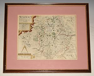
An original antique map of WARWICKSHIRE (Warwici comitatus.) From CAMDEN's Britannia.
Published by 1637, 1637
Seller: PROCTOR / THE ANTIQUE MAP & BOOKSHOP, DORCHESTER, United Kingdom
Association Member: PBFA
Seller Rating:
Approx 21 x 18.5 inches framed. (14.5 x 12 ins within mount.) Hand coloured. Mounted. Framed behind glass in gilded wooden frame. In good condition. Plate a little darkened. Slightly creased lower right corner. Small mark top margin fore edge. Early garish hand-colouring. It features a scrolled title cartouche, mileage scale, map dividers and compass rose.