Order Total (1 Item Items):
Shipping Destination:

Tallis, J H (42 results)
Skip to main search results
Product Type
- All Product Types
- Books (37)
- Magazines & Periodicals (4)
- Comics
- Sheet Music
- Art, Prints & Posters
- Photographs
- Maps (1)
-
Manuscripts &
Paper Collectibles
Condition
Binding
Collectible Attributes
- First Edition (6)
- Signed
- Dust Jacket
- Seller-Supplied Images (17)
- Not Printed On Demand (39)
Free Shipping
Seller Location
Seller Rating
-

THE POLLEN RECORD OF EMPETRUM NIGRUM IN SOUTHERN PENNINE PEATS: IMPLICATIONS FOR EROSION AND CLIMATE CHANGE
Published by J Ecology, 1997
Magazine / Periodical
Pamphlet. Condition: Very Good. Vol 85, pp. 455-465, Illus, 4to, Extracted from orig vol, thus begins with title page, trimmed & stapled pamphlet, else VG.
-
CLIMATE AND EROSION SIGNALS IN BRITISH BLANKET PEATS: THE SIGNIFICANCE OF RACOMITRIUM LANUGINOSUM REMAINS
Published by J Ecology, 1995
Magazine / Periodical
Pamphlet. Condition: Very Good. Vol 83, pp. 1021-1030, Illus, 4to, Extracted from orig vol, thus begins with title page, trimmed & stapled pamphlet, else VG.
-
Forest and Moorland in the South Pennine Uplands in the Mid-Flandrian Period, II. The Hillslope Forests
Published by J Ecology, 1990
Magazine / Periodical
Pamphlet. Condition: Very Good. Vol 78, pp. 857-883, Illus, Extracted from orig vol, begins with title page, trimmed & stapled, thus is like a pamphlet, last page in facsimile (Pamphlet), else VG.
-
POOL-AND-HUMMOCK PATTERNING IN A SOUTHERN PENNINE BLANKET MIRE I. STRATIGRAPHIC PROFILES FOR THE LAST 2800 YEARS; II. THE FORMATION AND EROSION OF THE POOL SYSTEM [2 PAPERS]
Published by J Ecology, 1994
Magazine / Periodical
Pamphlet. Condition: Very Good. Vol 82, pp. 775-803, Illus, Extracted from orig vol, thus begins with title page, trimmed & stapled pamphlet, else VG.
-
Soft cover. Condition: Good. Rapkin, J ; Winkles, H ; Kernot (illustrator). Original 1851 map published by J & F Tallis of London. Gorgeous engravings by J Ripkin, illustratrations by Winkles and Kernot, map drawn and engraved by J. Rapkin. Hand coloured outlines, decorative borders, beautiful engraved vignettes within border edges. This rare map will be exceedingly handsome when properly mounted and framed. Overall dimensions are 14-1/2" x 10-1/2". Bottom edge slightly frayed however this should be addressed once mounted. Cited in Tooley's Dictionary of Maps. Slight age-toning, but still remarkably clean and bright. Bottom right hand corner has been tape repaired. Wonderful vignette illustrations of Potosi, Lima, Swimming Couriers or Peru, Tarija.
-
No Binding. Condition: Good. H. Warren & J. Rogers. (illustrator). 1st Edition. Landscape format map of Turkey In Europe. With 4 vignette steel engravings by Henry Warren. Inset map of Candia and 3 vignettes. Outline coloured. 4 thin old ink drops or lines on the map and one in border, ornate border, would clean off with a solution of water and patience, edges a little aged and top edge thumbed. It also has a two page description of the history and population details, etc. Measures: 36 x 26.5 cm approx. Good to Very good. 1851.
-
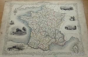
No Binding. Condition: Good. A. H. Wray & J. Rogers. (illustrator). 1st Edition. Landscape format map of France. With 6 engraved vignettes by J. Wray outline coloured, some heavy thumbing marks to borders and light old ink smudges to top right affecting map a little, would erase with a little patient water and brush work. Map is still very good. Sold with a two page description of the country, population, etc. Measures: 36 x 26.5 cm approx. Good to Very good. 1851.
-
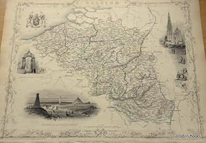
No Binding. Condition: Good. H.Marchant & J. B. Allen. (illustrator). 1st Edition. Landscape format map of Belgium with 3 engraved views and a Royal Crest. A little aged at border and side edges thumbed a little. Measures: 36 x 26.5 cm approx. Good to Very good. 1851.
-
No Binding. Condition: Good. A. H. Wray & J. Rogers. (illustrator). 1st Edition. Landscape format map of Switzerland. With 6 engraved vignettes by J. Wray outline coloured, some heavy thumbing marks to borders and light old ink smudges to top right affecting map a little, would erase with a little patient water and brush work. Map is still very good. Sold with a two page description of the country, population, etc. Measures: 36 x 26.5 cm approx. Good to Very good. 1851.
-
Soft cover. Condition: Fine. Rapkin, J ; Winkles, H (illustrator). Original 1851 map published by J & F Tallis of London. Gorgeous engravings by J Ripkin, illustratrations by Winkles, map drawn and engraved by J. Rapkin. Hand coloured outlines, decorative borders, beautiful engraved vignettes within border edges. This rare map will be exceedingly handsome when properly mounted and framed. Overall dimensions are 14-1/2" x 10-1/2". Bottom edge slightly frayed however this should be addressed once mounted. Cited in Tooley's Dictionary of Maps. Slight age-toning, but still remarkably clean and bright. Wonderful vignette illustrations of Christmas Cataract, Georgetown and Ataraipu Devil's Rock.
-
1851 Map of Venezuela - New Granada - Equador & Ghayanas with Engravings
Published by J & F Tallis, London, 1851
Book
Soft cover. Condition: Fine. Rapkin, J ; Winkles, H ; Lacey, W. (illustrator). Original 1851 map published by J & F Tallis of London. Gorgeous engravings by J Ripkin, illustratrations by Winkles and Lacey, map drawn and engraved by J. Rapkin. Hand coloured outlines, decorative borders, beautiful engraved vignettes within border edges. This rare map will be exceedingly handsome when properly mounted and framed. Overall dimensions are 14-1/2" x 10-1/2". Bottom edge slightly frayed however this should be addressed once mounted. Cited in Tooley's Dictionary of Maps. Slight age-toning, but still remarkably clean and bright. Wonderful vignette illustrations of Fall of the Ragota and other scenes.
-
Soft cover. Condition: Fine. Rapkin, J ; Winkles, H ; Lacey, W. (illustrator). Original 1851 map published by J & F Tallis of London. Gorgeous engravings by J Ripkin, illustratrations by Winkles and Lacey, map drawn and engraved by J. Rapkin. Hand coloured outlines, decorative borders, beautiful engraved vignettes within border edges. This rare map will be exceedingly handsome when properly mounted and framed. Overall dimensions are 14-1/2" x 10-1/2". Bottom edge slightly frayed however this should be addressed once mounted. Cited in Tooley's Dictionary of Maps. Slight age-toning, but still remarkably clean and bright. Wonderful vignette illustrations of Monte Video, Cape St. Antonio Bahia, Rio di Janeiro, Boats on the Rio Negro, St. Catharina.
-
Soft cover. Condition: Fine. Rapkin, J ; Winkles, H ; Lacey, W. (illustrator). Original 1851 map published by J & F Tallis of London. Gorgeous engravings by J Ripkin, illustratrations by Winkles and Lacey, map drawn and engraved by J. Rapkin. Hand coloured outlines, decorative borders, beautiful engraved vignettes within border edges. This rare map will be exceedingly handsome when properly mounted and framed. Overall dimensions are 14-1/2" x 10-1/2". Bottom edge slightly frayed however this should be addressed once mounted. Cited in Tooley's Dictionary of Maps. Slight age-toning, but still remarkably clean and bright. Wonderful vignette illustrations of the travelling post, the "Gobernador", Grand Square of Buenos Ayres, a Water Seller in Buenos Aires.
-
Soft cover. Condition: Fine. Rapkin, J ; Winkles, H ; Radclyffe, E. (illustrator). Original 1851 map published by J & F Tallis of London. Gorgeous engravings by J Ripkin, illustratrations by H Winkles and E. Radcylffe, map drawn and engraved by J. Rapkin. Hand coloured outlines, decorative borders, beautiful engraved vignettes within border edges. This rare map will be exceedingly handsome when properly mounted and framed. Overall dimensions are 14-1/2" x 10-1/2". Bottom edge slightly frayed however this should be addressed once mounted. Cited in Tooley's Dictionary of Maps. Slight age-toning, but still remarkably clean and bright. Map depicts the Western Coast of Africa ( Guinea - Senegambia [Senegal Gambia] and the Sudan) with illustrations of Bakel, Sierra Leone, Cape Coast Castle and Christiansborg.
-
Soft cover. Condition: Fine. Rapkin, J ; Winkles, H ; Lacey, W. (illustrator). Original 1851 map published by J & F Tallis of London. Gorgeous engravings by J Ripkin, illustratrations by H Winkles and W. Lacey, map drawn and engraved by J. Rapkin. Hand coloured outlines, decorative borders, beautiful engraved vignettes within border edges. This rare map will be exceedingly handsome when properly mounted and framed. Overall dimensions are 14-1/2" x 10-1/2". Bottom edge slightly frayed however this should be addressed once mounted. Cited in Tooley's Dictionary of Maps. Slight age-toning, but still remarkably clean and bright. Map depicts the African coastline along the Indian Ocean, states of Kaffraria, Umzimvoombu, Ingali, Umbezan, Umsimkuli, Drakenberg, Maritzburg, Durban, Imyoti, Impafane, Uptukula, Umzinyati, Zulu Country. Lovely illustrations of the entrance to Port Natal and a view of Durban with an encampment in the foreground.
-
Soft cover. Condition: Fine. Rapkin, J ; Warren, H ; Kernot, J H (illustrator). Original 1851 map published by J & F Tallis of London. Gorgeous engravings by J Ripkin, illustratrations by H Warren and J H Kernot, map drawn and engraved by J. Rapkin. Hand coloured outlines, decorative borders, beautiful engraved vignettes within border edges. This rare map will be exceedingly handsome when properly mounted and framed. Overall dimensions are 14-1/2" x 10-1/2". Bottom edge slightly frayed however this should be addressed once mounted. Cited in Tooley's Dictionary of Maps. Slight age-toning, but still remarkably clean and bright. Map depicts the entire Asia Minor with countries then named Anadolia, Itshili, Karamania, Adana, Rum or Sivas, Trebisonde, Diyar-Bekr, Aleppo, Marash, Cyprus, Archipelago, and so on. These countries are now known as Turkey. Wonderful vignette illustrations of Rhodes, Olympus, a ship, and two men.
-
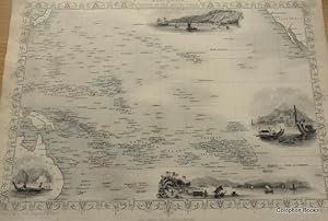
Map of Polynesia Or Islands In the Pacific.
Published by John Tallis & Company., London., 1851
Book First Edition
No Binding. Condition: Good. J. Rapkin, H. Wrinkles & T. Whiteman. (illustrator). 1st Edition. Landscape format map of The Polynesia group of Islands. With 4 vignette steel engravings by T. Whightson. California top right and New Guinea/Australia lower left. Outline colouring, some handling to edges and border, small closed split at left edge, map not affected, map with ornate border still very good. Has the two page leaf of text on climate and population and exports, etc. Measures: 36 x 26.5 cm approx. Good to Very good. (Would frame beautifully). 1851.
-

BLANKET MIRE DEGRADATION Causes, Consequences and Challenges PROCEEDINGS
Published by The Macaulay Land Use Research Institute, Aberdeen, 1997
ISBN 10: 0708405975ISBN 13: 9780708405970
Book First Edition
Soft cover. Condition: Very Good+. First Edition. The proceedings of the Blanket Mire Degradation Conference held at Manchester University in April 1997. Published on behalf of the Mires Research Group. 10 colour photographs plus maps, tables, graphs and diagrams. Large format. PO printed bookplate o/w clean throughout. All our UK orders are sent by First Class post. All profits to Amnesty International.
-
MAP OF PART OF SOUTH AUSTRALIA Centred Round Spencer Gulf
Published by JOHN TALLIS, LONDON, 1850
Seller: K Books Ltd ABA ILAB, York, YORKS, United Kingdom
Association Member: ABA ILAB PBFA
Seller Rating:

Book
No Binding. Condition: Very Good. H WARREN. J ROGERS J RAPKIN (illustrator). Antique map . Hand coloured, engraved map. mounted - matted - and ready to frame .10 x 13 inches. a vg copy of an attractive decorative hand coloured antique map. . A splendid map, colouring not contemporary but delicately and expertly done - a fine map of part of South Australia with colour washed vignettes of Adelaide, the seal of South Australia, a dingo, aborigines on a Catamaran and a bird called a Nymphicus.
-
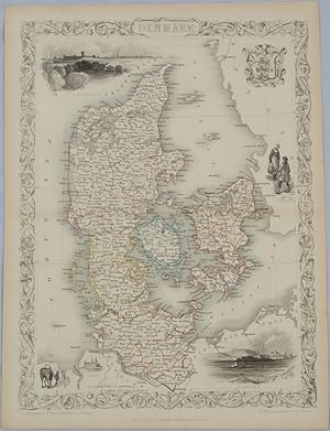
Denmark.
Published by John Tallis & Company. [Circa1850s]., London & New York., 1850
Seller: Asia Bookroom ANZAAB/ILAB, Canberra, ACT, Australia
Association Member: ANZAAB ILAB
Seller Rating:
Lithographed map, with original outline hand colour, 34.5 x 24.7 cm (including border and captions),five fine vignette illustrations, decorative border, central fold, edges with light toning in very good condition. Attractive decorative map with fine vignettes of Copenhagen, Sleswig and Elsinore, figures in costume, the coat of arms of Denmark and an amiable equine pair by the great mapmaker and publisher John Tallis.
-
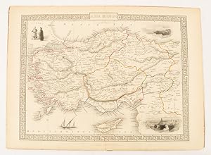
Asia Minor.
Published by Tallis, J & F. [1851]., London & New York., 1851
Seller: Asia Bookroom ANZAAB/ILAB, Canberra, ACT, Australia
Association Member: ANZAAB ILAB
Seller Rating:
Lithographed map 24.5 x 32.3 cm, borders picked out in original hand colour, four inset vignette illustrations, decorative Greek key border, edge worn and discoloured, paper toned, but the attractive map in good condition. Attractive decorative map prepared for "Tallis's illustrated atlas and modern history of the world." one of the last great illustrated series of world maps. The fine vignettes are of Mt. Olympus, Rhodes, a ketch in the Mediterranean Sea and two costumed Ottomans.
-
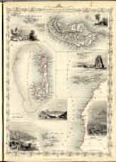
Islands In The Atlantic. The Illustrations Drawn & Engraved by H. Winkles. The Map Drawn & Engraved by J. Rapkin.
Published by John Tallis & Co, London ; New York, 1854
Map
No Binding. Condition: Fine. map : hand col.; 23 x 23 cm.,Ancillary maps: [Azores or Western Isles] -- [Madeira. Scale ca. 1:210,000] -- [Bermudas or Summer Islands. Scale ca. 1:280,000].Includes 6 steel engraved views. Islands shown include the Azores, Madeira, Bermuda, the Canaries and the Cape Verdes. In outline color with drawings of the ports or local sites. Surrounded by a decorative border.
-

Brocklehurst's Textbook of Geriatric Medicine and Gerontology
Published by Elsevier, 1998
ISBN 10: 0443053707ISBN 13: 9780443053702
Book
Condition: New. pp. 1683 5th Edition.
More buying choices from other sellers on AbeBooks
New offers from US$ 146.47
-
MAP OF NEW SOUTH WALES, AUSTRALIA.
Published by JOHN TALLIS, LONDON, 1850
Seller: K Books Ltd ABA ILAB, York, YORKS, United Kingdom
Association Member: ABA ILAB PBFA
Seller Rating:
Book
No Binding. Condition: Very Good. H WARREN. J ROGERS J RAPKIN (illustrator). Antique map . Hand coloured, engraved map. mounted - matted - and ready to frame .10 x 13 inches. a vg copy of an attractive decorative hand coloured antique map. . A splendid map, colouring not contemporary but delicately and expertly done - a fine map of New South Wales, Australia with colour washed vignettes of the Murray River, Sydney Cove and a Xanthorrhaea plant.
-

Plant Community History Long-term Changes in Plant Distribution and Diversity
Published by Chapman and Hall, London, 1991
ISBN 10: 0412303205ISBN 13: 9780412303203
Book
Hardcover. Condition: Very Good with no dust jacket. 398 pages. stamped on leading edge of pages and verso of title page. date stamp on first page with small library sticker, and larger library sticker on inside rear cover. no spine label or number, no pocket. ; Ex College Library; 6 1/4 x 9 1/2 ".
More buying choices from other sellers on AbeBooks
New offers from US$ 242.75
Used offers from US$ 150.00
Also find Hardcover
-

Cape Colony.
Published by (Tallis, John). [1851]., [London]., 1851
Seller: Asia Bookroom ANZAAB/ILAB, Canberra, ACT, Australia
Association Member: ANZAAB ILAB
Seller Rating:
Lithographed map 24.2 x 32 cm, districts picked out in original hand colour, inset vignette illustrations, decorative border, lower margin ragged, but the attractive map in very good condition. Attractive decorative map from "Tallis's illustrated atlas and modern history of the world." one of the last great illustrated series of world maps. The fine vignettes are of Cape Town, Graham Town and entrance to the Knysha Heads.
-
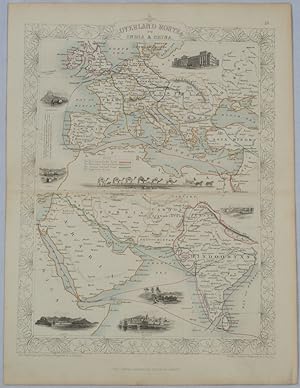
Overland Route to India and China
Published by The London Printing and Publishing Company. [circa1850s]., London., 1850
Seller: Asia Bookroom ANZAAB/ILAB, Canberra, ACT, Australia
Association Member: ANZAAB ILAB
Seller Rating:
Lithographed map, with original outline hand colour, 33 x 24.5 cm (including border and captions), seven vignette illustrations, two reference keys, decorative border, central fold, light toning, mainly at the central fold, and to the verso of the sheet, in very good condition, preserved in a window mount. Attractive decorative map with fine vignettes of the London Post Office, Suez, Bombay, Madras. Aden, Malta, Gibraltar and a wonderful camel train led by a carriage and horses crossing North Africa, originally by the great mapmaker and publisher John Tallis. The two reference keys note steam packet routes, railways, electric telegraph and the Suez Canal. From the estate of the late collector and scholar Arthur Hacker, with his pencilled catalogue mark on the verso.
-

Plant Community History. Long-term changes in plant distribution and diversity.
Published by 1st. Ed. Pub. Chapman & Hall. 1991, 1991
Seller: C. Arden (Bookseller) ABA, Hay-on-Wye, United Kingdom
Seller Rating:
pp.x, 398 with b/w. text figs. 8vo. Neat signature. Fine hardback. In-print at �200.00. This presents a global overview of vegetational changes in response to large-scale environmental changes, particularly climate, in the last 65 million years, and draws on new research in palynology, climatology, geophysics and oceanography.
-
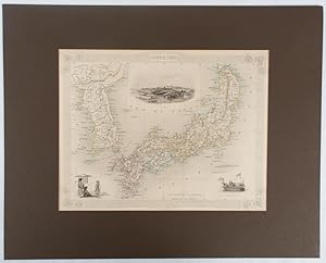
Japan & Corea
Published by The London Printing and Publishing Company. [circa1850s]., London., 1850
Seller: Asia Bookroom ANZAAB/ILAB, Canberra, ACT, Australia
Association Member: ANZAAB ILAB
Seller Rating:
Lithographed map, with original outline hand colour, 25.8 x 33.5 cm, three vignette illustrations, decorative border, central fold, in very good condition, presented in a window mount. Attractive decorative map with three vignettes by Rapkin: Yedo; a State barge in sail with penants flying--the paired oarsmen depicted through 10 small windows below deck; and Koreans in traditional costume; the map after the great mapmaker and publisher John Tallis. From the estate of the late collector and scholar Arthur Hacker, with his pencilled catalogue mark on the verso.