Order Total (1 Item Items):
Shipping Destination:

Tanner, Henry Schenk (4 results)
Skip to main search results
Product Type
- All Product Types
- Books (3)
- Magazines & Periodicals
- Comics
- Sheet Music
- Art, Prints & Posters
- Photographs
- Maps (1)
-
Manuscripts &
Paper Collectibles
Condition
- All Conditions
- New
- Used
Binding
- All Bindings
- Hardcover (2)
- Softcover
Collectible Attributes
- First Edition (1)
- Signed
- Dust Jacket
- Seller-Supplied Images (3)
- Not Printed On Demand
Free Shipping
Seller Location
Seller Rating
-

Map of the States of Maine, New Hampshire, Vermont, Massachusetts, Connecticut and Rhode Island
Published by H.S. Tanner & T.R. Tanner c. 1843, Philadlephia, 1843
Seller: Alexandre Antique Prints, Maps & Books, Toronto, ON, Canada
Seller Rating:

Map
First appearing in his 1823 American Atlas, this map by H.S. Tanner shows a detailed look of the New England States, with state capitals, county towns, villages, canals and railroads. Includes a decorative cartouche of a rocky mountain terrain along an ocean setting. H.S. Tanner is one of the most important cartographers in American History. As a publisher, he produced seminal works such as Mills Atlas of South Carolina. Perhaps his most important work is his American Atlas, which represented a breakthrough in quality, both in engraving and production, as well as the first elephant folio format atlas utilizing indigenous cartography to be published in the U.S. The atlas was published by Tanner and his son Thomas R. Tanner, for over 20 years., Size : 679x552 (mm), 26.75x21.75 (Inches), Original Hand Coloring Some surface abrasion on the upper part of the map restored otherwise good. Laid down on acid free tissue paper for long term preservation.
-
The American Traveller; or Guide Through the United States. Containing Brief Notices of the Several States, Cities, Principal Towns, Canals and Rail Roads, &c. With Tables of Distances, by Stage, Canal and Steam Boat Routes.
Published by The Author, Philadelphia, 1839
Seller: The Odd Book (ABAC, ILAB), Wolfville, NS, Canada
Seller Rating:

Book
Cloth. Condition: Very Good. Fourth edition. 144 pages, four plates, four 2-page maps and the large hand tinted map at rear. Spine sunned; foxing to endpapers and less-so throughout [maps and plates clean]. Signature between pages 16 and 21 detached. Large folding map excellent.
-
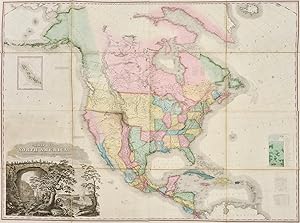
A Map of North America, Constructed To The Latest Information
Published by Henry, Philadelphia, 1825
Seller: Argosy Book Store, ABAA, ILAB, New York, NY, U.S.A.
Seller Rating:
unbound. Condition: very good. Map. Engraving with hand coloring. Measures 44.25 x 59 inches. In very good condition. Tanner's large scale map of North America is one of the most significant maps of the continent of the 19th century. It combines the information garnered from a host of important expeditions, such as Lewis and Clark, Pike, and James, into a single map that shows the extent of North America in 1825. Some of the most notable portions of the map include the Mississippi and Missouri River Valleys, the Columbia River Basin, the Rocky Mountains, Texas, and the Oregon Territory. Copious informational notes throughout give further insight into the knowledge held of this region at the time of the map's publication. In addition to its cartographic achievement, the map also boasts a magnificent title cartouche that combines the North American landmarks of Niagara Falls and Natural Bridge with wildlife native to different parts of the region, such as a rattlesnake, eagle, beaver, moose, and a polar bear.
-
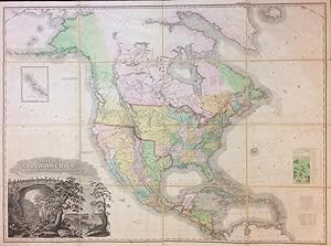
A New American Atlas containing maps of the several states of the North American union Projected and Drawn on a Uniform Scale
Published by Philadelphia: H. S. Tanner, 1823, 1823
Seller: 19th Century Rare Book & Photograph Shop, Stevenson, MD, U.S.A.
Seller Rating:
First Edition
Hardcover. Condition: Fine. 1st Edition. First edition of the most distinguished atlas published in the United States during the engraving period (Ristow). Tanner s greatest work, A New American Atlas was painstakingly produced and issued in installments between 1818 and 1823. Few complete sets have survived. Tanner s use of a uniform scale of 15 geographical miles to the inch and his careful selection of sources resulted in a comprehensive American atlas of unprecedented detail and reliability which was the standard by which American atlases were measured until the modern era. This was by a considerable margin the greatest American atlas up to its time. The spectacular folding map of North America is a high point of American cartography. The map was a landmark a great cartographic achievement [and] was the progenitor of a long line of famous maps (Wheat). This tremendous map, measuring 58 x 45 inches, reflects the extent of the Lewis and Clark discoveries and presents findings of the expeditions of Pike, James, and the other great early overland surveys. Tanner was endowed with that combination of scientific and artistic sense that spells the true cartographer and that led him ultimately to produce for his time the outstanding map representations of the territory of the United States. No modern atlas of relatively equal merit is available to the American public today (Dictionary of American Biography). Phillips 1374. Wheat, Mapping the Transmississippi West 350. Large folio. Complete with engraved title with historical vignette, 18 large double page or folding maps (constructed from 22 sheets). A minor tear, a few very slight abrasions, occasional minor dust soiling. Fine contemporary tree calf gilt, boards with elaborate gilt tooling at edges, joints repaired. Maps in fine bright condition, original hand coloring throughout. A wonderful copy.