
Order Total (1 Item Items):
Shipping Destination:

Thornton, John 1641 1708 & Samuel Fl 1703 39 (4 results)
Skip to main search results
Product Type
- All Product Types
- Books
- Magazines & Periodicals
- Comics
- Sheet Music
- Art, Prints & Posters
- Photographs
- Maps (4)
-
Manuscripts &
Paper Collectibles
Condition
- All Conditions
- New
- Used
Binding
- All Bindings
- Hardcover
- Softcover
Collectible Attributes
- First Edition
- Signed
- Dust Jacket
- Seller-Supplied Images
- Not Printed On Demand
Seller Location
Seller Rating
-
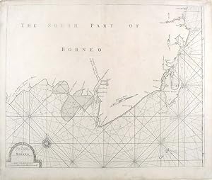
A Large Draught of the South Part of Borneo
Published by William Mount & Thomas Page, London, 1734
Seller: Donald A. Heald Rare Books (ABAA), New York, NY, U.S.A.
Seller Rating:

Map
Copper-engraved sea chart, in excellent condition apart from a skillfully repaired marginal split at the base of the centerfold and marginal soiling. A very attractive sea chart of southern Borneo, from the celebrated Third Book of the 'English Pilot' This very attractive sea chart depicts Kalimantan, now the Indonesian section of Borneo and the adjacent part of the Java Sea. While the delineation of the coast is geographically well assured, the interior of the island is shown to be virtually unknown. Inhabited by fierce indigenous tribes and exotic animals, agents of the Dutch East Indian Company, who then nominally controlled the coasts, were afraid to venture into the interior. Indeed, parts of Borneo have not even been fully explored to this day. The Java Sea is elegantly adorned with rhumb lines that radiate from a compass rose and from centerpoints placed on an invisible circle. A handsome title cartouche embellishes the lower left corner of the composition. In 1671, the London cartographer John Seller (fl.1664-97) commenced work on The English Pilot, a work that intended to challenge Dutch hegemony in the sea atlas market. Intended to be published in four books covering different regions of the globe, Seller published an uncompleted book on 'Oriental navigation' in 1675. Unable to continue this Herculean endeavour, Seller sold his rights to John Thornton, the official hydrographer to the English East India Company. Thornton took up the project with great fervour, publishing his first editions in 1689. Thornton did not publish his first edition of the Third Book, detailing navigation in the East Indies, until 1703. While Thornton largely based his charts on those of earlier Dutch cartographers, most notably those found in Pieter Goos' Zee-Spiegel and Lucas Janz Waghenaer's Mariner's Mirror, The English Pilot proved to be enormously popular. When John Thornton died in 1708, his brother Samuel took over the business and added to and modified existing charts. All four books were produced in editions until the 1760s, the Third Book ran into twelve editions up to 1761. The project succeeded in giving the English dominance in the sea chart market as the eighteenth-century progressed. National Maritime Museum (Greenwich), chart G258:2/17; Cf. Phillips, Atlases, 4278-38; Verner & Skelton (eds.), John Thornton - The English Pilot: The Third Book (Facsimile 1703 edition).
-
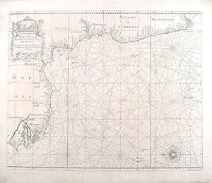
A Chart of the Coast of Guinea from Cape de Verde to Cape Bona Esperan�a
Published by William Mount & Thomas Page, London, 1734
Seller: Donald A. Heald Rare Books (ABAA), New York, NY, U.S.A.
Seller Rating:
Map
Copper-engraved sea chart, in excellent condition. A very elegant sea chart of all of the west coast of Africa and one of the most important charts of the celebrated Third Book of 'The English Pilot' This very fine sea chart embraces the coast of Africa from Senegal all the way down to Cape Agulhas, past the Cape of Good Hope. The features of the coast are named in great detail, and the seas are elegantly traversed by loxodromes. The map is oriented with the east towards the top of the map, and a very beautiful cartouche surrounded by mermen and seashells adorns the upper left corner. In 1671, the London cartographer John Seller (fl.1664-97) commenced work on The English Pilot, a work that intended to challenge Dutch hegemony in the sea atlas market. Intended to be published in four books covering different regions of the globe, Seller published an uncompleted book on 'Oriental navigation' in 1675. Unable to continue this Herculean endeavour, Seller sold his rights to John Thornton, the official hydrographer to the English East India Company. Thornton took up the project with great fervour, publishing his first editions in 1689. Thornton did not publish his first edition of the Third Book, detailing navigation in the East Indies, until 1703. While Thornton largely based his charts on those of earlier Dutch cartographers, most notably those found in Pieter Goos' Zee-Spiegel and Lucas Janz Waghenaer's Mariner's Mirror, The English Pilot proved to be enormously popular. When John Thornton died in 1708, his brother Samuel took over the business and added to and modified existing charts. All four books were produced in editions until the 1760s, the Third Book ran into twelve editions up to 1761. The project succeeded in giving the English dominance in the sea chart market as the eighteenth-century progressed. Cf. Phillips, Atlases, 4278-10; Verner & Skelton (eds.), John Thornton - The English Pilot: The Third Book (Facsimile 1703 edition).
-

A Large Draught of the Coast of Arabia from Maculla to Dofar
Published by William Mount & Thomas Page, London, 1734
Seller: Donald A. Heald Rare Books (ABAA), New York, NY, U.S.A.
Seller Rating:
Map
Copper-engraved sea chart by Sutton Nichols, in excellent condition apart from a small expert repair to the lower right and left corners. A very fine sea chart of the coast of Yemen and Oman from the celebrated Third Book of 'The English Pilot' This very attractive sea chart depicts the coast of the Arabian Peninsula from Al Makullah in Yemen to Dhofar in Oman. The coastal view is bisected into two images, separated by a border formed by the elegant tendrils of a vine. The upper view depicts the southern, while the lower portrays the northern aspect of the coast. Prominent features of the desert coastline are depicted, while compass roses, from which radiate rhumb lines, decorate the seas. In 1671, the London cartographer John Seller (fl.1664-97) commenced work on The English Pilot, a work that intended to challenge Dutch hegemony in the sea atlas market. Intended to be published in four books covering different regions of the globe, Seller published an uncompleted book on 'Oriental navigation' in 1675. Unable to continue this Herculean endeavour, Seller sold his rights to John Thornton, the official hydrographer to the English East India Company. Thornton took up the project with great fervour, publishing his first editions in 1689. Thornton did not publish his first edition of the Third Book, detailing navigation in the East Indies, until 1703. While Thornton largely based his charts on those of earlier Dutch cartographers, most notably those found in Pieter Goos' Zee-Spiegel and Lucas Janz Waghenaer's Mariner's Mirror, The English Pilot proved to be enormously popular. When John Thornton died in 1708, his brother Samuel took over the business and added to and modified existing charts. All four books were produced in editions until the 1760s, the Third Book ran into twelve editions up to 1761. The project succeeded in giving the English dominance in the sea chart market as the eighteenth-century progressed. Tibbetts, Arabia in Early Maps, 177; Cf. Phillips, Atlases, 4278-18; Verner & Skelton (eds.), John Thornton - The English Pilot: The Third Book (Facsimile 1703 edition).
-
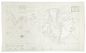
A Large Draught of the North Part of China Shewing the Passages and the Chanells into the Harbour of Chusan
Published by William Mount & Thomas Page, London, 1734
Seller: Donald A. Heald Rare Books (ABAA), New York, NY, U.S.A.
Seller Rating:
Map
Copper-engraved sea chart, in excellent condition, apart from an expertly repaired centre fold, and mild creases where the map folded. A very fine sea chart of China's Zhejiang Province, from the celebrated Third Book of 'The English Pilot.' This elegant and large sea chart captures China's modern day Zhejiang province. Located on the East China sea, just below the Yangtze Delta, this region was of major interest to European traders during the eighteenth-century. It features the major port of Zhousan (Chusan), and was the location of the entrance of the Grand Canal of China. The canal, construction of which began in the 5th-century B.C., was then the oldest and longest man-made waterway in the world, which allowed barges to travel hundreds to Beijing. In 1671, the London cartographer John Seller (fl.1664-97) commenced work on The English Pilot, a work that intended to challenge Dutch hegemony in the sea atlas market. Intended to be published in four books covering different regions of the globe, Seller published an uncompleted book on 'Oriental navigation' in 1675. Unable to continue this Herculean endeavour, Seller sold his rights to John Thornton, the official hydrographer to the English East India Company. Thornton took up the project with great fervour, publishing his first editions in 1689. Thornton did not publish his first edition of the Third Book, detailing navigation in the East Indies, until 1703. While Thornton largely based his charts on those of earlier Dutch cartographers, most notably those found in Pieter Goos' Zee-Spiegel and Lucas Janz Waghenaer's Mariner's Mirror, The English Pilot proved to be enormously popular. When John Thornton died in 1708, his brother Samuel took over the business and added to and modified existing charts. All four books were produced in editions until the 1760s, the Third Book ran into twelve editions up to 1761. The project succeeded in giving the English dominance in the sea chart market as the eighteenth-century progressed. Cf. Phillips, Atlases, 4278-36; Verner & Skelton (eds.), John Thornton - The English Pilot: The Third Book (Facsimile 1703 edition).