
Order Total (1 Item Items):
Shipping Destination:

U S Coast Survey Office (730 results)
Skip to main search results
Product Type
- All Product Types
- Books (729)
- Magazines & Periodicals
- Comics
- Sheet Music
- Art, Prints & Posters (1)
- Photographs
- Maps
-
Manuscripts &
Paper Collectibles
Condition
Binding
- All Bindings
- Hardcover (5)
- Softcover
Collectible Attributes
- First Edition (1)
- Signed
- Dust Jacket
- Seller-Supplied Images (728)
- Not Printed On Demand (728)
Free Shipping
Seller Location
Seller Rating
-
![Seller image for The King plats of the city of Washington in the District of Columbia, 1803 [LeatherBound] for sale by True World of Books](https://pictures.abebooks.com/inventory/md/md31533876537.jpg)
The King plats of the city of Washington in the District of Columbia, 1803 [LeatherBound]
Publication Date: 2023
Book Print on Demand
LeatherBound. Condition: New. Leather Binding on Spine and Corners with Golden leaf printing on spine. Bound in genuine leather with Satin ribbon page markers and Spine with raised gilt bands. A perfect gift for your loved ones. Reprinted from 1888 edition. NO changes have been made to the original text. This is NOT a retyped or an ocr'd reprint. Illustrations, Index, if any, are included in black and white. Each page is checked manually before printing. As this print on demand book is reprinted from a very old book, there could be some missing or flawed pages, but we always try to make the book as complete as possible. Fold-outs, if any, are not part of the book. If the original book was published in multiple volumes then this reprint is of only one volume, not the whole set and contains approximately 11 pages. IF YOU WISH TO ORDER PARTICULAR VOLUME OR ALL THE VOLUMES YOU CAN CONTACT US. Resized as per current standards. Sewing binding for longer life, where the book block is actually sewn (smythe sewn/section sewn) with thread before binding which results in a more durable type of binding. Language: English.
-
![Seller image for Required oceanographic instrument suit for oceanographic survey vessels (1961) [LeatherBound] for sale by True World of Books](https://pictures.abebooks.com/inventory/md/md31657427201.jpg)
Required oceanographic instrument suit for oceanographic survey vessels (1961) [LeatherBound]
Publication Date: 2023
Book Print on Demand
LeatherBound. Condition: New. LeatherBound edition. Condition: New. Reprinted from 1961 edition. Leather Binding on Spine and Corners with Golden leaf printing on spine. Bound in genuine leather with Satin ribbon page markers and Spine with raised gilt bands. A perfect gift for your loved ones. NO changes have been made to the original text. This is NOT a retyped or an ocr'd reprint. Illustrations, Index, if any, are included in black and white. Each page is checked manually before printing. As this print on demand book is reprinted from a very old book, there could be some missing or flawed pages, but we always try to make the book as complete as possible. Fold-outs, if any, are not part of the book. If the original book was published in multiple volumes then this reprint is of only one volume, not the whole set. Sewing binding for longer life, where the book block is actually sewn (smythe sewn/section sewn) with thread before binding which results in a more durable type of binding. Pages: 132 Government-Industry Oceanographic Instrumentation Symposium (1961 : Washington, D.C.),United States. Bureau of Commercial Fisheries,United States. Hydrographic Office,U.S. Coast and Geodetic Survey.
-

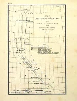
This black and white coastal survey was made by the U.S. Coast Survey Office in 1855. The approximate cotidal lines and the pacific coast line are illustrated on this map. The names of important cities, harbors and rivers are identified. These antique surveys show a fascinating and unique perspective of the areas illustrated. Some margins are close due to the manner in which the surveys were bound. This map measures 7.75 inches by 5 inches.
-
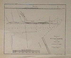
This black and white, antique coastal survey was made for the United States Coast Survey. The surveys provide notes on important characteristics of the area mapped. These charts illustrate areas that have likely undergone significant changes due to modifications and recessions of coastal lands, making them fascinating to anyone interested in local geography and history. This coastal survey, produced in 1853, shows the entrance to Buffalo Harbor, New York. This map measures 5 inches by 6.5 inches.
-
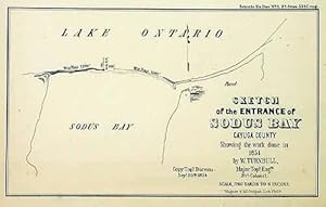
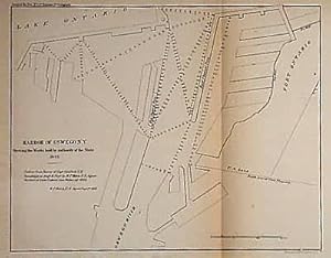
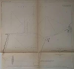
This black and white, antique coastal survey was made for the United States Coast Survey. The surveys provide notes on important characteristics of the area mapped. These charts illustrate areas that have likely undergone significant changes due to modifications and recessions of coastal lands, making them fascinating to anyone interested in local geography and history. This coastal survey, produced in 1855, shows the Harbor of Oswego. This map measures 8.5 inches by 12 inches.
-

Hawaiian Archipelago. [map]
Published by United States: Dept. of Commerce, ca. 1950., 1950
Art / Print / Poster
Condition: Good. Full color lithograph, 29 x 44 cm. in the plate. Mercator Projection, 1: 1,650,000 scale, at Lat. 24 deg. Laminated. Very good.
-
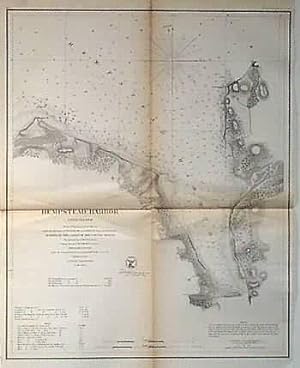
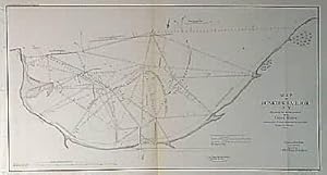
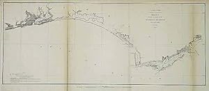
This black and white, antique coastal survey was made for the United States Coast Survey. The surveys provide depth readings and notes on important coastal characteristics of the area mapped. The names of harbors, rivers, islands, channels, shoals, capes, inlets, and coastal towns are identified on the map. These charts show areas that have likely undergone significant changes due to modifications and recessions of coastal lands, making them fascinating to anyone interested in local geography and history. Sold folded as issued. This map measures 11 inches by 15.5 inches.
-
This black and white, antique coastal survey was made for the United States Coast Survey. The surveys provide depth readings and notes on important coastal characteristics of the area mapped. The names of harbors, rivers, islands, channels, shoals, capes, inlets, and coastal towns are identified on the map. These charts show areas that have likely undergone significant changes due to modifications and recessions of coastal lands, making them fascinating to anyone interested in local geography and history. Sold folded as issued. This map measures 5.25 inches by 9 inches.
-
This black and white, antique coastal survey was made for the United States Coast Survey. The surveys provide notes on important coastal characteristics of the area mapped. The names of harbors, rivers, depth readings, and important coastal towns are identified on the map. These charts show areas that have likely undergone significant changes due to modifications and recessions of coastal lands, making them fascinating to anyone interested in local geography and history. This map measures 9 inches by 11.5 inches.
-
This black and white, antique coastal survey was made for the United States Coast Survey. The surveys provide depth readings and notes on important coastal characteristics of the area mapped. The names of harbors, rivers, islands, channels, shoals, capes, inlets, and coastal towns are identified on the map. These charts show areas that have likely undergone significant changes due to modifications and recessions of coastal lands, making them fascinating to anyone interested in local geography and history. Note: Age toning around the folds in these maps is quite common. Map is sold folded as issued. This map measures 7 inches by 14 inches.
-
This black and white, antique coastal survey was made for the United States Coast Survey. The surveys provide notes on important coastal characteristics of the area mapped. The names of harbors, rivers, depth readings, and important coastal towns are identified on the map. These charts show areas that have likely undergone significant changes due to modifications and recessions of coastal lands, making them fascinating to anyone interested in local geography and history. This map measures 10.75 inches by 17.5 inches.
-
This black and white, antique coastal survey was made for the United States Coast Survey. The surveys provide depth readings and notes on important coastal characteristics of the area mapped. The names of harbors, rivers, islands, channels, shoals, capes, inlets, and coastal towns are identified on the map. These charts show areas that have likely undergone significant changes due to modifications and recessions of coastal lands, making them fascinating to anyone interested in local geography and history. Sold folded as issued. This map measures 9.5 inches by 11.5 inches.
-
This black and white, antique coastal survey was made for the United States Coast Survey. The surveys provide notes on important characteristics of the area mapped including depth readings. These charts illustrate areas that have likely undergone significant changes due to modifications and recessions of coastal lands, making them fascinating to anyone interested in local geography and history. This coastal survey, produced in 1855, shows the work erected in Dunkirk Harbor by the United States and the plan of those projected for its further improvement. This map measures 8.75 inches by 16.5 inches.
-

This black and white, antique coastal survey was made for the United States Coast Survey. The surveys provide notes on important characteristics of the area mapped including depth readings. These charts illustrate areas that have likely undergone significant changes due to modifications and recessions of coastal lands, making them fascinating to anyone interested in local geography and history. This coastal survey, produced in 1854, is a chart of the piers at the mouth of the Genesee River, NY. This map measures 6.5 inches by 12 inches.
-
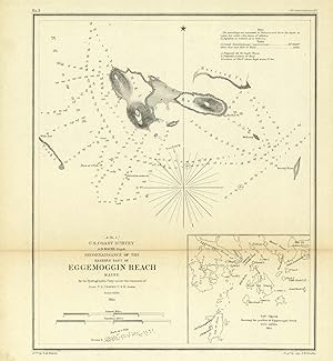
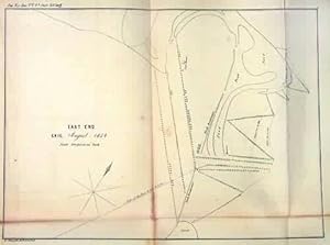
U.S. Coast Survey Reconnaissance of the Eastern Part of Eggemoggin Reach Maine
Publication Date: 1854
This black and white, antique coastal survey was made for the United States Coast Survey. The surveys provide depth readings and notes on important coastal characteristics of the area mapped. The names of harbors, rivers, islands, channels, shoals, capes, inlets, and coastal towns are identified on the map. These charts show areas that have likely undergone significant changes due to modifications and recessions of coastal lands, making them fascinating to anyone interested in local geography and history. Sold folded as issued. This map measures 10.5 inches by 9 inches.
-
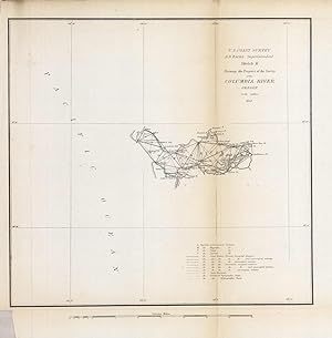
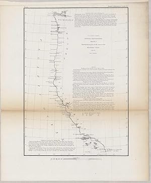
U.S. Coast Survey Sketch K Showing the Progress of the Survey of the Columbia River
Publication Date: 1852
This black and white, antique coastal survey was made for the United States Coast Survey. The surveys provide depth readings and notes on important coastal characteristics of the area mapped. The names of harbors, rivers, islands, channels, shoals, capes, inlets, and coastal towns are identified on the map. These charts show areas that have likely undergone significant changes due to modifications and recessions of coastal lands, making them fascinating to anyone interested in local geography and history. Sold folded as issued. This map measures 7.5 inches by 10 inches.
-
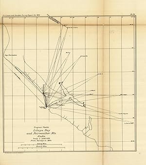
This black and white, antique coastal survey was made for the United States Coast Survey. The surveys provide depth readings and notes on important coastal characteristics of the area mapped. The names of harbors, rivers, islands, channels, shoals, capes, inlets, and coastal towns are identified on the map. These charts show areas that have likely undergone significant changes due to modifications and recessions of coastal lands, making them fascinating to anyone interested in local geography and history. Sold folded as issued. This map measures 26 inches by 17 inches.
-
U.S. Coast Survey Sketch G Showing the Progress of the Survey in Section VII (Panhandle)
Publication Date: 1853
This black and white, antique coastal survey was made for the United States Coast Survey. The surveys provide depth readings and notes on important coastal characteristics of the area mapped. The names of harbors, rivers, islands, light houses, channels, shoals, capes, inlets, and coastal towns are identified on the map. These charts show areas that have likely undergone significant changes due to modifications and recessions of coastal lands, making them fascinating to anyone interested in local geography and history. Note: Age toning around the folds in these maps is quite common. Map is sold folded as issued. This map measures 9.5 inches by 23 inches.
-
This black and white, antique coastal survey was made for the United States Coast Survey. The surveys provide depth readings and notes on important coastal characteristics of the area mapped. The names of harbors, rivers, islands, channels, shoals, capes, inlets, and coastal towns are identified on the map. These charts show areas that have likely undergone significant changes due to modifications and recessions of coastal lands, making them fascinating to anyone interested in local geography and history. Sold folded as issued. This map measures 7.5 inches by 5 inches.
-
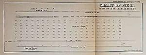
This black and white, antique coastal survey was made for the United States Coast Survey. The surveys provide notes on important characteristics of the area mapped including depth readings. These charts illustrate areas that have likely undergone significant changes due to modifications and recessions of coastal lands, making them fascinating to anyone interested in local geography and history. This coastal survey, produced in 1854, is a chart of the piers at the mouth of the Genesee River, NY. This map measures 4.5 inches by 12 inches.
-
This black and white, antique coastal survey was made for the United States Coast Survey. The surveys provide depth readings and notes on important coastal characteristics of the area mapped. The names of harbors, rivers, islands, light houses, channels, shoals, capes, inlets, and coastal towns are identified on the map. These charts show areas that have likely undergone significant changes due to modifications and recessions of coastal lands, making them fascinating to anyone interested in local geography and history. Note: Age toning around the folds in these maps is quite common. Map is sold folded as issued. This map measures 13.5 inches by 11.5 inches.
-
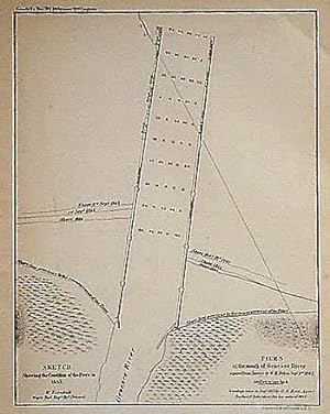
This black and white, antique coastal survey was made for the United States Coast Survey. The surveys provide notes on important characteristics of the area mapped including depth readings. These charts illustrate areas that have likely undergone significant changes due to modifications and recessions of coastal lands, making them fascinating to anyone interested in local geography and history. This coastal survey, produced in 1853, shows the piers at the mouth of the Genesee River. This map measures 8.5 inches by 6.5 inches.
-
This black and white, antique coastal survey was made for the United States Coast Survey. The surveys provide notes on important characteristics of the area mapped including depth readings. These charts illustrate areas that have likely undergone significant changes due to modifications and recessions of coastal lands, making them fascinating collectibles to anyone interested in local geography and history. This coastal survey, produced in 1853, shows the west pier of Oswego Harbor, New York. This map measures 4.5 inches by 15.5 inches.
-
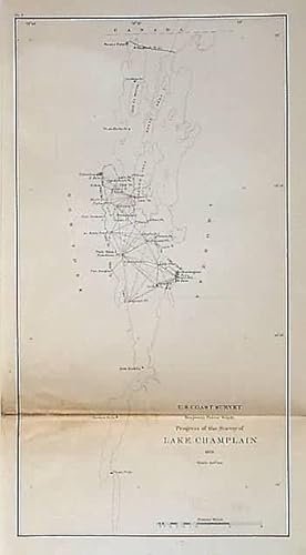
This black and white, antique coastal survey was made for the United States Coast Survey. The surveys provide notes on important characteristics and triangulation between points of the area mapped. The names of harbors, rivers, and important coastal towns are identified on the map. These charts illustrate areas that have likely undergone significant changes due to modifications and recessions of coastal lands, making them fascinating to anyone interested in local geography and history. This coastal survey, produced in 1870, shows the progress of the survey of Lake Champlain. This map measures 12.5 inches by 6.5.
-
U.S. Coast Survey Sketch J Showing the Progress of the Survey of the Western Coast
Publication Date: 1855
This black and white, antique coastal survey was made for the United States Coast Survey. The surveys provide depth readings and notes on important coastal characteristics of the area mapped. The names of harbors, rivers, islands, channels, shoals, capes, inlets, and coastal towns are identified on the map. These charts show areas that have likely undergone significant changes due to modifications and recessions of coastal lands, making them fascinating to anyone interested in local geography and history. Sold folded as issued. This map measures 10.5 inches by 7.5 inches.
-
This black and white, antique coastal survey was made for the United States Coast Survey. The surveys provide notes on important characteristics of the area mapped including depth readings. These charts illustrate areas that have likely undergone significant changes due to modifications and recessions of coastal lands, making them fascinating to anyone interested in local geography and history. This coastal survey, produced in 1854, is a chart of the piers at the mouth of the Genesee River, NY. This map measures 6 inches by 9.5 inches.
-
This black and white, antique coastal survey was made for the United States Coast Survey. The surveys provide depth readings and notes on important coastal characteristics of the area mapped. The names of harbors, rivers, islands, channels, shoals, capes, inlets, and coastal towns are identified on the map. These charts show areas that have likely undergone significant changes due to modifications and recessions of coastal lands, making them fascinating to anyone interested in local geography and history. Sold folded as issued. This map measures 27.5 inches by 9 inches.
-

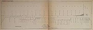
This black and white, antique coastal survey was made for the United States Coast Survey. The surveys provide notes on important characteristics of the area mapped including depth readings. The names of harbors, rivers, and important coastal towns are identified on the map as well. These charts illustrate areas that have likely undergone significant changes due to modifications and recessions of coastal lands, making them fascinating to anyone interested in local geography and history. This coastal survey, produced in 1862, shows the Hudson River from Poughkeepsie to Glasco, New York. This map measures 39 inches by 12.5 inches.
-

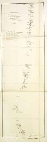
Primary Triangulation Between Long Island and the Blue Ridge Sections II & III
Publication Date: 1871
This black and white, antique coastal survey was made for the United States Coast Survey. The surveys provide depth readings and notes on important coastal characteristics of the area mapped. The names of harbors, rivers, islands, channels, shoals, capes, inlets, and coastal towns are identified on the map. These charts show areas that have likely undergone significant changes due to modifications and recessions of coastal lands, making them fascinating to anyone interested in local geography and history. Sold folded as issued. This map measures 17 inches by 29.5 inches.
-

U.S. Coast Survey Sketch A Showing the Progress of the Survey in Section No. 1
Publication Date: 1877
This black and white, antique coastal survey was made for the United States Coast Survey. The surveys provide notes on important coastal characteristics of the area mapped. The names of harbors, rivers, depth readings, and important coastal towns are identified on the map. These charts show areas that have likely undergone significant changes due to modifications and recessions of coastal lands, making them fascinating to anyone interested in local geography and history. This map measures 18 inches by 28 inches.
