Order Total (1 Item Items):
Shipping Destination:

Engraved Hall (31 results)
Skip to main search results
Search filters
Product Type
- All Product Types
- Books (10)
- Magazines & Periodicals (No further results match this refinement)
- Comics (No further results match this refinement)
- Sheet Music (No further results match this refinement)
- Art, Prints & Posters (14)
- Photographs (No further results match this refinement)
- Maps (6)
- Manuscripts & Paper Collectibles (1)
Condition Learn more
- New (No further results match this refinement)
- As New, Fine or Near Fine (1)
- Very Good or Good (16)
- Fair or Poor (No further results match this refinement)
- As Described (14)
Binding
- All Bindings
- Hardcover (8)
- Softcover (No further results match this refinement)
Collectible Attributes
- First Edition (6)
- Signed (1)
- Dust Jacket (No further results match this refinement)
- Seller-Supplied Images (26)
- Not Print on Demand (31)
Language (3)
Free Shipping
- Free Shipping to U.S.A. (No further results match this refinement)
Seller Location
Seller Rating
-

Condition: Good+. Engraved map, circa 1850s (approx 10 1/2 x 8 inches including margins), with original colour in outline. Small split along the centre fold.
-

Condition: Very Good. Engraved map, circa 1850s (approx 10 1/2 x 8 inches including margins), with original colour in outline. Light tan along the centre fold.
-

Condition: Very Good. Engraved map, circa 1850s (approx 8 x 10 1/2 inches including margins), with original colour in outline. Light tan along the centre fold.
-

Condition: Good+. Engraved map, circa 1850s (approx 10 1/2 x 8 inches including margins), with original colour in outline. Small split along the centre fold.
-

MEMOIR OF MARY L. WARE, WIFE OF HENRY WARE, JR.
Published by Crosby, Nichols, and Co., Boston and New York, 1854
Seller: Riverow Bookshop, Owego, NY, U.S.A.
Seller rating 5 out of 5 stars

Frontis Engraved Portrait (illustrator). 7th thousand. Boston and New York: Crosby, Nichols, and Co. Good condition: cover & text heavily foxed, frayed with stains/No Dustjacket. 1854. 7th thousand. 12mo., vii, 434pp. . Good condition: cover & text heavily foxed, frayed with stains/No Dustjacket.
-
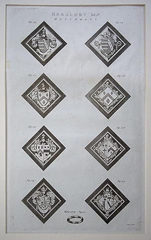
Heraldry, Tab IV. 8 examples of heraldic terms. Hatchments and a Wreath
Publication Date: 1789
Art / Print / Poster
Single sheet. Genuine antique original large copper engraving, printed on hand made laid paper. In very good condition. Shown close up in a free ivory bevelled mount. Standard postage if sent rolled without mount or plus �2 packed flat with mount as then a Medium Parcel. Discount for more than one! 26.5 x 41.5 cm.
-

Pneumatics, Tab V. Wind-mills, a Wind gun and Whispering Place.
Publication Date: 1789
Art / Print / Poster
Single sheet. Genuine antique original large copper engraving, printed on hand made laid paper. In very good condition. Shown close up in a free ivory bevelled mount. Standard postage if sent rolled without mount or plus �2 packed flat with mount as then a Medium Parcel. Discount for more than one! 26.5 x 41.5 cm.
-
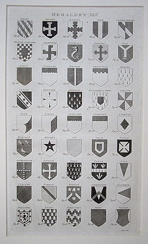
Heraldry, Tab II. 45 examples of heraldic terms - Tinctures, Variations, Divisions, Ordinaries and Charges.
Publication Date: 1789
Art / Print / Poster
Single sheet. Genuine antique original large copper engraving, printed on hand made laid paper. In very good condition. Shown close up in a free ivory bevelled mount. Standard postage if sent rolled without mount or plus �2 packed flat with mount as then a Medium Parcel. Discount for more than one! 26.5 x 41.5 cm.
-
The Favorite Scholar (and Other tales)
Language: English
Published by C. S. Francis & CO., New York, 1844
First Edition
US$ 74.97 25% offUS$ 56.23
US$ 5.38 shipping
Ships within U.S.A.Quantity: 1 available
Add to basketHardcover. Condition: Good Minus. Engraved Frontspiece (illustrator). First Edition. This is a rare book by Mary Howitt from the early 1800's. It is a tan blind-stamped hardcover with gilt lettering and decorations on the spine. the book is lightly faded, it has a few stains on the covers, the inside has mild foxing due to the age of the paper. The hinges are weak, however the book is tight. Email us for a picture, we ship fast. Size: Small.
-
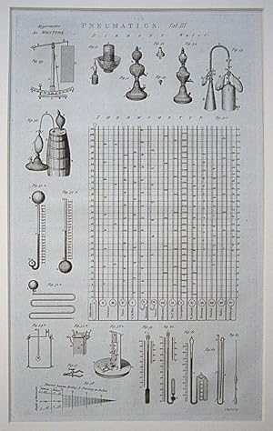
Pneumatics, Tab III. Hygrometer, Barometers, Thermometers, 13 competing temperature scales & Pyrmont (Soda) water manufacture.
Publication Date: 1789
Art / Print / Poster
Single sheet. Genuine antique original large copper engraving, printed on hand made laid paper. In very good condition. Shown close up in a free ivory bevelled mount. Standard postage if sent rolled without mount or plus �2 packed flat with mount as then a Medium Parcel. Discount for more than one! 26.5 x 41.5 cm.
-

Microscopical Objects, Class I. Animal Subjects, inc. Flea, Louse, Mite, Itch, Dog Tick & in Semine Masculino.
Publication Date: 1789
Art / Print / Poster
Single sheet. Genuine antique original large copper engraving, printed on hand made laid paper. In very good condition. Shown close up in a free ivory bevelled mount. Standard postage if sent rolled without mount or plus �2 packed flat with mount as then a Medium Parcel. Discount for more than one! 26.5 x 41.5 cm.
-

Entomology - Insects. 13 species, many shown in multiple engravings, inc. Lantern fly, Locust, Scorpion, Crickets, Papilio, Mantis & Dragonfly.
Publication Date: 1789
Art / Print / Poster
Single sheet. Genuine antique original large copper engraving, printed on hand made laid paper. In very good condition. Shown close up in a free ivory bevelled mount. Standard postage if sent rolled without mount or plus �2 packed flat with mount as then a Medium Parcel. Discount for more than one! 26.5 x 41.5 cm.
-

Agriculture & Husbandry. Fallow cleaning machine, ploughs, horse hoe & beehive.
Publication Date: 1789
Art / Print / Poster
Single sheet. Genuine antique original large copper engraving, printed on hand made laid paper. In very good condition. Shown close up in a free ivory bevelled mount. Standard postage if sent rolled without mount or plus �2 packed flat with mount as then a Medium Parcel. Discount for more than one! 26.5 x 41.5 cm.
-

Fishes. 11 species inc. Goat fish, Sea Eagle, Sea Devil, Goget, Father Lasher & Canis Carcharias.
Publication Date: 1789
Art / Print / Poster
Single sheet. Genuine antique original large copper engraving, printed on hand made laid paper. In very good condition. Shown close up in a free ivory bevelled mount. Standard postage if sent rolled without mount or plus �2 packed flat with mount as then a Medium Parcel. Discount for more than one! 26.5 x 41.5 cm.
-

Quadrupeds, Tab. III 19: inc. Lion, Lynx, Kangaroo, Armadillo and Morse, etc.
Publication Date: 1789
Art / Print / Poster
No Binding. Genuine antique original large copper engraving, printed on hand made laid paper. In very good condition. Shown close up in a free ivory bevelled mount. Standard postage if sent rolled without mount or plus �2 packed flat with mount as then a Medium Parcel. Discount for more than one! 26.5 x 41.5 cm.
-

Quadrupeds, Tab. II 11: inc. Hippopotamos, Hedgehog, Glutton, Fiber (Platypus), Bubalus, (Bull).
Publication Date: 1789
Art / Print / Poster
No Binding. Genuine antique original large copper engraving, printed on hand made laid paper. In very good condition. Shown close up in a free ivory bevelled mount. Standard postage if sent rolled without mount or plus �2 packed flat with mount as then a Medium Parcel. Discount for more than one! 26.5 x 41.5 cm.
-
CANADIAN PICTURES, Drawn with Pen and Pencil.
Published by LONDON : The Religious Tract Society, 1885
First Edition
Hardcover. Condition: Good. No Jacket. 1st Edition. AS PICTURED : FIVE IMAGES. undated, but presumed first edition of c. 1885. Quarto; cloth (now faded to a pale blue, as pictured) with elaborate gilt decoration and titles to front and spine. Rubbed, particularly to edges, corners bumped. All edges gilt. Floral eps. pp : viii + large fold-out coloured map of the Dominion of Canada + 224 + ads for other titles in the series. Contents predominantly tight, bright and clean and mercifully Free from Foxing. There are indications of having been handled, commensurate with age, but no loose pages, markings or inscriptions. Superbly detailed drawings, particularly of landscapes, and of native Americans ('Indians'), their culture and accessories. An obviously well-used copy, the interior being in better shape than the outer, but overall in sound condition. FREE P&P IN UK. Shipping charge quoted for non-UK buyers before purchasing. (25% proceeds to the Motor Neurone Disease Association).
-
'EDWARD THE MARTYR STABBED BY ORDER OF ELFRIDA.' Original 18th Century Copper-plate Engraving. Engraved by John Hall (1739-1797) after Edward Edwards (1738-1806). Published on April 1st, 1776, by George Kearsley.
Published by George Kearsley, United Kingdom, 1776
Seller: Welsh Bridge Books & Collectables (PBFA), Shrewsbury, SHROP, United Kingdom
Association Member: PBFA
Seller rating 5 out of 5 stars
Art / Print / Poster
US$ 34.61
US$ 19.49 shipping
Ships from United Kingdom to U.S.A.Quantity: 1 available
Add to basketNo Binding. Condition: Very Good. No Jacket. Engraved by John Hall (1739-1797) after Edward Edwards (1738-1806). (illustrator). 'EDWARD THE MARTYR STABBED BY ORDER OF ELFRIDA.' Original 18th Century Copper-plate Engraving. Engraved by John Hall (1739-1797) after Edward Edwards (1738-1806). Published on April 1st, 1776, by George Kearsley, No. 46, Fleet Street. Original plate from 'The Copper Plate Magazine, or Monthly Cabinet of Picturesque Prints.' Sheet measures approx. 10.5" x 8.5" (26.5cm x 21.5cm). Plate mark measures approx. 9.25" x 7" (23.75cm x 17.5cm). Blank rear. A little relatively minor rubbing and some very faint foxing here and there, though quite innocuous. Remains a nice original example nonetheless. Please see photos for further condition detail.
-
Mauritania Numidia et Africa Propria. Map of Northern Africa, Baleares Islands, Lower Sardinia, and lower Spain.
Published by London, Longman, Rees, Orme, Brown and Green, publishers. Circa 1828., 1828
No Binding. Condition: Very Good. Copper engraved map of Northern Africa with border hand coloring. 8 1/2 X 11 inches. Slight browning Very good to Near Fine. from Butler's Atlas of the Ancient World, circa 1828.
-
Henry IV , King of France and Navarre (antique 18th C engraving)
Seller: Sheapast Art and Books, Sherman Oaks, CA, U.S.A.
Seller rating 5 out of 5 stars
Art / Print / Poster
US$ 74.98 40% offUS$ 44.99
US$ 5.38 shipping
Ships within U.S.A.Quantity: 1 available
Add to basketHenry IV , King of France and Navarre engraved by John Hall after a painting by Rubens from Johann Caspar Lavater's "Essays on Physiognomy, Designed to Promote the Knowledge and the Love of Mankind", c1790's. approx 13 x 10 1/2 ins. plate 5. Johann Caspar Lavater was a swiss theologian and philosopher known throughout Europe for his studies on physiognomy. Following the physiognomy tradition of Della Porta and of many Renaissance and Baroque philosophers, he believed that the character of a person could be elucidated through examining their lines of countenance" i.e. tracing a profile outline portrait. Being able to "read outside" was the key to "know the inside". Lavater's thought largely influenced Art in the late 18th and early 19th century, as in the case of Johann Fuseli and William Blake (who realized two etchings for Lavater's English edition of his Essay). Lavater was convinced that he could show his theories by analyzing the portraits of some of the main historical figures of the past, in some cases taken from paintings or (mainly for antiquity) sculptures. Some of the engravings in his volume, made by great masters of the time, are still considered today as graphic masterpieces. "some spots lower margin ,small edge tear, good for age" SEE OTHER LAVATER ENGRAVINGS TOO.
-
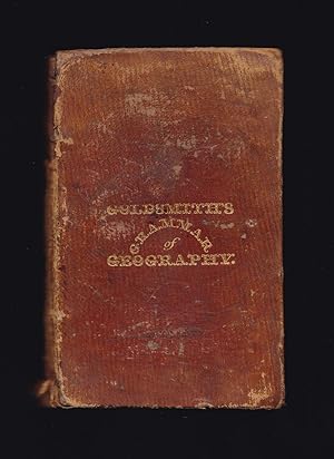
GOLDSMITH'S GRAMMAR OF GEOGRAPHY for the use of schools and young persons with Maps and Engravings
Published by Longman, Rees, Orme, Brown and Green, London, 1827
US$ 89.98
US$ 26.88 shipping
Ships from United Kingdom to U.S.A.Quantity: 1 available
Add to basketHardcover. Condition: Good. Dust Jacket Condition: No Jacket, as Issued. Sydney Hall (maps engraved and drawn by) (illustrator). New Edition. Circa.1827 (dated by first map). Seven folding maps and full-page copper-engravings: Solar and Lunar Eclipse, The Zodiac, The Seasons, Phases of the Moon, Comparative size of Planets, Mariners compass, Theory of the Tides; Vienna, Dutch, Amsterdam; Constantinople, Turks, Rome: London, French, Paris; Lisbon, Madrid; Dublin, Scotch, Edinburgh; Canton, Chinese, Calcutta; Quebec, Indians, Washington; Artificial Globe and Armillary Globe. ***A new edition corrected and modernized. ***Good in original leather boards. Five gilt bordered compartments to spine. Tail of spine frayed and split. Corners of boards worn and bumped. Boards rubbed. Spine worn with top portion missing. Top inner corners of a few rear pages lightly water splashed. Contemporaneous owner's name, place, date to top of contents page: 'William Green, Market Deeping, April 9th 1878.' Owner's name in ink: Green John Deeping London top front pastedown and: R. P. Green, Ness? Deeping to bottom of end of preface and John Green to pages 62 & 63. On rear pastedown contemporaneously in pencil names and places: William Green Market Deeping, Deeping St James, Walter Milford Green Deeping St James, Robert Pearson Green Bow Church Yard London, Arabella Jessie Green. Vignette to title-page. Missing frontispiece? ***Seven folding maps drawn and copper engraved by Sydney Hall, and published by Longman: The World engraved in 1827; please note that the folding Map of Europe is only half complete, half of the map is torn off (still showing Great Britain, Ireland, France and Spain. Map of British Isles torn and creased to edges with small section torn off top right-hand corner removing the Shetland Islands but not the Orkney Islands; Map of Asia not torn - complete; Map of North America torn along one-third of one foldover but complete; map of South America small tear to lower edge - complete; map of Africa complete - has small tear to lower edge. 191 pages plus one-page of publisher's titles to rear. ***Contents: The Solar System, Geographical Definitions, The Whole Earth: Europe: Sweden and Norway, Denmark, Russia, Prussia, Netherlands, Germany: Saxony, Bavaria, Wurtemberg, Hanover, Austria; Turkey in Europe, Ionian Islands, France, Switzerland, Italy, Spain, Portugal, Great Britain and Ireland: England, Wales, Scotland, Ireland, General Summary of Europe; Asia: Asiatic Turkey, Russia in Asia, Chinese Empire: Chinese Proper, Chinese Tartary, Thibet; Japanese Empire, Birman Empire; Hindoostan, Persia, Tartaria, or Independent Tartary, Arabia, Oriental Archipelago, Australasia, Polynesia, General Summary of Asia; America, North America, United States, British Possession in North America, Native Tribes, West Indies; South America, Spanish Republics, Brazil, Guayana; Africa: Egypt, Abyssinia, Barbary, Sierra Leone, Guinea, Caffraria and Cape of Good Hope, Mozambique and Zanguebar, Ajan and Adel Isles; Summary of Africa; General Facts, worthy of being remembered: Physical Geography: seasons and climates, Winds, Earthquakes, Tides, Saltiness of the Sea, Aurora Borealis, Temperature of the Earth, Varieties of the Human Species, Difference of Language and Nation, Difference of Religion, Civilization in its different degrees, Society and forms of Government; Use of the Globes: Problems of the Terrestrial Globe; Problems of the Celestial Globe; etc. ***Turkey in Europe, once the seat of civilization, learning, and the arts, includes ancient Greece and other countries, formerly the finest in the world, but, owing to the Mahometan religion, to the despotism of the government and to the ignorant policy of the Turks, now the most desolate.' ( p 29). ***An early, 1827 antiquarian edition complete in its original leather boards, of interest to collectors of antiquarian maps, antiquarian children's books, geography and travel titles. A scarce pre-Victorian children's book, with all seven maps albeit half of one map torn off as listed above, but unusual to find in the original binding, unrestored.
-
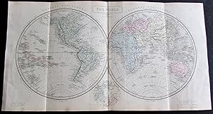
HEMISPHERE MAP OF THE WORLD
Published by LONGMANS LONDON CIRCA 1850, 1850
Seller: Elder Books, Ross on Wye, Herefordshire, United Kingdom
Seller rating 5 out of 5 stars
Map
US$ 62.29
US$ 16.06 shipping
Ships from United Kingdom to U.S.A.Quantity: 1 available
Add to basketNo Binding. Condition: Very Good. AN ORIGINAL MID 19th CENTURY COLOURED MAP OF THE WESTERN & EASTERN HEMISPHERE WITH BLANK REVERSE & MEASURES APPROX 17 X 9 INCHES WITH MARGINS. THREE VERTICAL FOLDS AS PUBLISHED, FEW MINOR MARKS TO MARGINS, OVERALL IN VERY GOOD CONDITION. EXTRA POSTAGE COSTS MAY APPLY TO OVERSEAS ORDERS.
-
Narrative Of The Second Arctic Expedition Made By Charles F. Hall: His Voyage to Repulse Bay, Sledge Journeys to the Straits of Fury and Hecla and to King William's Land, and Residence Among the Eskimos During the Years 1864-'69. Edited by Prof. J. E. Nourse, U.S.N.
Published by Government Printing Office, Washington DC, 1879
Seller: Thomas J. Joyce And Company, Chicago, IL, U.S.A.
Seller rating 2 out of 5 stars

First Edition
Hardcover. Condition: Good. two folding charts at rear, four chromolithographs, two steel engraved portraits, 40 half-page woodcuts, 28 whole page woodcuts (illustrator). First edition. Quarto, l, 644 pages, folding map on linen in rear pocket, recased with original spine in place, new endpapers, large gilt vignette on top cover intact. Hall made three expeditions into the Arctic, each for the purpose of geographical discovery. This is the account of his longest expedition, which heavily involved interaction with the native Inuits. Eight of the sketches of the coast lines were drawn by Inuits. Issued as Senate Executive Doc. 27. Two folding charts in rebuilt rear pocket; four chromolithographs, two steel engraved portraits, 40 half-page woodcuts, 28 whole page woodcuts. Nourse was a professor at the U. S. Naval Academy. He assembled this report from fragments and journals left by Capt. Hall.
-

The Gallery of Literary Morceaux; Combining the Serious with the Lively, and the Gay with the Pathetic
Published by Charles Daly; John Kendrick, London, 1835
Seller: CURIO, Cleethorpes, North East Lincolnshire, United Kingdom
Seller rating 5 out of 5 stars
US$ 269.94
US$ 40.32 shipping
Ships from United Kingdom to U.S.A.Quantity: 1 available
Add to basketHardcover. Condition: Very Good. No Jacket. 3rd Edition. Third Edition. Small hardback (5.5cm x 3.5cm) in full brown leather boards, gold gilt lettering and decoration to spine, gold gilt borders to front/rear boards, no dustjacket as issued. 312pp. B/w portrait frontispiece of 'Sir Walter Scott Bart', marbled endpapers, gold gilt page edges. Not library copy, no inscriptions, number '5' in ink to reverse ffep, split to front spine edge. (24/2).
-
Ireland: its Scenery, Character &c (Vol I, II, III)
Published by Published by How and Parsons, Jeremiah How 184118421843, London, 1841
Seller: Keoghs Books, Skipton, United Kingdom
Association Member: PBFA
Seller rating 5 out of 5 stars
Map First Edition
US$ 346.08
US$ 37.63 shipping
Ships from United Kingdom to U.S.A.Quantity: 1 available
Add to basket, in 3 volumes, 68 engraved plates with titles (including frontispiece to Vol I and III, map of Ireland to Vol II, county maps to each volume), title page with illustrated border to each volume, numerous engravings in text throughout each volume, owner's loose inserts to Vol III (fern fronds) First Edition , slight rubbing to covers, occasional foxing throughout, very good condition , half bound calf with marbled boards, blindstamped decorative rules to covers, gilt titles on labels and rules to spine, pink mottled edges quarto, 25 x 18 cms Hardback ISBN:
-

The Spanish Main; or, Thirty Days on the Caribbean
Published by The Courier Company, Buffalo, NY, 1888
Seller: APPLEDORE BOOKS, ABAA, WACCABUC, NY, U.S.A.
Seller rating 5 out of 5 stars
First Edition Signed
Decorative Cloth. Condition: Near Fine. The author's photographs, engraved by Miss Julia M. Hall (illustrator). First Edition. WARMLY INSCRIBED BY EDWARD T. HALL TO AUTHOR J.T. TROWBRIDGE on the front free endpaper. An exceptionally bright copy to boot of the 1888 1st edition. Tight and Near Fine in its dark-green cloth, with brilliant gilt-titling and design at the front panel and spine. Clean and very well-preserved. Octavo, "illustrations from the author's photographs, engraved by Miss Julia M. Hall. Signed.
-
A Travelling County Atlas: With all the Coach and Rail Roads accurately laid down and coloured and carefully corrected to the present time.
Published by 1842, 1842
Seller: Berkelouw Rare Books, Berrima, NSW, Australia
Association Member: ANZAAB ILAB
Seller rating 4 out of 5 stars

Hardcover. Condition: Very Good. London: Chapman and Hall 1842. 8vo. Orig. full calf (mildly marked) envelope with repaired edges. Gilt titling to cover. Comprising 46 folding engraved maps hand-coloured in outline depicting some projected railway lines never actually constructed. 1st edition of this fascinating atlas. Sidney Hall pioneered the use of the steel engravings in the production of these maps which was completed by his widow after his death in 1831.
-
Plate. 28. : PUNISHMENT OF THE TCHA [le supplice de la La cangue (ou TCHA)], gravure tir�e de : Lord Macartney's Embassy to China, Published in London, 1796. [ Macartney, George (1737-1806) : An Authentic account of an embassy from the king of Great Britain to the emperor of China. taken chiefly from the papers of. the earl of Macartney. by Sir George Staunton. London : G. Nicol, 1796]
Language: French
Published by G. Nicol 179, London
Condition: tr�s bon �tat. Alexander London G. Nicol 1796 une gravure ancienne dessin�e par William Alexander et grav�e en noir par John HALL, Format : 38 x 31 cm, Plate. 28. : Punishment of the Tcha [le supplice de la La cangue (ou TCHA)], gravure tir�e de : Lord Macartney's Embassy to China, Published in London by G. Nicol, 1796. tr�s bon �tat Engraving recording a journey through China .le supplice de la La cangue (ou TCHA), est un ch�timent similaire au pilori en Occident, � la diff�rence que la planche de la cangue n'�tait pas fix�e � une base et devait �tre port�e par le prisonnier . L'Ambassade de Lord Macartney, mission britannique qui s'est rendue en Chine en 1792-1793 pour tenter d'obtenir des relations commerciales et diplomatiques plus favorables pour le Royaume-Uni. Dirig�e par George Macartney, elle a �t� envoy�e par le roi George III aupr�s de l'empereur Qianlong. La mission a �t� marqu�e par une s�rie de malentendus entre les Britanniques et les Chinois, et l'�tat Qing a finalement rejet� toutes les demandes britanniques, un r�sultat qui s'est av�r� �tre l'un des facteurs qui ont contribu� au d�but des guerres de l'opium au XIXe si�cle . superbe GRAVURE . en tr�s bon �tat ( very good condition). William Alexander, engraved by John Hall.
-
Engraved Portrait and signature, of John C. Calhoun, framed in 1924 by Goodpeed's Book Shop, Boston.
Published by 19th Century
Seller: Wittenborn Art Books, San Francisco, CA, U.S.A.
Seller rating 5 out of 5 stars
Manuscript / Paper Collectible
Condition: Good. Engraved portrait and signature of John C. Calhoun, framed in 1924 by Goodpeed's Book Shop, Boston. Framed 11.5 x 9 inches.John C. Calhoun was Monroe's Secretary of War from 1817-1825, Vice President under J.Q. Adams and Jackson (1825-1832), Tyler's Secretary of State (1844-1845), and U.S. Senator from South Carolina (1832-1843, 1845-1850). Richard M. Johnson represented Kentucky in the House of Representatives (1807-1819, 1829-1837) and U.S. Senate (1819-1829) and served as Van Buren's Vice President (1837-1841).