Order Total (1 Item Items):
Shipping Destination:

Janssonius Johannes 1588 1664 (76 results)
Skip to main search results
Product Type
- All Product Types
- Books (8)
- Magazines & Periodicals
- Comics
- Sheet Music
- Art, Prints & Posters (50)
- Photographs
- Maps (18)
-
Manuscripts &
Paper Collectibles
Condition
Binding
- All Bindings
- Hardcover (1)
- Softcover
Collectible Attributes
Free Shipping
Seller Location
Seller Rating
-
![Seller image for Arnoldi Corvini a? Belderen . Ad titulum digestorum de verborum significatione commentarius [Reprint] (1646)[Leatherbound] for sale by S N Books World](https://pictures.abebooks.com/inventory/md/md30703336241.jpg)
Arnoldi Corvini a? Belderen . Ad titulum digestorum de verborum significatione commentarius [Reprint] (1646)[Leatherbound]
Published by Pranava Books, 2020
Book Print on Demand
Leatherbound. Condition: NEW. Leatherbound edition. Condition: New. Language: lat Leather Binding on Spine and Corners with Golden leaf printing on spine. Reprinted from 1646 edition. NO changes have been made to the original text. This is NOT a retyped or an ocr'd reprint. Illustrations, Index, if any, are included in black and white. Each page is checked manually before printing. As this print on demand book is reprinted from a very old book, there could be some missing or flawed pages, but we always try to make the book as complete as possible. Fold-outs, if any, are not part of the book. If the original book was published in multiple volumes then this reprint is of only one volume, not the whole set. IF YOU WISH TO ORDER PARTICULAR VOLUME OR ALL THE VOLUMES YOU CAN CONTACT US. Sewing binding for longer life, where the book block is actually sewn (smythe sewn/section sewn) with thread before binding which results in a more durable type of binding. THERE MIGHT BE DELAY THAN THE ESTIMATED DELIVERY DATE DUE TO COVID-19. Pages: 436 Pages: 436.
-

La Principaute d'Orange et comtat de Venaissin. Amstelodami 1627.
Seller: Antiquariat Dasa Pahor GbR, M�nchen, Germany
Seller Rating:

Map
Zeigt Departement Vaucluse in Provence-Alpes-C�te d'Azur in Frankreich. Rank kaum gebr�unt, mit kleinen Einrissen, ansonsten gut erhalten. Shows the departement Vaucluse in Provence-Alpes-C�te d'Azur in France. White margins slightly age-toned, with tiny tears, otherwise in a good condit.
-
Condition: -. Gefaltete alt-kolorierte Kupferstich-Karte. Blattma�: 61 x 47 cm. Mit kleinem Riss im unterem Rand. Alterbedingt leicht gebr�unt. Fotos gerne auf Anfrage.
-
[NETHERLANDS - GELDERLAND]. Ducatus Gelriae pars tertia qu� est comitatus Zutphaniensis
Seller: Antiquariat Dasa Pahor GbR, M�nchen, Germany
Seller Rating:
Map
Detailed map of Gelderland in the Netherlands with Zutphen in the middle.
-
Original-Kupferstichkarte mit einer dekorativen Titel-Kartusche (aus: Novus Atlas, ca. 1657), Abbildung: 37,5 x 47,5 cm; gut erhaltenes Blatt. - / Johannes Janssonius (1588 1664) niederl�ndischer Kartograf, Verleger und Grafikh�ndler. Gewicht in Gramm: 1200.
-
Territorium Norimbergense - Karte im Kupferstich von N�rnberg, Umgebung und separatem Stadtplan
Book
(um 1640). Ma�e: ca. 46,5 cm x 36,5 cm, unten links mit Posaune blasendem Engel und Wappen gekr�nte Titelkartusche sowie seitlich geschm�ckter Staffage, hinter Glas, in vergoldeter Holzleiste, (Mittelfalz unten, au�erhalb des Plattenrandes hinterlegt/etwas fleckig/leicht gebr�unt)---- Johann Janssonius, eigentlich Jan Janszoon, war ein niederl�ndischer Kartograph, Verleger und Hersteller von Globen - 2090 Gramm.
-
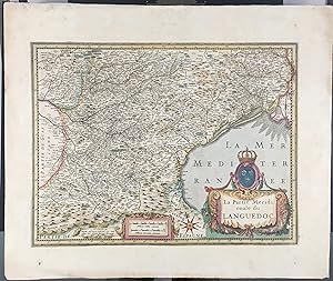
Pas de couverture. Condition: Bon. Pas de jaquette. Edition originale. France, gravure carte ancienne colori�e "La partie M�ridionale du LANGUEDOC", planche 50 x 60 cm, image 37,5 x 49,5 cm. Publi�e � Amsterdam en 1638 par Johannes Janssonius, imprim�e par Henr� Hondius/Janssonius, ( Gerard Mercator, Jodocus Hondius, Henricus Hondius, Joannes Janssonius) et vendue � Paris par Melchior Tavernier ( 1594-1665). Cartouche de titre avec les armes du roi de France, �chelle militaire en milles et petit cartouche Amsterdam. Texte dos en latin. Extraite de Carte du Nouvel Atlas ou Th��tre du Monde, comprenant Les Tables & Descriptions de la France, Suisse & du Pays Bas, Amsterdam. Cette carte est d�limit�e par la Catalogne � l'ouest et la Camargue � l'Est, l'Albigeois et le Rouergue au Nord. Narbonne, B�ziers, Albi, Toulouse, Montpellier, Albi, Limoux, Carcassonne, Castres,
-
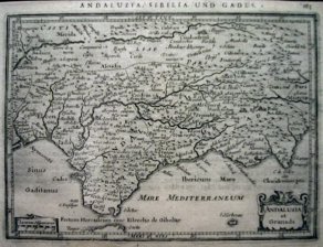
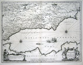
Condition: ACEPTABLE. Andaluzia, Sibilia und Gades (2) Formato (cm): 19x14.
-
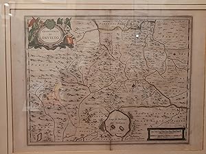
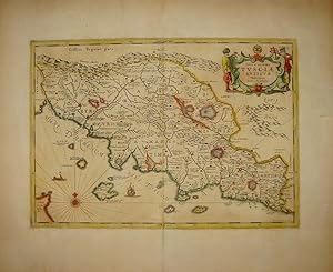
UMBRIA - TERRITORIO DI ORVIETO.
Publication Date: 1640
Seller: LIBRERIA ANTIQUARIA SACCHI SAS, Firenze, Italy
Seller Rating:

Signed
senza rilegatura. Condition: buono. Amstelodami, Apud Ioannem Iassonium, 1640. Misura: mm. 500x390; incisione in rame con coloritura coeva, in alto a sinistra in cornice, titolo "Territorio di Orvieto", in basso a destra scala milliaria Italica e Germanica communia. Al verso testo in lingua Francese e antichi segni di precedente attaccatura (probabile scotch), sulla piega centrale, visibili solo al verso del foglio. Carta geografica molto dettagliata. Codice inv.1008482 La carta, firmata da Janssonius, appare per la prima volta nel "Theatrum Italiae in Eius Regna Dominia", edito da Hendrick Hondius nel 1636 e contenente molte mappe di Jodocus Hondius e Jan Janssonius. L'opera presenta ben 39 nuove carte dell'Italia, tra le quali questa di Orvieto. Successivamente la carta � inserita negli atlanti di Hondius e Janssonius. Edizione con il testo francese. Bibliografia: Koeman Me 43, 391." The paper, signed by Janssonius, appears for the first time in "Theatrum Italiae in Eius Regna Dominia" edited by Hendrick Hondius in 1636 and containing many maps by Jodocus Hondius and Jan Janssonius. Autografato dall'autore.
-

Latium
Published by Amsterdam, 1652
Seller: Libreria Ex Libris ALAI-ILAB/LILA member, Roma, Italy
Seller Rating:
Map
Carta geografica originale (cm. 49x36 pi� ampi margini bianchi). Coloritura antica all'acquarello. Ottimo esemplare.
-
Nigritarum regnum
Published by Amsterdam 1690 ca., 1690
Seller: Libreria Ex Libris ALAI-ILAB/LILA member, Roma, Italy
Seller Rating:
Map
Incisione originale su rame (cm. 56,5x43 pi� ampi margini) edita da G. Valk e P. Schenk. Coloritura coeva all'acquarello. Ottimo esemplare.
-
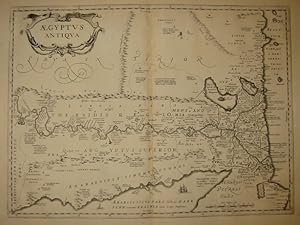
Aegyptus antiqua
Published by Amsterdam, 1700
Seller: Libreria Ex Libris ALAI-ILAB/LILA member, Roma, Italy
Seller Rating:
Map
Incisione originale su rame (cm. 50,5x37 pi� ampi margini). Ottimo esemplare.
-

Imperium Caroli Magni
Published by Amsterdam, 1700
Seller: Libreria Ex Libris ALAI-ILAB/LILA member, Roma, Italy
Seller Rating:
Map
Carta geografica originale (cm. 52,5x37,5 pi� ampi margini). Ottimo esemplare.
-
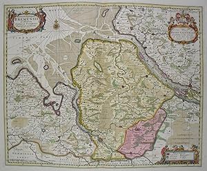
Ducatus olim Episcopatus Bremensis et ostiorum Albis et Visurgis Fluviorum novissima Descriptio
Publication Date: 1682
Map
Kein Einband. Condition: Sehr gut. Es handelt sich hierbei um eine originale, kolorierte Kupferstich-Landkarte des Gebiets von Bremen und Niedersachen von Johannes Janssonius (1588 - 1664) bei Gerard Valk (1650 - 1726) und Petrus Schenk aus dem Jahr 1682. *** Titel: Ducatus olim Episcopatus Bremensis et ostiorum Albis et Visurgis Fluviorum novissima Descriptio *** Gebiet bzw. Ort: Bremen, Niedersachen in Norddeutschland *** Kartograph: Johannes Janssonius (1588 - 1664), gedruckt bei Moses und Humby, verlegt von Gerard Valk (1650 - 1726) und Petrus Schenk *** Jahr: 1682 *** Gr��e des Plattenbereichs: 42,5 x 52.5 cm *** Technik: Kupferstich *** Zustand (Perfekt/ Sehr gut/ Gut/ Ordentlich/ M��ig/ Schlecht): In sehr gutem Erhaltungszustand *** Bemerkungen: - - - - International buyers welcome. If you have any questions, please don't hesitate to ask. --- Auf Wunsch stellen wir Ihnen gerne ein kostenfreies Echtheitszertifikat aus --- If you wish, we will gladly provide a certificate of authenticity free of charge ---.
-
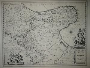
Capitanata olim Mesapia et Iapygiae pars
Published by Amsterdam 1650 ca., 1650
Seller: Libreria Ex Libris ALAI-ILAB/LILA member, Roma, Italy
Seller Rating:
Map
Incisione originale su rame (cm. 48,5x37,5 pi� ampi margini). Ottimo esemplare.
-
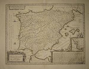
Hispaniae veteris descriptio.
Published by Amsterdam, 1700
Seller: Libreria Ex Libris ALAI-ILAB/LILA member, Roma, Italy
Seller Rating:
Map
Carta geografica originale (cm. 48,5x37 pi� ampi margini). Ottimo esemplare.
-
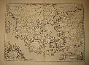
Hellas seu Graecia Sophiani
Published by Amsterdam, 1700
Seller: Libreria Ex Libris ALAI-ILAB/LILA member, Roma, Italy
Seller Rating:
Map
Incisione originale su rame (cm. 49x36 pi� ampi margini). Ottimo esemplare.
-
Nova & accurata Tusciae antiquae Descriptio Autore Ab. Ortelio
Published by Amsterdam, 1649
Seller: Libreria Ex Libris ALAI-ILAB/LILA member, Roma, Italy
Seller Rating:
Map
Carta geografica originale (cm. 48,5x34 pi� ampi margini bianchi). Bella coloritura antica all'acquarello. Ottimo esemplare.
-
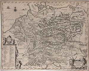
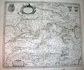
Condition: ACEPTABLE. En el qual se contienen los Mapas, y Definiciones de Germania la Alta, o Alemania, y de sus partes. Frontispicio de la segunda parte del primer tomo del Nuevo Atlas o Teatro de Todo el Mundo publicado en espa�ol en Amsterdam. Formato (cm): 49'5x30.
-
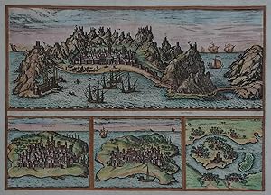
Kein Einband. Condition: Gut. Es handelt sich hierbei um einen originalen, kolorierten Kupferstich mit Ansichten der St�dte Aden, Mombasa, Kilwa und Sofala von Johannes Janssonius nach Braun und Hogenberg. *** Titel: Aden - Mombaza - Quiloa - Cefala *** Gebiet bzw. Ort: Aden (Jemen) - Mombasa (Kenia) - Kilwa (Kongo) - Sofala (Mosambik) *** Kartograph: Johannes Janssonius (1588 - 1664) nach Frans Hogenberg (1535 � 1590) / Georg Braun (1541 � 1622) *** Jahr: 1657 *** Gr��e des Plattenbereichs: 34 cm x 48 cm *** Technik: Kupferstich *** Zustand (Perfekt/ Sehr gut/ Gut/ Ordentlich/ M��ig/ Schlecht): In gutem Erhaltungszustand. In wenigen Bereichen sehr leicht gebr�unt. Mittelfalte hinterlegt. *** Bemerkungen: Dekorativer und sehr seltener Kupferstich mit Ansichten von vier bedeutenden Hafenst�dten in Arabien und Ostafrika. Diese dienten den europ�ischen Kaufleuten, die Seehandel mit dem fernen Osten betrieben, als unverzichtbare Versorgungsh�fen bei der Umfahrung Afrikas. Der Kupferstich erschien zun�chst ab dem Jahr 1572 in Braun und Hogenbergs 'Civitates Orbis Terrarum'. Im Jahr 1653 �bernahm Johann (Jan) Janssonius eine gro�e Anzahl der Kupferstichplatten und druckte eine kleine Anzahl der hier vorliegenden, etwas �berarbeiteten Variante f�r sein 'Theatrum urbium'. - - - International buyers welcome. If you have any questions, please don't hesitate to ask. - - - ----- Auf Wunsch stellen wir Ihnen gerne ein kostenfreies Echtheitszertifikat aus ------ If you wish, we will gladly provide a certificate of authenticity free of charge ---.
-
Condition: ACEPTABLE. (5) Atlas Novus Mapas muy similares a los de Blaeu, expecto peque�as diferencias. Continuaci�n y ampliaci�n del Atlas de Hondius Formato (cm): 50x41.
-
Condition: ACEPTABLE. Amstelodami Apud Ioannem Ianssonium Formato (cm): 47x41.
-
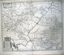
Condition: ACEPTABLE. Cotestani. Ptol. / Edentani Plin. Atlas Novus Mapas muy similares a los de Blaeu, expecto peque�as diferencias. Continuaci�n y ampliaci�n del Atlas de Hondius Formato (cm): 48x35.
-
Condition: ACEPTABLE. (4) Atlas Novus Mapas muy similares a los de Blaeu, expecto peque�as diferencias. Continuaci�n y ampliaci�n del Atlas de Hondius Formato (cm): 50x38.
-
Condition: ACEPTABLE. Amstelodami Excudit Ioannes Ianssonius Formato (cm): 54x39.
-
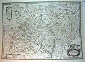
Condition: ACEPTABLE. Dedicada a los Illustrissimos Sennores Diputados del Reyno de Arragon D. Juan Briz Martinez Abbade. Authore Ioanne Baptista Labanna Atlas Novus Mapas muy similares a los de Blaeu, expecto peque�as diferencias. Continuaci�n y ampliaci�n del Atlas de Hondius Formato (cm): 55x45.
-
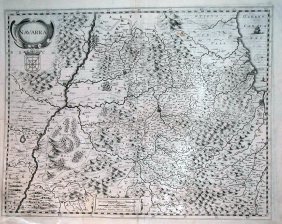
Condition: ACEPTABLE. Atlas Novus Mapas muy similares a los de Blaeu, expecto peque�as diferencias. Continuaci�n y ampliaci�n del Atlas de Hondius (2) Formato (cm): 49x38.
-

Condition: ACEPTABLE. Atlas Novus Mapas muy similares a los de Blaeu, expecto peque�as diferencias. Continuaci�n y ampliaci�n del Atlas de Hondius Formato (cm): 50x42.
-
Condition: ACEPTABLE. (5) Atlas Novus Mapas muy similares a los de Blaeu, expecto peque�as diferencias. Continuaci�n y ampliaci�n del Atlas de Hondius Formato (cm): 50x41.
-
Condition: ACEPTABLE. Mapa antiguo original de Johannes Janssonius, estampado para la obra Theatrum Orbis Terrarum � Novus Atlas, que posteriormente sigui� public�ndose dentro del Atlas Maior, publicado en lat�n, franc�s, holand�s y espa�ol, trat�ndose en este caso concreto de un ejemplar de la edici�n latina. La obra consta de 600 mapas dobles y 3.000 p�ginas de texto. Fue el libro mas grande y costoso publicado en el siglo XVII. Bellamente iluminados a mano de �poca. Medidas aproximadas de 53 x 51 cms. Alg�n peque�o desperfecto o restauraci�n antigua en pliegue central en la zona del margen inferior sin afectar zona impresa del mapa. Formato (cm): 51x53.