Order Total (1 Item Items):
Shipping Destination:

Johann Baptist Homann, First Edition (10 results)
Skip to main search results
Product Type
- All Product Types
- Books (7)
- Magazines & Periodicals
- Comics
- Sheet Music
- Art, Prints & Posters (1)
- Photographs
- Maps (2)
-
Manuscripts &
Paper Collectibles
Condition
- All Conditions
- New
- Used
Binding
- All Bindings
- Hardcover (1)
- Softcover
Collectible Attributes
- First Edition
- Signed (1)
- Dust Jacket
- Seller-Supplied Images
- Not Printed On Demand
Seller Location
Seller Rating
-
![Seller image for [Portfolio]: Antique Maps of the World in Color for sale by Between the Covers-Rare Books, Inc. ABAA](https://pictures.abebooks.com/inventory/md/md31614799540.jpg)
[Portfolio]: Antique Maps of the World in Color
Published by Sterling Publishing House, Co., Inc, New York, 1960
Seller: Between the Covers-Rare Books, Inc. ABAA, Gloucester City, NJ, U.S.A.
Association Member: ABAA ESA ILAB IOBA
Seller Rating:

First Edition
Unbound. Condition: Very Good. Portfolio. Color facsimiles of 36 historical maps. Each map measures approximately 12" x 9", printed on 17" x 11�" paper with descriptive text in the left margin. Housed with a title page sheet and unprinted top sheet in a four-fold chemise. Unprinted topsheet sunned at the edges, first two leaves with some very light toning and a couple of tiny corner creases; the maps are otherwise bright and fine. The chemise is good only with toning, wear, and soil, and a 1" creased tear on the cover panel. A nice production, and the chemise has done its job, keeping the maps bright and fresh.
-
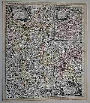
Bavariae pars superior tam in sua Regimina Principaliora quam in eorundem Praefecturas Particulares accurate divisa. Rechts oben eine Insetkarte/Nebenkarte mit der Herrschaft Burghausen und dem Gebiet zwischen Passau und Braunau. Links oben die Titelkartusche. Unten rechts Kartusche mit Wappen, Allegorien und Meilenzeiger. Plattengr��e ca. 50 x 59 cm.
Published by Norimbergae / N�rnberg: Ioh Baptista Homanno, 1729
Map First Edition
[Verso an den R�ndern Reste einer ehemaligen Montage, im ehemaligen Passepartoutausschnitt leicht gebr�unt, verso teil gebr�unt, mit dem originalem Mittlfalz]. Sch�ne, im Ganzen wohlerhaltene Karte von Oberbayern mit M�nchen etwa im Zentrum der Blattes. 32850 gr.
-
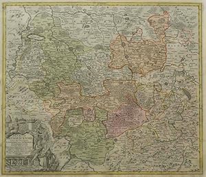
Ducatus Brunsuicensis in tres Principatus Calenbergicu feilicet & Grubenhag Guelpherbitanum distincte divisi nec non Episcopates Hilesiensis, Pr. Halber. Comitatus Schauenburgici aliorumq.
Published by Johann Baptist Homann ohne Jahr.
Book First Edition
1. Aufl. altkolorierter Kupferstich 50,3 x 59 cm unter Passpartout, fachm�nnisch gerahmt, sehr gut Sprache: Deutsch Gewicht in Gramm: 550.
-

Peloponesus hodie Moreae regnum in omnes suas Provincias Veteres et Hodiernas accurate divisum (map of the Peloponnese and surrounding mainland and islands, including Cephalonia)
Published by Homann, N�rnberg (Nuremberg), 1730
First Edition
A stunning antique map with original full color, in excellent condition. 49.5 x 59 cm (plate), 52.5 x 60.5 cm (sheet). Printed on fine laid paper. Verso blank. Archival tape reinforcement to edges of verso. In perfect condition, with the colors very fresh.
-
Geographische Universal-Zeig Und Schlag-Uhr
Published by Nurnberg: J.B. Homann, early 18 cent.
Art / Print / Poster First Edition
No Binding. Condition: Very Good. 1st Edition. A hand coloured engraved map of California represented as an island. The mistake was made in the middle of the 17th century by the exploring cartographers. The map is centered at the North Pole, which is represented as a center of the Universe, surrounded by Zodiac, Roman figures, and depicted as a clock face. The clock is a novelty created by Zacharias Landteck to resolve the marine navigation issues with changing the longitude. Johann Baptist Homann was a prominent Bavarian geographer and a founder of the publishing house Homann and Heirs. Text in Deutsch. 61x53 cm. Engraving, water colours. Unrecognized water mark on the paper. Creasings to the upper corners. Occasional foxing, minor soiling. Very good to near fine.
-
Topographische Vorstellung der Neuen Russischen Haupt-Residenz und See-Stadt St. Petersburg samt ihrer zu Erst Aufgerichten Vestug
Publication Date: 1720
Book First Edition
Pas de couverture. - s.d. (circa 1720), 63,2x53cm, une feuille rempli�e. - Carte originale rehauss�e en couleurs. En haut � gauche un cartouche montre la r�gion de Saint Petersbourg et la Neva. Tr�s grand cartouche all�gorique de titre en haut � droite. Un m�daillon au centre � droite montre le Fort Alexandre de Kronstadt. Bel exemplaire. [ENGLISH DESCRIPTION ON DEMAND].
-

Atlas methodicus explorandis juvenum profectibus in studio geographico ad methodum H�bnerianam. Methodischer Atlas. Das ist Art und Weise, wie die Jugend in Erlernung der Geographie f�glich examiniret werdenkan / nach H�bnerischer Lehr-Art.
Published by N�rnberg, Johann Baptist Homann, 1719., 1719
Seller: Charbo's Antiquariaat, Amsterdam, Netherlands
Seller Rating:
First Edition
Folio. (15) text pages (intro & index). With additional engraved title & 18 double page hand-col. engr. maps, printed on one side. Hardcover. Contemp. half vellum and paste-paper boards with flower decoration. VG. (Binding rather rubbed; fore-edge of title leaf a bit frayed; num. early inscriptions on text pages; small hole in margin of Africa map). * First edition of one of the earliest school atlases to use a system of letters on blind maps that refer to the index in front of the atlas. Incl. 4 celestial maps on one leaf, maps of both hemispheres (incl. part of Australia), Europe, Asia, Africa, the Americas (with California as an island), and 12 maps of European countries.
-
Nova Anglia Septentrionali Americae implantata Anglorumque coloniis florentissima Geographica exhibita
Publication Date: 1716
Book First Edition
Pas de couverture. - Nuremberg s.d. (circa 1716), 61,4x53cm, une feuille rempli�e. - Edition originale et second tirage de cette carte � toutes marges, grav�e sur cuivre et rehauss�e en couleurs � l'�poque. La carte est apparue pour la premi�re fois dans l'Atlas Novus vers 1716 et a �t� r��dit�e pendant plusieurs d�cennies. Beau cartouche en bas � droite t�moignant des �changes commerciaux entre Am�rindiens et Europ�ens : perles, armes, outils, alcool, textiles et fourrures, l'un des piliers �conomiques de la Nouvelle-Angleterre � l'�poque. Cette carte tr�s d�taill�e couvre la zone g�ographique allant de Philadelphie au Sud jusqu'� la vall�e du Saint-Laurent au Nord et indique les colonies am�rindiennes et europ�ennes. Elle couvre les Etats du Maine, du New Hampshire, du Vermont, du Massachusetts, du Connecticut, du Rhode Island, de New York et de Pennsylvanie et du New Jersey. Bel exemplaire de l'une des rares cartes du Nord-Est am�ricain du d�but du XVIII�me si�cle, repr�sentant la r�gion telle qu'elle �tait envisag�e avant que le gouvernement britannique ne commande des �tudes cartographiques plus approfondies sur le sujet. Cette carte est l' uvre de Johann Baptist Homann (1664-1724), l'un des cartographes les plus renomm�s, fondateur de l'une des plus importantes maisons d'�ditions allemandes. Con�ue alors que la r�gion �tait toujours en cours d'explorations, elle montre un certain nombre d'inexactitudes : Cape Cod y est repr�sent�e comme une �le et le port de Boston appara�t plus grand que son apparence r�elle. La taille de certains lacs est exag�r�e, tandis que le lac Champlain plus � l'Est que son emplacement r�el. Le lac Seneca (�tat de New York) se r�v�le �tre une immense mer qui se d�verse dans la vall�e de l'Hudson et le lac George porte alors le nom de � lac iroquois �. La repr�sentation de la Nouvelle-France au Nord est elle aussi inexacte dans la mesure o� Montr�al (Mont Royal) prend la forme d'une �le immense imm�diatement adjacente au lac Ontario. On notera �galement la pr�sence de la colonie l�gendaire de Norumbega. Il s'agit en outre de l'une des toutes premi�res repr�sentations de la ville de New York : Manhattan est identifi�e comme une �le l�gend�e � N. Loch �, ce qui aide � identifier cette carte comme deuxi�me �tat. Tr�s bel exemplaire. [ENGLISH TRANSLATION FOLLOWS] Nova Anglia Septentrionali Americae implantata Anglorumque coloniis florentissima Geographica exhibita Nuremberg | [ca 1716] | 61.4 x 53 cm | one map Beautiful copy of one of the rare maps of the American North-East in the early eighteenth century, showing the region as it was considered before the British government commissioned more in-depth cartographic studies on the subject. his map is the work of Johann Baptist Homann (1664-1724), one of the most well-known cartographers, founder of one of the most important German publishing houses. Conceived while the region was still being discovered, it shows a certain number of inaccuracies: Cape Cod is represented as an island and the port of Boston appears larger than its true size. The size of some lakes is exaggerated, whereas Lake Champlain is farther east that its actual location. Seneca Lake (New York State) is shown to be an immense sea that flows into the Hudson Valley and Lake George is then called �Lake Iroquois.� The representation of New France in the North is also inaccurate insofar as Montreal (Mont Royal) takes the shape of a huge island immediately adjacent to Lake Ontario. We also note the presence of the legendary Norumbega colony. It is also one of the very first representations of New York City: Manhattan is identified as an island captioned �N. Loch,� which helps to identify this map as a second state. Very beautiful copy.
-
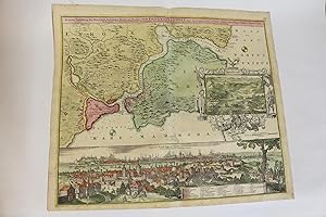
Accurate Vorstellung der Orientalisch- Kayserlichen Haupt- und Residenz-Stadt Constantinopel - Carte de Constantinople
Publication Date: 1720
Book First Edition
Pas de couverture. - s.d. (circa 1720), 62x53,5cm, une feuille rempli�e. - Carte originale, enti�rement rehauss�e en couleurs, montrant la r�gon du Bosphore. Grande vue panoramique de Constantinople vue de Scutari en bas de la carte. Une l�gende nomme et localise 30 b�timents importants, tels que le S�rail, Sainte-Sophie et plusieurs mosqu�es. Une vue de l'Hellespont, de la mer de Marmora et de Constantinople au loin, se trouve en haut � droite de la carte. Bel exemplaire de cette carte con�ue par Johann Baptist Homann (1664-1724) - l'un des cartographes les plus renomm�s et fondateur de l'une des plus importantes maisons d'�ditions allemandes. [ENGLISH DESCRIPTION ON DEMAND].
-
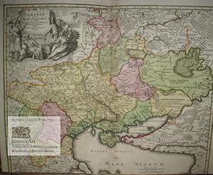
Ukrania quae et Terra Cosaccorum cum vicinis Walachiae, Moldaviae, Minorisq., Tartariae provinciis exhibita a Ioh. Baptista Homanno Noribergae. Gro�e Landkarte der Ukraine und der Kosaken-Gebiete in der Walachei, Moldawien, Kleinasien und den Provinzen der Tartaren von Homann um 1720
Published by N�rnberg: Johann Baptist Homann im Selbstverlag ohne Jahresangabe (um ), 1720
Seller: historicArt Antiquariat & Kunsthandlung, Wiesbaden-Breckenheim, Germany
Seller Rating:
Map First Edition Signed
1. dekorativer Original-Kupferstich von Johann Baptist Homann (1664-1724) auf Imperial-Folio, in der Platte signiert, auf r�ckseitig unbedrucktem schweren B�ttenblatt, Plattengr��e ca. 47 x 58 cm (H�he x Breite), in der Mitte einmal gefaltet, pr�chtige Titelkartusche oben links mit Pfeife rauchenden Kosaken und Tartaren in Waffen und Tracht, Reiterheer und Kamel im Hintergrund, deutscher und polnischer Meilenzeiger am unteren Blattrand, oben das Palatinat Moskau, unten das Schwarze Meer bis Constantinopel, das Asowsche Becken und die Halbinsel Krim, Mittelfalz mit kleinen sauber hinterklebten Einrissen und einem kleinen hinterklebten Loch im oberen Kartenrand links neben der Mittelfalz, unten bis an den Plattenrand mit geringem Verlust der bildlichen Darstellung (ca. 0,5 cm) beschnitten, pr�chtig und sehr geschmackvoll von alter Hand fl�chenkoloriert und insgesamt bemerkenswert gut erhalten, von gro�er Seltenheit eine der seltesten und pr�chtigsten Karten Homanns, publiziert kurz vor seinem Ableben, sehr detailreiche und pr�chtig altkolorierte Darstellung der ehemaligen Ukraine, der Walachei, Moldawiens, Klein-Asiens, der T�rkei, Russlands und des heutigen Polens, von Moskau im Norden bis zum Schwarzen Meer, der Krim-Halbinsel und der Stadt Constantinopel im S�den, einschlie�lich der Gebiete der Kosaken und Tartaren - very large and heavy item, please ask for additional shipping costs before you order - gro�er und/oder schwerer Artikel mit zus�tzlichen Kosten f�r Versand und Versicherung - heavy and/or oversized item with additional costs for shipping and insurance - please ask us before you order this article 2100 gr.