Order Total (1 Item Items):
Shipping Destination:

Vietnam Maps (2 results)
Skip to main search results
Search filters
Product Type
- All Product Types
- Books (2)
- Magazines & Periodicals (No further results match this refinement)
- Comics (No further results match this refinement)
- Sheet Music (No further results match this refinement)
- Art, Prints & Posters (No further results match this refinement)
- Photographs (No further results match this refinement)
- Maps (No further results match this refinement)
- Manuscripts & Paper Collectibles (No further results match this refinement)
Condition Learn more
- New (No further results match this refinement)
- As New, Fine or Near Fine (No further results match this refinement)
- Very Good or Good (No further results match this refinement)
- Fair or Poor (No further results match this refinement)
- As Described (2)
Binding
- All Bindings
- Hardcover (No further results match this refinement)
- Softcover (No further results match this refinement)
Collectible Attributes
- First Edition (No further results match this refinement)
- Signed (No further results match this refinement)
- Dust Jacket (No further results match this refinement)
- Seller-Supplied Images (2)
- Not Print on Demand (2)
Language (1)
Price
- Any Price
- Under US$ 25 (No further results match this refinement)
- US$ 25 to US$ 50 (No further results match this refinement)
- Over US$ 50
Free Shipping
- Free Shipping to U.S.A. (No further results match this refinement)
Seller Location
Seller Rating
-
Khanh Hu'ng and Quan Long Vietnam. Series 1501 AIR. Sheets NC 48-10 & 11. Edition 2.
Published by Army Map Service., Washington, D.C., 1967
Seller: Asia Bookroom ANZAAB/ILAB, Canberra, ACT, Australia
Association Member: ANZAAB ILAB
Seller rating 5 out of 5 stars

Two printed colour adjoining maps 73 x 55.6 cms and 55.6 x 73 cms, original folds, inked operational annotations to the Quan Long sheet, multiple marginal legends noting aerodromes and radio facilities, roads, railroads and boundaries, glossary of terms, much of the text is in both English and Vietnamese, in very good condition. Detailed U. S. Army maps of the Mekong Delta and Southern Vietnam, extending from Rach Gia in the north to the area just south of Quan Long (Ca Mau) in the south and east including BacLieu and CanTho. The island of Con son is at lower right of the Khanh Hu'ng sheet. Operational notes are inked around Quan Long are marked and the U Minh Forest, the impenetrable "forest of darkness" is noted in ink. .
-
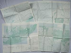
A Series of Five Adjoining Vietnam War Era Maps.
Published by Army Map Service. 1967-1968., Washington, D.C., 1967
Seller: Asia Bookroom ANZAAB/ILAB, Canberra, ACT, Australia
Association Member: ANZAAB ILAB
Seller rating 5 out of 5 stars
Five printed colour adjoining topographic maps (folded), legends to physical features including roads some including footpaths or trails, railroads, rivers, streams, lakes, mountains, boundaries and place names, Route Markers, Railroads, airfields, bridges and detailed terrain, a few including tea plantations, rice fields, coffee and rubber plantations. glossary of Vietnamese terms, in very good unused condition: 1. Special Use S.E. Asia. Xuat-Banlan Thu. Sheet 6026. Series L607. Map 57.3 x 73 cms (sheet), inset map of Hon Khoai Island; 2. Special Use S.E. Asia. Sheet 5927. Series L607. Khoang Cach Deu Vong Cao-DQ. Map 72.3 x 57.3 cms (sheet). he Viet Cong stronghold of Quan Long (C� Mau) is shown; 3. Special Use S.E. Asia. Sheet 6027. Series L607. Vietnam. Map 72.3 x 57.3 cms (sheet), legend showing boundaries, villages, elevation and hydrographic data, glossary of Vietnamese terms, in very good unused condition. Southeast Vietnam and the Mekong delta. The town of V?nh L?i (B?c Li�u) is at the mid right edge of map.; 4. Special Use S.E. Asia. Sheet 6028. Series L607. Vietnam. Do Cao Toi-da Duoi 5 met. Map 54.5 x 54.5 cms 73.3 x 56.6 cms (sheet); 5. Special Use S.E. Asia. Sheet 5928. Series L607. Vietnam. Hon Rai. Map 55 x 55 cms 74.3 x 56.7 cms (sheet), inset map of Hon Rai. The caption has the note: "Dense forest or jungle indicates more than 25% of ground is concealed by canopy with undergrowth generally impassable on foot". Detailed topographic maps in unusually fine condition, of Central and Southern Vietnam issued during the Vietnam War by the United States Corps of Engineers.