Order Total (1 Item Items):
Shipping Destination:

G�ographie Moderne Introduction Ouvrage Utile by Clouet 1730 (2 results)
Skip to main search results
Search filters
Product Type
- All Product Types
- Books (2)
- Magazines & Periodicals (No further results match this refinement)
- Comics (No further results match this refinement)
- Sheet Music (No further results match this refinement)
- Art, Prints & Posters (No further results match this refinement)
- Photographs (No further results match this refinement)
- Maps (No further results match this refinement)
- Manuscripts & Paper Collectibles (No further results match this refinement)
Condition Learn more
- New (No further results match this refinement)
- As New, Fine or Near Fine (No further results match this refinement)
- Very Good or Good (2)
- Fair or Poor (No further results match this refinement)
- As Described (No further results match this refinement)
Binding
- All Bindings
- Hardcover (2)
- Softcover (No further results match this refinement)
Collectible Attributes
- First Edition (2)
- Signed (1)
- Dust Jacket (No further results match this refinement)
- Seller-Supplied Images (2)
- Not Print on Demand (2)
Language (1)
Price
- Any Price
- Under US$ 25 (No further results match this refinement)
- US$ 25 to US$ 50 (No further results match this refinement)
- Over US$ 50
Free Shipping
- Free Shipping to U.S.A. (No further results match this refinement)
Seller Location
Seller Rating
-
G�ographie moderne avec une introduction: ouvrage utile a tous ceux qui veulent se perfectionner dans cette science, on y trouve jusqu'aux notions les plus simples dont on a facilit� l'intelligence par des figures pour le mettre a la port�e de tout le monde, chaque carte a sur les marges l'explication de ce qu'elle renferme, la m�thode qu'on y suit a pour objet de developper les connoissances qui tiennent a l'histoire, ce qui rend cette g�ographie tres interessante. Dedi�e A Messieurs De L'Academie Royale Des Sciences Et Belles-Lettres De Rouen.Par Mr. l'Abbe Clouet de la meme Academie Avec Approbation Et P. Du R - 1767 First edition
Published by Paris: Mondhare., 1767
Seller: Wittenborn Art Books, San Francisco, CA, U.S.A.
Seller rating 5 out of 5 stars

First Edition Signed
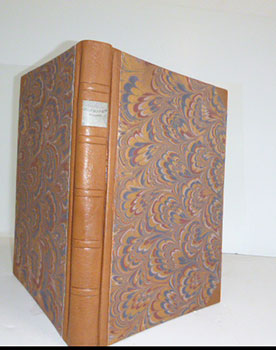
Condition: Good. Folio. 30.4 x 43cm. Contemporary roan restored and with new marbled endpapers by the artisan binder Sasha Mosalov. This first edition very rare; only the 2nd edition is in OCLC Number: 63917404. More common is the 1787 edition. Contemporary handcoloring on the 68 double page maps; pages on hinges. .In-folio basane brune, dos � nerfs orn� (reliure de l'�poque). . Titre frontispice illustr� grav�, d�dicace grav�, un feuillet de table grave, et 68 planches (dont 7 planches de sph�res et 61 cartes), toutes grav�es � double page et aquarell�es � l'�poque, avec colonnes de texte sur les c�t�s. Cartes : Europe (3), Asie (3), Am�rique (3), Afrique (3), France (7), etc. References: P661; Moreland & Bannister p.138School Atlas.This is an unusually thorough teaching atlas for the period: each map has marginal text on both sides which explains the function of the map - topographical, historical, political, etc. Because of its comprehensiveness, this atlas must have been used by advanced students of geography. Editions were published in 1767, 1780, 1787, 1791, 1793. Clouet also published a set of wall maps of the Continents between 1776 and 1793. Full color. Covers are purple marbled paper covered boards with a new leather spine stamped with the title "Clouet Atlas" in gilt.
-
G�ographie moderne avec une introduction: ouvrage utile a tous ceux qui veulent se perfectionner dans cette science, on y trouve jusqu'aux notions les plus simples dont on a facilit� l'intelligence par des figures pour le mettre a la port�e de tout le monde, chaque carte a sur les marges l'explication de ce qu'elle renferme, la m�thode qu'on y suit a pour objet de developper les connoissances qui tiennent a l'histoire, ce qui rend cette g�ographie tres interessante. Dedi�e A Messieurs De L'Academie Royale Des Sciences Et Belles-Lettres De Rouen.Par Mr. l'Abbe Clouet de la meme Academie Avec Approbation Et P. Du R - 1780. First edition
Published by Paris: [Mondhare et Jean]., 1780
Seller: Wittenborn Art Books, San Francisco, CA, U.S.A.
Seller rating 5 out of 5 stars
First Edition
Condition: Good. Folio. 30 x 40.5 cm. New goatskin and marbled boards by the artisan binder Sasha Mosalov. This first edition very rare; only the 2nd edition is in OCLC Number: 63917404. More common is the 1787 edition. Contemporary handcoloring on the 68 double page maps; pages on hinges. Blank corners of a few pages repaired .Titre-frontispice et SUITE COMPL�TE de 68 PLANCHES � DOUBLE-PAGE GRAV�ES EN TAILLE-DOUCE ET AQUARELL�ES : sph�res, p�les, �quateur, zones torrides, climats, positions des peuples, syst�mes du monde, mappemonde, rose des vents et cartes : Europe (3), Asie (3), Am�rique (3), Afrique (3), France (7), etc. References: P661; Moreland & Bannister p.138School Atlas.This is an unusually thorough teaching atlas for the period: each map has marginal text on both sides which explains the function of the map - topographical, historical, political, etc. Because of its comprehensiveness, this atlas must have been used by advanced students of geography. Editions were published in 1767, 1780, 1787, 1791, 1793. Clouet also published a set of wall maps of the Continents between 1776 and 1793. Full color. Covers are purple marbled paper covered boards with a new leather spine stamped with the title "Clouet Atlas" in gilt.