
Order Total (1 Item Items):
Shipping Destination:

Gray's Geological Map of the United States by O W Gray (2 results)
Skip to main search results
Product Type
- All Product Types
- Books (2)
- Magazines & Periodicals
- Comics
- Sheet Music
- Art, Prints & Posters
- Photographs
- Maps
-
Manuscripts &
Paper Collectibles
Condition
- All Conditions
- New
- Used
Binding
- All Bindings
- Hardcover
- Softcover
Collectible Attributes
- First Edition
- Signed
- Dust Jacket
- Seller-Supplied Images
- Not Printed On Demand
Seller Location
Seller Rating
-
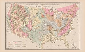
This antique Geological Map of the United States was produced by O.W. Gray as part of his "National Atlas" in 1884. Gray was involved in the production of Atlas' from ca. 1871 - 1886. We love his maps because of the wonderful hand coloring and attention to detail. This map measures 14.75 inches by 23.25 inches.
-
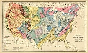
This hand colored map is from "The National Atlas, containing Elaborate Topographical Maps of the United States and the Dominion of Canada, with Plans of Cities and General Maps of the World", published by O.W. Gray in 1880. This map measures 16.5 inches by 27 inches.