Order Total (1 Item Items):
Shipping Destination:

Hydrographica, Used (49 results)
Skip to main search results
Product Type
- All Product Types
- Books (21)
- Magazines & Periodicals
- Comics
- Sheet Music
- Art, Prints & Posters (7)
- Photographs
- Maps (21)
-
Manuscripts &
Paper Collectibles
Condition
Binding
- All Bindings
- Hardcover
- Softcover (12)
Collectible Attributes
- First Edition (1)
- Signed (3)
- Dust Jacket (1)
- Seller-Supplied Images (42)
- Not Printed On Demand
Free Shipping
Seller Location
Seller Rating
-
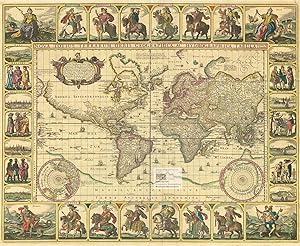
Reading the World Map: Interdisciplinary Perspectives on Pieter Van Den Keere's Map, Nova Totius Terrarum Orbis Geographica Ac Hydrographica Tabula (Amsterdam, 1608/36)
Published by Portland, ME: Osher Map Library of the University of Southern Maineand Smith Center for Cartographic Education, 2001
ISBN 10: 093956131XISBN 13: 9780939561315
Book First Edition
Paperback. Condition: Very Good. First Edition. Paperback. Pages are clean and unmarked. Covers show very minor shelving wear.; 100% Satisfaction Guaranteed! Ships same or next business day!.
More buying choices from other sellers on AbeBooks
Used offers from US$ 5.49
Also find First Edition Signed
-
Franz Ruttner zum Ged�chtnis; Separatum aus: Vol. XX. No. 2 Hydrobiologia, Acta Hydrobiologica Hydrographica et Protistologica;
Published by Den Haag, W. Junk, 1962
Seller: books4less (Versandantiquariat Petra Gros GmbH & Co. KG), Welling, Germany
Seller Rating:

Book
Heft; Condition: Gut. 7 Seiten, 1 Tafel; Der hier angebotene Sonderdruck ist informativ und kurz gehalten. Er stammt aus der Separaten-Sammlung einer wissenschaftlichen Bibliothek und tr�gt einen den Text nicht verdeckenden Stempel. Insgesamt ordentlicher Erhaltungszustand. Aufgrund der Rarit�t und des geringen Umfangs des Werkes bitten wir um Verst�ndnis, dass dieser Sonderdruck vom R�ckgaberecht ausgeschlossen ist. Sprache: Deutsch Gewicht in Gramm: 60.
-
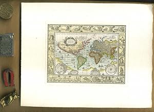
Nova Totius Terrarum Orbis Geographica Ac Hydrographica Tabula auct Guiljelmo Blaeuw. Kolerierter Nachdruck. Motivgr��e 12 x 16 cm // Blattgr��e 20 x 25 cm //. Ungerasterter Druck mit Plattenrand auf starkem B�tten. Dekorative Karte, umrahmt mit bildlichen Darstellungen der vier Elemente, sieben Weltwunder, sieben Planeten und vier Jahreszeiten.
Published by Ohne Verlag, um 1970 ???, Ohne Ort,, 1970
Art / Print / Poster
20 x 25 cm. 1 Blatt. . ISBN: Keine. Kartoniert / Soft cover. No jacket. Kartoniert / Soft cover. 1. Auflage. Sprache: de. * Versandfertig innerhalb von 20 Stunden! Meersburg ist eine Kleinstadt im baden-w�rttembergischen Bodenseekreis. Sie liegt zwischen Friedrichshafen und �berlingen. R1B2. (Rad). Jpg.
-
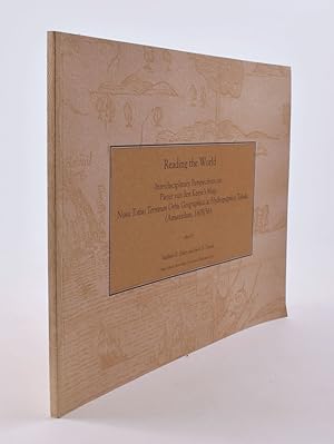
Reading the World: Interdisciplinary Perspectives on Pieter van den Keere's Map, Nova Totious Terrarum Orbis Geographica ac Hydrographica Tabula (Amsterdam, 1608/36)
Published by Portland [Maine]: Osher Map Library Associates, 2001, 2001
Seller: James Arsenault & Company, ABAA, Arrowsic, ME, U.S.A.
Association Member: ABAA ESA ILAB
Seller Rating:
Softcover. Oblong (11" x 8"), pictorial paper wrappers. 41 pp. CONDITION: Fine.
-
Quaestiones hydrographica. (= Polska Akademja umiejetnosci Rozprawy Wydzialu Filologicznego, Tom 64, Nr. 1)
Published by Krakow: Gebethner & Wolff, 1934
Book
Softcover. 219 S. OBr. Einband m. Fehlst., Kanten besto�en, Buchblock unbeschnitten, Text entsprechend sauber. Guter Zustand. --- Publisher's softcover binding. Boards damaged, uncut copy, text thus clean. Good condition. Sprache: Deutsch Gewicht in Gramm: 530.
-

Opuscolo vintage in-8� con 5 pagg, Cracovia, 1929. Saggi. Testo in lingua francese. Estratto da Bulletin de l'Academie Polonaise des Sciences et des Lettres - Cracovie 1929. Note a biro in prima pagina.
-
Nova totius terrarum orbis geogrphica ac hydrographica tabula. Farbiger Reprint einer Weltkarte der Kontinente und Meere, umgeben von zahlreichen kleinen Ansichten ber�hmter Eroberer und Feldherren sowie Stadt- und Landschaftsansichten von Rom, Amsterdam, Jerusalem, Tunis, Mexiko, Havanna, Pernambuco und San Salvador sowie Darstellungen der Europa und europ�ischer V�lker, der Afrika auf einem Krokodil mit Ansichten von Afrikanern, der Asia auf einem Kamel und asiatischen V�lkern sowie der Amerika auf einem G�rteltier mit V�lkern Mittel- und S�damerikas
Published by ohne Ort- und Jahresangabe um, 1970
Seller: historicArt Antiquariat & Kunsthandlung, Wiesbaden-Breckenheim, Germany
Seller Rating:
Map
gro�er farbiger Faksimile-Reprint der ber�hmten Weltkarte von Visscher nach Piscator auf r�ckseitig unbedrucktem Zerkall-B�tten mit Wasserzeichen, bildliche Darstellung (einschlie�lich aller Nebenkarten) ca. 31 x 38,5 cm, Blattgr��e ca. 32 x 40 cm, im Rand alte Montagereste (war unter Glas gerahmt), ansonsten sehr gut erhalten, auch als Reprint selten, muss wegen seiner Gr��e gerollt in einer stabilen Papprolle verschickt werden - gro�er und/oder schwerer Artikel mit zus�tzlichen Kosten f�r Versand und Versicherung, muss wegen �bergr��e gerollt in stabiler Papprolle verschickt werden - heavy and/or oversized item with additional costs for shipping and insurance - will be dispatched enrolled in a solid mailing tube - please ask us before you order this article 2100 gr.
-
ausgefaltet ca. 39 x 32 cm. Condition: Sehr gut. Karte Farbiger Nachdruck einer Weltkarte, Unterkante sehr leicht besto�en, Karte sonst sehr gut erhalten, ohne Jahresangabe, Sprache: Latein Ordner28 la Gewicht in Gramm: 201.
-
Hydrobiologica. Acta Hydrobiologica Hydrographica et Protistologica. New Systematical Approach to the Japanese Planktonic Rotatoria
Published by Dr. W. Junk Publishers, The Hague, 1964
Book Signed
Paper-bound. Condition: Good. Separatum XXIII 15-1-1964 Fasc. 1-2. With 30 plates and 3 text figs. 124 pp. To G. J�gersten With the author's compliments. By author.
-
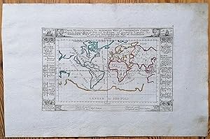
Carta Hydrographica oder Algemeine Welt und .
Published by Mappamondo
Seller: Sergio Trippini, Gavirate, Italy
Seller Rating:
Piccolo mappamondo idrografico in piano.
-
Nova Totius Terrarum Orbis Geographica ac Hydrographica Tabula. Koloriertes Faksimile einer Kupferstichkarte von Piscator, 1639. 46 x 57 cm.
Publication Date: 1639
Seller: Antiquariat Daniel Schramm e.K., Kiel, Germany
Seller Rating:

Condition: 0. Weltkarte in Mercator-Projektion mit zwei Inset-Polkarten, sowie allegorischen Darstellungen und 8 kleinen Stadtansichten im Aussenrand. Sprache: Deutsch Gewicht in Gramm: 500.
-

Condition: Used - Good.
-
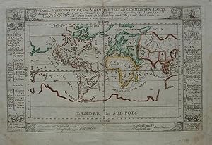
Carta Hydrographica oder Allgemeine Welt.
Published by Bodenehr, 1710
Seller: Angelika C. J. Friebe Ltd. - MapWoman, Dorking, United Kingdom
Seller Rating:
Map
No Binding. Condition: Very Good. Bodenehr Augsburg c1710.- orig. outline col. copper engr. map; 15 x 24 cm; some faint staining and stitch holes, o/w g cond.- Charming little world map from the Bodenehr family, publishers and engravers in Augsburg. It shows the world in Mercator projection, with insular CA and the trade routes. Sidepanels with description of the ?large lakes which surround the Earth? and ?the small lakes from which derive the large ones? Two small ships in the top corners.- [ref: 1615 ].
-
Nova totius terrarum orbis geographica ac hydrographica tabula. Wahre Biltn�� des Gantzen Erden Krayses mit allen seinen theilen.
Published by [Frankfurt a. M., Matth�us Merian], o. J. (um 1640)., 1640
Seller: Versandantiquariat Wolfgang Friebes, Graz, Austria
Seller Rating:
Condition: 0. Links oben ein gedruckter Text zur Entdeckung Amerikas durch Christoph Columbus, die beiden unteren Ecken mit den Darstellungen der Pole. - Die vor allem an den Seiten knapp beschnittene Karte wurde wohl in der zweiten H�lfte des 20. Jahrhunderts auf einfachem braunem Karton aufgezogen (dabei mehrere tlw. l�ngere Risse in der Darstellung geschlossen). Mittig vertikal gefaltet. Tlw. fleckig. - Erhaltung im Preis ber�cksichtigt; Fotos auf Anfrage! - Shirley 345. la Gewicht in Gramm: 350 Kupferkarte, 29 x 36 cm (Blattgr��e), in der Platte sign. M. Merian fecit".
-
Kein Einband. Condition: Gut. Original Kupferstich aus: Bodenehr: Atlas curieux oder neuer und compendieuser Atlas. Augsburg, 1720. Blattgr��e: 36 x 23 cm. Guter Zustand. Original engraving from: Bodenehr: Atlas curieux oder neuer und compendieuser Atlas. Augsburg, 1720. Sheetsize: 36 x 23 cm. Good condition.
-

Kein Einband. Condition: Gut. Original engraving from: Bodenehr: Atlas curieux oder neuer und compendieuser Atlas. Augsburg, 1720. Sheetsize: 31 x 19 cm. Condition: please see photo for spotting or staining.
-
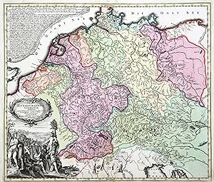
Kupferstich- Karte, b. M. Seutter, "Hydrographica Germaniae".
Seller: Antiquariat Clemens Paulusch GmbH, Berlin, Germany
Seller Rating:
Map
mit altem Fl�chenkolorit, vor 1740, 49 x 58 Sandler, S. 10 (Nr. 205). Am linken Rand 2 dek. Kartuschen, die Titelkartusche (m. zahlr. fig. Allegorien auf die Fl�sse) unten. Zeigt die Stromgebiete der gro�en Fl�sse in Deutschland. Erster Druckzustand noch ohne Privileg.
-
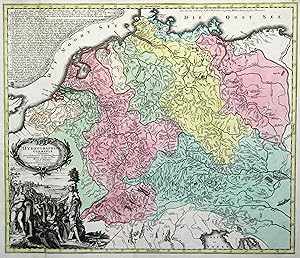
Kupferstich- Karte, b. T.C. Lotter, "Hydrographica Germaniae".
Seller: Antiquariat Clemens Paulusch GmbH, Berlin, Germany
Seller Rating:
Map
mit altem Fl�chenkolorit, nach 1762, 49 x 58 Ritter, Die Welt aus Augsburg, S. 45. Am linken Rand 2 dek. Kartuschen, die Titelkartusche (m. zahlr. fig. Allegorien auf die Fl�sse) unten. Zeigt die Stromgebiete der gro�en Fl�sse in Deutschland. Aus einer Plano-Ausgabe ohne Mittelfalz.
-
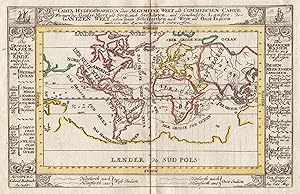
Kupferstich- Karte, b. Gab. Bodenehr, "Carta Hydrographica oder Algemeine Welt und Commercien Carte .".
Seller: Antiquariat Clemens Paulusch GmbH, Berlin, Germany
Seller Rating:
Map
mit altem Grenzkolorit, um 1710, 14,6 x 23 H�b. Weltkarte mit Erkl�rungen am linken und rechten Rand. Zeigt auch Australien.
-
mit Grenzkolorit, um 1650, 42 x 54 Krogt. Koeman's Atlantes Neerlandici, Bd. 1, Seite 567 ( Abbildung 0150:1 - lat. Ausgabe ). - Seltene, ostorientierte Seekarte, die mittig die Kanarischen Inseln zeigt. Im Nordwesten die Azoren, im Nordosten die Stra�e von Gibraltar, im S�dosten C. Verde, im S�dwesten die Kapverdischen Inseln. - Durchgehend leicht gebr�unt, Bugfalte im unteren Bereich restauriert.
-
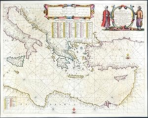
Pascaarte van`t Oostelyckste deel vande Middelandsche Zee - Tabula hydrographica de partibus Orientalioribus Maris Mediterranei
Published by Janssonius, Amsterdam, 1650
Map
Kein Einband. Condition: Sehr gut. Mediterranean Sea. "Pascaarte van`t Oostelyckste deel vande Middelandsche Zee. Tabula hydrographica de partibus Orientalioribus Maris Mediterranei". Orig. copperplate engraving published by J. Janssonius, Amsterdam, 1650. Original old colouring. With figure title cartouche, ornamental cartouche with the scale of map and two tables with names of small islands of Eastern Mediterranean. 42:54,5 cm (16 1/2 x 21 1/2 inch.). Koeman I, map 0302:1A, ed. 1:426 (1650 German) - A sea-chart of the eastern part of the Mediterranean Sea with Cyprus on the right.
-

Tabula Hydrographica, Africa Pars, Insulae Canariae, Insulae Cabo Verde, Insula Asores
Published by Amsterdam, 1650
Art / Print / Poster
Condition: ACEPTABLE. Tabula Hydrographica de Jan Janssonius (1588-1664), cart�grafo holand�s que trabaj� en �msterdam durante el siglo XVII. La carta presenta la costa occidental de �frica y parte de la de Espa�a, adem�s de las Islas de Cabo Verde, las Azores y el archipi�lago Canario. Mancha en esquina inferior derecha que no afecta a la ilustraci�n. Formato (cm): 43x54.
-
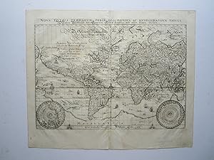
NOVA TOTIUS TERRARUM ORBIS GEOGRAPHICA AC HYDROGRAPHICA TABULA / WAHRE BILDTN�SS DES GANTZEN ERDEN KRAYSES MIT ALLEN SEINEN THEILEN'. Map of the world on Mercator s projection with two small inset polar spheres. Engraved by Merian and published by
Published by Johann Ludwig Gottfried in Frankfurt 1638, 1638
Map
26x36cm. Excellent condition. Uncoloured as originally published. Shirley 345.
-

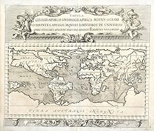
Tabula geographico-hydrographica motus oceani currentes, abyssos, montes igniuomos in universo orbe indicans
Published by Amsterdam, 1665
Seller: libreria antiquaria perini Sas di Perini, Verona, VR, Italy
Seller Rating:
Art / Print / Poster
Incisione in rame, mm 340x554. Tratta da �Mundus subterraneus� una fra le pi? note opere del grande gesuita, autore di moltissime opere, relative ad ogni campo dello scibile umano. In questa opera Kircher analizza la struttura interna della terra: egli considera che vi � un centro in continua evoluzione collegato alla crosta in numerosi punti; all�interno della terra vi sono enormi riserve d�acqua, che quando entra in contatto col fuoco scatena terremoti, uragani e distruzioni. Ottimo esemplare con traccia delle pieghe originali della tavola. Copper engraving, mm 340x554. From "Mundus Subterraneus" by Kircher. He was a celebrated Jesuit scholar and one of the first compilers of semi-scientific knowledge about the physical features of the earth. As with most of his maps, this chart shows the ocean currents, chasms and volcanoes as then recorded. Kircher suggested the earth had a central connected to the crust at many points and also contained big reservoirs of water; when water and fire interacted, volcanoes, storms and earthquakes were the result. TOOLEY: Dictionary p.357A very good example with original binding folds, side margins somewhat short Nr.cat: Cod 0789.
-
Tabula geographico-hydrographica motus oceani currentes, abyssos, montes igniuomos in universo orbe indicans�
Published by Norimberga, 1696
Seller: libreria antiquaria perini Sas di Perini, Verona, VR, Italy
Seller Rating:
Art / Print / Poster
Incisione in rame, mm 360x430. Curiosa carta del mondo che evidenzia il moto degli oceani e delle correnti, arricchita da un cartiglio barocco. Tratta da Specula Physico-Mathematico-Historica. Ottime condizioni. Zahn fu autore di numerosi studi di carattere ottico, oltre che essere un divulgatore di cultura in molteplici campi Nr.cat: Cod 0867.
-

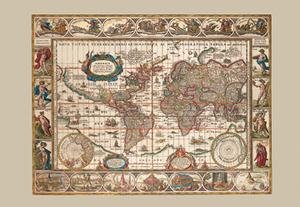
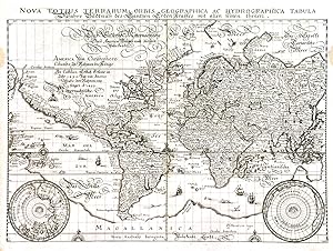
Nova Totius Terrarum Orbis Geographica ac Hydrographica Tabula
Published by Frankfurt, 1638
Seller: Bruce Marshall Rare Books, Cheltenham, United Kingdom
Seller Rating:
Map
No Binding. Condition: Very Good. Copper engraved map from Merian s Theatrum Eurpaeum, dedication to Christopher Columbus, two roundels showing north and south polar regions, ocean decorated with ships and sea monsters, central vertical fold, overall size 385 x 325mm, Frankfurt, 1638 A strong impression of Merian s edition of Blaeu s famous map of the world, also using the Mercator projection and adding German gothic script under the title and within the map. The oceans are decorated with numerous ships and sea monsters and there is a large note about Columbus and the discovery of the New World in place of modern day Canada. To the south a large mythical landmass, Magallanica, spreads across the south encompassing Antarctica and Australasia. New Guinea is attached to Magallanica but partially mapped. Tierra del Fuego is separated from the landmass but pre-dates the discovery New Zealand. North America is separated from Asia by a narrow Strait of Anian. The East Coast is still very primitive, whereas on the West Coast California is shown as a peninsula. Korea however is shown as an island, next to vague Japan and an oversized Philippines. In Europe, the prospect of an open Northeast Passage to the Pacific is still prominently shown, with the coastlines of Nova Zembla, etc., still only partially charted. Matth�us Merian, the famous Swiss publisher and engraver, began his career in Z�rich where he learned the art of copperplate engraving. Merian went on to study and work in various cities throughout France. In 1616 Merian moved to Frankfurt to work for the publisher Johann Theodor de Bry. Merian later married de Bry's daughter. He was also the father of Maria Sibylla Merian, one of the greatest natural history artists of the late 17th and early 18th centuries.
-

Tabula Geographic Hydrographica Motus Ocean, Currentes, Abysses, Montes IgniVomos in Universo Orbe Indicans. Notat Haec Fig Abyssos Montes Volcanos.
Published by Anthanasius Kircher, Amsterdam, 1665
Map
21 3/4 x 13 1/4 inches. Condition: Very good condition. this is an aesthetically pleasing compilation of aspects of physical geography. According to Tooley this is the first map to show ocean currents. additionally there are mountains in the form of volcanos. The map was part of Kircher's program of disseminating the latest information from Jesuits around the world. Kircher was prolific and scholars refer to him as the "last Renaissance man.".
-
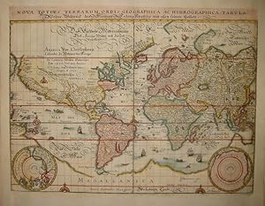
Nova Totius Terrarum Orbis Geographica ac Hydrographica Tabula Wahre Bildtn�� des Gantzen Erden Krayses mit allen seinen Theilen.
Published by anon, Frankfurt, 1646
Seller: Angelika C. J. Friebe Ltd. - MapWoman, Dorking, United Kingdom
Seller Rating:
Map
No Binding. Condition: Very Good. copper engraved map; overall 33 x 39,5 cm, plate 26 x 35,5 cm. fold as issued; some waterstains; add. printer s creases; split lower c fold not affecting image; c fold slightly warped; o/w vg cond. This very detailed map of the World is from Merian s Neuwe Archontologia Cosmica, published from 1646 onwards and based on his earlier map, first issued in 1638. According to Shirley, there are subtle differences the most important one being the absence of Merian s signature. Shirley (World) # 369.
-
Nova totius terrarum orbis geographica ac hydrographica tabula
Published by Francoforte, 1649
Seller: Libreria Ex Libris ALAI-ILAB/LILA member, Roma, Italy
Seller Rating:
Map
Incisione originale su rame (cm. 36x27,5 pi� margini) tratta dall'opera 'Archontologia cosmica, sive Imperiorum, regnorum, principatuum, rerumque publicarum omnium per totum terrarum orbem commentarii.' di Pierre d'Avity. Carta vergellata con filigrana. Raffinata coloritura all'acquarello. Margini laterali bianchi aggiunti, ma ottimo esemplare.
-

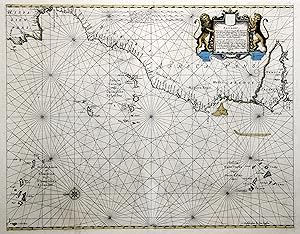
Pascaart vande Custen Van Andaluzia, Portugal, Galli�ien, Biseajen, en eengedeelt von Vranckyck, beginnen van Heysant totaende mont van de Straat van Gibraltar, alles op syn ware distantien cour�enen Polus hoogte geleyt. - Tabula Hydrographica de Oris Andalusiae, Portugalliae, Galliciae Biscajae et aliqua Galliae parte; incipiendo ab Heysantusq ad littus maritinum Gibraltar omnia cum veris suis distantiis et cursibus ad altiudinem Poli directa. Amstelodami Apud Ioannem Ian�onium
Published by J. Janssonius 1650/55, Amsterdam, 1650
Seller: Antiquariat Reinhold Berg eK Inh. R.Berg, Regensburg, Germany
Seller Rating:
Map
Other. Original antique copper engraving, hand colored in outline when published. A highly decorative sea chart of Spain with the adjacent North Africa and the 'Gulf of Biscay'. Ornated with a highly decorative engraved title cartouche with Spanish noblemen and coats of arms. Further the map is ornated with two compass roses and the pascaart is orientated North to the left. Joan Jansson's sea-atlas can be regarded as the first Dutch sea atlas in this period, which covered the entire world. Full margins as published. Minor skillfully restorations at the upper and lower centre fold, else in excellent condition. 436 by 548mm (17 by 21 inches). 436 by 548mm (17 by 21 inches).