Order Total (1 Item Items):
Shipping Destination:

Kloo (7 results)
Skip to main search results
Product Type
- All Product Types
- Books (3)
- Magazines & Periodicals
- Comics
- Sheet Music
- Art, Prints & Posters
- Photographs
- Maps (1)
-
Manuscripts &
Paper Collectibles (3)
Condition
Binding
Collectible Attributes
- First Edition
- Signed
- Dust Jacket
- Seller-Supplied Images (5)
- Not Printed On Demand
Free Shipping
Seller Location
Seller Rating
-
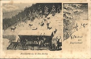
Postkarte Carte Postale 41010934 Bayrischzell Hirschfuetterung Kloo Aschau Wendelstein
Manuscript / Paper Collectible
Hirschf�tterung Kloo Aschau Alte Ansichtskarte Postkarte 1921-1965 postalisch nicht gelaufen.
-

453270,Foto Ak Kreidl Max� war beim Kloo in Geitau Junger Mann Bayrischzell Tracht
Manuscript / Paper Collectible
Zustand/M�ngel:Gute zeitgen�ssische Erhaltung.
-
Ansichtskarte Kiefersfelden, Gasthaus Joh. Kloo mit kleiner Versammlung
Manuscript / Paper Collectible
Condition: Guter Zustand. ***Ansichtskarte Kiefersfelden, Gasthaus Joh. Kloo mit kleiner Versammlung*** gelaufen, guter Zustand | Preis: 20.00 EUR | Keine MwSt.-Ausweisung, differenzbesteuert gem.�25a UStG | Versandkosten: Kostenloser Versand | Deutschland > Postleitzahl 83. > 83088 Kiefersfelden > Cafe`s / Gastst�tten / Hotels.
-

The Golden Egg (Kizzy Kloo Mysteries)
Published by KeiterBennett Publishers, 2019
ISBN 10: 0983414289ISBN 13: 9780983414285
Book
Paperback. Condition: Brand New. 82 pages. 7.81x5.06x0.19 inches. In Stock.
-

Wunder Jesu. Mitarbeiter: Helen Busslinger-Simmen, Ulrich Ruegg, Christoph Schnyder, Anton Steiner, Helen Stotzer-Kloo, Marty Voser-K�ppeli, Volker Weymann.
Published by Basel / Z�rich-K�ln: Friedrich Reinhardt / Benziger, 1978
Seller: Antiquariat Gallus / Dr. P. Adelsberger, Innsbruck, A, Austria
Seller Rating:

Opbd. (gr�ner R�cken m. schw. Schrift) 8�, 180 S., Bd. 2, (= Bibelarbeit in der Gemeinde: Themen u. Materialien, Bd. 2). Einwandfrei.
-
Jeremia Prophet in einer Zeit der Krise. Aus dem Franz�sischen von Josef Kaufmann und Helen Stotzer-Kloo.
Published by Z�rich/K�ln, Friedrich Reinhardt Verlag, 1986
ISBN 10: 3724505795ISBN 13: 9783724505792
Book
8�, Softcover/Paperback. 209 Seiten. Mit Schw.-Wei�-Abbildungen und 3 Holzschnitten von Gianni Vasari. Bibelarbeit in der Gemeinde; Band 6. Wenige leichte Bleistiftanstreichungen.Sonst gut erhalten. 23125 3724505795 Sprache: Deutsch Gewicht in Gramm: 346.
-
![Seller image for [Bird's-eye View of Amsterdam, first printed in Amsterdam in 1544, 3rd edition, 1553 or later]. Text in the cartouche in the upper right: De vermaerde koopstadt/van Amstelredam/ geconterfeyt met alle sijn Wateren/ Bruggen / Straten /Kercken /Kloo=steren/ Huysen /Toorens /Poorten ende Mueren / ende omleggende situatie /gemackt ter eeren K.M. ende oock den Eersamen Raedt der selver Stadt/ ende allen Liefhebbern der Konste/etc. Wtgegeven by Cornelis Anthonizoon Schilder/ met Octroye der K.M. onsen ghenadighsten Heere/ van't selfde niet te moghen nae-drucken noch verkoopen binnen den tijdt van ses Jaren lanck gheduerende /ende ghedateert van den Jahre duysent vijf-hondert drie-en-veertigh / op seeckere penen int selfde Octroye begrepen / op dat hem een yegelijck voor schade verhoede mach. Dese afbeeldinghe vindtmen te koop in die vermaerde koopstadt van Amstelredam achter de Nieuwe Kerck by den voorsz Cornelis Anthoniszoon, Schilder inde Schrijvende handt. CMT 1544 (The famous merchant cit for sale by Daniel Crouch Rare Books Ltd](https://pictures.abebooks.com/inventory/md/md30793857159.jpg)
[Bird's-eye View of Amsterdam, first printed in Amsterdam in 1544, 3rd edition, 1553 or later]. Text in the cartouche in the upper right: De vermaerde koopstadt/van Amstelredam/ geconterfeyt met alle sijn Wateren/ Bruggen / Straten /Kercken /Kloo=steren/ Huysen /Toorens /Poorten ende Mueren / ende omleggende situatie /gemackt ter eeren K.M. ende oock den Eersamen Raedt der selver Stadt/ ende allen Liefhebbern der Konste/etc. Wtgegeven by Cornelis Anthonizoon Schilder/ met Octroye der K.M. onsen ghenadighsten Heere/ van't selfde niet te moghen nae-drucken noch verkoopen binnen den tijdt van ses Jaren lanck gheduerende /ende ghedateert van den Jahre duysent vijf-hondert drie-en-veertigh / op seeckere penen int selfde Octroye begrepen / op dat hem een yegelijck voor schade verhoede mach. Dese afbeeldinghe vindtmen te koop in die vermaerde koopstadt van Amstelredam achter de Nieuwe Kerck by den voorsz Cornelis Anthoniszoon, Schilder inde Schrijvende handt. CMT 1544 (The famous merchant cit
Published by 1544 [1553 or later]., Amsterdam,, 1544
Seller: Daniel Crouch Rare Books Ltd, London, United Kingdom
Association Member: ABA ILAB PBFA
Seller Rating:

Map
The first printed plan of Amsterdam Large wall map, woodcut with handcut and letterpress lettering on twelve sheets, mounted on linen. Watermark (on several sheets): A yet unidentified foolscap with four pointed extensions and two shorter ones with bells, including an elongated staff with three balls. Not identified in Churchill, Laurentius, Voorn or Heawood. Condition: overall fine condition, untrimmed, and in loose sheets, some sheets a bit darkened in the corners, a few small areas of restoration to margins, perhaps pressed at some stage, apparently once framed (some dark lines in the margins do suggest this), very clean, printed on thin paper. The first printed plan of Amsterdam. Cornelis Anthonisz (1499-c1557) was a distinguished cartographer and painter, and official topographical artist to the Holy Roman Emperor. In 1538 he made a painting of Amsterdam, which he published in 1544, with his monogram and date visible under the letterpress text. It is a bird's eye view taken from an imaginary vantage point over the harbour, looking southwards. Anthonisz' depiction was the source for plans of the city for the next seventy years, while his original blocks remained in circulation for over 110 years; all printings are rare: no example of the original printing of 1544 can currently be located; of this third state, which differs from the second state by the removal of the "Daniel 5. Mene Tekel Phares" in the imprint, Karrow records only four institutional locations. This printing faithfully captures Amsterdam as it was in 1544, before the construction of the outer ring of canals, and celebrates the city's proud maritime heritage, the title supported by a large figure of Poseidon and the foreground dominated by all manner of shipping. The map shows the city of Amsterdam in the early decades of the sixteenth century, facing south, before the construction of the semi-circular ring of canals. It is bordered by the IJ, the Singel, a stretch of river Amstel, in the west and the Kloveniersburgwal and Gelderse Kade in the east. The waterway in the middle is labelled here "Den Amstel" in the South and "Damrack" in the North. The map as such does not only give an impressive view of the topography of the city and its canals and buildings, but it abounds in detail to represent a thriving commercial hub that owes its tremendous wealth to merchants and seafarers, as can be concluded from the number of ships approaching and leaving the port and canals. It is certainly not by accident that this map resembles the famous bird's-eye view of Venice, composed in 1500 by Jacopo de Barbari. The angle at which Amsterdam is shown, the waters and canals dividing the urban districts from each other, and also including an ancient Roman deity such as Neptune, the god of the waters, all imply that Cornelis was familiar with this incredible example of Renaissance printmaking. In any case, it must have suited the commissioners of the original painting, the council of Amsterdam to present their flourishing city as Venice of the North to Charles V and also to those who could afford a print of the map to express their local pride. Cornelis Anthoniszoon's map became famous and very popular soon after it was first published in 1544, so that it continued to be printed in, probably, six editions until the seventeenth century. So far, no example of the first edition is known. We only know of the first edition from an account given by Johann David Passavant in the third part of his book Le Peintre-graveur (1862), where he describes a copy from the private collection of professor Joseph Martin von Reider (1793-1862) in Bamberg/Germany. This map was already untraceable for A.E. d'Ailly in 1934, when he compiled his Catalogus van Amsterdamsche Plattegronden, and it turns out that von Reider's collection was dispersed already from 1858, when von Reider donated major parts of it to the Bavarian state. Today, neither the Staatliche Graphische Sammlung nor the Bayerisches Nationalmuseum in Munich can trace this map in their collections, although they had acquired major parts of von Reider's print collection in 1920. It is possible that it must be counted among the losses of WW2. Subsequent editions can be distinguished from earlier ones by the number of wormholes in the woodblocks, but, above all, from the modified texts in the cartouche in the upper right. Spellings were reviewed already for the second edition, and in how far the third edition differed from the second, is not yet clearly established. However, d'Ailly assumed in 1936, that "Ian Iansz" who is mentioned as printer on the fourth edition, only added his name to the text of the cartouche, after he had taken over unsold prints of the third edition from Cornelis Anthoniszoon's widow. The sixth edition was printed by Manuel Colijn, probably between 1636-1664. The date of 1544, when the map was first printed, remains prominent in all editions, probably to pay tribute to its inventor, who is mentioned in the cartouche throughout. "Cornelis is celebrated for is talents as painter, draftsman and printmaker. Yet indivisible from these practices was the Amsterdam-born artist's longtime preoccupation with mapmaking. Trained by his father in the art of engraving, Cornelis was the first printmaker to utilize that medium to chart the seas, at the time the primary conduit for trade in the Dutch Republic. In 1543 he published the Caerte van Oostland, a handbook based on both personal observations and reports from sailors that mapped the sailing route from Amsterdam to the Baltic, and which discussed the instruments and methods for surveying uncharted waters. During the time he was compiling the Caerte, Cornelis undertook the parallel project of documenting the territory contained within the Dutch borders, and in particular his native city of Amsterdam. A series of pen-and-ink studies - each a small-scale meditation on the topography of Amsterdam - culminated in 1538 in a monumental painted.