
Order Total (1 Item Items):
Shipping Destination:

La Terre (Over 10,000 results)
Skip to main search results
Product Type
- All Product Types
- Books (9,779)
- Magazines & Periodicals (2)
- Comics
- Sheet Music (7)
- Art, Prints & Posters (133)
- Photographs (12)
- Maps (111)
-
Manuscripts &
Paper Collectibles (534)
Condition
Binding
Collectible Attributes
- First Edition (149)
- Signed (30)
- Dust Jacket (119)
- Seller-Supplied Images (4,813)
- Not Printed On Demand (8,970)
Free Shipping
Seller Location
Seller Rating
-
![Seller image for Ortus Sanitatis. De herbis et plantis. De Animalibus et reptilibus. De Avibus et volatilibus. De Piscibus et natatilibus. De Lapidibus et in terre venis nascentibus. De Urinis et earum speciebus. Tabula medicinalis cum directorio generali per omnes tractatus. [Hortus Sanitatis]. for sale by Antiquariat Steffen V�lkel GmbH](https://pictures.abebooks.com/inventory/md/md31731580286.jpg)
Ortus Sanitatis. De herbis et plantis. De Animalibus et reptilibus. De Avibus et volatilibus. De Piscibus et natatilibus. De Lapidibus et in terre venis nascentibus. De Urinis et earum speciebus. Tabula medicinalis cum directorio generali per omnes tractatus. [Hortus Sanitatis].
Published by Strasbourg, Johann Pr�ss (1497)., 1497
Seller: Antiquariat Steffen V�lkel GmbH, Seubersdorf, Germany
Seller Rating:

Book First Edition
17th century leather binding [28,5 x 20 cm] with gilded element at the center of the front and back covers; with title on gilted spine: Tractat de herbis". In-folio. 360 unnumbered leaves. Text divided into two columns/page (4 columns/page in the case of the register). With over 1050 in-text woodcuts [ca. 11 x 7 cm] and 3 full-page woodcuts. With some decorative margin notes (images of human heads or hands pointing toward a certain paragraph). This very rare Incunable was first published by Jacob Meydenbach in Mainz, in the year 1491 (Hain 8940. GW 13549). Hortus Sanitatis" is a very early natural history encyclopedia, a comprehensive work which explores various species in the natural world, detailing their medicinal uses and methods of preparation. Differing from its predecessors the Latin Herbarius moguntinus" (1484) and the German Gart der Gesundheit" (1485) published by Peter Sch�ffer, which focused primarily on herbs the Hortus sanitatis" delves into animals, birds, fish, and minerals (stones) as well. Notably, it extends beyond real creatures, incorporating accounts of mythical creatures like dragons, harpies, hydras, myrmecoleons, phoenixes, and zitirons, pegasus. It summarizes all late medieval knowledge on the subject and establishes itself as the "most important natural history work of the Middle Ages" (Choulant). This encompassing work enjoyed great success during the late 15th and early 16th century, particularly thanks to its numerous illustrations, as evidenced by its numerous reissues and translations between 1491 and 1547. The author of the Hortus Sanitatis remains unidentified, despite occasional misattribution to the Frankfurt physician Johann Wonnecke von Kaub (1430 1503), the author of the above mentioned Gart der Gesundheit". This first edition printed by J. Pr�ss is recognizable by the abbreviation "(o)Mnipote[n]tis eteri[que] dei: toti[us]" (sheet aii recto, second line), while in the second edition, which is otherwise mostly identical, the text reads "( "Mnipote[n]tis eteri[que] dei: totius". Drawing from established medieval encyclopedias like the Liber pandectarum medicinae omnia medicine simplicia continens" by Matthaeus Silvaticus (14th century) and Vincent of Beauvais's Speculum naturale" (13th century), the author crafted this compilation. Additionally, the text on uroscopy at the end of the Hortus sanitatis was adapted from a widely circulated manuscript attributed to "Zacharias de Feltris" or "Bartholomew of Montagna." While an earlier Latin manuscript from 1477 contains the fundamental content of the Hortus sanitatis", initially considered a potential prototype for printing, it is now seen as an independent copy of a Latin manuscript from around the same time. Presented in a dual-column format, this work is structured into 5 sections delineating uncomplicated remedies used in healing various diseases: - "De Herbis," encompassing 530 chapters dedicated to herbs and plants - "De Animalibus", comprising 164 chapters concerning animals - terrestrial creatures - (humans are also included here, in the first chapter: "De homo"). - "De Avibus," consisting of 122 chapters discussing birds - "De Piscibus," containing 106 chapters focusing on fish and sea ( swimming") creatures - "De Lapidibus," involving 144 chapters centered on semi-precious stones, ores, and minerals. - Additionally, it includes an appendix featuring a treatise on uroscopy ( Tractatus de Urinis"). Each chapter, organized into two columns, commences with an illustrative depiction. Subsequently, the text provides a broad overview of the pertinent simple drug, followed by a section titled "operationes," listing its effects on the human body. This constitutes a significant deviation from its earlier versions it lies in the separate treatment of medicinal substances sourced from animals, stones, and metals, each given dedicated sections. For every plant, animal, and stone, their respective healing effects are compiled under specific sections titled "operations." This pioneering approach was later widely replicated across various works. The book is adorned with numerous woodcuts (approx. 1050 small ones and 3 full-page ones), some of them very interesting depictions of medicinal plants (for example, the illustration for Mandragora officinarum is a personified image of the plant, where the plant's trunk is depicted as a naked human body; the one of the plant name Narcissus" - the daffodil has some human-like figures coming out of the flowers most likely a reference to the myth of Narcissus; the illustration for the Upas tree, thought to have some narcotic properties, shows two men laying under the tree, in someting akin to the sleep of death"). Other interesting depictions include the Tree of Life, the unicorn and the mermaid. There are also woodcuts depicting scenes, sometimes of people practicing various professions or preparing butter, cheese, or bread, often highly imaginative images. Even though a lot of the woodcuts are come from the German Herbarius moguntinus, nearly one third of the herbal illustrations are new. The larger woodcuts are: the one that opens the text; the one before the chapter De Animalibus" and the one that opens the last chapter Tractatus de Urinis". Binding slightly rubbed, some pages with some staining on the outer margins of the leaves, some leaves slightly restored on the lower outer corners (no loss of text or illustrations); some pages with some minor ink lines/notes on the margins of the text. 6 leaves in the "De Animalibus" part (in the foliation with signature mark "F") most likely washed and hence slightly brighter in color. The same 6 leaves partly slightly stained. A complete, very well-preserved copy of this very important and richly illustrated incunabula. Very rare in this condition. You can see more pictures of the book on our own website. Hain-Copinger 8941. GW 13550. Goff H-487. Klebs 509.3. Schreiber 4248. Schramm XX, Abb. 1495-1608. Procto.
-
Voyage auf Levant, c`est-�-dire, dans le principaux de l`Asie Mineure, dans le isles de Chio, Rhodes, Chypre, etc. de m�me que dans le plus consid�rables villes d`Egypte, Syrie et Terre Sainte [B�nde 1 und 2}. - Voyages par la Moscovie, en Perse, et aux Indes orientales [B�nde 3-5].
Published by Rouen, Robert Machuel,, 1724
Seller: Galerie Joy Versandantiquariat UG (haftungsbeschr�nkt), Boppard, Germany
Seller Rating:

Book
5 B�nde. Portr�t-Frontispiz (Cornelis de Bruyn, Pictor), Titel, 12 nn. S., 648 S., 12 nn. S. / Titel, 565 S., 12 nn. S., 1 w. Bl. - Titel, 4 nn. S., 520 S., 12 nn. S., 1 w. Bl. / Titel, 522 S., 12 nn. S., 1 w. Bl, / Titel, 498 S., 14 nn. S., 1 w. Bl. Mit 5 gefalteten Karten und 85 (davon 12 gefaltet) Kupfertafeln. Cox I, 218 und 251. - Lipperheide Ci 50. - Tiele 208. - Reich illustrierte Gesamtausgabe von Le Bruyns (auch Le Brun, Cornelis de Bruijn, Cornelis de Bruyn) Reisen. Die B�nde 1 und 2 enthalten die Reisen im Mittelmeerraum und der Levante; die B�nde 3 bis 5 die Reisen nach Russland, Persien und Ostindien. Die Kupfer mit mehreren Ansichten auf einer Tafel zeigen St�dteansichten (darunter gro�e von Moskau, Aleppo, Jerusalem und Isphahan), Altert�mer, Trachten, Schiffe, V�gel, Pflanzen usw. Die Karten zeigen u. a. die Route von Amsterdam nach Moskau und von Moskau nach Isphahan und Gamron, das russische Reich, das Kspische Meer, die Route von Gamron nach Batavia. - Papierbedingt teils etwas gebr�unt, minimal fleckig, sonst gut erhalten; breitrandige Ausgabe auf festem Pappier und in dekorativen Einb�nden. - The indicated shipping costs refer to books weighing up to one kilogram. - B�cher, die schwerer als ein Kilogramm oder gr��er als 35 x 25 cm sind, werden als Paket verschickt und kosten innerhalb Deutschlands bis zu zwei Kilogramm 6 Euro, dar�ber hinaus 7 Euro Porto. - Sprache: Franz�sisch Gewicht in Gramm: 11550 4� (28,5 x 21 cm), Kalbslederb�nde der Zeit auf 5 B�nden, mit 2 Titelschildern und R�ckenvergoldung, Rotschnitt.
-
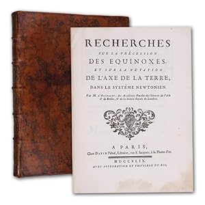
Recherches sur la pr�cession des equinoxes, et sur la nutation de l'axe de la terre, dans le syst�me newtonien.
Published by Paris David l'a�n�, 1749
Seller: Antiquariat Gerhard Gruber, Heilbronn, Germany
Seller Rating:
Book First Edition
(22 x 16 cm). XXXVIII (2) 184 S. Mit 4 gefalteten Kupfertafeln. Dekorativer Lederband der Zeit mit reicher R�ckenvergoldung. Seltene erste Ausgabe dieser bedeutenden Arbeit �ber die Pr�zession der Nachtgleichen und �ber die Nutation der Erdachse. - "The precession of the equinoxes, a problem previously attacked by Clairaut, was very difficult. D'Alembert's method was similar to Clairaut's, but he employed more terms in his integration of the equation of motion and arrived at a solution more in accord with the observed motion of the earth. He was rightly proud of his book" (DSB). - Die ersten Bl�tter im Unterrand schwach braunfleckig. Unteres Kapital leicht abgesto�en. Insgesamt sehr sch�nes und gut erhaltenes Exemplar in dekorativem zeitgen�ssichem Einband. - DSB 1, 110.
-
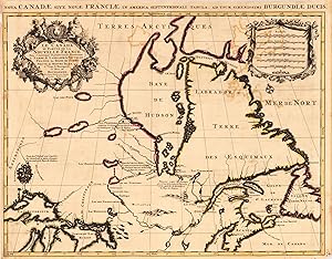
Kein Einband. Condition: Gut. Le Canada ou Partie de la Nouvelle France, Contenant la Terre de Labrador la Nouvelle France, les Isles de Terre Neuve. De Nostre Dame &c:", Mortier, Pierre Subject: Eastern Canada, Great Lakes Period: 1700 Plate Size: 78.2 x 54.6 cm., printed on thick paper, contemporary publishers colours. Very good condition, only little brownish on margins. First state of this large, striking map of the region to the north of Lake Superior and eastward. Pierre Mortier based this map on Jaillot's map of 1685, which incorporated important depictions of interior rivers and lakes from the manuscripts of Jolliet, Hennepin, and Franquelin. Lake Superior is based on the Dablon prototype, and the island-filled lake north of Lake Superior (Alemenipigon) is based on Indian reports and actually represents the lake region of Manitoba. The correct shape for Hudson Bay is based on English discoveries with Port Nelson shown in roughly the correct location. Two unnamed lakes near the source of the Nelson River provide an early depiction of Lake Winnipeg, although they are located too far to the east. A large, spurious Lac des Poux is shown west of Hudson Bay. The rivers south of Hudson Bay are also well delineated. French and English fur trading posts are identified along with brief notations. This map was published in both Suite du Neptune Francois and Atlas Nouveau.
-
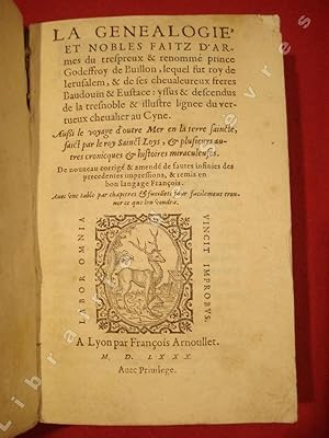
Lyon, Fran�ois Arnoullet, 1580, petit in-8 de 741-(11) pp., rel. d'�poque de parchemin ivoire � rabats (habilement restaur�e), tr�s bon ex. "Ce roman a �t� r�dig� par Pierre Desrey de Troyes, lequel, dans son prologue dat� de l'an M.CCCC. quatre vingt dix neuf, dit que ce sont des chapitres de Vincent de BEAUVAIS (Speculum historiale, lib. XXV, cap. 96 et seqq.), qu'il a translat� en fran�ais. Ce translateur y a ajout� une continuation tir�e de divers manuscrits. L'�dition de 1504 est la plus ancienne que je connaisse, mais la date du prologue en peut faire supposer une ant�rieure � 1504." (Brunet, II, 1636). Notons que dans cette chronique m�di�vale le chevalier au cygne serait l'anc�tre de Godefroy de Bouillon, qui par le biais du "Parzival" de Wolfram d'Eschenbach, deviendra Lohengrin. Pierre Desrey de Troyes (n� vers 1450 - mort apr�s 1519), �tait historien, chroniqueur et traducteur, il r�digea entre autre, un ouvrage sur la vie du roi Charles VII, et un autre sur la Conqu�te du royaume de Naples.
-
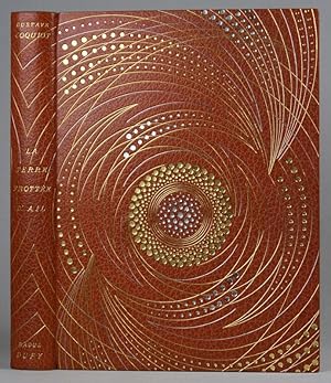
Hardcover. Condition: Sehr gut. La terre frott�e d ail par Gustave Coquiot avec 101 dessins in�dits de Raoul Dufy. Paris, Delpeuch, 1925. 264 S. 26 x 19,5 cm. - Text franz. -Nr. 83 von 100 Ex. auf V�lin d Arches. - Signierter Meistereinband von Roger Devauchelle (1915 - 1993, franz. Buchbinder) im OSchuber; Raoul Dufy (1877 - 1953, franz. Maler der klassischen Moderne (Fauvismus)); Gustave Coquiot (1865 - 1925, franz. Kunstkritiker, Schriftsteller, Sekret�r v. Rodin). Buch.
-
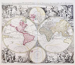
Mappe-Monde Geo-Hydrographique, ou Description Generale du Globe Terrestre et Aquatique en Deux-Plan-Hemispheres ou sont Exactement Remarqu�es en general toutes les Parties de la Terre et de l'Eau suivant les relations les plus nouvelles" - World Map Weltkarte Mappemonde California island America Australia
Published by Amsterdam ca. 1690., 1690
Seller: Antiquariat Steffen V�lkel GmbH, Seubersdorf, Germany
Seller Rating:
Map
Gro�formatige altkolorierte Kupferstich-Karte von ca. 1690. -- Blatt-Ma�e: ca. 53 x 61 cm. -- gut erhalten. || Large old colored engraved map from ca. 1690. A highly decorative world map that shows California as an island. -- in good condition. || Dies ist ein Original! - Kein Nachdruck! - Keine Kopie! -- This is an original! - No copy! - No reprint! Sprache: Franz�sisch Gewicht in Gramm: 550.
-

Bibliotheque Universelle des Voyages. Effectues par mer ou par terre dans les diverses parties du Monde, depuis les premieres decouvertes jusqu'a nos jours; contenant la description des moeurs, coutumes, gouvernemens, cultes, sciences et arts, industrie et commerce, productions naturelles et autres. 37 (von 46) B�nde der Nummern: 1, 3-6, 8-18, 20-26, 31-41, 43-45.
Published by Paris, Armand-Aubree, 1833-36., 1833
Seller: Antiquariat Welwitschia Dr. Andreas Eckl, Bochum, NRW, Germany
Seller Rating:
Goldgepr�gte Lederr�cken, marmorierte Deckel, gemusterte Vors�tze, 21 x 14 cm, je ca. 450 Seiten, Alters- und Gebrauchsspuren in unterschiedlicher Form, Einb�nde berieben, Ecken besto�en, innen teilweise stockfleckig, insgesamt von durchaus guter Erhaltung. Buch.
-
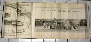
Description des trois formes du port de Brest. - Description du bagne, pour loger a terre, les galeriens ou forcats de l'Arsenla de Brest.
Published by Malassis, R. Brest., 1757
Book
Condition: Gut. 2 Teile in einem Band. 1 Blatt, 10 Seiten, 3, 1 Blatt, 3 Seiten. Mit 2 radierten gro�en Kopfvignetten, 11 (statt 12 ?; 10 gefalteten und 1 doppelblattgro�en) Kupfertafeln und 4 gestochenen Textseiten mit Schlu�vignette. -- Polak 1732 ; -- Seltene, gro�formatige Detailstudien des Hafens von Brest, seiner Geb�ude sowie seines Zuchthauses. - Teilweise etwas fleckig bzw. fingerfleckig, R�nder gebr�unt und etwas angeschmutzt, stellenweise Knickspuren, einige Restaurierungen bzw. Hinterlegungen, Tafeln teilweise anger�ndert. Seite 5/6 unten etwas beschnitten und mit Randl�suren. Die Tafeln sind 1-11 nummeriert, die letzte Tafel mit aufmontiertem klappbaren teil. Polak nennt 12 Tafeln, das Tafelverzeichnis gibt nur eine Beschreibung f�r die Tafeln 1 -11. --- With 11 large engraved folded plates and 4 engraved pages. Choquet de Lindu was a french architect and military engineer in the service of the french navy. Between 1738 and his retirement in 1784 Choquet devoted himself to the rebuilding and expansion of the port of Brest, producing "works of all kinds" : barracks, hospitals, magazines, dry docks, shipyards, prisons, sail and rope facroris, dams and docks. The fine plates show his projects for the reconstruction of the naval yards and arsenals at Brest. -- Some spotting and thumbing, marginal browning and slight soiling, some repairs and marginal restorations, partly remargined, lower margin of pp. 5/6 trimmed. Plates numbered 1-11, lacking plate 12 ?according to Plak, not mentioned in the list of plates. 19th century half-calf, rubbed, extremities worn, inner hinges cracked. deu B13-01-03F Sprache: Deutsch Gewicht in Gramm: 444 65,5 x 49 cm. Halbleder des 19. Jahrhunderts, berieben, Kanten besto�en, Innengelenke eingerissen.
-
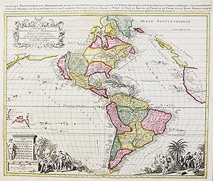
L'Am�rique septentrionale & m�ridionale divis�e en ses principales parties .Ou sont distingu�s les uns des autres les Estats suivant qu'ils appartiennent presentement Fran�ois, Castillans, Portugais, Anglois, Suedois, Danois, Hollandois &c. / Amerique Septentrionale & Meridionale divis�e en ses principales parties scavoir les Terres Arcticques, le Canada, Nouvelle France, le Mexique, Nouvelle Espagne, le Nouveau Mexique, les Isles de Terre Neuve, de Californie, Antilles, la Terre Ferme, le Perou, le Chili, le Bresil, le Paraguay, la Terre et les Isles Magellaniques ou sont distingu�s les uns des autres les Estats comme ils sont possed�s." - America Amerika Amerique California island continent Kontinent
Published by Amsterdam ca. 1700., 1700
Seller: Antiquariat Steffen V�lkel GmbH, Seubersdorf, Germany
Seller Rating:
Map
Gro�formatige altkolorierte Kupferstich-Karte von ca. 1700. -- Blatt-Ma�e: ca. 53 x 61 cm. -- gut erhalten. || Large old colored engraved map from ca. 1700. -- in good condition. || Dies ist ein Original! - Kein Nachdruck! - Keine Kopie! -- This is an original! - No copy! - No reprint! Sprache: Franz�sisch Gewicht in Gramm: 550.
-
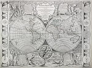
Kupferstich- Karte, v. Jean Baptist Nolin korr. v. L. Denis b. Basset, "Mappe Monde carte universelle de la Terre".
Seller: Antiquariat Clemens Paulusch GmbH, Berlin, Germany
Seller Rating:
Map
mit altem Grenzkolorit, dat. 1788, 47,5 x 64,5 Dekorative Weltkarte in 2 Hemisph�ren. Aktualisierte Version der erstmals 1755 erschienenen Karte, hier mit Einzeichnung der 1. und 2. Reise von Cook, aber nicht der 3., obwohl Hawaii schon in das Kartenbild eingetragen wurde. Oben mittig die Titelkartusche, in den Ecken jeweils Allegorien auf die 4 Kontinente in Verbindung mit jeweils einer Textkartusche. Am linken und rechten Rand eine Leiste mit je 5 Darstellungen zur Geschichte der Astronomie (nach G. Bailleul). Links knapprandig mit einem hinterlegten Einschnitt in der unteren H�lfte (dieser hinterlegt), aus einer Plano-Ausgabe ohne Mittelfalz.
-
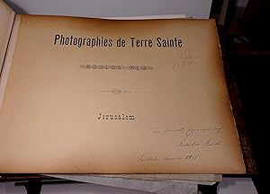
Album a photographies de la Terre Sainte arrang�es par Boulos M�o J�rusalem
Published by Jerusalem, Boulos M�o, ca. 1880, 1880
Seller: Antiquariat Thomas Mertens, Berlin, Germany
Association Member: GIAQ ILAB VDA
Seller Rating:
Photograph Signed
Hardcover. Condition: Gut bis sehr gut. Mit 48 montierten Original-Fotografien im Format 22,5 x 28 bzw. 28 x 22,5 cm. 1 Bl. Titel. Original-Halblederband mit Holzdeckeln 31,5 x 43 cm. Oblong album with 48 large albumen photographic prints (ca. 22.5 x 28 cm), signed and captioned in the negative (in French), mounted on both sides of the album's leaves. All with hand-written captions in pencil (in French) on the mount. Enth�lt, soweit identifizierbar, Fotos aus dem Studio von Adelphoi Zangaki. Im Unterrand meist in der Platte betitelt und mit Archivnummer. Enth�lt Aufnahmen von Jaffa, Bethlehem, Jericho, Jerusalem (ca. 24), Totem Meer u.a. Einband etwas berieben und besto�en. Die Montagebl�tter etwas gebr�unt und fleckig, Fotos kaum betroffen. Signatur des Verfassers.
-
Exp�riences pour d�terminer la densit� de la Terre. Traduit de l'Anglais par N. M. Chompr�.
Published by (Paris Ca ), 1815
Seller: Antiquariat Gerhard Gruber, Heilbronn, Germany
Seller Rating:
Book First Edition
(26,5 x 21 cm). SS. 263-320. Mit 2 gefalteten Kupfertafeln. Moderner Pappband im Stil der Zeit. (Aus: Journal de l'Ecole polytechnique). Erste franz�sische Ausgabe der bedeutenden, 1798 in den Philosophical Transactions erstmals erschienenen Arbeit. - "Cavendish published five papers between 1784 and 1809 relating to his astronomical interests. With one exception they were comparatively minor productions. The exception was his determination of the density of the earth (or weighing of the world) in 1798, by means of John Michell's torsion balance. The apparatus consisted of two lead balls on either end of a suspended beam; these movable balls were attracted by a pair of stationary lead balls. Cavendish calculated the force of attraction between the balls from the observed period of oscillation of the balance and deduced the density of the earth from the force. He found it to be 5.48 times that of water. Cavendish was the first to observe gravitational motions induced by comparatively minute portions of ordinary matter. The attractions that he measured were unprecedentedly small, being only 1/500,000,000 times as great as the weight of the bodies. By weighing the world he rendered the law of gravitation complete. The law was no longer a proportionality statement but a quantitatively exact one; this was the most important addition to the science of gravitation since Newton" (DSB). - Stellenweise mit leichtem Wasserrand, die Tafeln etwas st�rker, sonst gut erhalten. - DSB 3, 155; vgl. Norman 422 (engl. EA).
-
Le Canada Ou Partie De La Nouvelle France Dans l Amerique Septentrionale, Contenant la Terre de Labrador, la Nouvelle France, les Isles de Terre Neuve, de Nostre Dame, etc. a l Usage de Monseigneur Le Duc De Bourgogne. Par son tres humble. Hubert Jaillot.
Published by Hubert Jaillot., Paris, 1693
Seller: Antiquariat Reinhold Berg eK Inh. R.Berg, Regensburg, Germany
Seller Rating:
Map
Other. Copper-engraving handcolored in outline, when published. Printed around 1693 by Hubert Jaillot in Paris, published in his great atlas the Atlas Noveau. . Large and decorative map of Canada by the French cartographer Nicolaus Sanson and Hubert Jaillot. Published in the 'Atlas Noveau.', this atlas was a masterpiece in the French cartography in the 17th century. The atlas was specially designed for Louis XIV and due of the very large size of the plates, most maps were printed from two plates, it took Hubert Jaillot over 12 years to complete the 'Atlas Noveau.'. Canada is very detailled shown on the map, as well Labrador, Terra Neuf & Nouvelle France are shown in engraved territory borders. The map is rich in detail, with many cities and place names, rivers, lakes, mountains, bays, etc. In excellent condition. Minor offsetting of the old outline colors to the paper. 465 by 610mm (18� by 24 inches). 465 by 610mm (18� by 24 inches).
-
Voyage a la partie orientale de la Terre-Ferme dans l'Amerique Meridionale, fait pendant les annees 1801, 1802, 1803 et 1804. Tome I-III (in 3 B�nden).
Published by Paris Buisson, 1806
Seller: Versandantiquariat Christine Laist, Seeheim-Jugenheim, Germany
Seller Rating:
First Edition
Drei O-Ganzledereinb�nde mit Titel, Bandnummer und ornamentaler Verzierung in Golddruck auf R�cken, vergoldete Kanten-Filetten, Kleisterpapiervors�tze, Name auf Titel im 1. Band. Band I: mehrfach gefaltete "Carte de la Capitainerie Generale de Caracas", 358 Seiten; Band II: 469 Seiten; Band III: 562 Seiten mit 3 gefalteten Pl�nen (Plan de ville de Caracas, Plan du Port de la Goayre, Plan de la Rade et de la ville de Porto Cabello), 8�. Erstausgabe, First Edition. - - - �dition originale, illustr�e d'une carte et 3 plans hors texte. Fran�ois Raymond Depons (1751-1812) r�sida � Saint-Domingue apr�s avoir �tudi� le droit � Paris. Avec la r�volution de Saint-Domingue, il partit pour le Venezuela et arriva � La Guaira en mars 1801. Peu apr�s, le gouvernement fran�ais le nomma repr�sentant politique et diplomatique aupr�s de la Capitainerie g�n�rale de Caracas, o� il resta jusqu'en juillet 1804. Pendant son s�jour, il commen�a la r�daction de son ouvrage qu'il termina en France � la fin de 1805, la parution ayant lieu l'ann�e suivante. L'auteur traite en effet de diff�rents sujets comme la topographie, la l�gislation, le commerce, l'administration et l'�conomie. Le r�cit comporte aussi des d�tails sur les moeurs et coutumes des colons espagnols et des Indiens.
-
Tabula Terre Sanctae
Published by Artist: Ptolemy/ Fries Claudius/ Laurent ( Lorenz) ( - 1531 ) Lyon; issued in: Lyon; Ptolemy/ Fries Claudius/ Laurent ( Lorenz) ( 1490 - 1531 ) Lyon; Lorenz (Laurent) Fries was born in Alsace in 1490 or thereabouts describing himself on one occasion as from Colmar one of the towns of the region He studied medicine at university or rather at universities as he seems to have had a peripatetic education apparently spending time at the universities of Pavia Piacenza Montpellier and Vienna Having successfully completed his education Fries established himself as a physician at a succession of places in the Alsace region with a short spell in Switzerland before settling in Strasbourg in about 1519 By this time he had established a reputation as a, 1490
Seller: Antique Sommer& Sapunaru KG, M�nchen, Germany
Seller Rating:
Technic: Woodcut; colorit: original colored; condition: Tear on the left side perfectly restored; size (in cm): 29 x 41 cm; Map shows the entire Holy Land with title loop. Back with description and magnificent decorations of columns and ornaments. Printed by M & G Trechsel. History: The first archaeologically proven traces of an early or proto-Israelite settlement in the Mashrek region go back to the period between the 12th and 11th centuries BC. BC back. According to biblical tradition, Jerusalem was founded around 1000 BC. Conquered by David from the Jebusites and chosen as the capital of his great empire. The country subsequently became part of the Persian Empire, then the Empire of Alexander the Great, and finally the Empire of the Seleucids. The Maccabees revolt in 165 BC BC brought Israel once more state independence for about 100 years. 63 BC The time of Roman supremacy began. The Romans divided the area into two provinces: Syria in the north, Judea in the south. In the course of the Islamic expansion, the area came under Arab rule in 636. Since then, Palestine has been predominantly inhabited by Arabs. The crusaders ruled from 1099 to 1291 what they called the "Latin Kingdom of Jerusalem". This was followed by the Mamluks from 1291 to 1517 and then the Ottoman rule from 1517 to 1918. None of these authorities had planned their own administration for Palestine or viewed the area as an independent geographical unit. The region was also part of Syria for the Ottomans, probably going back to the Roman name Syria.
-
Oeuvres compl�tes. Avec des extraits de Daubenton et la classification de Cuvier. Bd. I: Mati�res g�n�rales, Th�orie de la terre. - Bd. II: �poques de la nature. - Bde. III-IV: Histoire naturelle des min�raux. - Bd. V: Histoire naturelle de l'homme. - Bd. VI: Arithm�tique morale. - Bd. VII: Histoire naturelle des animaux. - Bde. VIII-IX: Histoire naturelle des oiseaux.
Published by Paris, Adolphe Delahahays., 1857
Seller: Antiquariat Michael Solder, M�nster, NRW, Germany
Seller Rating:
Book
Condition: Gut. 9 Vols. compl. Mit gest. Portr�t, 5 (4 kolor.) gest. Karten und 105 kolor. gest. Tafeln. Diese Ausgabe nicht bei Nissen, sehr wohlerhaltenes Exemplar ohne die �blichen Br�unungen. Sprache: Franz�sisch Gewicht in Gramm: 7500 Klein-Quarto. Schwarze Original-Kalbslederb�nde.
-
Amsterdam, Henri du Sauzet, 1725, in 12 de (16)-348 pp., 32 pp. de table, joli vignette grav�e sur le titre, rel. d'�p. plein veau brun granit�, dos � nerfs, pi�ce de titre de maroquin rouge, tr�s bon ex. �d. orig. illustr�e d'une carte d�pliante du Royaume d'Alger, et d'une curieuse planche d�pliante repr�sentant Alger, son port, les bateaux alg�riens, les forts et diverses sc�nes anim�es. Laugier de Tassy exer�a pendant un an les fonctions de chancelier du consulat de France (1718-1719). Il nous livre ici, un si�cle avant Schaller, un grand nombre d'informations sur l'organisation du pouvoir, la milice turque, la course, l'esclavage, l'usage des ran�ons etc. Il d�crit �galement les moeurs locales, et donne une vision nuanc�e des relations politiques et commerciales aux travers des litiges et jugements dans lesquels il �tait consult� de par ses fontions.
-
Terre promise d`Afrique. Symphonie en noir et or avec dix-sept lithographies originales de Hans Erni.
Published by Lausanne, Andr� et Pierre Gonin,, 1966
Seller: Galerie Joy Versandantiquariat UG (haftungsbeschr�nkt), Boppard, Germany
Seller Rating:
Book
143 (7) S., 17 farb. OLithographien Hans Erni, Catalogue raisonn� des livres illustr�s, Patrick Cramer, Gen�ve 1996, S. 36. - Nr. 49 von 123 Ex. (GA 180). Gedruckt auf grand V�lin d`Arches. Druckvermerk vom K�nstler und den beiden Herausgebern sign. - The indicated shipping costs refer to books weighing up to one kilogram. - B�cher, die schwerer als ein Kilogramm oder gr��er als 35 x 25 cm sind, werden als Paket verschickt und kosten innerhalb Deutschlands bis zu zwei Kilogramm 6 Euro, dar�ber hinaus 7 Euro Porto. - Sprache: Deutsch Gewicht in Gramm: 2550 Quer-Fol., lose Bogen in lithographiertem Umschlag und HPergamentmappe, . RTitel in Rot, im Schmuckschuber (Bezug mit einer Fehlstelle).
-
Theorie de la figure de la terre, tiree des principes de l'hydrostatique. Paris, Durand 1743. Title-vignette, nomberous figs. XL, 305, [5] p. Contemporary hardbound boards with gilt back, and red cut. (rubbed, corners slightly bumped).- First edition!- Two stamps on flyleaf, stamp on title, otherwise inside a very good copy.- "In 1743 the 'Theorie de la figure de la terre' appeared. It was to some degree the theoretical epilogue to the Lapland expedition and to the series on polemics of the earth shape. It was also in this work, considered a scientific classic, that the formula named for Clairaut, expressing the earth's gravity as a function of latitude, is found." (Jean Itard in DSB III, 282).
-
L' Histoire naturelle �claircie dans une de ses parties principales, la Conchyliologie, qui traite des coquillages de mer, de rivi�re et de terre . 2 parties en 1 vol.
Published by a Paris, chez De Bure l'A�n�, 1757, 1757
Conchologie Muschel Weichtiere. 4to Gr. H 29 x B 22 cm demi-cuir / H. Leder geb. Einb. d. Zt. xxii, 394 + 84 , cviii S. avec 41 planches (komplett) Title in red and black, with woodcut vignette, .ouvrage dans lequel on trouve une nouvelle m�thode Latine & Fran�oise de les diviser: augment� de la zoomorphose, ou representation des animaux a coquilles, avec leurs explications. Nouvelle �dition. Enrichie de figures dessin�es d'apr�s nature., Par M*** des Soci�t�s royales des sciences de Londres & de Montpellier, ) un frontispice all�gorique grav� par Chedel d'apr�s Boucher (guter Zustand) 29 + 3 + 9 planches, soit 41 planches dont le frontispice.
-
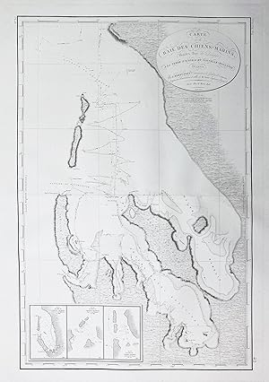
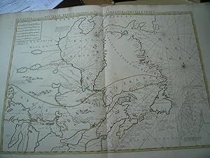
Carte de la Baie des Chiens-Marins, Shark's Bay de Dampier, a la Terre de'Endracht; Nouvelle-Hollane." - Australia Australien / Shark Bay Gascoyne
Published by Paris, 1812
Seller: Antiquariat Steffen V�lkel GmbH, Seubersdorf, Germany
Seller Rating:
Map
Gro�formatige Kupferstich-Karte aus dem 19. Jh. -- Bildmasse: ca. 75 x 50 cm. -- gut erhalten. || Large copper engraved map from the 19th century. -- in very good condition. || A detailed chart of Western Australia's coastline, including the Baie des Chiens-Marins, explored by William Dampier and Dutch ships. Crafted by Louis Claude Desaulses de Freycinet from the Baudin expedition's observations, it's part of a rare atlas. The chart, available separately from the French Hydrographic Office, showcases survey routes of various vessels. Insets display historical renderings of the bay. Notably, Captain St. Alouarn's depiction reflects French exploration in 1771. The unembellished chart emphasizes the French survey's significance in Australian exploration history, notably Dutch voyages and Dampier's contributions. Sprache: Franz�sisch Gewicht in Gramm: 35.
-
Nouvelle g�ographie universelle. La Terre et les hommes. 19 Bde.
Published by Paris Hachette et Cie -1894, 1876
M. zahlr. Taf., (teils farb.) Ktn. u. Abb. Rote goldgepr. OHldrbde. m. Goldschnitt.M. Rsign. Einbde. leicht besto�en u. berieben. Bd. 14 in abweich. Hldrbd. Bei diesem R�cken abgeplatzt. Vielf. gest. (im Text u. verso der Tafeln). Teils leicht fleckig. 1: L'Europe M�ridionale; 2: La France; 3: L'Europe Centrale; 4: L'Europe de Nord-Ouest; 5: L'Europe Scandinave et Russe; 6: L'Asie Russe; 7: L'Asie Orientale; 8: L'Inde et l'Indo-Chine; 9: L'Asie Ant�rieure; 10: L'Afrique Septentrionale (Soudan, �gyptien, �thiopie, Nubie, �gypte); 11: L'Afrique Septentrionale (Tripolitaire, Tunisie, Alg�re, Maroc, Sahara); 12: L'afrique Occidentale; 13: L'Afrique M�ridionale; 14: Oc�an et terres oc�aniques; 15: Am�rique Bor�lae; 16: Les �tats-unis; 17: Indes Occidentales; 18: Amerique du Sud (Les regions Andines); 19: Amerique du Sud (L' Amazonie et la Plata). Sprache: Franz�sisch.
-
74 S. Hln. d. 19 Jhdrs. mit Ldr.-R�ckenschild. Sabin, 75 187 Sammlung von Beschwerden der 'Leopardins'. - angebunden: DESTUTT DE TRACY (Antoine Louis Claude) Opinion de M. de Tracy, sur les affaires de Saint-Domingue. (Paris, Laillet) 1791. 23 S. Sehr fr�he Schrift von de Tracy und Meilenstein auf dem Weg zum Gesetz �ber Abschaffung der Sklaverei in den Kolonien 1794. - angebunden: (De l'Escale de V�rone, C�sar) Rapport g�n�ral sur l'affaire de Saint-Domingue , Par forme de d�nonciation en aper�u sur les abus de l'arbitraire du Gouvernement et du commerce des Isles; par un colon, membre de l'assembl�e g�n�rale: adress� � toute sa paroisse et � tous les fran�ais. (Paris, Vezard & Le Normant) 1791 100 S. (S. 93 ff.: Additions aux 'Observations sur les hommes de couleurs des colonies', die im selben Jahr erschienen) Die letzte Schrift f�r uns �ber KVK nicht nachweisbar. - Tracy durchgehend mit Abklatsch der gegen�berliegenden Seiten, L'Escale de V�rone Titel und Errata-Blatt alt gut aufgezogen (Erratablatt verso Titel) - (Santo-Domingo, Haiti, Sklaverei, Unabh�ngigkeit, Franz�sische revolution).
-
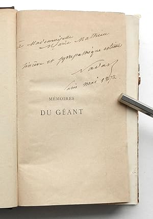
A terre & en l air. M�moires du G�ant. Avec une introduction par (Jacques) Babinet. Deuxi�me �dition
Published by Paris, E. Dentu, 1865
First Edition Signed
Tissandier, S. 30; Brockett 8972. - Der ber�hmte franz�sische Fotopionier, bekannt unter seinem Namen Nadar, beschreibt hier seine 1863 mit seinem Riesenballon Giant unternommene Luftreise vom Marsfeld in Paris bis �ber Hannover hinaus, bei der er und seine Frau bei der Bruchlandung schwer verletzt wurden. - Seconde �dition, portant un envoi de l auteur � Mademoiselle Marie Mathieu sinc�re et sympathique estime - Nadar - Paris Mai 1872 . - This second edition, made up of the same sheets as the first edition of 1864, with the addition of a frontispice-plate showing the G�ant making a dramatic landing by a railway and a folding map at the end giving the course of its flight from Paris to Rethem near Hannovre. Gaspard Felix Tournachon (pseud. Nadar, 1820-1910) abandoned his medical studies for photography and arts. Collector and protector of the French Impressionists, he was also interested in aeronautics and constructed an immense ballon Le G�ant , the largest built up till then, of 200.000 cu. ft. which carried a two storied basket containing a small printing office, photographic studio, refreshment room and lavatory. It made two ascents with first thirteen, later nine passengers, the second flight almost ending in disaster as the basket was dragged for several miles after the descent near Hannover. - Enclosed is a fine handwritten and signed letter by his son Paul Nadar (1856-1939), dated 6 Decembre 1933 with two pages (27 x 21 cm), in which the writer recalls his father s experiences as well as his friendship with Jules Verne. His friend Jules Verne, portrayed him (Nadar) under the anagram Ardan as the main character of his famous utopian novel Voyage de la Terre � la Lune (1865). - In sauberer Erhaltung, das Frontispiz im Falz ca. 1 cm in Kopie erg�nzt - A clean and fine copy, the frontispiece in the fold approx. 1 cm in copy added Doppelblattgro�es gestochenes Frontispiz, (12), 439 Seiten, 1 gefaltete lithogr. Karte Halbleinen der Zeit mit R�ckenvergoldung und goldgepr�gten R�ckenschild, 8�.
-
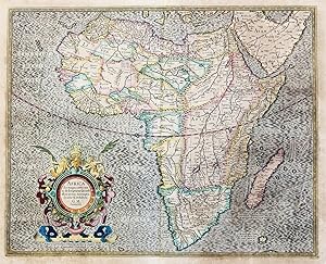
Africa, ex magna orbis terre descriptione" - Africa Afrika Afrique continent Kontinent
Published by Amsterdam, Hondius c. 1606., 1606
Seller: Antiquariat Steffen V�lkel GmbH, Seubersdorf, Germany
Seller Rating:
Map
Rare map with original color from a French edition of Mercator's Atlas Major. -- With rare original color, no modern coloring! With French text on verso. -- with some browning, partly stained on the outer margins, with a minor deposited marginal tear on the lower margin, otherwise in very good condition. || Seltene Karte mit originalem Altkolorit aus einer franz�sischen Ausgabe von Mercator's Atlas Major. -- Ma�: c. 38,5 x 47 cm. -- Kein modernes Kolorit! Mit franz�sischem Text auf der R�ckseite. -- etwas gebr�unt, im Au�enrand teils leicht fleckig, mit kleinem hinterlegten Randeinriss im unteren Au�enrand, sonst gut erhalten. || Dies ist ein Original! - Kein Nachdruck! - Keine Kopie! -- This is an original! - No copy! - No reprint! Sprache: Franz�sisch Gewicht in Gramm: 550.
-
L`Homme et la Terre [ 6 B�nde komplett].
Published by Paris, Librairie Universelle 25.10.1905 (Copyright vom 3.3.1905)., 1905
Book First Edition
Halbleder. Condition: Sehr gut. Erste Auflage. (3), IV, (2), 574 S., (2); (3), 576 S., (1); (5), 639 S., (1); (5), 652 S.,(1); (5), 575 S., (1); (5), 579 S., (1); 28 cm Zustand: wunderbare rote Halbleder Jugendstileinb�nde. Lederr�cken mit Gold und Dunkelrotpr�gung, Vorder- und R�ckendeckel mit Leinen in Lederimitat im gleichen Motiv (Mann pfl�ckt Apfel) blindgepr�gt, gering berieben, gesprenkelter Schnitt, Buntpapiervors�tze, Leseb�ndchen (bei drei B�chern noch frisch), Schnitt und im Bereich des Vorsatzpapiers leicht braunfleckig, wenig gebr�unt. Bindung fest. Band 1 mit kleinem Fleck auf dem Vorderdeckel, Band 2 hat das Blatt 1/2 doppelt, das doppelte Blatt mit umfangreicherem Text, Band 4 mit kleinem Loch im Bezug des R�ckendeckels, Band 6 hinter dem Buchblock aufgebrochen. Insgesamt wohlerhaltenes Set. --- Inhalt: Franz�sischer Text. Imprimerie de Vaugirard, Paris. -- "Jacques �lis�e Reclus (1830-1905) war ein franz�sischer Geograph und Anarchist.Extreme Genauigkeit und �berzeugende Darstellung sind die wichtigsten Eigenschaften aller Werke Reclus`; ihnen kommt ein anhaltender wissenschaftlicher und literarischer Wert zu. Er kann au�erdem als Vordenker in verschiedenen Bereichen gelten. . Kurz vor seinem Tod schloss Reclus L`Homme et la terre ab, das als Kr�nung seiner fr�heren Arbeiten zur Stellung des Menschen in seiner Umwelt angesehen werden kann. [wikipedia] --- Umfangreichst illustriert mit Abb und Karten, teils farbig PAU4-4 +++Only outside EU: Book with heavy overweight. I'll ask for more postage. +++ Sprache: Franz�sisch Gewicht in Gramm: 14000.
-
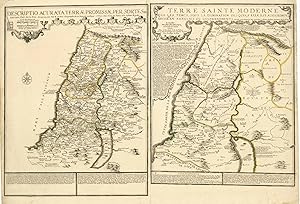
Altkolorierter Kupferstich n. Philippe De la Rue aus Atlas ou rec�eil de cartes geographiques b. Nicolas de Fer in Paris, dat. 1707, 48 x 72,5 Pastoureau, Les Atlas Francais XVI.-XVII. Si�cles, Fer II C, 88. - Zeigt zwei Karten auf einem Blatt. - Die linke Seite mit einer Karte des Heiligen Landes, die das verhei�ene Land in die zw�lf St�mme unterteilt. - Auf der rechten Seite ist eine "moderne" Karte, die die Region unter t�rkischer Herrschaft und in Provinzen unterteilt zeigt. - Die Karte wurde von Nicolas de Fer auf der Grundlage der Arbeiten von Philippe de la Rue erstellt und erstmals in seinem Atlas "Ou Recueil de Cartes Geographiques" ver�ffentlicht. - Seltene Karte!.
-
Bd. 56: Histoire generale des voyages, ou nouvelle Collection de toutes les relations de Voyages par mer et par terre, .
Published by Paris Didot, 1758
Seller: Antiquariat Clemens Paulusch GmbH, Berlin, Germany
Seller Rating:
Book
2 Bll., 507 SS. m. 9 meist mehrf. gefalt. Kst.- Tafeln , 8�, GLdr. d. Zt. m. Rvg. Bd. 56 der Pariser Oktavausgabe. Die Tafeln zeigen u.a. Nova Scotia, Plan von Quebec, St. Lorenz Strom ( 2x ), kanadische Seenkarte, Niagara, Hudson Bay u. Plan von New Orleans.
-
Bd. 55: Histoire generale des voyages, ou nouvelle Collection de toutes les relations de Voyages par mer et par terre.
Published by Paris Didot, 1758
Seller: Antiquariat Clemens Paulusch GmbH, Berlin, Germany
Seller Rating:
Book
2 Bll., 564 SS., 1 Bl. m. 8 ( 5 mehrf. gefalt.) Kst.- Tafeln , 8�, GLdr. d. Zt. auf 5 B�nden m. Rvg. Bd. 55 der Pariser Oktavausgabe. Beschreibt im Wesentlichen die Vereinigten Staaten von Nordamerika. Mit einem Stadtplan von Boston ( 16,5 x 27 cm.) und 4 mehrf. gefalt. Karten ( je ca. 20,5 x 29 cm. ),darunter " Carte de la baye de Chesapeack ", Carte de la Nouvelle Angleterre Nouvelle Yorck et Pensivanie "; "Carte de la Caroline et Georgie ." und "Carte de la Louisiane".
![Seller image for Voyage auf Levant, c`est-�-dire, dans le principaux de l`Asie Mineure, dans le isles de Chio, Rhodes, Chypre, etc. de m�me que dans le plus consid�rables villes d`Egypte, Syrie et Terre Sainte [B�nde 1 und 2}. - Voyages par la Moscovie, en Perse, et aux Indes orientales [B�nde 3-5]. for sale by Galerie Joy Versandantiquariat UG (haftungsbeschr�nkt)](https://pictures.abebooks.com/inventory/md/md31086606201.jpg)


![Seller image for L`Homme et la Terre [ 6 B�nde komplett]. for sale by Antiquariat Biebusch](https://pictures.abebooks.com/inventory/md/md31818319163.jpg)