Map Bath Maine (4 results)

Language: English
Published by War Department, Washington D. C. 1947
- First Edition
Seller: TribalBooks, Dallas, U.S.A.TribalBooks
Contact seller5-star sellerCondition: Used - Very good
US$ 20.00
US$ 5.38 shippingShips within U.S.A.Quantity: 1 available
Add to basketNo Binding. Condition: Very Good. First Edition. Color map, 17 by 21 inches, not folded as issued, 1:62,500. Edition of 1945, reprinted 1947, shipped in tube. Corner wrinkle lower right margin, Flatfile.
Language: English
Published by US Geological Survey, Washington D. C. 1937
- First Edition
Seller: TribalBooks, Dallas, U.S.A.TribalBooks
Contact seller5-star sellerCondition: Used - Very good
US$ 39.00
US$ 5.38 shippingShips within U.S.A.Quantity: 1 available
Add to basketNo Binding. Condition: Very Good. First Edition. Color map, 16.5 by 20 inches, not folded as issued, 1:62,500. Edition of 1894, reprinted 1937, shipped in tube. Flatfile.
 More images
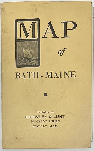
Published by Crowley & Lunt, 242 Cabot Street, Beverly, Mass 1942
- Softcover
Seller: Sandra L. Hoekstra Bookseller, Thomaston, U.S.A.Sandra L. Hoekstra Bookseller
Contact seller4-star sellerCondition: Used - Near fine
US$ 80.00
US$ 10.00 shippingShips within U.S.A.Quantity: 1 available
Add to basketWraps. Condition: Near fine. [POCKET MAP] [ADVERTISING PREMIUM]. (6" x 3 ¾") black lettering on stiff manila wrapper front and rear, small vignette of a ship in a shipyard under the letter "M"; advertisement on rear; map sheet size: 10 7/8" x 29 1/2"; 10" x 28 7/8" within the net line; light wear and hand soiling to wrapper, two… areas of glue burn to map where tipped onto the wrapper; near fine. OCLC locates this in two libraries. An advertising premium from Shaw's Book Store located at 91 Front Street, Bath, Maine. The rear ad identifies the proprietor as H. Ralph Forbes selling books, stationery, periodicals, Rust Craft greeting cards, gifts, office supplies, etc. in 1942. It also lists the three-digit "585" phone number. The fold-out street map features railroads, the Kennebec river, and identifies three towns on the opposite bank as Phippsburg, Arrowsic, and Woolwich.

Seller: Art Source International Inc., Boulder, U.S.A.Art Source International Inc.
Contact seller5-star sellerThis beautiful, original hand-colored map of the city of Bath, Winthrop Village, RichmondVillage, and Dexter Village came from the "Atlas of the State of Maine" produced by George N. Colby & Co. in 1884. Colbys atlas and the maps therein were produced in limited numbers for a short time, making city and county maps of Maine diff…icult to locate. This detailed map shows all roads (which are named), railroads, buildings and the business within, wards and or districts, schools, churches, hospitals, jails, cemeteries, parks, wharfs, ship yards, mills, court house, halls and major manufacturing plants. A fantastic map if you live in the area or know someone who does. This map measures 24 inches by 15 inches.

