
Order Total (1 Item Items):
Shipping Destination:

Mexico U Yucatan (3 results)
Skip to main search results
Product Type
- All Product Types
- Books (3)
- Magazines & Periodicals
- Comics
- Sheet Music
- Art, Prints & Posters
- Photographs
- Maps
-
Manuscripts &
Paper Collectibles
Condition
- All Conditions
- New
- Used
Binding
- All Bindings
- Hardcover
- Softcover (1)
Collectible Attributes
- First Edition
- Signed
- Dust Jacket
- Seller-Supplied Images
- Not Printed On Demand
Seller Location
Seller Rating
-

Verein-Staaten von Nord-America, Mexico, Yucatan u.a.
Published by Entw. u. gez. von Fr. v. St�lpnagel - Gestochen v. C. Metzer:, 1873
Seller: Antiquariat Gallus / Dr. P. Adelsberger, Innsbruck, A, Austria
Seller Rating:

grenzkolor. Lithographie, Bild ohne Blattrand: 31,5 x 39 cm aus: Adolf Stieler's Hand-Atlas �ber alle Theile der Erde und �ber das Weltgeb�ude. Neubearbeitet von Aug. Petermann, Herm. Berghaus u. Carl Vogel, Gotha: Justus Perthes (o.J.) [Bearbeitungszeit zw. 1871 und 1875), N� 80; guter Erhaltungszustand.
-

(Codice VN/0360) Original copper engraved map (cm 37,5x44,5 total dimensions) coming from an incomplete copy of the "HAND ATLAS �ber alle Theile der Erde und �ber das Weltgeb�ude", 1872. Hand-coloured borders. Dampmark. Mint conditions. Note: the map is sent folded up in four. Euro 20.00 All books are in stock in fine condition or described meticulously. Very safe packaging.
-
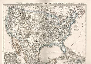
Landkarte / Map Verein-Staaten von Nord-America,Mexico, Yucatan u.A.
Published by Justus Perthes in Gotha, 1868
Softcover. Condition: Gut. 34,5 x 39,5 cm Original copper engraved map,coloured in outlines.- With insert map of With insert map of Plateau Mexico SEHR GUTES EXEMPLAR---Grenzkolorierter Stahlstich, entworfen und gezeichnet von F. von St�lpnagel. Aus Stieler's Hand-Atlas (Nr. 46). Mit Nebenkarte Plateua Mexico , 1 Seiten. nein.