
Order Total (1 Item Items):
Shipping Destination:

Mitchells New Intermediate Geography by Mitchell Samuel Augustus (6 results)
Skip to main search results
Product Type
- All Product Types
- Books (2)
- Magazines & Periodicals
- Comics
- Sheet Music
- Art, Prints & Posters
- Photographs
- Maps (4)
-
Manuscripts &
Paper Collectibles
Condition
Binding
Collectible Attributes
- First Edition
- Signed
- Dust Jacket
- Seller-Supplied Images (2)
- Not Printed On Demand (5)
Free Shipping
Seller Location
Seller Rating
-

Map of North America Engraved to Illustrate Mitchell's New Intermediate Geography
Published by J. H. Butler, Philadelphia, Pennsylvania, 1874
Seller: Xochi's Bookstore & Gallery, Truth or consequences, NM, U.S.A.
Seller Rating:

Map
Paper Back. Condition: Very Good -. No Jacket. Map of North America from Mitchell's New Intermediate Geography (believed pub.1874 --- book 3). Hand-colored map w/age-darkend paper; chips & tears on edges. includes U.S., 'British America', 'Russian America', & Mexico.
-
Map of Ohio, Michigan, Indiana, and Kentucky. Engraved to Illustrate Mitchell's New Intermediate Geography
Published by J. H. Butler, Philadelphia, Pennsylvania, 1874
Seller: Xochi's Bookstore & Gallery, Truth or consequences, NM, U.S.A.
Seller Rating:
Map
Paper Back. Condition: Very Good -. No Jacket. Map of Ohio, Michigan, Indiana, & Kentucky from Mitchell's New Intermediate Geography (believed pub.1874 --- book 3). Hand-colored map w/age-darkend paper; chips & tears on edges.
-
Map of Illinois, Wisconsin, Iowa, Missouri, and Minnesota. Engraved to Illustrate Mitchell's New Intermediate Geography
Published by J. H. Butler, Philadelphia, Pennsylvania, 1874
Seller: Xochi's Bookstore & Gallery, Truth or consequences, NM, U.S.A.
Seller Rating:
Map
Paper Back. Condition: Very Good -. No Jacket. Map of Illinois, Wisconsin, Iowa, Missouri, & Minnesota from Mitchell's New Intermediate Geography (believed pub.1874 --- book 3). Hand-colored map w/age-darkend paper; chips & tears on edges.
-
Map of the West Indies. Engraved to Illustrate Mitchell's New Intermediate Geography
Published by J. H. Butler, Philadelphia, Pennsylvania, 1874
Seller: Xochi's Bookstore & Gallery, Truth or consequences, NM, U.S.A.
Seller Rating:
Map
Paper Back. Condition: Very Good -. No Jacket. Map of the West Indies from Mitchell's New Intermediate Geography (believed pub.1874 --- book 3). Hand-colored map w/age-darkend paper; chips & tears on edges.
-
![Seller image for Geography of the state of Connecticut, designed by schools, and intended to accompany Mitchell's New intermediate geography; with a new map of the state . [LeatherBound] for sale by True World of Books](https://pictures.abebooks.com/inventory/md/md31533290169.jpg)
LeatherBound. Condition: New. Leather Binding on Spine and Corners with Golden leaf printing on spine. Bound in genuine leather with Satin ribbon page markers and Spine with raised gilt bands. A perfect gift for your loved ones. Reprinted from 1865 edition. NO changes have been made to the original text. This is NOT a retyped or an ocr'd reprint. Illustrations, Index, if any, are included in black and white. Each page is checked manually before printing. As this print on demand book is reprinted from a very old book, there could be some missing or flawed pages, but we always try to make the book as complete as possible. Fold-outs, if any, are not part of the book. If the original book was published in multiple volumes then this reprint is of only one volume, not the whole set and contains approximately 38 pages. IF YOU WISH TO ORDER PARTICULAR VOLUME OR ALL THE VOLUMES YOU CAN CONTACT US. Resized as per current standards. Sewing binding for longer life, where the book block is actually sewn (smythe sewn/section sewn) with thread before binding which results in a more durable type of binding. Language: English.
-
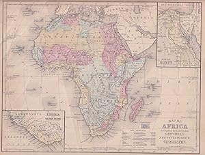
Map of Africa engraved to illustrate Mitchell's New Intermediate Geography.
Published by (E. H. Butler). (circa1869)., (Philadelphia)., 1869
Seller: Asia Bookroom ANZAAB/ILAB, Canberra, ACT, Australia
Association Member: ANZAAB ILAB
Seller Rating:

Lithographed map with original hand-colour, 21.2 x 27.6 cm, two inset maps of Liberia and Sierra Leone; and Egypt (showing the Suez Canal), text and engravings for an unrelated entry on the verso; margins dusty, top edge worn with small edge tears (one affecting the border) and marginal chip, but in good condition. Detailed map of Africa before the escalation of colonial acquisition in the 1880s.
