Order Total (1 Item Items):
Shipping Destination:

Report Upon Colorado River West, First Edition (32 results)
Skip to main search results
Product Type
- All Product Types
- Books (32)
- Magazines & Periodicals
- Comics
- Sheet Music
- Art, Prints & Posters
- Photographs
- Maps
-
Manuscripts &
Paper Collectibles
Condition
- All Conditions
- New
- Used
Binding
Collectible Attributes
- First Edition
- Signed (1)
- Dust Jacket (1)
- Seller-Supplied Images (16)
- Not Printed On Demand
Free Shipping
Seller Location
Seller Rating
-

Report upon the Colorado River of the West, explored in 1857 and 1858 by Lieutenant Joseph C. Ives, Corps of Topographical Engineers.
Published by Government Printing Office, Washington DC, 1861
First Edition
HARDCOVER. Condition: Good. 1st edition. varia paginated, quarto, embossed brown boards, numerous fold-outs, b/w ill., gilt ill. to front cover, worn edges and corners, mildly worn boards, paper title block on backstirp is detached but present, toned and foxing gutters and endpapers.
-
Report upon the Colorado River of the West Explored in 1857 and 1858 . . . Geological report by J.S. Newberry, 36th Congress, 1st Session, House of Representatives, Ex Doc. No. 90
Published by Government Printing Office, Washington, D. C., 1861
Book First Edition
Hardcover. Condition: Good. 1st Edition. 29 x 21 cm., 131, 14, 154, (12), 31 pp. Heavily illustrated with some color lithographs, two huge folding maps by Egloffstein both in fine condition except for small tears at points of attachment. Plate V opposite page 80 bound in upside down. Large book plate of some kind removed from front fixed end paper of rebinding and tiny label of Franklin Folsom (1907/07/ Rebound in green cloth with gilt printed black label on spine. (I prospected near the site of this exploration in the summer of 1955.).
-
REPORT UPON THE COLORADO RIVER OF THE WEST, EXPLORED IN 1857 AND 1858 BY LIEUTENANT JOSEPH C. IVES, CORPS OF TOPOGRAPHICAL ENGINEERS, UNDER THE DIRECTION OF THE OFFICE OF EXPLORATIONS AND SURVEYS, A.A. HUMPHREYS, CAPTAIN TOPOGRAPHICAL ENGINEERS, IN CHARGE
Published by Government Printing Office, 1861., Washington, 1861
Seller: BUCKINGHAM BOOKS, ABAA, ILAB, IOBA, GREENCASTLE, PA, U.S.A.
Association Member: ABAA ILAB IOBA RMABA
Seller Rating:

First Edition
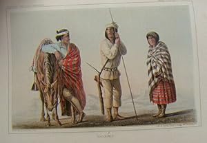
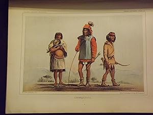
First edition. First Edition. Three-quarter Leather with Decorative Boards. [366]pp. in six sections. 2 Large folding Maps, 1 Profile, 8 folding Panoramas, 14 Views, 8 Color Plates, and 3 Paleontology Plates. House of Representatives. 36th Congress,1st Session. Ex. Doc. No. 90. "In the 1850s, the Colorado River had great potential to become an important shipping route and several companies were exploring the area. Furthermore, the Federal government needed a route for the transportation of troops and supplies to Utah, where the Mormon War was intensifying. The 1857 Army Appropriation Act provided governmental funds for the Colorado Exploring Expedition, also known as the Ives Expedition, in order to determine the navigability of the river. This topographical corps survey lasted from 1857 to 1858 and was led by Lieutenant Joseph Christmas Ives. The expedition's primary objectives were to chart the river's course and conduct a hydrographic survey that included accurately mapping the Colorado and her tributaries in the region. As a secondary and purely scientific objective, Ives was instructed to 'acquire knowledge of the surrounding country.' This entailed making a geological survey and collecting natural history and ethnological specimens. Departing December 31, 1857 from Robinson's Landing at the mouth of the Colorado River, and aboard the steamer Explorer, the expedition traveled north to Fort Yuma. By March they had reached the mouth of Black Canyon. After that, the ship and its crew began to sail back down the Colorado, eventually reaching Beale?s Crossing from where they began an overland journey to Fort Defiance via Grand Canyon. In total, 27 men made up the expeditionary force led by Ives. Other major members of the excursion were naturalist and geologist John S. Newberry, Prussian artist and the trip?s collector, Balduin Mollhausen, and topographer Baron von Egloffstein. The group was also accompanied by Indian guides, including the Mohave chief Irataba who helped lead the land portion of the expedition." A nice copy of Ives classic account of his exploration of the Colorado River. Tanning and moderate scattered foxing throughout, and off-setting to some plates, as is typical of this work. The color "Indian Portraits" bright with some light foxing. Rebound in three-quarter Leather, with decorative boards. Very Good.
-
Report upon the Colorado River of the West, Explored in 1857 and 1858; Under the direction of the Office of Explorations and Surveys, A.A. Humphreys, Captain Topographical Engineers, in charge. By order of the Secretary of War
Published by Government Printing Office, Washington, (DC), 1861
Seller: Bartleby's Books, ABAA, Chevy Chase, MD, U.S.A.
Association Member: ABAA ESA ILAB IOBA
Seller Rating:
First Edition
First edition, 36th Congress, 1st Session, Senate Ex. Doc. 4to. 131, 14, 154, 30, 6, 31, (1) pp. Illustrated, 25 plates (as called for in "List of Illustrations," plus 6 scientific plates, 8 are chromolithographs), 2 large folding maps, 8 panoramic views, profile. Howes I-92. Sabin: "The river, flowing between perpendicular walls a mile and quarter in altitude, is not the only development of this exploration that excites our interest. Lieutenant Ives was the first to give us the results of an intelligent observer of the celebrated, yet almost mythical, fortified villages of the Moquis Indians." Wagner-Camp 375. Eberstadt 120, 120. Spine rubbed, some foxing, some offset from plates, tear in one leaf repaired; a good solid copy. Original gilt-stamped decorated black cloth (rebacked, with the original spine laid down). (#5152).
-
Report Upon the Colorado River of the West, Explored in 1857 and 1858; Under the Direction of the Office of Explorations and Surveys, A. A. Humphreys, Captain Topographical Engineers in Charge. By Order of the Secretary of War
Published by Government Printing Office, Washington, 1861
Book First Edition
Hardcover. Condition: Very Good. No Jacket. 1st Edition. Joseph Christmas Ive's report of his expedition up the Colorado River, by steamboat from the Gulf of California as far as Black Canyon, then by horse and mule into the lower reaches of the Grand Canyon (called Big Canyon in this book). Beautiful drawings and engravings. The original black boards have been rebound with a new green spine. Endpapers have some wrinkles and foxing but the binding is tight and the book very readable. Wear around edges of boards but in very good shape for their age. All original bound in maps and drawings are present and in great shape. The laid in geologic maps are not present. There are small dark stains to the lower corners of appendices and the last few pages of text. General yellowing and some foxing to all pages. Bold fountain pen signature of former owner on the front pastedown. The photos are the best description. An important historical record of Grand Canyon and Colorado River, though perhaps best remembered for Ive's inaccurate valedictory: "The region is, of course, altogether valueless. Ours has been the first, and will undoubtedly be the last party of whites to visit the locality. It seems intended by nature that the Colorado River along the greater portion of its lonely and majestic way, shall be forever unvisited and undisturbed. ".
-
REPORT UPON THE COLORADO RIVER OF THE WEST.
Published by Government Printing Office, Washington, 1861
First Edition
Hardcover. Condition: Near Fine. Dust Jacket Condition: No Dust Jacket. First Edition; First Printing. 4to 11" - 13" tall; 131, 14, 154, 30, 6 pages; Senate Executive Doc. , 36th Congress, 1st Session. Complete with all plates. Missing the geologic map in part 3. The 2 large folding maps with light foxing, otherwise fine with no tears or chips. Original full leather covers with new leather spine.
-
REPORT UPON THE COLORADO RIVER OF THE WEST
Published by Government Printing Office, Washington, 1861
First Edition
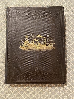
Hard Cover. Condition: Good. First Edition. Five parts and 4 Appendices bound in one volume. Pages clean and clear; some yellowing on pages facing the plates. Includes 2 large folding maps, 1 profile, 12 engraved plates including frontispiece, 7 coloured chromoplates, 8 folding panoramas and 41 woodcut illustrations. Endpapers a little yellowed, missing corner on ffep. Previous owner's small stamp on reverse of ffep. Black cloth, faded gilt titles on spine. Backstrip of spine is pulling away but intact. Lovely gilt illustration on upper cover; clear and bright. Blind stamp decoration on both covers and spine. Front hinge is loose but attached. Corners bumped and rubbed, edges rubbed. Interior is VG, binding only Fair. Overall, GOOD Size: 9 x 12.
-
GPO: Washington, DC 1861. 11.5 x 9", cloth, 131pp, two maps, eight panoramic views, 11 plates, seven color plates of Indians, ex-lib, rebound in black buckram, vg. First edition.
-
Report Upon the Colorado River of the West, Explored in 1857 and 1858 by Lieutenant Joseph C. Ives, Corps of Topographical Engineers, Under the Direction of the Office of Explorations and Surveys, A.A. Humphreys, Captain Topographical Engineers, in Charge. By Order of the Secretary of War (Senate. 36th Congress, 1st Session, Ex. Doc.)
Published by Government Printing Office, Washington, 1861
Seller: Ken Sanders Rare Books, ABAA, Salt Lake City, UT, U.S.A.
Association Member: ABAA ILAB IOBA RMABA
Seller Rating:

First Edition
Hardcover. First edition. 131+14+154+30+[7]+31 pp. (in five parts with appendices). Quarto [29 cm] Rebound in grained black buckram with gilt stamped title on the backstrip. Two maps present at front of volume (one map is detached). Both maps have six inch closed tears. Very good. Faint rubbing to corners. May require extra shipping charges due to weight. This is the first book to deal with the Colorado River specifically. The Ives report is also one of the first descriptions of the Grand Canyon (Big Canon of the Colorado), and of the area's native inhabitants. Ives expedition predated John Wesley Powell's expedition by a decade. Lacks the oft-missing laid-in geological maps, else complete with all plates, maps, wood cuts and panoramic views. Includes seven colored plates of the Indians of the southwest. ".the report is one of the most desirable books in the Colorado River field" - Francis P. Farquhar. Howes I94. Wagner/Camp 375. Wheat 947-948. Farquhar 21. Flake 4287.
-
REPORT UPON THE COLORADO RIVER OF THE WEST, Explored in 1857 and 1858; Under the direction of the Office of Explorations and Surveys, A.A. Humphreys, Captain Topographical Engineers, in charge. By order of the Secretary of War
Published by Government Printing Office, Washington, 1861
Seller: Bartleby's Books, ABAA, Chevy Chase, MD, U.S.A.
Association Member: ABAA ESA ILAB IOBA
Seller Rating:
First Edition
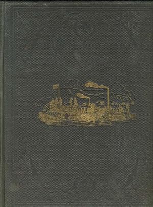
First edition, 36th Congress, 1st Session, Senate Ex. Doc. 4to. 131, 14, 154, 30, 6, 31, (1) pp. Illustrated, 25 plates (as called for in "List of Illustrations," with 8 chromolithographs and 6 scientific plates), 2 large folding maps, 8 panoramic views, profile. SABIN 35308: "The river, flowing between perpendicular walls a mile and quarter in altitude, is not the only development of this exploration that excites our interest. Lieutenant Ives was the first to give us the results of an intelligent observer of the celebrated, yet almost mythical, fortified villages of the Moquis Indians." Howes I-92. Streeter Sale 177. Wagner-Camp 375. Wheat Transmississippi 947. Farquhar 21. Flake 4287. Original brown blind stamped cloth (slight stain to upper outer corner of front cover), gilt image of a boat on front board, gilt spine title (mostly rubbed away). Internally fine with the exception of a small tear to first three leaves of the Geological Report, at gutter.
-
REPORT UPON THE COLORADO RIVER OF THE WEST, Explored in 1857 and 1858
Published by Senate Ex. Doc., 36th Congress, 1st Session, GPO, Washington, 1861, 4to., older rebind, marbled boards, leather spine and corners, gilt title and author, foldout maps., 1861
Book First Edition
Hardcover. Condition: Very Good. 1st Edition. Under the Direction of the Government Printing Office, 1861, Office of Explorations and Surveys, A.A. Humphreys, Captain Topographical Engineers, in Charge, foldout maps. Farquhar Bibliography #21. In five parts: General Report (131pp.), Hydrographic Report (14pp.), Geological Report by Newberry (154pp. plus plates), Botany by Gray, Torrey, and Englemann (30pp.) and Zoology by Baird (6pp.), plus appendixes on meteorology. Eight panoramics by Egloffstein; 12 full-page engravings, and 7 Indian plates reproduced here in color. In addition there are 41 woodcuts. Farquhar has high praise for Ives: ".one of the most desirable books in the Colorado River field, for it is the first that deals specifically with the river itself. Moreover, the illustrations are remarkable: those from M�llhausen's sketches are often admirable.two from photographs represent perhaps the first use of the camera in Arizona, certainly on the Colorado River." J. S. Newberry's contribution as expedition geologist is especially significant, for Newberry was the first to postulate a geologic theory on the origin of Grand Canyon. All plates, foldout maps (2) and Indian portraits present and in Very Good condition. Former owner's interesting bookplate signed by former owner and a small penned gift inscription by Hon. Luther Hanchett at the bottom of the first blank endpaper dated 1861. Some minor foxing and off-setting as normal in this title. Older rebind, marbled boards, leather spine and corners, title and author in gilt on spine, wear to corners and edges. Internally a very nice copy. A handsome item for your library. PRESCOTT, AZ.
-
Report Upon the Colorado River of the West, Explored in 1857 and 1858 by Lieutenant Joseph C. Ives, Corps of Topographical Engineers, Under the Direction of the Office of Explorations and Surveys, A.A. Humphreys.
Published by Government Printing Office, Washington DC, 1861
Seller: The Book Collector, Inc. ABAA, ILAB, Fort Worth, TX, U.S.A.
Association Member: ABAA ILAB IOBA
Seller Rating:
Book First Edition
Hardcover. Condition: Very Good. 1st Edition. Part I "General Report": 131 pages with the 2 large folding maps, profile of area, 12 engraved plates, including frontispiece, (one, "Interior of Moquise House", being colored), 7 colored chromolithic plates titled "Indian Portraits", 8 folding panoramas, and 41 wood cut illustrations in the text; Part II "Hydrographic Report: 14 pages; Part III " Geological Report": 154 pages with 3 plates, 3 lithographic plates, 27 wood cut illustrations in text, tables, 2 maps; Part IV "Botany": 30 pages; Part V "Zoology": 6 pages; and Appendices 32 pages. Quarto (ll 3/4" x 9") 36th Congress, 1st Session, Senate EX Document. Original gilt pictorial blind stamped cloth with gilt lettering to spine. ((Howes 194) First edition. Ives was born in New York City in 1828 and was a graduate of the United States Military Academy in 1852. As a Lieutenant from 1853 to 1854 he was appointed by the U.S. Army to the Topographical Engineers as assistant to Lt. A.W. Whipple in the Pacific Railroad survey along the 35th parallel. From 1857 to 1858 Ives commanded an expedition to explore up the Colorado River from its mouth. At Robinson's Landing he built then used the 54 foot paddlewheel steamboat Explorer to map and survey the river. His party included Smithsonian associate John Strong Newberry as geologist. He led his party up the Colorado to the lower end of the Grand Canyon, then struck out across the desert to Fort Defiance in Colorado. Ives Reported his findings in his 1861 Report upon the Colorado river of the West. The Ives expedition produced one of the important early maps of the Grand Canyon drawn by F. W. v. Egloffstein, topographer to the expedition. Ives next served as engineer and architect for the Washington National Monument from 1859 to 1860. During the American Civil War he joined the Confederate Army and served in several engineering capacities, and was finally appointed aide-de-camp to President Jefferson Davis from 1863 to 1865. After the war he settled in New York City where he died November 12, 1868 Condition: New spine and paste downs, large frontispiece maps with tears from gutter to first fold about six inches with tape repair else a very good copy.
-
Report upon the Colorado River of the West, explored in 1857 and 1858 by Lieutenant Joseph C. Ivesâ� ¦
Published by Government Printing Office, Washington, 1861
Seller: Nicholas D. Riccio Rare Books, ABAA, Florham Park, NJ, U.S.A.
Seller Rating:
First Edition
First Edition (Senate issue). 4to original cloth with gilt cover vignette, rebacked with modern cloth, leather spine label, illustrated. Some staining and wear to covers, and occasional staining and soiling within. There are some stub tears to the maps, and a few of the folding plates are ill creased. Overall in very good shape and the Indian plates are quite bright. The Ives expedition was the first real study of the Colorado, which had as its main purpose to see to what extent the river was navigable. To accomplish this task, a steamer was made in Philadelphia and shipped in parts to San Francisco, where it was back hauled to Ives in pieces in Colorado. The Streeter catalogue indicates that the â� � Ives expedition went up the Colorado some 500 miles to the limit of navigation, then continued overland along the river. The expedition disbanded at Albuquerque after transversing some 900 miles. His account of the Tonto Apaches who lived in the canyon walls is of particular interest.â� � All in all, this is an exceptional survey with some great illustrations.
-
Report upon the Colorado River of the West, Explored in 1857 and 1858
Publication Date: 1861
Seller: G.S. MacManus Co., ABAA, Bryn Mawr, PA, U.S.A.
Seller Rating:
First Edition
IVES, Joseph C. Report upon the Colorado River of the West, Explored in 1857 and 1858. Washington: Government Printing Office, 1861. 1st ed. Five Parts in one as issued. 131;14;154;30;6;31,[1, Appendix]pp. Illus., plates (some folding, some color), maps (including large folding maps). Orig. gilt-pictorial cloth. Rebacked, original spine laid down. Light scattered foxing, else very good. HOWES I-92. Wagner-Camp 375. The preferred Senate issue, which has an additional plates. In 1857 Ives was named to lead an expedition up the Colorado River in order to develop potential routes of supply in the event of a war between the national government and the Mormon settlements in Deseret (Utah).
-
REPORT UPON THE COLORADO RIVER OF THE WEST, EXPLORED IN 1857 AND 1858 BY LIEUTENANT JOSEPH C. IVES, CORPS OF TOPOGRAPHICAL ENGINEERS. UNDER THE DIRECTION OF THE OFFICE OF EXPLORATIONS AND SURVEYS, A. A. HUMPREYS, CAPTAIN TOPOGRAPHICAL ENGINEERS, IN CHARGE. BY ORDER OF THE SECRETARY OF WAR
Published by Government Printing Office, Washington, 1861
Seller: Currey, L.W. Inc. ABAA/ILAB, Elizabethtown, NY, U.S.A.
Seller Rating:
First Edition
29x21.5 cm (quarto), five parts in one volume: pp. [1-5] 6 [7-17] 18 [19] 20-23 [24-25] 26-131 [132]; [1-7] 8-14 [15-16: blank]; [1-5] 6-7 [8-9] 10-154 [155-160]; [1-5] 6-30 [31-32: blank]; [1-5] 6] [7-8: blank] [1-3] 4-5 [6] 7-31 [32], 25 inserted plates with engraved or lithographed illustrations, 8 in color, 1 inserted profile, 2 inserted maps (folded), 8 panoramic views (folded), 41 woodcut engravings in the text, plus 27 woodcut illustrations and diagrams in the geology section, original pictorial pebbled black cloth, front and spine panels stamped in gold and blind, rear panel stamped in blind. First edition, Senate issue. The first printing of the text of Ives's complete report (preceded by an 1858 preliminary report), which William Goetzmann calls "The best by far of these individual reports . It is a long, carefully written journal, consciously literary but with a maximum amount of attention to scientific observation. John Strong Newberry's geological report, which accompanied Ives's narrative, is one of the best of the government geological reports" (Wagner, Camp, Becker). "The expedition on the river was largely a waste of money, but the report is one of the most desirable books in the Colorado River field, for it is the first that deals specifically with the river itself . Ives and his staff added immensely to knowledge of the lower canyons, especially those now occupied by Hoover Dam and Lake Mead" (Farquhar). The lithographs after illustrations by Heinrich Balduin M�llhausen (1825-1905) are stunning. "In 1857 Lieutenant Joseph Christmas Ives invited M�llhausen to join his expedition to test the navigability of the Colorado River and investigate the Grand Canyon. He accepted the offer and was appointed 'artist and collector in natural history.' The exploring party assembled in San Francisco in October 1857 and then proceeded to Fort Yuma on the Colorado River. From there they traveled up the Colorado some 530 miles, first in a small steamer built specifically for the trip; and when the river became too shallow, they continued on foot to the Grand Canyon. After exploring the Grand Canyon, they left the river and headed east, reaching Fort Defiance where the expedition ended on May 23, 1858. Results of their exploration were presented by Ives in REPORT UPON THE COLORADO RIVER OF THE WEST (1861). The illustrations prepared by M�llhausen for the Ives report were some of the first views of the Grand Canyon ever published. M�llhausen left America for the last time, returning to Germany on September 1, 1858. Using his sketchbooks from the expedition he painted watercolor illustrations that he sent back to Washington for use in Ives' report" (Wikipedia). For a biographical sketch of M�llhausen, explorer, artist and novelist, "The German Cooper," see DAB. Farquhar, The Books of the Colorado River & the Grand Canyon 21. Goetzmann, pp. 379-94. Howes I92. Sabin 35308. Wagner, Camp and Becker (1982) 375. Wheat Transmississippi 4, pp. 98-101. Rebacked, wear and rubbing to extremities, some internal spotting and foxing, some foxing to plates, mostly to margins, stain to lower margin of inserted profile, frontispiece and title leaf, some wear along lower edge of one of the folded panoramic views, margins of several plates foxed, some offset on text pages facing the plates, stains and foxing to pages 128 and 129 and the margins of the plate facing page 128, overall a tight, good copy with sharp impressions of the lithographed images by M�llhausen. (#167037).
-
Report Upon the Colorado River of the West, Explored in 1857 and 1858 by Lieutenant Joseph C. Ives, Corps of Topographical Engineers, Under the Direction of the Office of Explorations and Surveys, A.A. Humphreys.etc.
Published by Washington: U. S. Government Printing Office, 1861
Book First Edition
Hardcover. Condition: Very Good. 1st Edition. All Maps, charts, chromolith plates, black and white plates, and woodcut illustrations in the text present. Aside from two neat, closed tears to the large folding plates preceding the title-page, a very handsome copy with the plates clean and the color fresh. Bound in modern smooth black cloth with the title in gilt on the spine.
-
REPORT UPON THE COLORADO RIVER OF THE WEST, EXPLORED IN 1857 AND 1858 BY LIEUTENANT JOSEPH C. IVES, CORPS OF TOPOGRAPHICAL ENGINEERS, UNDER THE DIRECTION OF THE OFFICE OF EXPLORATIONS AND SURVEYS, A.A. HUMPHREYS, CAPTAIN TOPOGRAPHICAL ENGINEERS, IN CHARGE.
Published by Government Printing Office, 1861., Washington, 1861
Seller: BUCKINGHAM BOOKS, ABAA, ILAB, IOBA, GREENCASTLE, PA, U.S.A.
Association Member: ABAA ILAB IOBA RMABA
Seller Rating:
First Edition
First edition. First edition. Five parts in one volume. Quarto. 36th Congress, 1st Session, Senate Ex Document. Original gilt pictorial, blind-stamped dark green cloth, gold stamping on spine. 2 large folding lithographic maps. One map has one, approximately 12" closed tear, professionally repaired. 8 fine folding lithographic views, 8 chromolithographic (beautiful color) plates showing dress of various Indian tribes along river and 16 lithographic plates of views (and fossils) from sketches by Baldwin Mollhausen. Probably best known as the engineer and architect of the Washington Monument, in 1857 Ives was promoted to first lieutenant and was named to lead an expedition up the Colorado River in order to develop potential routes of supply in the event of a war between the national government and the Mormon settlements in Desert (Utah). Ives's expedition included John Strong Newberry as naturalist, the Prussian Heinrich Balduin M�llhausen as artist and unofficial diarist, and F. W. Egloffstein as topographer. Ives purchased a steamboat in Philadelphia. The vessel was taken apart and shipped via the Isthmus of Panama to California and thence to the mouth of the Colorado River, where Ives and the members of his expedition rendezvoused late in 1857. Ives and his men reassembled the steamboat and christened it the Explorer. They launched the ship on 31 December 1857 and set out on their journey of reconnaissance. Ives' report is one of the first descriptions of the Grand Canyon (Big Canon of the Colorado) and of the area's native inhabitants. His expedition predated John Wesley Powell's expedition by a decade. Minimal foxing. Rubbing to corners and to head and toe of spine. Overall tight and clean. Very good.
-
REPORT UPON THE COLORADO RIVER OF THE WEST, EXPLORED IN 1857 AND 1858.
Published by Government Printing Office, Washington, 1861
Seller: Charles Agvent, est. 1987, ABAA, ILAB, Fleetwood, PA, U.S.A.
Seller Rating:
First Edition
Hardcover. First Edition. Large quarto (8-3/4" x 11-3/4") in original gilt-decorated cloth, rebacked with the original spine and a new spine label; 131, 154, 30, 32 pages. Illustrated with 12 (of 14) views, 8 color plates, 8 folding panoramas, 3 paleontology plates, 2 large folding maps, 1 profile, and many wood engravings in this, the desirable Senate issue. Farquhar 21: "one of the most desirable books in the Colorado River field, for it is the first that deals specifically with the river itself"; Flake 4287; Goetzmann, pp.379-394; Larned 412; Howes I-92; New Howes I-94 "c"; Paher 952; Sabin 35308; Wagner-Camp 375; Wheat(947), (948); Wallace, The Great Reconnaissance, p.175: "This is the most reliable and entertaining narrative of all the official reports by topographical engineers on Western explorations." Ives, commissioned to determine the navigability of the Colorado, was the first white man to explore much of its course, and this is the first government publication on the exploration of the Colorado River. Eminently readable with fine illustrations. The 8 color plates of Native Americans are outstanding. Lacks the views of Canebrake Canon and Camp Colorado Plateau, which seem never to have been bound in, as well as the two additional maps in the Geological section, which seem more often than not to not be present. Pencil signature of G. P. Sewall on the title page, likely the Cayuga, N.Y. Presbyterian minister in the 1870s. A few of the plates have a dampstain in the corner which on occasion enters the image. Very Good.
-
Report Upon the Colorado River of the West, Explored in 1857-1858
Published by Superintendent of Documents, Washington, D. C, 1861
First Edition
Decorative Cloth. Condition: Very Good+. Dust Jacket Condition: No Jacket - Issued. M�llhausen, Heinrich Baldwin (illustrator). 1st Edition. 5 parts in one volume. 2 large folding lithographic maps (clean/no tears), 8 fine folding lithographic views, 8 chromolithographic (beautiful color) plates showing dress of various Indian tribes along river and 16 lithographic plates of views (and fossils) from sketches by Baldwin Mollhausen (all clean and in excellent condition). Original decorated black cloth gilt with spine cloth missing. Overall tight and clean. Minimal foxing. Frst edition, This is the Senate and preferred issue. Probably best known as the engineer and architect of the Washington Monument (1859-1860), in 1857 Ives was "promoted to first lieutenant and was named to lead an expedition up the Colorado River in order to develop potential routes of supply in the event of a war between the national government and the Mormon settlements in Deseret (Utah). Ives's expedition included John Strong Newberry as naturalist, the Prussian Heinrich Balduin M�llhausen as artist and unofficial diarist, and F. W. Egloffstein as topographer. Ives purchased a steamboat in Philadelphia. The vessel was taken apart and shipped via the Isthmus of Panama to California and thence to the mouth of the Colorado River, where Ives and the members of his expedition rendezvoused late in 1857. Ives and his men reassembled the steamboat and christened it the Explorer. They launched the ship on 31 December 1857 and set out on their journey of reconnaissance. Overall with exception of spine covering missing an exceptional copy. Clean.
-
Report Upon the Colorado River of the West, Explored in 1857 and 1858 by Lieutenant Joseph C. Ives, Corps of Topographical Engineers, Under the Direction of the Office of Explorations and Surveys, A.A. Humphreys, Captain Topographical Engineers, in Charge [Caption title] 36th Congress 1st Session. Senate. Ex. Doc. [Unnumbered]
Published by Government Printing Office, Washington [D.C.], 1861
Seller: James Cummins Bookseller, ABAA, New York, NY, U.S.A.
Seller Rating:
First Edition Signed
First edition. First edition. Frontispiece, 1 profile, 8 fold-out panoramic views, 24 lithographs (some with tinted backgrounds, 8 have been additionally hand-colored), without 4 fold-out maps; 131; 154; 30; 6; 31, [1] pp. 1 vols. 4to (11-1/8 x 8-5/8 inches). Inscribed to Benjamin Silliman. William Goetzmann calls Lieutenant Ives's complete report, "The best by far of these individual reports.It is a long, carefully written journal, consciously literary but with a maximum amount of attention to scientific observation. John Strong Newberry's geological report, which accompanied Ives's narrative, is one of the best of the government geological reports." (Goetzmann gives a full account of the expedition in Army Exploration in the American West, pp.379-94). Includes these separately numbered parts: Geological Report. By Dr. J[ohn] S[trong] Newberry; Botany. By Professors [Asa] Gray, [John] Torrey [et al.]; Zoology. By Professor S[pencer] F[ullerton] Baird; and Appendices Inscribed by John Strong Newberry on the title page: "Prof. B. Silliman, Jr. with the kind regards of J.S. Newberry." John Strong Newberry, who was the naturalist on Ives' expedition up the Colorado River, wrote Part III of this Report, which deals with the Geology and Paleontology of the regions they explored. Ives' party were among the first white men to visit the floor of the Grand Canyon, and upon their return, it was Newberry who realized the canyon's geological significance and encouraged further exploration. It is likely that Newberry inscribed this copy to Benjamin Silliman, Jr., a famous chemist and Yale professor whose analysis of "rock oil" in Pennsylvania in 1855 introduced investors to the potential of petroleum and led to the drilling of Edwin Drake's successful oil well on his property in 1857. Silliman also took on consulting activities in the American West in the 1860's and favorably reported on petroleum deposits in southern California as well as gold and silver properties in California, Nevada, and northern Arizona. Howes I-I92; Wagner-Camp 375; Sabin 35308; Wheat, Transmississippi West 4: pp.98-101; Flake 4287; Goetzmann, pp.379-394; Larned 412; Paher, Nevada: An Annotated Bibliography, 952; Arizona 100:47 Later quarter cloth and marbled boards and endpapers. Fine copy. Bookplate of the Burndy Library (with withdrawal stamp) on the front pastedown Frontispiece, 1 profile, 8 fold-out panoramic views, 24 lithographs (some with tinted backgrounds, 8 have been additionally hand-colored), without 4 fold-out maps; 131; 154; 30; 6; 31, [1] pp. 1 vols. 4to (11-1/8 x 8-5/8 inches).
-
Report upon the Colorado River of the West. 36th Congress, 1st Session, Senate Executive Document [unnumbered].
Published by Washington: Government Printing Office, 1861., 1861
Book First Edition
Hardcover. Condition: Good. 1st Edition. 5 parts in one volume. Large 4to., (11 4/8 x 9 inches). 2 large folding lithographed maps (long tear in each, crossing the image); 8 fine folding lithographed views; 26 lithographed plates, including 8 in color (spotted throughout). Original publisher's black cloth decorated in gilt (spine detaching, extremities worn with loss). First edition, Senate and preferred issue. Probably best known as the engineer and architect of the Washington Monument (1859-1860), in 1857 in 1857 Ives was "promoted to first lieutenant and was named to lead an expedition up the Colorado River in order to develop potential routes of supply in the event of a war between the national government and the Mormon settlements in Deseret (Utah). Ives's expedition included John Strong Newberry as naturalist, the Prussian Heinrich Balduin M�llhausen as artist and unofficial diarist, and F. W. Egloffstein as topographer. Ives purchased a steamboat in Philadelphia. The vessel was taken apart and shipped via the Isthmus of Panama to California and thence to the mouth of the Colorado River, where Ives and the members of his expedition rendezvoused late in 1857. Ives and his men reassembled the steamboat and christened it the Explorer. They launched the ship on 31 December 1857 and set out on their journey of reconnaissance. They progressed northward for two months, passing through Mojave Canyon and Bill Williams's Fork, before the ship hit a rock on 5 March 1858. Following this setback, Ives divided his men into two parties, one to return with the boat, the other to return by land. Ives led the latter group, which consisted of Newberry, Egloffstein, M�llhausen, Peacock, three laborers, the Mexican packers, and twenty soldiers commanded by Lieutenant John Tipton. The groups parted company on 23 March 1858, and Ives's group soon entered the most rewarding part of their travels. On 3 April they had their first sight of what Ives called the 'Big Ca�on' (what today is called the Grand Canyon). Ives recorded his reactions, 'a splendid panorama burst suddenly into view . . . vast plateaus, towering one above the other thousands of feet in the air, the long horizontal bands broken at intervals by wide and profound abysses, and extending a hundred miles to the north, till the deep azure blue faded into a light cerulean tint that blended with the dome of the heavens.' "Ives and his men descended as far as they could that day, and the next morning (4 Apr. 1858) they stood on the floor of the Grand Canyon. Spanish explorers had sighted the Grand Canyon in 1540, and trappers probably had seen it, but Ives and his party appear to have been the first white men to visit the floor of this great natural wonder. Ives's party pushed on and visited Cataract Canyon on 12 April. On 2 May Ives divided his party again and led a small group to the villages of the Moqui. He and his men then pushed eastward and reached Fort Defiance on 23 May 1858, concluding their journey there. Their expedition had been productive in many particulars, but Ives made a strange prediction in his report, 'It seems intended by nature that the Colorado River, along the greater portion of its lone and majestic way, shall be forever unvisited and undisturbed.' The next century would prove quite the opposite to be the case" (DANB). This is the official report. Howes I-92; Sabin 35308; Wagner-Camp-Becker 375; Wheat Mapping the Transmississippi West 947, 948.
-
REPORT UPON THE COLORADO RIVER OF THE WEST, EXPLORED IN 1857 AND 1858 BY LIEUTENANT JOSEPH C. IVES, CORPS OF TOPOGRAPHICAL ENGINEERS. UNDER THE DIRECTION OF THE OFFICE OF EXPLORATIONS AND SURVEYS, A. A. HUMPREYS, CAPTAIN TOPOGRAPHICAL ENGINEERS, IN CHARGE. BY ORDER OF THE SECRETARY OF WAR
Published by Government Printing Office, Washington, 1861
Seller: Currey, L.W. Inc. ABAA/ILAB, Elizabethtown, NY, U.S.A.
Seller Rating:
First Edition
29x21.5 cm (quarto), five parts in one volume: pp. [1-5] 6 [7-17] 18 [19] 20-23 [24-25] 26-131 [132]; [1-7] 8-14 [15-16: blank]; [1-5] 6-7 [8-9] 10-154 [155-160]; [1-5] 6-30 [31-32: blank]; [1-5] 6] [7-8: blank] [1-3] 4-5 [6] 7-31 [32], 25 inserted plates with engraved or lithographed illustrations, 8 hand colored, 1 inserted profile, 2 inserted maps (folded), 8 panoramic views (folded), 41 woodcut engravings in the text, plus 27 woodcut illustrations and diagrams in the geology section, original pictorial pebbled black cloth, front and spine panels stamped in gold and blind, rear panel stamped in blind. First edition, Senate issue. The first printing of the text of Ives's complete report (preceded by an 1858 preliminary report), which William Goetzmann calls "The best by far of these individual reports . It is a long, carefully written journal, consciously literary but with a maximum amount of attention to scientific observation. John Strong Newberry's geological report, which accompanied Ives's narrative, is one of the best of the government geological reports" (Wagner, Camp, Becker). "The expedition on the river was largely a waste of money, but the report is one of the most desirable books in the Colorado River field, for it is the first that deals specifically with the river itself . Ives and his staff added immensely to knowledge of the lower canyons, especially those now occupied by Hoover Dam and Lake Mead" (Farquhar). The lithographs after illustrations by Heinrich Balduin M�llhausen (1825-1905) are stunning. "In 1857 Lieutenant Joseph Christmas Ives invited M�llhausen to join his expedition to test the navigability of the Colorado River and investigate the Grand Canyon. He accepted the offer and was appointed 'artist and collector in natural history.' The exploring party assembled in San Francisco in October 1857 and then proceeded to Fort Yuma on the Colorado River. From there they traveled up the Colorado some 530 miles, first in a small steamer built specifically for the trip; and when the river became too shallow, they continued on foot to the Grand Canyon. After exploring the Grand Canyon, they left the river and headed east, reaching Fort Defiance where the expedition ended on May 23, 1858. Results of their exploration were presented by Ives in REPORT UPON THE COLORADO RIVER OF THE WEST (1861). The illustrations prepared by M�llhausen for the Ives report were some of the first views of the Grand Canyon ever published. M�llhausen left America for the last time, returning to Germany on September 1, 1858. Using his sketchbooks from the expedition he painted watercolor illustrations that he sent back to Washington for use in Ives' report" (Wikipedia). For a biographical sketch of M�llhausen, explorer, artist and novelist, "The German Cooper," see DAB. Farquhar, The Books of the Colorado River & the Grand Canyon 21. Goetzmann, pp. 379-94. Howes I92. Sabin 35308. Wagner, Camp and Becker (1982) 375. Wheat Transmississippi 4, pp. 98-101. Bookplate of The Library of Congress affixed to the front paste-down, their small "LC" perforated stamp on title page, and by transfer Nov. 6, 1908 stamped in purple ink on the verso. Professionally rebacked, new paper label, mild foxing and offsetting, but a remarkably clean copy with plates in superior condition and minimal darkening to adjacent leaves A very nice, much better than average copy of this seminal work. (#167036).
-
Report upon the Colorado River of the West. 36th Congress, 1st Session, Senate Executive Document [unnumbered].
Published by Washington: Government Printing Office, 1861., 1861
Book First Edition
Hardcover. Condition: Very Good. 1st Edition. 5 parts in one volume. Large 4to., (11 4/8 x 9 inches). 2 large folding lithographed maps, 8 fine folding lithographed views, 8 chromolithographed plates and 16 lithographed plates of views (and fossils) from sketches by Balduin Mollhausen (spotted throughout). Original publisher's black cloth decorated in gilt (rebacked, preserving much of the original spine, front hinge starting, endpapers spotted). First edition, Senate and preferred issue. Probably best known as the engineer and architect of the Washington Monument (1859-1860), in 1857 in 1857 Ives was "promoted to first lieutenant and was named to lead an expedition up the Colorado River in order to develop potential routes of supply in the event of a war between the national government and the Mormon settlements in Deseret (Utah). Ives's expedition included John Strong Newberry as naturalist, the Prussian Heinrich Balduin M�llhausen as artist and unofficial diarist, and F. W. Egloffstein as topographer. Ives purchased a steamboat in Philadelphia. The vessel was taken apart and shipped via the Isthmus of Panama to California and thence to the mouth of the Colorado River, where Ives and the members of his expedition rendezvoused late in 1857. Ives and his men reassembled the steamboat and christened it the Explorer. They launched the ship on 31 December 1857 and set out on their journey of reconnaissance. They progressed northward for two months, passing through Mojave Canyon and Bill Williams's Fork, before the ship hit a rock on 5 March 1858. Following this setback, Ives divided his men into two parties, one to return with the boat, the other to return by land. Ives led the latter group, which consisted of Newberry, Egloffstein, M�llhausen, Peacock, three laborers, the Mexican packers, and twenty soldiers commanded by Lieutenant John Tipton. The groups parted company on 23 March 1858, and Ives's group soon entered the most rewarding part of their travels. On 3 April they had their first sight of what Ives called the 'Big Ca�on' (what today is called the Grand Canyon). Ives recorded his reactions, 'a splendid panorama burst suddenly into view . . . vast plateaus, towering one above the other thousands of feet in the air, the long horizontal bands broken at intervals by wide and profound abysses, and extending a hundred miles to the north, till the deep azure blue faded into a light cerulean tint that blended with the dome of the heavens.' "Ives and his men descended as far as they could that day, and the next morning (4 Apr. 1858) they stood on the floor of the Grand Canyon. Spanish explorers had sighted the Grand Canyon in 1540, and trappers probably had seen it, but Ives and his party appear to have been the first white men to visit the floor of this great natural wonder. Ives's party pushed on and visited Cataract Canyon on 12 April. On 2 May Ives divided his party again and led a small group to the villages of the Moqui. He and his men then pushed eastward and reached Fort Defiance on 23 May 1858, concluding their journey there. Their expedition had been productive in many particulars, but Ives made a strange prediction in his report, 'It seems intended by nature that the Colorado River, along the greater portion of its lone and majestic way, shall be forever unvisited and undisturbed.' The next century would prove quite the opposite to be the case" (DANB). This is the official report. Howes I-92; Sabin 35308; Wagner-Camp-Becker 375; Wheat Mapping the Transmississippi West 947, 948.
-
Report Upon the Colorado River of the West by Joseph C. Ives, Antique Volume with Folding Maps, 1861
Published by Government Printing Office, 1861
Book First Edition
Hardcover. Condition: Very Good. 1st Edition. Ives, Joseph C. Report Upon the Colorado River of the West. Washington: Government Printing Office, 1861. First edition. This report on Ives explorations includes the Lieutenant s observations as well as those of his accompanying scientists, fifteen full-page engravings, two large folding maps, eight large folding panoramic views, seven chromolithographic portraits of Native Americans, three paleontology plates, and many in-text wood engravings. The highly illustrated book was the first published account in the United States detailing the vast Colorado River, The Grand Canyon, and the scientific specimens found there. Overall very good condition. The internal pages show slight toning from age, but no other notable damage. The book has been rebound in beautiful three-quarter red leather with marbled paper. Housed in a custom-built archival slipcase, the book will remain protected. Dimensions: 12" H x 9 1/2" W x 2" D (with slipcase).
-
Report upon the Colorado River of the West, Explored in 1857 and 1858 by Lieutenant Joseph C. Ives, Corps of Topographical Engineers, under the Direction of the Office of Explorations and Surveys, A.A. Humphreys, Captain Topographical Engineers, in charge.
Published by Government Printing Office, 1861
Book First Edition
Hardcover. Condition: Good. 1st Edition. Washington: Government Printing Office, 1861. First edition. 5 parts in one volume. Large Quarto (11 1/2" x 8 7/8", 290mm x 222mm). With 2 large folding lithographic maps, 8 folding lithographic views, 8 chromolithographic plates and 16 lithographic plates of views (and fossils) from sketches by Balduin Mollhausen. Original black cloth gilt. Rebacked, preserving the original spine, corners renewed, worn at extremities. Gilt worn off part of boat vignette on cover. Chips and tears to the edges. Frontispiece detached. Both folding maps torn, and Camp Colorado Plateau VII map torn. Water staining and offsetting throughout. Joseph Christmas Ives (1828-1868) was best known as the engineer and architect of the Washington Monument (1859-1860). In 1857 Ives was promoted to first lieutenant and named to lead an expedition up the Colorado River in order to develop potential routes of supply in the event of a war between the national government and the Mormon settlements in Deseret (Utah). Ives's expedition included John Strong Newberry as naturalist, the Prussian Heinrich Balduin M�llhausen as artist and unofficial diarist, and F. W. Egloffstein as topographer. Ives purchased a steamboat in Philadelphia. The vessel was taken apart and shipped via the Isthmus of Panama to California and then to the mouth of the Colorado River, where Ives and the members of his expedition met late in 1857. Ives and his men reassembled the steamboat and christened it the Explorer. They launched the ship on 31 December 1857 and set out on their journey of reconnaissance. They progressed northward for two months, passing through Mojave Canyon and Bill Williams's Fork, before the ship hit a rock on 5 March 1858. Following this setback, Ives divided his men into two parties, one to return with the boat, the other to return by land. Ives led the latter group, which consisted of Newberry, Egloffstein, M�llhausen, Peacock, three laborers, the Mexican packers, and twenty soldiers commanded by Lieutenant John Tipton. The groups parted company on 23 March 1858, and Ives's group soon entered the most rewarding part of their travels. On 3 April they had their first sight of what Ives called the "Big C�non" (the Grand Canyon). Ives recorded his reactions, "a splendid panorama burst suddenly into view . . . vast plateaus, towering one above the other thousands of feet in the air, the long horizontal bands broken at intervals by wide and profound abysses, and extending a hundred miles to the north, till the deep azure blue faded into a light cerulean tint that blended with the dome of the heavens." Ives and his men descended as far as they could that day, and the next morning (4 Apr. 1858) they stood on the floor of the Grand Canyon. Spanish explorers had sighted the Grand Canyon in 1540, and trappers probably had seen it, but Ives and his party appear to have been the first white men to visit the floor of this great natural wonder. Ives's party pushed on and visited Cataract Canyon on 12 April. On 2 May Ives divided his party again and led a small group to the villages of the Moqui. He and his men then pushed eastward and reached Fort Defiance on 23 May 1858, concluding their journey there.
-
Report upon the Colorado River of the West. . .by order of the Secretary of War
Published by Washington: Government Printing Office, 1861
Book First Edition
Hardcover. Condition: Near Fine. 1st Edition. FIRST EDITION. Large 4to,modern smooth black cloth lettered in gilt on the spine. All 5 parts bound in one volume. Tall copy (11-3/8)inches). 2 large folding lithographed maps,one of which, preceding the frontispiece with a closed tear at the gutter. 8 fine folding lithographed views, 8 chromolithographic plates with 16 additional lithographed plates of views, and fossils from drawings by Mollhausen. A bright fresh copy with no foxing or offset;remnants of an institutional label on the front paste-down. Postage will be extra,depending on address; a heavy volume.
-
Report upon the Colorado River of the West.
Published by Washington: Government Printing Office, 1861
Book First Edition
Hardcover. Condition: Very Good. 1st Edition. FIRST EDITION. Large 4to,modern smooth black cloth lettered in gilt on the spine. All 5 parts bound in one volume. Tall copy (11-3/8)inches). 2 large folding lithographed maps,one of which, preceding the frontispiece with a closed tear at the gutter. 8 fine folding lithographed views, 8 chromolithographic plates with 16 additional lithographed plates of views, and fossils from drawings by Mollhausen. A bright fresh copy with no foxing or offset;remnants of an institutional label on the front paste-down. Postage will be extra,depending on address; a heavy volume.
-
Report upon the Colorado River of the West. 36th Congress, 1st Session. Senate Executive Document [unnumbered].
Published by Washington, D.C.: Government Printing Office, 1861., 1861
Book First Edition
Hardcover. Condition: Very Good. 1st Edition. 5 parts in one volume. Large 4to., (11 2/8 x 8 4/8 inches). 2 large folding lithographic maps (laid down on linen), 8 fine folding lithographic views (laid down on linen), 8 chromolithographic plates and 16 lithographic plates of views (and fossils) from sketches by Baldwin Mollhausen (some minor spotting). Contemporary half black morocco (extremities scuffed). First edition, Senate and preferred issue. Probably best known as the engineer and architect of the Washington Monument (1859-1860), in 1857 in 1857 Ives was "promoted to first lieutenant and was named to lead an expedition up the Colorado River in order to develop potential routes of supply in the event of a war between the national government and the Mormon settlements in Deseret (Utah). Ives's expedition included John Strong Newberry as naturalist, the Prussian Heinrich Balduin M�llhausen as artist and unofficial diarist, and F. W. Egloffstein as topographer. Ives purchased a steamboat in Philadelphia. The vessel was taken apart and shipped via the Isthmus of Panama to California and thence to the mouth of the Colorado River, where Ives and the members of his expedition rendezvoused late in 1857. Ives and his men reassembled the steamboat and christened it the Explorer. They launched the ship on 31 December 1857 and set out on their journey of reconnaissance. They progressed northward for two months, passing through Mojave Canyon and Bill Williams's Fork, before the ship hit a rock on 5 March 1858. Following this setback, Ives divided his men into two parties, one to return with the boat, the other to return by land. Ives led the latter group, which consisted of Newberry, Egloffstein, M�llhausen, Peacock, three laborers, the Mexican packers, and twenty soldiers commanded by Lieutenant John Tipton. The groups parted company on 23 March 1858, and Ives's group soon entered the most rewarding part of their travels. On 3 April they had their first sight of what Ives called the "Big C�non" (what today is called the Grand Canyon). Ives recorded his reactions, "a splendid panorama burst suddenly into view . . . vast plateaus, towering one above the other thousands of feet in the air, the long horizontal bands broken at intervals by wide and profound abysses, and extending a hundred miles to the north, till the deep azure blue faded into a light cerulean tint that blended with the dome of the heavens." Ives and his men descended as far as they could that day, and the next morning (4 Apr. 1858) they stood on the floor of the Grand Canyon. Spanish explorers had sighted the Grand Canyon in 1540, and trappers probably had seen it, but Ives and his party appear to have been the first white men to visit the floor of this great natural wonder. Ives's party pushed on and visited Cataract Canyon on 12 April. On 2 May Ives divided his party again and led a small group to the villages of the Moqui. He and his men then pushed eastward and reached Fort Defiance on 23 May 1858, concluding their journey there. Their expedition had been productive in many particulars, but Ives made a strange prediction in his report, "It seems intended by nature that the Colorado River, along the greater portion of its lone and majestic way, shall be forever unvisited and undisturbed." The next century would prove quite the opposite to be the case" (DANB). This is the official report. Howes I-92; Sabin 35308; Wagner-Camp-Becker 375; Wheat Mapping the Transmississippi West 947, 948. Catalogued by Kate Hunter.
-
Report upon the Colorado River of the West, Explored in 1857 and 1858 by Lieutenant Joseph C. Ives, Corps of Topographical Engineers, under the Direction of the Office of Explorations and Surveys, A.A. Humphreys, Captain Topographical Engineers, in charge.
Published by Government Printing Office, 1861
Book First Edition
Hardcover. Condition: Very Good. 1st Edition. Washington: Government Printing Office, 1861. First edition, Senate and prefered issue. 5 parts in one volume. Large Quarto., (11 3/8"x 9", 290mm x 230mm). With 34 illustrations. 2 large folding lithographed maps with original hand-colour in part and in full respectively, 8 folding lithographed views, 8 chromolithographed plates and 16 lithographed plates of views (and fossils) from sketches by Balduin Mollhausen. Original black cloth decorated in gilt. Spine strip nearly detached. Extremities worn, cover damaged. Light foxing. Modern ownership inscription of Dudley W. Stoddard on the recto of the initial binder's blank. Probably best known as the engineer and architect of the Washington Monument (1859-1860), Ives was promoted in 1857 to first lieutenant and was named to lead an expedition up the Colorado River in order to develop potential routes of supply in the event of a war between the national government and the Mormon settlements in Deseret (Utah). Ives's expedition included John Strong Newberry as naturalist, the Prussian Heinrich Balduin Mollhausen as artist and unofficial diarist, and F. W. Egloffstein as topographer. Ives purchased a steamboat in Philadelphia. The vessel was taken apart and shipped via the Isthmus of Panama to California and then to the mouth of the Colorado River, where Ives and the members of his expedition rendezvoused late in 1857. Ives and his men reassembled the steamboat and christened it the Explorer. They launched the ship on 31 December 1857 and set out on their journey of reconnaissance. They progressed northward for two months, passing through Mojave Canyon and Bill Williams's Fork, before the ship hit a rock on 5 March 1858. Following this setback, Ives divided his men into two parties, one to return with the boat, the other to return by land. Ives led the latter group, which consisted of Newberry, Egloffstein, Mollhausen, Peacock, three laborers, the Mexican packers, and twenty soldiers commanded by Lieutenant John Tipton. The groups parted company on 23 March 1858, and Ives's group soon entered the most rewarding part of their travels. On 3 April they had their first sight of what Ives called the "Big Cπnon" (the Grand Canyon). Ives recorded his reactions, "a splendid panorama burst suddenly into view . . . vast plateaus, towering one above the other thousands of feet in the air, the long horizontal bands broken at intervals by wide and profound abysses, and extending a hundred miles to the north, till the deep azure blue faded into a light cerulean tint that blended with the dome of the heavens." Ives and his men descended as far as they could that day, and the next morning (4 Apr. 1858) they stood on the floor of the Grand Canyon. Spanish explorers had sighted the Grand Canyon in 1540, and trappers probably had seen it, but Ives and his party were the first white men to visit the floor of this great natural wonder. Ives's party pushed on and visited Cataract Canyon on 12 April. On 2 May Ives divided his party again and led a small group to the villages of the Moqui. He and his men then pushed eastward and reached Fort Defiance on 23 May 1858, concluding their journey there. This is the official report. Howes I-92; Sabin 35308.
-
Report Upon the Colorado River of the West: Under the DIrectron of the Office of Explorations and Surveys, by Order of the Secretary of War
Published by Government Printing Office, Washington, 1861
Book First Edition
Hardcover. Condition: Near Fine. 1st Edition. This is a copy of the Report Upon The Colorado River of the West: Explored in 1857 and 1858 by Lieutenant Joseph C. Ives, Corp of Topographical Engineers, Under the Direction of the Office of Explorations and Surveys, A.A. Humphreys, Captain Topographical Engineers, in Charge, by the Order of the Secretary of War. The book is in near fine condition and is bound in the original cloth and gilt cover with a great image of the of a boat on the river on the front cover, and the seal of the United States on the back. The cover has been rebacked. The pages are in near fine condition with sporadic spotting and discoloration on pages adjacent to illustrations (see pictures). The book has two large folding maps, eight large folding panoramic views, 16 full-page engravings and lithographs (one in color), as well as numerous in-text woodcuts.


![Seller image for Report Upon the Colorado River of the West, Explored in 1857 and 1858 by Lieutenant Joseph C. Ives, Corps of Topographical Engineers, Under the Direction of the Office of Explorations and Surveys, A.A. Humphreys, Captain Topographical Engineers, in Charge [Caption title] 36th Congress 1st Session. Senate. Ex. Doc. [Unnumbered] for sale by James Cummins Bookseller, ABAA](https://pictures.abebooks.com/inventory/md/md1381241932.jpg)
![Seller image for Report upon the Colorado River of the West. 36th Congress, 1st Session, Senate Executive Document [unnumbered]. for sale by Arader Galleries - AraderNYC](https://pictures.abebooks.com/inventory/md/md14209851866.jpg)

![Seller image for Report upon the Colorado River of the West. 36th Congress, 1st Session, Senate Executive Document [unnumbered]. for sale by Arader Galleries - AraderNYC](https://pictures.abebooks.com/inventory/md/md14153792878.jpg)