Items related to National Geographic United States Wall Map - Explorer...
National Geographic United States Wall Map - Explorer - Laminated (32 x 20.25 in) (National Geographic Reference Map)
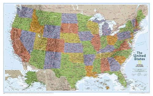

The United States Explorer map is a classic example of the cartographic excellence National Geographic is known for. This colorful political map clearly shows state boundaries, capitals, major highways, rivers, lakes, and many major cities. Insets show detail of Alaska and Hawaii. The color palette is vibrant and stunning shaded relief provides additional texture and detail.
The map is encapsulated in heavy-duty 1.6 mil laminate which makes the paper much more durable and resistant to the swelling and shrinking caused by changes in humidity. Laminated maps can be framed without the need for glass, so the fames can be much lighter and less expensive.
- Map Scale = 1:6,396,000
- Sheet Size = 32" x 20.25"
"synopsis" may belong to another edition of this title.
About the Author:
Founded in 1915 as the Cartographic Group, the first division of National Geographic, National Geographic Maps has been responsible for illustrating the world around us through the art and science of mapmaking.Today, National Geographic Maps continues this mission by creating the world's best wall maps, recreation maps, atlases, and globes which inspire people to care about and explore their world.
"About this title" may belong to another edition of this title.
- PublisherNatl Geographic Society Maps
- Publication date2019
- ISBN 10 1597750093
- ISBN 13 9781597750097
- BindingMap
- Number of pages1
- Rating
Top Search Results from the AbeBooks Marketplace

Stock Image
National Geographic: United States Explorer Wall Map - Laminated (32 X 20.25 Inches): Wall Maps U.S. (National Geographic Reference Map)
Published by
NATL GEOGRAPHIC MAPS
(2019)
ISBN 10: 1597750093
ISBN 13: 9781597750097
Used
Quantity: 1
Seller:
Rating
Book Description Condition: Gut. 019. 1 Seiten Gebrauchs- und Lagerspuren. 19. Auflage. 23311804/3 Altersfreigabe FSK ab 0 Jahre Landkarte, Gr��e: 8.6 x 7.9 x 91.4 cm. Seller Inventory # 233118043
Buy Used
US$ 18.13
Convert currency
Stock Image
National Geographic: United States Explorer Wall Map - Laminated (32 X 20.25 Inches): Wall Maps U.S. (National Geographic Reference Map)
Published by
NATL GEOGRAPHIC MAPS
(2019)
ISBN 10: 1597750093
ISBN 13: 9781597750097
Used
Quantity: 7
Seller:
Rating
Book Description Condition: Sehr gut. 019. 1 Seiten Gepflegter, sauberer Zustand. 19. Auflage. 23311804/2 Altersfreigabe FSK ab 0 Jahre Landkarte, Gr��e: 8.6 x 7.9 x 91.4 cm. Seller Inventory # 233118042
Buy Used
US$ 18.13
Convert currency