1719 FOUR Antique Road Maps LONDON to ST DAVIDS WALES Gloucestershire (38)
From Antique Paper Company, ASHFORD, KENT, United Kingdom
Seller rating 2 out of 5 stars
![]()
AbeBooks Seller since September 26, 2019
From Antique Paper Company, ASHFORD, KENT, United Kingdom
Seller rating 2 out of 5 stars
![]()
AbeBooks Seller since September 26, 2019
About this Item
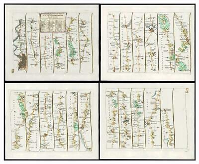
Listing Template 2018 Home About Us View Feedback Contact Us 1719 FOUR Antique Road Maps LONDON to ST DAVIDS WALES Gloucestershire (38)Description1719Set of fourOriginal Antique Road Maps titledThe ROAD from LONDON to ST DAVID'S ON THE SEA COAST IN PEMBROKESHIREA superb FIRST ISSUE very early set of four roadmaps by John Senex showing the road starting from London Colebrook, Maidenhead, Henley, Abingdon, Farringdon, Gloucester, Monmouth, Newport, Cardiff, St Nicholas, Aberavon, Swanley, Kidwelly, Haverford West and on to St David's.CONDITION:Superb condition, especially being from the First Edition. Good margins, perfect for mounting and framing and with hand colouring. Overall size of each Map including margins 23cm x 19cm.John Senex (1678-1740), was born in Ludlow. In 1695 he was apprenticed to the London bookseller Robert Clavell. He became a renowned engraved and seller of maps and globes and certainly one of the more respected cartographers of the 18th Century.Senex started his own business in 1702, working the London hotbed of cartographic creativity that was the Strand and then in Cornill until 1706. He formed a partnership with various map-makers including Jeremiah Seller and Charles Price who were the successors of map maker, John Seller.During the course of his career as en engraved and publisher, John Senex produced a vast array of cartography, from maps of the world and the continents as well as individual county maps of phenomenal detail. But it is for his Road Maps that he is best known and 1719 saw is shamm version of John Ogilby's 'Britannia' - a series of superb strip maps, larger than Owen Bowen's and smaller than Thomas Gardner's/ It ran through many editions with this map being from the FIRST ISSUE. View Our Categories Decorative Prints World Wide Maps Scotland Maps Architecture Design England Maps Royalty About UsWe specialise in selling all items that can be considered to be Antique Paper. * PRINTS * MAPS * HISTORICAL DOCUMENTS * POSTAL HISTORY * BOOKS * POSTERS * STAMPS * POSTCARDS * EPHEMERA And anything else that is considered Antique and made of Paper. ALL OF OUR ITEMS ARE ORIGINAL ANTIQUES - NOT MODERN COPIES. We are also very keen buyers of anything similar and especially after better collections, original archives, whole libraries and better single items and have and#163;250,000 in cash funds at anyone time to buy the right items. Contact UsIf you have any questions then please do not hesitate to contact us through the eBay messaging system. Feedback We will always help you to have a 100% positive happy buying experience. Contact us if you are unhappy about any aspect of your purchase from us. We only want five star feedback from you so buy with confidence. Seller Inventory # 234147368495_e70b035
Bibliographic Details
Title: 1719 FOUR Antique Road Maps LONDON to ST ...
Store Description
All items offered via AbeBooks are offered, subject to availability and to prior sale.
We welcome orders via AbeBooks using the shopping cart provided, or by phone or email.
All orders are dealt with in order of receipt and we usually try to ship within 3 working days of order, except those that require Express Shipping, which will be dispatched same or next working day.
All items remain the property of Antique Paper Company until payment has been received and cleared in full.
All orders can be ...
All shipping costs will be confirmed on receipt of any order. We provide many shipping options and are happy to ship all over the world.
Payment Methods
accepted by seller