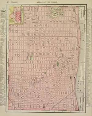
Detroit
Rand McNally
From
Art Source International Inc., Boulder, CO, U.S.A.
Seller rating 2 out of 5 stars
![]()
AbeBooks Seller since July 13, 2001
About this Item
Description:
This map comes from the Rand McNally Universal Atlas printed in 1895. This detailed map of Detroit shows the main portion of the city This map measures 12.5 inches by 9.25 inches. Seller Inventory # 71136
Bibliographic Details
Title: Detroit
Publication Date: 1895
Top Search Results from the AbeBooks Marketplace
Rand McNally Folded Map: Detroit and Southeastern Michigan Regional Map
Seller: Revaluation Books, Exeter, United Kingdom
Condition: Brand New. In Stock. Seller Inventory # x-0528028480
Quantity: 1 available
Rand McNally Folded Map: Detroit and Southeastern Michigan Regional Map
Seller: AHA-BUCH GmbH, Einbeck, Germany
Karte. Condition: Neu. Neuware. Seller Inventory # 9780528028489
Quantity: 2 available
Rand McNally Folded Map: Detroit Street Map
Seller: Revaluation Books, Exeter, United Kingdom
Map. Condition: Brand New. 14.25x9.25x0.32 inches. In Stock. Seller Inventory # 0528024922
Quantity: 1 available
Map of the main portion of Detroit; Inset outline map of Detroit
Seller: Antiqua Print Gallery, London, United Kingdom
Condition: Good. Detroit town city map plan. Michigan. RAND MCNALLY 1906 old antique chart. Antique colour (color) city plan; Rand McNally (1906). 27.5 x 33.5cm, 10.75 x 13.25 inches. Condition: Good. There are images and/or text printed on the reverse side of the picture. In some cases this may be visible on the picture itself or around the margin of the picture. Seller Inventory # P-7-021053
Quantity: 1 available
Map: Detroit
Seller: Bohemian Bookworm, Flemington, NJ, U.S.A.
No Binding. Condition: Very Good. Dampstaining along margins and onto map on lower corners, local railroads in red, 2-sided, ready for framing, uncut, uncreased, counties in various colours, map measures 19" x 26". Seller Inventory # 92818
Quantity: 1 available
Rand McNally Folded Map: Detroit Street Map
Seller: Books Unplugged, Amherst, NY, U.S.A.
Condition: New. Buy with confidence! Book is in new, never-used condition 0.11. Seller Inventory # bk0528024922xvz189zvxnew
Quantity: 1 available
Rand McNally Street Guide Detroit/Sub Wayne County Michigan
Seller: ThriftBooks-Dallas, Dallas, TX, U.S.A.
Paperback. Condition: Good. No Jacket. Pages can have notes/highlighting. Spine may show signs of wear. ~ ThriftBooks: Read More, Spend Less 1.32. Seller Inventory # G0528993240I3N00
Quantity: 1 available
Rand Mcnally Indexed Pocket Map Tourists' And Shippers' Guide Of Illinois The Standard Accident Insurance Company Of Detroit
Seller: Wabash Museum Books, Mount Carmel, IL, U.S.A.
Soft cover. Condition: Fair. No Jacket. Thomas Derrick (illustrator). 75 Pages With Ads On Pages In Rear Of Book. Staple Binding; Pages Tight; Yellowed; Moderate Page Wear. Page Edges Darkened. No Markings; Beige Soft Covers With Black Lettering And Border On Front Cover; Ad For Shaving Lather On Back Cover. Small Tears On Spine Near Staples. Contains Guide For Railroads, Electric Lines, Post Offices, Express Telegraph And Mail Service. Also Alphabetical List Of Counties, Congressional Townships, Cities, Towns, Villages, Rivers, Lakes, Islands, Creeks, Etc.; Population According To The Latest Official Census And Main Highways. Very Rare Vintage Copy. Seller Inventory # S44-B7532-10476
Quantity: 1 available
Rand McNally Folded Map: Detroit and Southeastern Michigan Regional Map
Seller: Save With Sam, North Miami, FL, U.S.A.
map. Condition: New. 0.3500. Seller Inventory # VIB0528025457
Quantity: 1 available
Rand McNally Detroit & Wayne County Streetfinder
Seller: Ergodebooks, Houston, TX, U.S.A.
Softcover. Condition: Good. Seller Inventory # SONG0528969471
Quantity: 1 available


