
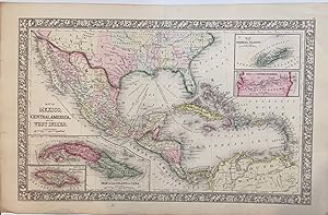
Map of Mexico, Central America, and the West Indies
MITCHELL, Samuel Augustus Jr.
Published by Mitchell, Samuel Augustus Jr., Philadelphia, 1866
Used
unbound
From
Argosy Book Store, ABAA, ILAB, New York, NY, U.S.A.
Seller rating 5 out of 5 stars
![]()
Heritage Bookseller
AbeBooks member since 1996
This specific copy is no longer available. Here are our closest matches for Map of Mexico, Central America, and the West Indies by MITCHELL, Samuel Augustus Jr..
About this Item
Description:
Map. Engraving with original hand coloring. Image measures 13.25" x 21". Beautiful map of Mexico published in 1866. centered on the Gulf of Mexico. Includes four inset maps; Jamaica, Cuba, Bermuda and Panama. Samuel Augustus Mitchell Sr. (1792-1868) was one of the leaders in American cartography of the 19th century and pioneered the conversion of engraved map plates to more affordable lithographic plates. His son, Samuel Augustus Mitchell Jr. continued his father's successful mapmaking and publishing business, and was one of the most prolific and renowned 19th century American publishers. Seller Inventory # 297675
Bibliographic Details
Title: Map of Mexico, Central America, and the West...
Publisher: Mitchell, Samuel Augustus Jr., Philadelphia
Publication Date: 1866
Binding: unbound
Illustrator: W. Williams
Top Search Results from the AbeBooks Marketplace

Map of Mexico, Central America, and the West Indies
Published by
Philadelphia, 1870
Used
Seller: Nicholas D. Riccio Rare Books, ABAA, Florham Park, NJ, U.S.A.
Seller rating 4 out of 5 stars
![]()
Unbound, colored engraved map, decorative border, double page, 22" x 14". Slight toning and aging; overall bright and clear and in very good shape. Maps are wrapped with acid free board, or in rigid sleeves. The Mitchell family started to produce atlases in 1846, and continued into the early 1890s. Around 1860, S. Augustus Mitchell Jr. took over, and the atlas would be called Mitchell's New General Atlas. This is an attractive double page map of Central America from the 1870 installment of that atlas. Bermuda, Jamaica, a map of the Panama Railroad, and a map of Cuba are highlighted within insets. Ristow 311-313 Phillips 907. Seller Inventory # 101214
Quantity: 1 available
Map of Mexico, Central America, and the West Indies
Published by
Bradley, Philadelphia, 1882
Used
Seller: Nicholas D. Riccio Rare Books, ABAA, Florham Park, NJ, U.S.A.
Seller rating 4 out of 5 stars
![]()
Unbound, colored engraved map, 22 1/2"x 14 1/2". Some toning and aging, a little darkening at fold; otherwise very good. Maps are wrapped with acid free board, or in rigid sleeves. The Mitchell family started to produce atlases in 1846, and continued into the early 1890s. Around 1860, S. Augustus Mitchell Jr. took over, and the atlas would be called Mitchell's New General Atlas. This is an attractive double page map of Central America from the 1882 installment of that atlas. Bermuda, Jamaica, a map of the Panama Railroad, and a map of the proposed Panama Canal route are highlighted within insets. Ristow 311-313 Phillips 907. Seller Inventory # 101042
Quantity: 1 available
Map of Mexico, Central America, and the West Indies
Published by
Philadelphia, 1865
Used
Seller: Nicholas D. Riccio Rare Books, ABAA, Florham Park, NJ, U.S.A.
Seller rating 4 out of 5 stars
![]()
Philadelphia, 1865. Unbound, colored engraved map, decorative boarder 22 1/2"x 14 1/2". Slight toning and aging; overall bright and clean and in very good condition. Maps are wrapped with acid free board, or in rigid sleeves. The Mitchell family started to produce atlases in 1846, and continued into the early 1890s. Around 1860, S. Augustus Mitchell Jr. took over, and the atlas would be called Mitchell's New General Atlas. This is an attractive double page map of Central America from the 1865 installment of that atlas. Bermuda, Jamaica, a map of the Panama Railroad, and a map of Cuba are highlighted within insets. May require extra postage.Ristow 311-313 Phillips 907. Seller Inventory # 101130
Quantity: 1 available

Seller Image
Map of Mexico, Central America, and the West Indies
Published by
Mitchell, Samuel Augustus Jr., Philadelphia, 1860
Used
Seller: Argosy Book Store, ABAA, ILAB, New York, NY, U.S.A.
Seller rating 5 out of 5 stars
![]()
unbound. W. Williams (illustrator). Map. Engraving with original hand coloring. Image measures 13.25" x 21". Beautiful first edition map of Mexico, Central America, and the Caribbean published in 1860. Centered on the Gulf of Mexico. Includes four insets: Map of the island of Jamaica, Mpa of the Island of Cuba, Map of the Bermuda Islands, and Map of the Panama Railroad. This map is in very good condition. Folded as issued. Minor chipping to bottom of centerfold, not affecting the image. Samuel Augustus Mitchell Sr. (1792-1868) was one of the leaders in American cartography of the 19th century and pioneered the conversion of engraved map plates to more affordable lithographic plates. His son, Samuel Augustus Mitchell Jr. continued his father's successful mapmaking and publishing business, and was one of the most prolific and renowned 19th century American publishers. Seller Inventory # 326133
Quantity: 1 available
Seller Image
Map of Mexico, Central America, and the West Indies
Published by
Mitchell, Samuel Augustus Jr., Philadelphia, 1866
Used
Seller: Argosy Book Store, ABAA, ILAB, New York, NY, U.S.A.
Seller rating 5 out of 5 stars
![]()
unbound. W. Williams (illustrator). Map. Engraving with original hand coloring. Image measures 13.25" x 21". Beautiful map of Mexico, Central America, and the Caribbean published in 1866. Centered on the Gulf of Mexico. Includes four insets: Map of the island of Jamaica, Map of the Island of Cuba, Map of the Bermuda Islands, and Map of the Panama Railroad. This map is in good condition. Minor chips and tears at edges, not affecting the image. Minor creasing near centerfold line. Samuel Augustus Mitchell Sr. (1792-1868) was one of the leaders in American cartography of the 19th century and pioneered the conversion of engraved map plates to more affordable lithographic plates. His son, Samuel Augustus Mitchell Jr. continued his father's successful mapmaking and publishing business, and was one of the most prolific and renowned 19th century American publishers. Seller Inventory # 326134
Quantity: 1 available