Order Total (1 Item Items):
Shipping Destination:

Clark, William 1770 to 1838 (26 results)
Skip to main search results
Product Type
- All Product Types
- Books (26)
- Magazines & Periodicals
- Comics
- Sheet Music
- Art, Prints & Posters
- Photographs
- Maps
-
Manuscripts &
Paper Collectibles
Condition
Binding
Collectible Attributes
- First Edition (3)
- Signed
- Dust Jacket
- Seller-Supplied Images (5)
- Not Printed On Demand
Free Shipping
Seller Location
Seller Rating
-
Condition: New.
More buying choices from other sellers on AbeBooks
New offers from US$ 23.50
-

THE HISTORY OF THE LEWIS AND CLARK EXPEDITION. 3 VOLUME SET
Published by Dover Publications, Inc, New York
Book
Soft cover. Condition: Very Good. No Jacket. THREE VOLUMES 21.5 x 10.5 cm, cxxxii, 352, [many pages of advertisements]; vi, 353-820, [many pages of advertisements]; vi,821-1364,[many pages of advertisements] pp., large folding map in the back of volumes 1 and 2, no date, no markings, only minor bumping to corners, otherwise finer.
-
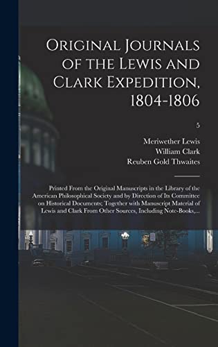
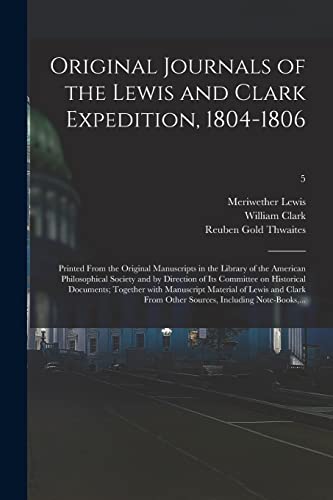
Original Journals Of The Lewis And Clark Expedition, 1804-1806; Printed From The Original Manuscripts In The Library Of The American Philosophical Society And By Direction Of Its Committee On Historical Documents; Together With Manuscript Material Of.; 5
Published by Legare Street Press, 2021
ISBN 10: 1013353897ISBN 13: 9781013353895
Book
Condition: New.
More buying choices from other sellers on AbeBooks
New offers from US$ 33.54
Used offers from US$ 35.98
Also find Hardcover
-
Letters and Documents Informing the Indians of the End of the War of 1812, St. Louis, May 15, 1815 / Letters and Documents Related to a Dispute of the Potawatomi Indians, St. Louis, March 1815
Published by Wisconsin Historical Society, A Bound / Flex Cover / REPRINT
Condition: Underlining-Highlighting-as is. Illustrated with reprints of the Original Documents (illustrator). 20 pages. pages. Paper / Soft cover reprint edition in very good or better condition, slight wear to edges. Overall good copy of this scarce title. Excellent source, informative and enjoyable reading. A good book to read and keep on hand. Or would make a great gift for the fan / reader in your life. This is facsimiles of 2 historical documents, and the transcripted text. Author Note : After returning from the 1804-1806 expedition, William Clark was appointed U.S. Superintendent of Indian Affairs (1807-1813), governor of Missouri Territory (1813-1821) and then Superintendent of Indian Affairs again ( 1822 to 1838 ). The documents given here show him at work resolving a grievance of the Potawatomi indians. Book.
-
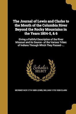
JOURNAL OF LEWIS & CLARKE TO T
Published by WENTWORTH PR, 2016
ISBN 10: 1371162212ISBN 13: 9781371162214
Book
Kartoniert / Broschiert. Condition: New.
-
Upper Mandane Village, Oct. 31, 1804. To Charles Chaboiller." Pp. 448-449. In: The Port Folio. Edited by Oliver Oldschool. New Series. Vol. VII, no. 5.
Published by [Philadelphia,] May 1812., 1812
8vo., (8 4/8 x 5 2/8 inches). Engraved frontispiece of the Hudson River, and 2 engraved plates (first page of text torn, spotted and browned throughout). Disbound; preserved in modern brown cloth slipcase and chemise. Lewis and Clark's letter is to Charles Chaboiller of the North West Company, providing information about their arrival at the Mandan Village on 26 October 1804. There they met Hugh M'Crachen of the North West Company who was employed to traffic with the natives. They write that they "have been commissioned and sent by the government of the United States for the purpose of exploring the river Missouri, and the western parts of the continent of North America, with a view to the promotion of general science. Your government have been advised of this voyage and its objects.The cold season having now nearly arrived, we have determined to fortify ourselves.During our residence here, or future progress of our voyage, we calculate that the injunctions contained in the passport before mentioned will, with respect to ourselves, govern the conduct of such of his Brittanic Majesty's subjects, as may be within communicative reach of us.We shall, at all times, extend our protection as well to British subjects as American citizens, who may visit the Indians of our neighbourhood, provided they are well-disposed.[we do this] as from a conviction that it is consonant with the liberal policy of our government." Over the long winter at Fort Mandan, near the mouth of the Knife River in present North Dakota, Lewis and Clark made copious notes in their journals and spoke with Indian leaders. This is an early appearance in print from Lewis and Clark's expedition; their 'Travels.' was not published until 1814.
-
ORIGINAL JOURNALS OF THE LEWIS AND CLARK EXPEDITION 1804-1806. VOLUME ONE, TWO, THREE, FOUR, FIVE, SIX, SEVEN, and EIGHT. [Complete set; Vol. 1-I, 2-II, 3-III, 4-IV, 5-V, 6-VI, 7-VII, & 8-VIII; Lewis & Clark.]
Published by New York: Arno Press, Inc., 1969., 1969
COMPLETE EIGHT VOLUME SET. All hardcover; Volumes I-VII being H 23.5cm x L 15.5cm with Volume VIII being H 23.5cm x L 16.25cm. No dust jackets (presumably as issued). Red cloth bindings; front boards decorated with facsimile manuscript paste-ons; gilt stamping to spines remains bright save for Volume V which has dulling/flaking; varied mottling and discoloration/fading to boards. Text block edges have foxing with soiling occurring to bottom edge corners adjoining fore-edge heels; Volume IV has small brown stain upon its top edge fractionally affecting top margins of pages 73-132; interior leaves overall remain quite clean. Bindings retain some crispness. Whereas Volume I-VII are text, the concluding Volume VIII is a clamshell case with contents collating complete - features introductory brochure and all maps present as called for (all being foldout single-sided sheets with most having one map per sheet) being numbered as 1-13, 14-1, 14-2, 14-3, 15-21, 22A, 23-25, 26, 26A, 27-28, 29, 29-A, 30-1, 30-2, 30-3. 31-1, 31-2, 32-1, 32-2, 32-3, 33-37, 38/39 (the exception being two maps reproduced upon one sheet), and 40-54; a few wrinkles and a new crease or two among the map sheets but otherwise clean. Still a very good set. Please note that this set has an approximate shipping weight of 15.5 pounds (7.03 kg) and will require additional postage for any postal class other than domestic Media Mail.
-
Hardcover. Condition: very good. Later ed. Two 12mo uniform volumes in dark brown polished cloth-backed boards; 371 & 395p; 1 b&w folded map to frontis of vol 1 ; 16 cm. Spine titles read: The Family library [;] Rocky Mountains [;] Lewis & Clarke [;] Vol. 1 [or] 2. || Exploration of North America. Discoveries in geography. Travel.West (U.S.) -- History -- To 1848. Western (U.S.) -- Description and travel. Missouri River -- Description and travel. Columbia River -- Description and travel. West (U.S.) -- Discovery and exploration. Missouri River. United States -- Columbia River. An altogether very good set with a few minor flaws: rear end paper of volume two partly torn (closed tear); minor edge-wear and chafing to board edges; a bit of foxing, mainly to endpaper and preliminary; else tight, clean and very good.
-
Atlas of the Lewis & Clark Expedition (The Journals of the Lewis & Clark Expedition, Vol. 1)
Published by University of Nebraska Press, Lincoln, Nebraska, 1983
Book
Hardcover. Condition: New. Limited Edition. University of Nebraska Press, Lincoln:, 1983. Hardcover. First Edition, Second Printing First Printing of first edition in blue decorated cloth covered boards with bold gilt text stamping on the spine and with the same on the front board together with a serpentine blue decoration in the lower fore corner. Without a dust jacket as issued. A large folio measuring 19 1/2" by 13 1/2" containing an introduction of 13 pages, followed by five pages of notes which relate to the maps, four pages of "a Calendar of Maps", a map index and 126 full page maps. The first volume in The Journals of the Lewis & Clark Expedition as produced by the University of Nebraska Press under the direction of Gary Moulton as editor. This volume contains reproductions of all of the maps created by Captain Clark on the expedition. Uncommon.
-
Atlas of the Lewis & Clark Expedition (The Journals of the Lewis & Clark Expedition, Vol. 1)
Published by University of Nebraska Press, Lincoln, Nebraska, 1983
Book
Hardcover. Condition: New. Limited Edition. Limited numbered and signed edition in special fancy clam shell box. Two copies #10 and #13 of 100. University of Nebraska Press, Lincoln:, 1983. Hardcover. First Edition, Second Printing. Second Printing Fine in blue decorated cloth covered boards with bold gilt text stamping on the spine and with the same on the front board together with a serpentine blue decoration in the lower fore corner. Without a dust jacket as issued. A large folio measuring 19 1/2" by 13 1/2" containing an introduction of 13 pages, followed by five pages of notes which relate to the maps, four pages of "a Calendar of Maps", a map index and 126 full page maps. Note: This appears to be an early state of the second printing as the board sizes conform to the second printing production, but the copyright page shows only a date of "1983" with no second printing slug. The first volume in The Journals of the Lewis & Clark Expedition as produced by the University of Nebraska Press under the direction of Gary Moulton as editor. This volume contains reproductions of all of the maps created by Captain Clark on on the expedition. Exceedingly uncommon.
-
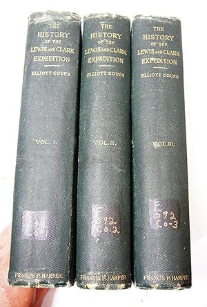
History of the Expedition Under the Command of Lewis and Clark to the sources of the Missouri, thence across the Rocky Mountains and down the river Columbia to the Pacific Ocean, performed during the Years 1804-5-6 by Order of the Government of the United States
Published by Francis P. Harper, 1893
Book
Hardcover. Condition: Fair. FAIR SET! MISSING VOLUME IV!!! #904 of Edition Limited to One Thousand Copies!! Great majority of substance is in the first three volumes. From private library with private library stamp on title page of each volume with library number on spine and name on front end paper. No other marks or writings, pages bright and clean with very little foxing, Volume I binding is mildly loose with binding fabric showing on both hinges, moderate wear to corners and spine ends. Volumes II and III hinges in better shape but starting to show binding fabric, Volume II with pronounced scratch on front cover, both with moderate wear to spine ends and corners. More images upon request. Carefully packaged and shipped in box! Z5.
-
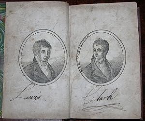
New Travels Among the Indians of North America; being a compilation, taken partly from the communications already published, of Captains Lewis and Clark, to the President of the United States.
Published by Philadelphia: James Sharan, 1812., 1812
12mo (7 1/8 x 4 5/8 inches): dual wood-engraved frontispiece portraits of Lewis and Clark (a bit spotted). Bound in library binding (browned and spotted throughout). PROVENANCE: contemporary pen trials to frontispiece. First edition. So-called "apocryphal edition" of Lewis and Clark, bearing the name of compiler William Fisher on the title page. According to Paltsits, "In most copies the second title page is lacking," as here. "Another surreptitious account, allegedly written by William Fisher, Esquire, was published by James Sharan and printed in Philadelphia by James Mawell in 1812. It sold for $1.25. The title, 'New Travels Among the Indians of North America; Being a Compilation, Taken Partly from the Communications Already Published, of Captains Lewis and Clark,' admitted that the book was a compilation and was 'taken partly from other authors.' The contents included the one paragraph 'Recommendation' of Thomas Jefferson and an 'Introduction' that was a paraphrase of that in the surreptitious volumes published in 1809 in Philadelphia and London. Fisher wrote with the same gratuitous but hollow language of Hubbard Lester: 'The advantages, that arise from the discoveries of unknown regions, are too numerous to be mentioned,' he noted. 'They arise one after another in continual succession. Geography, Civilization, Humanity, and the Arts and Sciences, received aid from them.' The 'New Travels' included Clark's letter from Fort Mandan of April 2, 1805; Clark's letter from St. Louis of September 23, 1806; data on the tribes that was identified as taken from the pen of Alexander Mackenzie; the 'Statistical View'; and the irrelevant fillers about Master Neddy and George Washington. The volume was little more than a reprint of the book of Hubbard Lester with a new author and a more honest title.William Fisher and Hubbard Lester were probably the convenient pseudonyms of a wily publisher" (Beckham, pp. 125-126). REFERENCES: Stephen Dow Beckham, "The Literature of the Lewis and Clark Expedition: A Bibliography and Essays." Wagner-Camp 8:6. Sabin 24509. Howes F153a, "aa." American Imprints 26261.
-
Travels In The Interior Parts Of America; Communicating Discoveries Made In Exploring The Missouri, Red River And Washita, By Captains Lewis And Clark, Doctor Sibley, And Mr. Dunbar; With A Statistical Account Of The Countries Adjacent. As Laid Before The Senate, By The President Of The United States. In February, 1806, And Never Before Published In Great Britain.
Published by London: Printed For Richard Phillips By J.G.Barnard, 1807., 1807
Seller: D & E LAKE LTD. (ABAC/ILAB), Toronto, ON, Canada
Seller Rating:

First Edition
Hardcover. Condition: Near Fine. 1st Edition. 8vo. pp. 24, 17-116. folding table. modern half morocco. First London Edition of the earliest publication to give any account of the Lewis and Clark expedition, the most important western American exploration ever undertaken. Although the account is brief it precedes the publication of the official journal by a full seven years. "The Sibley-Dunbar descriptions of the Texas-Louisiana frontier gave the first formal and satisfactory picture of the southern portion of the Louisiana Purchase." (Howes) The driving force behind the appointment of the Lewis and Clark expedition was Thomas Jefferson, who urged Congress that it was of crucial importance to develop American trade with the Indians of the Missouri Valley and to strengthen the American presence in the western frontier. Preparations for the expedition were conducted in secrecy until the Louisiana Territory was sold to the United States by France in December 1803. Setting out in May of the following year, Lewis and Clark traveled up the Missouri River, wintered among the Mandans in North Dakota, and pushed westward overland, arriving at the mouth of the Columbia River on the north-west coast on November 20, 1805. Howes L-319. Sabin 40826. Wagner-Camp 5:6.
-
A Journal of the Voyages and Travels of a Corps of Discovery, under the Command of Capt. Lewis and Capt. Clarke. from the Mouth of the River Missouri through the Interior Parts of North America to the Pacific Ocean, during the Years 1804, 1805 & 1806.
Published by Philadelphia: Mathew Carey, 1810., 1810
12mo (6 6/8 x 4 inches): engraved frontispiece (laid down, spotted and browned) and five further plates. Bound in modern ochre morocco backed cloth gilt. PROVENANCE: with the book plate of James S. Copley on the front paste-down of each volume, his sale Sotheby's 15th October 2010 lot 731. Second Carey, third American, and second illustrated edition. Mathew Carey issued two editions in 1810 after acquiring the copyright from David McKeehan. First published in 1807. The first full published account of the Corps of Discovery by a member of the expedition, Patrick Gass, who "became one of the best-known members of the expedition for several reasons: his key role as sergeant brought his name up frequently in the journals of Lewis and Clark; his account was the first to be published; he was the first to have a biography written about him; and finally, he outlived the other members of the Corps of Discovery by decades" (Wagner-Camp-Becker 6:1). "Although [Gass's Journal] lacked the insight, reflection, and depth of geographic, ethnographic, diplomatic, and scientific observations penned by Lewis and Clark, it and Jefferson's Message from the President were the only accounts available for seven years to describe the expedition's adventures" (Beckham, p. 89). "Sergeant Patrick Gass outlived every person who served on the Lewis and Clark expedition whose fate is known. Having lived so long, Gass is one of the best known of the expedition's enlisted men and has had more written about him than any other man in the Corps of Discovery, except for the two captains" (DANB). REFERENCES: Graff 1518; Howes G77; Smith 3467; Streeter sale V:3123; Wagner-Camp-Becker 6:5. Catalogued by Kate Hunter. Book.
-
The Travels of Capts. Lewis & Clarke, by order of the United States, performed in the years 1804, 1805, & 1806, being upwards of three thousand miles, from St. Louis, by way of the Missouri, and Columbia Rivers, to the Pacifick Ocean.
Published by Philadelphia: Hubbard Lester, 1809., 1809
First Edition
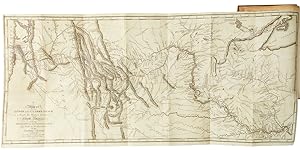
Full Leather. Condition: Very Good. 8vo (6 3/4 x 4 inches): folding engraved map of "the Country Inhabited by the Western Tribes of Indians" (early repairs to verso, browned and spotted), engraved frontispiece portrait of a Sioux Queen, and four engraved plates of tribal chiefs (spotted and browned throughout). Bound in contemporary American mottled sheep, the smooth spine gilt-ruled in six compartments, with red morocco lettering-piece in the second (hinges weak, extremities a bit rubbed, head of spine worn with minor loss). Provenance: With the contemporary ownership inscription of William Cook dated 1809 on the verso of the second blank. First edition of an early piece of Lewis and Clark "Apocrypha". Little more than a compilation and rehashing of Jefferson's "Message from the President" of 1806, letters written by William Clark, Patrick Gass's "Journal." published in 1807, and plagiarized portions of Jonathan Carver's "Travels Through the Interior Parts of North America." of 1778 and Alexander Mackenzie's "Voyages from Montreal", 1801. The only original contribution in this work if the engraved folding map: "the earliest published map with legends stemming from Lewis and Clark. Here were the earliest published cartographic reflections of Lewis and Clark's great effort, and this fact alone distinguishes this small map, which otherwise harks back to earlier days" (Wheat). Among the new features on the map is the presence of "F. Clatsop" at the mouth of the Columbia River. REFERENCES: Howes L-321; Streeter sale V:3122; Wagner-Camp 8:1; Wheat Transmississippi 294. Book.
-
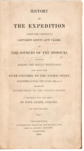
History of the Expedition Under the Command of Captains Lewis and Clark, to the Sources of the Missouri, Thence Across the Rocky Mountains and Down the River Columbia to the Pacific Ocean. Performed During the Years 1804-5-6
Published by J. Maxwell for Bradford & Inskeep and Abm. H. Inskeep of New York, Philadelphia, 1814
Seller: Donald A. Heald Rare Books (ABAA), New York, NY, U.S.A.
Seller Rating:

2 volumes, octavo. (8 1/4 x 5 inches). Five maps and charts. Large folding map in expert facsimile. Expertly bound to style in full tree calf, covers bordered with a gilt roll toll, flat spines in compartments divided by a gilt roll tool, black morocco lettering piece in the second compartments Provenance: Samuel Hegamin (signature dated 1814 on p. 1 of both volumes); Daniel L. Weckerly (signature dated 1838 on both titles) The first edition of the "definitive account of the most important exploration of the North American continent" (Wagner-Camp). A cornerstone of Western Americana. The book describes the Government-backed expedition to explore the newly acquired Louisiana Purchase undertaken from 1804 to 1806 by ascending the Missouri to its source, crossing the Rocky Mountains, and reaching the Pacific Ocean. In total, the expedition covered some eight thousand miles in slightly more than twenty-eight months. Lewis and Clark brought back the first reliable information about much of the area they traversed, made contact with the Indian inhabitants as a prelude to the expansion of the fur trade, and advanced by a quantum leap the geographical knowledge of the continent. This official account of the expedition is as much a landmark in Americana as the trip itself. The narrative has been reprinted many times and remains a perennial American bestseller. The observations in the text make it an essential work of American natural history, ethnography and science. It is the first great U.S. government expedition, the first book on the Rocky Mountain West, and a host of other firsts. It is among the most famous American books. Church 1309; Field 928; Graff 2477; Grolier American 100, 30; Howes L317; Printing & the Mind of Man 272; Tweney 89, 44; Sabin 40828; Shaw & Shoemaker 31924; Streeter Sale 1777; Streeter, Americana Beginnings, 52; Wagner-Camp 13:1.
-
History of the Expedition Under the Command of Captains Lewis and Clark, to the Sources of the Missouri, Thence Across the Rocky Mountains and Down the River Columbia to the Pacific Ocean. Performed During the Years 1804-5-6
Published by J. Maxwell for Bradford & Inskeep and Abm. H. Inskeep of New York, Philadelphia, 1814
Seller: Donald A. Heald Rare Books (ABAA), New York, NY, U.S.A.
Seller Rating:
2 volumes, octavo. 8 1/4 x 4 3/4 inches. Five maps and charts. Large folding map in expert facsimile. Contemporary sheep, rebacked to style, spine ruled in gilt, red morocco lettering piece. The first edition of the "definitive account of the most important exploration of the North American continent" (Wagner-Camp). A cornerstone of Western Americana. The book describes the Government-backed expedition to explore the newly acquired Louisiana Purchase undertaken from 1804 to 1806 by ascending the Missouri to its source, crossing the Rocky Mountains, and reaching the Pacific Ocean. In total, the expedition covered some eight thousand miles in slightly more than twenty-eight months. Lewis and Clark brought back the first reliable information about much of the area they traversed, made contact with the Indian inhabitants as a prelude to the expansion of the fur trade, and advanced by a quantum leap the geographical knowledge of the continent. This official account of the expedition is as much a landmark in Americana as the trip itself. The narrative has been reprinted many times and remains a perennial American bestseller. The observations in the text make it an essential work of American natural history, ethnography and science. It is the first great U.S. government expedition, the first book on the Rocky Mountain West, and a host of other firsts. It is among the most famous American books. Church 1309; Field 928; Graff 2477; Grolier American 100, 30; Howes L317; Printing & the Mind of Man 272; Tweney 89, 44; Sabin 40828; Shaw & Shoemaker 31924; Streeter Sale 1777; Streeter, Americana Beginnings, 52; Wagner-Camp 13:1.
-
Travels to the Source of the Missouri River and Across the American Continent to the Pacific Ocean in the Years 1804, 1805 and 1806
Published by Longman,Hurst, Rees, Orme, and Brown, London, 1814
Book First Edition
Hardcover. Condition: Very Good. No Jacket. 1st Edition. First London edition, first quarto edition, superior physically to the First edition of the same year published in Philadelphia. 27.5 X 20 cm, xxiv, 663, advertisements on verso of last page pp. Title page margins professionally repaired but printing all undamaged. the edge block of pages has dust discoloration WITH OPRIGINAL MAP IN VERY GOOD CONDITIION. Rebound in new attractive and appropriate red leather with gilt decorations and black leather label on spine. Prefaces by Thomas Jefferson, Meriwether Lewis and Thomas Rees.
-
HISTORY | OF |THE EXPEDITION | UNDER THE COMMAND OF | CAPTAINS LEWIS AND CLARK, | TO | THE SOURCES OF THE MISSOURI, | THENCE | ACROSS THE ROCKY MOUNTAINS | AND DOWN THE | RIVER COLUMBIA TO THE PACIFIC OCEAN. | PERFORMED DURING THE YEARS 1804-5-6 | By order of the | GOVERNMENT OF THE UNITED STATES. | PREPARED FOR THE PRESS | BY PAUL ALLEN, ESQUIRE. | IN TWO VOLUMES | VOL. [I./II.] | PHILADELPHIA: | PUBLISHED BY BRADSFORD AND INSKEEP: AND | ABM. H. INSKEEP, NEWYORK. | J. MAXWELL PRINTER. | 1814.
Published by PUBLISHED BY BRADSFORD AND INSKEEP: ABM. H. INSKEEP, J. MAXWELL PRINTER, Philadelphia, New York, 1814
Book
Hardcover. Condition: Good. First edition, TWO VOLUMES, 21 x 13 cm. each, Vol I.: xxviii, [1]-470; Vol. II: [x], [1]- 522. [Church 1309; Coues, cxxiii; Cutright, pp. 53-72; Field 928; Graff 2477; Grolier 100 American Books #?; Howes L317; Jackson, Letters, p.494ff.; Palsits lxxvii; Printing and the Mind of Man, 272; Sabin 855, 40828; Smith 5894; Streeter III 177, Wagner Camp Becker 13] In black cloth slip case, Water stained and two pages repaired. Early calf boards professionally re-attached. Head and tail of both spines damaged but neatly repaired Original full calf binding with gilt lettered black labels, professionally restored with new hinges and heads and tails of spine. Large folding map in FACSIMILE. Wagner calls this "The definitive account of the most important exploration of the North American continent." Alfred C. Berol declares: "Subsequent to the discovery of American itself, the Lewis and Clark Expedition is the most important event in American history". An account of the first overland expedition to the Pacific coast and back, Lewis and Clark is the most famous of all western travels, and the cornerstone of any collection of Western Americana. An expedition to the Pacific was conceived by President Thomas Jefferson?s father, Peter, and was a life long ambition of Thomas. As President he was finally able to set the trip in motion. Jefferson always considered it to be a scientific and geographical expedition, but he sold it to Congress as a way to establish trading ties with the Indians of the western regions. The expedition covered some 8,000 miles in 28 months, following the Missouri River from its juncture with the Mississippi to its source and, crossing the Continental Divide, explored the Columbia River from the Rocky Mountains to the Pacific Ocean. Lewis and Clark always intended to publish their journals immediately upon their return - Lewis issued a prospectus for the work - but publication was delayed, initially by Lewis's new duties as Governor of the Louisiana Territory, and Clark's preoccupation as Superintendent of Indian Affairs. After Lewis' suicide in 1809, Clark hired Nicholas Biddle to actually write the book, but when Biddle was elected to Pennsylvania State Senate in 1812, he left the proof reading to Paul Allen, who put his name on the title page. Original full calf binding with gilt lettered black labels, professionally restored with new hinges and heads and tails of spine. Large folding map in facsimile.